
Vilyuy
Encyclopedia
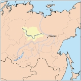
The Vilyuy River is river of the Central Siberian Plateau
, longest tributary of the Lena River
.
At a length of approximately 2,650 km long, it is mostly within the Sakha Republic. Its basin extends to about 491,000 km².
The Vilyuy rises in the Evenky autonomous okrug and, flowing east, soon enters Sakha.
It turns towards the south and southeast, then back towards the east, and finally enters the Lena about 350 km downstream of Yakutsk
, near Sangar
. To the west of the Vilyui and Chona is the Nizhnyaya Tunguska River basin.
The Vilyuy basin is sparsely populated. Small settlements along the river include Vilyuysk
, Verkhnevilyuysk, Suntar, and Nyurba
.
The river is first mentioned in the 17th century in connection with the Russian conquest of Siberia
.
In 1634, Russian Cossacks, headed by Voin Shakhov, established a winter settlement at the confluence of the Vilyuy and Tyuken Rivers. This settlement served as the administrative center of the area for several decades, after which it was moved to the Yolyonnyokh area 45 kilometres (28 mi) down by the Vilyuy River, where the ostrog (fortified settlement) of Olensk (now Vilyuysk) was founded in 1773.
In the 1950s, diamond deposits were discovered in the area, about 700 km from its mouth.
This led to the construction of the Mir Mine
, together with access roads and an airport, and the Vilyuy Dam complex to generate power needed for the diamond concentrators.
Central Siberian Plateau
The Central Siberian Plateau is made up of sharply demarcated surfaces of varying altitudes occupying most of Siberia between the Yenisei and Lena rivers. It extends over an area of 3.5 million km². The highest point is the Putoran Mountains rising to 1701 m. To the north of the plateau are...
, longest tributary of the Lena River
Lena River
The Lena is the easternmost of the three great Siberian rivers that flow into the Arctic Ocean . It is the 11th longest river in the world and has the 9th largest watershed...
.
At a length of approximately 2,650 km long, it is mostly within the Sakha Republic. Its basin extends to about 491,000 km².
The Vilyuy rises in the Evenky autonomous okrug and, flowing east, soon enters Sakha.
It turns towards the south and southeast, then back towards the east, and finally enters the Lena about 350 km downstream of Yakutsk
Yakutsk
With a subarctic climate , Yakutsk is the coldest city, though not the coldest inhabited place, on Earth. Average monthly temperatures range from in July to in January. The coldest temperatures ever recorded on the planet outside Antarctica occurred in the basin of the Yana River to the northeast...
, near Sangar
Sangar
Sangar is a small temporary fortified position with a breastwork originally of stone now built of sandbags and similar materials. The term was originally used by the British Indian Army to describe small temporary fortified positions on the North West Frontier and in Afghanistan, and is still...
. To the west of the Vilyui and Chona is the Nizhnyaya Tunguska River basin.
The Vilyuy basin is sparsely populated. Small settlements along the river include Vilyuysk
Vilyuysk
Vilyuysk is a town and the administrative center of Vilyuysky District of the Sakha Republic, Russia, located about from Yakutsk on the Vilyuy River...
, Verkhnevilyuysk, Suntar, and Nyurba
Nyurba
Nyurba is a town in the Sakha Republic, Russia, located on the Vilyuy River, a right-hand tributary of the Lena, northwest of Yakutsk. Population: -History:It was founded in 1930, although the area has been settled since the middle of the 18th century...
.
The river is first mentioned in the 17th century in connection with the Russian conquest of Siberia
Russian conquest of Siberia
The Russian conquest of Siberia took place in the 16th and 17th centuries, when the Siberian Khanate had become a loose political structure of vassalages which were becoming undermined by the activities of Russian explorers who, though numerically outnumbered, pressured the various family-based...
.
In 1634, Russian Cossacks, headed by Voin Shakhov, established a winter settlement at the confluence of the Vilyuy and Tyuken Rivers. This settlement served as the administrative center of the area for several decades, after which it was moved to the Yolyonnyokh area 45 kilometres (28 mi) down by the Vilyuy River, where the ostrog (fortified settlement) of Olensk (now Vilyuysk) was founded in 1773.
In the 1950s, diamond deposits were discovered in the area, about 700 km from its mouth.
This led to the construction of the Mir Mine
Mir Mine
Mir Mine also called Mirny Mine is an open pit diamond mine located in Mirny, Eastern Siberia, Russia. The mine is deep and has a diameter of , and is the second largest excavated hole in the world, after Bingham Canyon Mine...
, together with access roads and an airport, and the Vilyuy Dam complex to generate power needed for the diamond concentrators.