

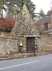
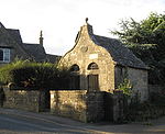
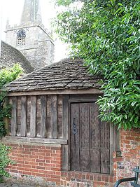
Village lock-up
Encyclopedia
England
England is a country that is part of the United Kingdom. It shares land borders with Scotland to the north and Wales to the west; the Irish Sea is to the north west, the Celtic Sea to the south west, with the North Sea to the east and the English Channel to the south separating it from continental...
and Wales
Wales
Wales is a country that is part of the United Kingdom and the island of Great Britain, bordered by England to its east and the Atlantic Ocean and Irish Sea to its west. It has a population of three million, and a total area of 20,779 km²...
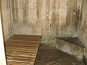
. They were often used for the confinement of drunks who were usually released the next day or to hold people being brought before the local magistrate. A typical village lock-up is a small structure with a single door and a narrow slit window or opening. Most lock-ups feature a dome or spire shaped roof and are commonly built from brick, large stones or timber. The village lock-up is found in a variety of shapes often round or polygonal in plan, usually freestanding but some are attached to or incorporated in other buildings. Variations in design, materials and appearance do occur although they were all built to perform the same function. Village lock-ups have acquired a range of local nicknames including blind-house, bone-house, bridewell
Bridewell Palace
Bridewell Palace in London, originally a residence of King Henry VIII, later became a poorhouse and prison. The name "Bridewell" subsequently became synonymous with police stations and detention facilities in England and in Ireland...
, cage, jug, kitty, lobby, guard-house, round-house, tower and watch-house.
Rise of the village lock-up

Barnaby Rudge
Barnaby Rudge: A Tale of the Riots of Eighty is a historical novel by British novelist Charles Dickens. Barnaby Rudge was one of two novels that Dickens published in his short-lived weekly serial Master Humphrey's Clock...
by Charles Dickens
Charles Dickens
Charles John Huffam Dickens was an English novelist, generally considered the greatest of the Victorian period. Dickens enjoyed a wider popularity and fame than had any previous author during his lifetime, and he remains popular, having been responsible for some of English literature's most iconic...
, and The Water-Babies, A Fairy Tale for a Land Baby
The Water-Babies, A Fairy Tale for a Land Baby
The Water-Babies, A Fairy Tale for a Land Baby is a children's novel by the Reverend Charles Kingsley. Written in 1862–1863 as a serial for Macmillan's Magazine, it was first published in its entirety in 1863...
by Charles Kingsley
Charles Kingsley
Charles Kingsley was an English priest of the Church of England, university professor, historian and novelist, particularly associated with the West Country and northeast Hampshire.-Life and character:...
which contains the following line:
'Put him in the round house till he gets sober.’
An 1830 description of a lock-up in Taunton
Taunton
Taunton is the county town of Somerset, England. The town, including its suburbs, had an estimated population of 61,400 in 2001. It is the largest town in the shire county of Somerset....
describes:
'. . . a hole into which drunken and bleeding men were thrust and allowed to remain until the following day when the constable with his staff of office take the poor, crippled and dirty wretches before a magistrate, followed by half the boys and idle fellows of the town.’
Some lock-ups also had stocks
Stocks
Stocks are devices used in the medieval and colonial American times as a form of physical punishment involving public humiliation. The stocks partially immobilized its victims and they were often exposed in a public place such as the site of a market to the scorn of those who passed by...
, ducking stools, pillories
Pillory
The pillory was a device made of a wooden or metal framework erected on a post, with holes for securing the head and hands, formerly used for punishment by public humiliation and often further physical abuse, sometimes lethal...
, or pinfold
Pinfold
Pinfold, in Medieval Britain, is an area where stray animals were rounded up if their owners failed to properly supervise their use of common grazing land...
s alongside them and the origins of the 18th century village lock-up evolved from much earlier examples of holding cells and devices.
The Oxford English Dictionary
Oxford English Dictionary
The Oxford English Dictionary , published by the Oxford University Press, is the self-styled premier dictionary of the English language. Two fully bound print editions of the OED have been published under its current name, in 1928 and 1989. The first edition was published in twelve volumes , and...
, for example, refers to a round-house as a place of detention for arrested persons and dates its first written usage to 1589.
In 1281 a structure similar to a common village lock-up (the Tun) was erected in Cornhill, central London. It was a two-storey barrel shaped design and had a single cell on each floor.
Decline and later uses

Justice of the Peace
A justice of the peace is a puisne judicial officer elected or appointed by means of a commission to keep the peace. Depending on the jurisdiction, they might dispense summary justice or merely deal with local administrative applications in common law jurisdictions...
to set up a paid police force in each county and made it compulsory for that force to be provided with proper police stations and secure cells. The village lock-up became a redundant edifice as a result and only a small fraction have survived the intervening century and a half.
During World War II
World War II
World War II, or the Second World War , was a global conflict lasting from 1939 to 1945, involving most of the world's nations—including all of the great powers—eventually forming two opposing military alliances: the Allies and the Axis...
many lock-ups were used by the Home Guard
British Home Guard
The Home Guard was a defence organisation of the British Army during the Second World War...
as sentry
British anti-invasion preparations of World War II
British anti-invasion preparations of the Second World War entailed a large-scale division of military and civilian mobilisation in response to the threat of invasion by German armed forces in 1940 and 1941. The British army needed to recover from the defeat of the British Expeditionary Force in...
posts or places for storing arms.
In recent years a number of village lock-ups have been restored, and graded as listed buildings. Some are regarded as local heritage attractions while others remain in a ruinous state or have been converted into private buildings.
There is no official register of these structures and their locations.
Notable village lock-ups
The crest of Everton Football Club features a round-house based on Prince Rupert's TowerPrince Rupert's Tower
Prince Rupert's Tower, or The Roundhouse, is an old Bridewell or lock-up that is still located on Everton Brow, in Netherfield Road, Everton, Liverpool. It is used on the crest of Everton F.C....
which still stands on Everton Brow, Liverpool.
D. H. Lawrence
D. H. Lawrence
David Herbert Richards Lawrence was an English novelist, poet, playwright, essayist, literary critic and painter who published as D. H. Lawrence. His collected works represent an extended reflection upon the dehumanising effects of modernity and industrialisation...
and his German-born wife Frieda had to report to the lock-up in Wirksworth during the First World War when they lived at Middleton-by-Wirksworth.
The roof of Castle Cary
Castle Cary
Castle Cary is a market town and civil parish in south Somerset, England, north west of Wincanton and south of Shepton Mallet.The town is situated on the River Cary, a tributary of the Parrett.-History:...
lock-up is reputed to have inspired the design of the modern British police helmet
Custodian helmet
Custodian helmet or centurion helmet, technically known as a 'Home Office pattern helmet', is a helmet worn by many policemen in England and Wales.-History:...
.
Surviving lock-up locations in England and Wales
(An asterisk is used to denote lock-ups that have been assimilated into other buildings such as a church or house.)Bedfordshire
Barton in the Clay, Clophill
Clophill
Clophill, is a small village and civil parish located in the Flit river valley, Bedfordshire, England. At this time the village belonged to a group of two or three hamlets – Beadlow, Cainhoe and possibly Moddry.It is recorded in the Domesday Book of 1086 as Clopelle; meaning tree-stump Hill in old...
, Harrold
Harrold, Bedfordshire
Harrold is a civil parish and electoral ward in the Borough of Bedford within Bedfordshire, England, around nine miles north-west of Bedford. The village is on the north bank of the River Great Ouse, and is the site of an ancient bridge, linking the village with Carlton with Chellington on the...
, Silsoe
Silsoe
Silsoe is a village and civil parish in Bedfordshire, England.-Origin:The village name is derived from the Danish word ‘hoh’, in "Sifels hoh", meaning "Sifel’s hill". The Danes were thought to have been the earliest settlers here...
Berkshire
Aldermaston
Aldermaston
Aldermaston is a rural village, civil parish and electoral ward in Berkshire, South-East England. In the 2001 United Kingdom Census, the parish had a population of 927. The village is on the southern edge of the River Kennet flood plain, near the Hampshire county boundary...
, Pangbourne
Pangbourne
Pangbourne is a large village and civil parish on the River Thames in the English county of Berkshire. Pangbourne is the home of the independent school, Pangbourne College.-Location:...
Buckinghamshire
Amersham
Amersham
Amersham is a market town and civil parish within Chiltern district in Buckinghamshire, England, 27 miles north west of London, in the Chiltern Hills. It is part of the London commuter belt....
, Great Missenden
Great Missenden
Great Missenden is a large village in the Misbourne Valley in the Chiltern Hills in Buckinghamshire, England, situated between the towns of Amersham and Wendover. It closely adjoins the villages of Little Missenden and Prestwood. The narrow High Street is bypassed by the main A413 London to...
, Wendover
Wendover
Wendover is a market town that sits at the foot of the Chiltern Hills in Buckinghamshire, England. It is also a civil parish within Aylesbury Vale district...
*, West Wycombe
West Wycombe
West Wycombe is a small village situated along the A40 road, due three miles west of High Wycombe, Buckinghamshire, England.The historic village is largely a National Trust property and receives a large annual influx of tourists - being the site of West Wycombe Park, West Wycombe Caves and the...
Cambridgeshire
Anstey, Broughton
Broughton, Cambridgeshire
Broughton is a village and civil parish in the Huntingdonshire district of Cambridgeshire, England, about six miles north of Huntingdon. According to the 2001 census it had a population of 241. The small village has a lot of history, and once famous Eric Broadley founder of Lola Cars currently...
, Burwell
Burwell, Cambridgeshire
Burwell is a large fen-edge village and civil parish in Cambridgeshire, England, about 10 miles north east of Cambridge. It is situated on the south-eastern edge of The Fens, a large area of relatively flat former marshland which lies close to sea level and covers the majority of Cambridgeshire...
, Coveney
Coveney, Cambridgeshire
Coveney is a village north of Cambridge in Cambridgeshire. Several bronze axes have been found here, shields and a few swords, all dating from the late Bronze Age. Coveney is on a small 'island' rising to above sea level, some west of Ely city as the crow flies, but nearly twice that distance by...
, Eaton Socon
Eaton Socon
Eaton Socon is a district of St Neots in Cambridgeshire, England. It was originally a village in Bedfordshire, along with the neighbouring village of Eaton Ford, but officially became part of the town in 1965...
, Fen Drayton
Fen Drayton
Fen Drayton is a small village between Cambridge and St. Ives in Cambridgeshire, England, and between the villages of Fenstanton and Swavesey....
, Fenstanton
Fenstanton
Fenstanton – in Huntingdonshire , England – is a village near Hemingford Grey two miles south of St Ives lying on the south side of the River Ouse....
, Litlington, Needingworth
Needingworth
Needingworth – in Huntingdonshire , England – is a village east of St Ives and just west of the Prime Meridian.The village is attached to Holywell by a single road, connecting the two villages....
, Parson Drove, Sawtry
Cheshire
Farndon
Farndon, Cheshire
Farndon is a village and civil parish in the unitary authority of Cheshire West and Chester and the ceremonial county of Cheshire, England. It is located on the banks of the River Dee, south of Chester, and close to the border with Wales...
, Kelsall
Kelsall
Kelsall is a medium-sized agricultural/commuter village and civil parish in the unitary authority of Cheshire West and Chester and the ceremonial county of Cheshire, England. It is located around east of Chester, west of Northwich and north west of Tarporley...
, Widnes
Widnes
Widnes is an industrial town within the borough of Halton, in Cheshire, England, with an urban area population of 57,663 in 2004. It is located on the northern bank of the River Mersey where the estuary narrows to form the Runcorn Gap. Directly to the south across the Mersey is the town of Runcorn...
Derbyshire
Alfreton, Ashbourne? Church Gresley? Curbar
Curbar
Curbar is a village in the Derbyshire Dales district of Derbyshire, a mile north of Baslow, close to Calver on the A623.The village has a street with the highest average house value in Derbyshire. Close to the east are the popular rock-climbing escarpments of Curbar Edge and Baslow Edge. To the...
, Cromford
Cromford
Cromford is a village, two miles to the south of Matlock in the Derbyshire Dales district in Derbyshire, England. It is principally known for its historical connection with Richard Arkwright, and the Cromford Mill which he built here in 1771...
, Derwent Valley Mills
Derwent Valley Mills
Derwent Valley Mills is a World Heritage Site along the River Derwent in Derbyshire, England, designated in December 2001. It is administered by the Derwent Valley Mills Partnership. The modern factory, or 'mill', system was born here in the 18th century to accommodate the new technology for...
*, Melbourne? Sandiacre
Sandiacre
Sandiacre is a town in the Borough of Erewash in Derbyshire, in the East Midlands region of England adjoining the border with Nottinghamshire....
, Smisby
Smisby
Smisby is an ancient manor, a civil parish and small village in South Derbyshire, England.It is four miles from Melbourne and near the Leicestershire border and the town of Ashby de la Zouch...
, Swarkestone (Ruin?), Ticknall
Ticknall
Ticknall is a small village and civil parish in South Derbyshire, England. Situated on the A514 road, close to Melbourne, it has three pubs, several small businesses, and a primary school. Two hundred years ago it was considerably larger and noisier with lime quarries, tramways and potteries. Coal...
, Weston on Trent? Wirksworth
Wirksworth
Wirksworth is a small market town in Derbyshire, England, with a population of over 9,000.The population of the Wirksworth area including Cromford, Bolehill and Middleton-by-Wirksworth is about 12,000. Wirksworth is listed in the Domesday Book in 1086. Within it is the source of the River...
*
Dorset
Swanage
Durham
Barnard Castle*, Staindrop*
East Sussex
Pevensey
Essex
Bradwell on Sea, Canewood, Great Bardfield
Great Bardfield
Great Bardfield is a large village in Essex, England.The Great Lodge at Bardfield is a Grade II listed building, which built in the 16th century and was given to Anne of Cleves by Henry VIII as one of several properties as part of a generous settlement for an amicable divorce. The grounds include...
, *Orsett
Orsett
Orsett is a village and ecclesiastical parish located within Thurrock unitary district in Essex, England, situated around 5 km north-east of Grays...
, Steeple Bumpstead
Steeple Bumpstead
Steeple Bumpstead is a village near Braintree, Essex, England, south of Haverhill.The parish church does not actually have a steeple, however the Congregational Church has a small Victorian one. It is believed that the Steeple referred to was actually located on the A1307 close to what is now the...
? Stoke by Nayland? Thaxted? Tollesbury
Tollesbury
Tollesbury is a village in England, located on the Essex coast at the mouth of the River Blackwater. It is situated nine miles east of the historic port of Maldon and twelve miles south of Colchester....
Gloucestershire
Bisley, Gloucestershire
Bisley is a village in Gloucestershire, England, approximately east of Stroud. The parish is today united administratively with the adjoining parish of Lypiatt and the two are usually referred to as Bisley-with-Lypiatt...
, Bibury, Cirencester
Cirencester
Cirencester is a market town in east Gloucestershire, England, 93 miles west northwest of London. Cirencester lies on the River Churn, a tributary of the River Thames, and is the largest town in the Cotswold District. It is the home of the Royal Agricultural College, the oldest agricultural...
, Filkins, Moreton in the Marsh, Stroud*, Thornbury, Westerleigh
Westerleigh
Westerleigh is a village and parish in South Gloucestershire, England near the edge of the Cotswold hills. The village is located between Yate and Bristol, nearby villages include Nibley, Wapley, Iron Acton, Coalpit Heath and Codrington.-Background:...
*
Greater London
Petersham
Petersham
Petersham is a place in the London Borough of Richmond upon Thames on the east of the bend in the River Thames south of Richmond, which it shares with neighbouring Ham. It provides the foreground of the scenic view from Richmond Hill across Petersham Meadows, with Ham House further along the River...
, Twickenham,
Hampshire
Easton
Easton, Hampshire
Easton is a village in Hampshire, England, situated on the River Itchen, 2¾ miles north east of Winchester.In 1870-72, John Goring's Imperial Gazetteer of England and Wales described Easton like this:...
(ruin), Odiham
Odiham
Odiham is a historic village and large civil parish in the Hart district of Hampshire, England. It is twinned with Sourdeval in the Manche Department of France. The current population is 4,406. The parish contains an acreage of 7,354 acres with 50 acres of land covered with water. The nearest...
Herefordshire
Bridstow, Leintwardine* Yarpole*
Hertfordshire
Anstey
Anstey, Hertfordshire
Anstey is a village and civil parish in the East Hertfordshire district of Hertfordshire, England, about fifteen miles north-east of Stevenage. According to the 2001 census the population of the parish was 338. There is at least one book on the history of this village titled "Anstey, a...
, Ashwell
Ashwell, Hertfordshire
Ashwell is a village and civil parish situated about four miles north of Baldock in Hertfordshire.It has a wealth of architecture spanning several centuries. The dates almost entirely from the 14th century and is renowned for its ornate church tower which stands at , and is crowned by an...
, Barley
Barley, Hertfordshire
Barley is a village and civil parish in the district of North Hertfordshire, England. According to the 2001 census, it has a population of 659. The place-name refers to a lea or meadow and not to the grain-producing plant...
, Buntingford, Shenley
Shenley, Hertfordshire
Shenley is a village and civil parish in Hertfordshire, England, between Barnet and St Albans. The village is located 18.7 miles from Central London.-History:...
Kent
Dartford
Dartford
Dartford is the principal town in the borough of Dartford. It is situated in the northwest corner of Kent, England, east south-east of central London....
, Lenham
Lenham
Lenham is a market village in Kent situated on the southern edge of the North Downs, halfway between Maidstone and Ashford. The picturesque square in the village has two public houses , a couple of restaurants, and a tea-room....
, Wateringbury
Wateringbury
Wateringbury is a village near the town of Maidstone in Kent, England. The Wateringbury Stream flows into the River Medway just above Bow Bridge. It formerly powered three watermills in the village, one of which survives. Wateringbury railway station is on the Medway Valley Line.- Demography :As...
Lancashire
Bury, North Meols, Poulton le Fylde?, Prescot,
Leicestershire
Barrow-upon-Soar, Breedon-on-the-Hill, Castle Donnington? Packington
Packington
Packington is a village and civil parish in the district of North West Leicestershire. It is situated close to the A42 road and the town of Ashby de la Zouch. The population of Packington according to the 2001 UK census is 738...
, Worthington
Worthington, Leicestershire
Worthington is a village and civil parish in North West Leicestershire, England, about north of the town of Coalville and a similar distance north-east of the market town of Ashby-de-la-Zouch. The village is about from East Midlands Airport and junction 23a of the M1 motorway where it meets the...
Lincolnshire
Deeping St James
Deeping St James
Deeping St James is a large village in Lincolnshire, England.-Geography:Deeping St James lies east of Market Deeping on the River Welland, in the middle of rich sedimentary agricultural land on the B1166 and B1162 roads. With a population of 6,923 in 2837 households, it is the largest of The...
, Digby
Digby, Lincolnshire
Digby is a small village and civil parish in the district of North Kesteven, Lincolnshire, England. The village lies in the vale of the Digby Beck watercourse, north of the town of Sleaford and miles south of the city of Lincoln...
Merseyside
Everton, Wavertree
Wavertree
Wavertree is an area of Liverpool, in Merseyside, England, and is a Liverpool City Council ward. It is bordered by a number of districts to the south and east of Liverpool city centre from Toxteth, Edge Hill, Fairfield, Old Swan, Childwall and Mossley Hill....
, Woolton
Woolton
Woolton is a suburb of Liverpool, Merseyside, England and a Liverpool City Council Ward. It is located at the south of the city, bordered by Gateacre, Hunts Cross, Allerton and Halewood. At the 2001 Census the population was recorded as 14,836.-History:...
Norfolk
Docking, Great Yarmouth, Thetford?,
Northamptonshire
Weldon,
Northumberland
Stamfordsham,
Nottinghamshire
Edwinstowe
Edwinstowe
Edwinstowe is a village in the heart of Sherwood Forest, north Nottinghamshire, England.Its name means Edwin's resting place because King Edwin of Northumbria's body was hidden in the church after he was killed in the Battle of Hatfield Chase, near Doncaster, probably in 633. References to...
?, Mansfield Woodhouse
Mansfield Woodhouse
Mansfield Woodhouse is a large village about 2 kilometres north of Mansfield itself, in Nottinghamshire, England. With a history dating back before the Romans, it is still noteworthy for its stone built town centre...
?, Tuxford
Tuxford
-Geography:Tuxford is a village and a civil parish on the southern edge of the Bassetlaw district of Nottinghamshire, England. It may also be considered a small town as it was historically a market town. Nearby larger towns are Retford and Newark-on-Trent. From Harvest Cottage, near the ECML, the...
Oxfordshire
Banbury*, Bicester* Burford* Stonesfield
Stonesfield
Stonesfield is a village and civil parish about north of Witney in Oxfordshire.The village is on the crest of an escarpment. The parish extends mostly north and north-east of the village, in which directions the land rises gently and then descends to the Glyme at Glympton and Wootton about to the...
, Wheatley
Wheatley, Oxfordshire
Wheatley is a village and civil parish in Oxfordshire, about east of Oxford.-Archaeology:There was a Roman villa on Castle Hill, about southeast of the parish church. It was excavated in 1845, when Roman coins dating from AD 260 to 378 and fragments of Roman pottery and Roman tiles were...
Somerset
Bathford
Bathford
Bathford is a village and civil parish east of Bath, England. The parish, which includes Warleigh has a population of 1,753, and extends over .-History:...
, Buckland Dinham?, Castle Cary
Castle Cary
Castle Cary is a market town and civil parish in south Somerset, England, north west of Wincanton and south of Shepton Mallet.The town is situated on the River Cary, a tributary of the Parrett.-History:...
, Frome
Frome
Frome is a town and civil parish in northeast Somerset, England. Located at the eastern end of the Mendip Hills, the town is built on uneven high ground, and centres around the River Frome. The town is approximately south of Bath, east of the county town, Taunton and west of London. In the 2001...
, Kelston
Kelston
Kelston is a small village and civil parish in Somerset, north west of Bath, and east of Bristol, on the A431 road. It is situated just north of the River Avon, close to the Kelston and Saltford locks...
Kilmersdon, Kingsbury Episcopi
Kingsbury Episcopi
Kingsbury Episcopi is a village and civil parish on the River Parrett in Somerset, England, situated north west of Yeovil in the South Somerset district. The village has a population of 1,277. The parish includes the villages of West Lambrook, East Lambrook and Thorney.-History:The "Episcopi"...
, Mells, Merriott, Monkton Combe
Monkton Combe
Monkton Combe is a village and civil parish in north Somerset, England, south of Bath. The parish, which includes the hamlet of Tucking Mill, has a population of 356.-History:Monkton Combe was part of the hundred of Bath Forum.According to Rev...
, Nunney
Nunney
Nunney is a village and civil parish near Frome in the Mendip local government district within the English county of Somerset. The parish includes the hamlet of Holwell.The name of the village comes from Old English and means Nunna's island....
, Pensford
Pensford
Pensford is a village in the civil parish of Publow and Pensford in Somerset, England. It lies in the Chew Valley south of Bristol and west of Bath...
, St Mary's Nether Stowey, Watchett, Wells*,
Staffordshire
Alton
Alton, Staffordshire
Alton is a village in the county of Staffordshire, England. It is noted for the theme park Alton Towers, built around the site of Alton Mansion , which was owned by the Earls of Shrewsbury and designed by Augustus Pugin....
, Gnosall
Gnosall
Gnosall is a large village in the Borough of Stafford, Staffordshire, England, with a population of approximately 5,000. It lies on the A518, approximately half-way between the towns of Newport and the county town of Staffordshire, Stafford...
Penkridge, Stafford,
Suffolk
Sproughton
Sproughton
Sproughton is a village in Suffolk, England, just to the west of Ipswich and is in the Babergh administrative district.It has a church, a primary school, a pub and various groups.The River Gipping runs through the village....
, Woolpit
Woolpit
Woolpit is a village in the English county of Suffolk, midway between the towns of Bury St. Edmunds and Stowmarket As of 2007 it has a population of 2030. It is notable for the 12th-century legend of the green children of Woolpit and for its parish church, which has especially fine medieval woodwork...
Surrey
Charlwood
Charlwood
Charlwood is a village and civil parish in the Mole Valley district of Surrey, England. It is immediately northwest of London Gatwick Airport in West Sussex, close west of Horley and north of Crawley. The historic county boundary between Surrey and Sussex ran to the south of Gatwick Airport...
, Ewell
Ewell
Ewell is a village in the borough of Epsom and Ewell in Surrey, close to the southern boundary of Greater London. It is located 14 miles south-south-west of Charing Cross and forms part of the suburbia that surrounds Greater London. Despite its growing population it is still referred to as a...
, Lingfield
Lingfield, Surrey
Lingfield is a village and civil parish in the Tandridge district of Surrey, England. It is most famous for its horse racing course, Lingfield Park. Lingfield lies to the east of a section of the A22 which runs between Godstone and East Grinstead...
Wiltshire
Box
Box describes a variety of containers and receptacles for permanent use as storage, or for temporary use often for transporting contents. The word derives from the Greek πύξος , "box, boxwood"....
, Bradford on Avon
Bradford on Avon
Bradford on Avon is a town in west Wiltshire, England with a population of about 9,326. The town's canal, historic buildings, shops, pubs and restaurants make it popular with tourists....
, Bromham
Bromham, Wiltshire
Bromham is a village and civil parish in Wiltshire, England. Besides the main village of Bromham, the parish includes five other settlements: St Edith’s Marsh, Westbrook, Hawkstreet, Netherstreet and Chittoe. These are essentially sub-villages and hamlets all within of the main village centre,...
, Chippenham, Great Bedwyn, Heytesbury, Hilperton
Hilperton
Hilperton is a village and civil parish in Wiltshire, England, and is separated by only a few fields from the town of Trowbridge. The village is on the edge of Trowbridge, northeast of the town centre.There are two main parts of the village:...
, Lacock
Lacock
Lacock is a village in Wiltshire, England, 3 miles from the town of Chippenham. The village is owned almost in its entirety by the National Trust, and attracts many visitors by virtue of its unspoiled appearance.-History:...
, Shrewton
Shrewton
Shrewton is a village in Wiltshire, England, located around 9 km west of Amesbury and north of Salisbury. It lies on the A360 road between Stonehenge and Tilshead. It is close to the source of the River Till, which flows south to Stapleford. Its population at the 2001 Census was 1,826, as...
, Steeple Ashton
Steeple Ashton
Steeple Ashton is a village and a civil parish in Wiltshire, England.-Description:Steeple Ashton today is a busy village. It has an award winning local shop, run by a small army of volunteers, a thriving pub, a football team, an active Trust supporting the Church which organises events, a day...
, Trowbridge
Trowbridge
Trowbridge is the county town of Wiltshire, England, situated on the River Biss in the west of the county, approximately 12 miles southeast of Bath, Somerset....
, Warminster
Yorkshire
Addingham?, Illingworth, Heptonstall, Holmfirth, Hunmanby, Kirkheaton, Luddenhan, Nether Poppleton?, North Stainley
North Stainley
North Stainley is a village in the Harrogate district of North Yorkshire, England about 5 miles north of Ripon. It is the closest settlement to the theme park Lightwater Valley....
?, Oswaldkirk
Oswaldkirk
Oswaldkirk is a small village and civil parish near Helmsley in the district of Ryedale in North Yorkshire, England. It is named after the village church of St Oswald, King and Martyr, the Anglo-Saxon King of Northumbria who was slain by the pagan, Penda in 642...
, Rastrick, Rotherham, Seamer, Snaith, Topcliffe?, Wath-upon-Dearne
Wath-upon-Dearne
Wath-upon-Dearne is a small town on the south side of the Dearne Valley in the historic county of the West Riding of Yorkshire and the Metropolitan Borough of Rotherham, South Yorkshire, England, lying 5 miles north of Rotherham, almost midway between Barnsley and Doncaster. It has a population...
,
Clwyd
Ruabon
Ruabon
Ruabon is a village and community in the county borough of Wrexham in Wales.More than 80% of the population of 2,400 were born in Wales with 13.6% speaking Welsh....
Flintshire
Bagillt
Bagillt
Bagillt is a small town near Holywell in Flintshire, North Wales. At the 2001 Census the population was recorded as 3,918.-History:http://stmarysbagillt.co.uk/...
?, Hawarden,
Gwynedd
Barmouth
Barmouth
Barmouth ; Y Bermo ) is a town in the county of Gwynedd, north-western Wales, lying on the estuary of the River Mawddach and Cardigan Bay.The town is served by Barmouth railway station.- History :...
, Clynnog Fawr,
Further reading
- Juliet Shipman, The Bisley Lock-up: A story of crime and punishment
- Plumridge, Andrew The National Directory of Village Lock-Ups, Stocks, Pillories, Gallows, Gibbets, Pounds and Pinfolds, and Other Pre-Police Force Punishment and Detention Devices