

Veríssimo
Encyclopedia
Minas Gerais
Minas Gerais is one of the 26 states of Brazil, of which it is the second most populous, the third richest, and the fourth largest in area. Minas Gerais is the Brazilian state with the largest number of Presidents of Brazil, the current one, Dilma Rousseff, being one of them. The capital is the...
. Its population as of 2007 was estimated to be 3,667 people living in a total area of 1,028 km². The city belongs to the mesoregion of Triângulo Mineiro and Alto Paranaíba and to the micro-region of Uberaba. It became a municipality in 1938.
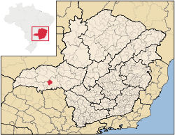
Veríssimo is located at an elevation of 674 meters, 43 km. west of Uberaba
Uberaba
Uberaba is a city and municipality in the west of the state of Minas Gerais in Brazil. Its population is 296.000 with an area of 4529.7 km², giving a density of 60.71 people per km². It is located on a plateau at an elevation of 785 meters and is in the Uberaba River floodplain...
. The distance to the state capital, Belo Horizonte
Belo Horizonte
Belo Horizonte is the capital of and largest city in the state of Minas Gerais, located in the southeastern region of Brazil. It is the third largest metropolitan area in the country...
, is 513 km. Neighboring municipalities are: Uberaba
Uberaba
Uberaba is a city and municipality in the west of the state of Minas Gerais in Brazil. Its population is 296.000 with an area of 4529.7 km², giving a density of 60.71 people per km². It is located on a plateau at an elevation of 785 meters and is in the Uberaba River floodplain...
, Conceição das Alagoas
Conceição das Alagoas
Conceição das Alagoas is a Brazilian municipality located in the west of the state of Minas Gerais. Its population as of 2007 was estimated to be 20,426 people living in a total area of 1,348 km². The city belongs to the mesoregion of Triângulo Mineiro and Alto Paranaíba and to the micro-region of...
, Campo Florido
Campo Florido
Campo Florido is a Brazilian municipality located in the west of the state of Minas Gerais. Its population as of 2007 was estimated to be 6,570 people living in a total area of 1,261 km². The city belongs to the mesoregion of Triângulo Mineiro and Alto Paranaíba and to the micro-region of Uberaba. ...
, Prata, and Uberlândia
Uberlândia
Uberlândia is the main town in the Triangle region, west of the state of Minas Gerais, Brazil. With a population of 604,013 inhabitants, according to 2010 estimates, the city is the second largest in the state second only to Belo Horizonte...
.
The main economic activities are services, small industries, and agriculture. The GDP in 2005 was approximately R$57 million, with 15 million Reais from services, 10 million Reais from industry, and 28 million Reais from agriculture. There were 516 rural producers on 76,000 hectares of land. The land is very fertile and agricultural production is high. 121 farms had tractors (2006). Approximately 1,100 persons were dependent on agriculture. The main crops were sugarcane and soybeans, but rubber, coffee, cotton, rice, beans and corn were also grown. There were 76,000 head of cattle (2006). There was 1 bank (2007) and 314 automobiles (165 motorcycles), giving a ratio of 11 inhabitants per automobile.
There was 1 health clinic. Patients with more serious health conditions are transported to Uberaba, which is connected by good roads. Educational needs were met by 3 primary schools, 1 middle school, and 2 pre-primary schools.
- Municipal Human Development IndexHuman Development IndexThe Human Development Index is a composite statistic used to rank countries by level of "human development" and separate "very high human development", "high human development", "medium human development", and "low human development" countries...
: 0.776 (2000) - State ranking: 133 out of 853 municipalities as of 2000
- National ranking: 1,164 out of 5,138 municipalities as of 2000
- Literacy rate: 85%
- Life expectancy: 74 (average of males and females)
In 2000 the per capita monthly income of R$244.00 was just below the state and national average of R$276.00 and R$297.00 respectively.
The highest ranking municipality in Minas Gerais in 2000 was Poços de Caldas
Poços de Caldas
Poços de Caldas is a city and municipality in south-western Minas Gerais state, Brazil, in the microregion of the same name. Its estimated population in 2009 was 151,449 inhabitants...
with 0.841, while the lowest was Setubinha
Setubinha
Setubinha is a municipality in the northeast of the Brazilian state of Minas Gerais. As of 2007 the population was 10,834 in a total area of 536 km². The elevation is 729 metres. It is part of the IBGE statistical microregion of Teófilo Otoni...
with 0.568. Nationally the highest was São Caetano do Sul
São Caetano do Sul
São Caetano do Sul is a city in São Paulo state in Brazil, located in the Greater São Paulo Metropolitan Area. It is the city with the highest per capita income in Brazil and it also has the highest Human Development Index .-Geography:São Caetano do Sul is located on a plateau that is part of the...
in São Paulo with 0.919, while the lowest was Setubinha. In more recent statistics (considering 5,507 municipalities) Manari in the state of Pernambuco
Pernambuco
Pernambuco is a state of Brazil, located in the Northeast region of the country. To the north are the states of Paraíba and Ceará, to the west is Piauí, to the south are Alagoas and Bahia, and to the east is the Atlantic Ocean. There are about of beaches, some of the most beautiful in the...
has the lowest rating in the country--0,467--putting it in last place.
See also
- List of municipalities in Minas Gerais