

Vardar
Encyclopedia

River
A river is a natural watercourse, usually freshwater, flowing towards an ocean, a lake, a sea, or another river. In a few cases, a river simply flows into the ground or dries up completely before reaching another body of water. Small rivers may also be called by several other names, including...
in the Republic of Macedonia
Republic of Macedonia
Macedonia , officially the Republic of Macedonia , is a country located in the central Balkan peninsula in Southeast Europe. It is one of the successor states of the former Yugoslavia, from which it declared independence in 1991...
and also a major river of Greece
Greece
Greece , officially the Hellenic Republic , and historically Hellas or the Republic of Greece in English, is a country in southeastern Europe....
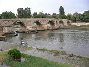
. It is 388 km (241 mi) long, and drains an area of around 25000 km² (9,653 sq mi). The maximum depth of river is 4 m (13 ft).
The river rises at Vrutok
Vrutok
Vrutok is a small village settled on the slopes of Mount Bistra by the Korab mountains, near the town of Gostivar in the western part of Republic of Macedonia. The village has around 1,200 inhabitants, of which 400 are Macedonian and 800 Albanian. Its importance belongs to the water streams where...
, a few kilometers north of Gostivar
Gostivar
Gostivar , is a city in the Republic of Macedonia, located in the upper Polog valley region. It is one of the largest municipalities in the country with a population of 81,042, and the town also covers . Gostivar has good road and railway connections with the other cities in the region, such as...
in the Republic of Macedonia. It passes through Gostivar
Gostivar
Gostivar , is a city in the Republic of Macedonia, located in the upper Polog valley region. It is one of the largest municipalities in the country with a population of 81,042, and the town also covers . Gostivar has good road and railway connections with the other cities in the region, such as...
, Skopje
Skopje
Skopje is the capital and largest city of the Republic of Macedonia with about a third of the total population. It is the country's political, cultural, economic, and academic centre...
and into Veles
Veles (city)
Veles is a city in the center of the Republic of Macedonia on the Vardar river. The city of Veles is the seat of Veles Municipality.-Name:The city's name was Vylosa in Ancient Greek and before the Balkan Wars, it was a township with the name Köprülü in the Üsküp sandjak, Ottoman empire for 600...
, crosses the Greek
Greece
Greece , officially the Hellenic Republic , and historically Hellas or the Republic of Greece in English, is a country in southeastern Europe....
border near Gevgelija
Gevgelija
Gevgelija is a town with a population of 15,685 located in the very southeast of the Republic of Macedonia along the banks of the Vardar River, situated at the country's main border with Greece , the point which links the motorway from Skopje and three other former Yugoslav capitals with...
, Polykastro
Polykastro
Polykastro , is a town and a former municipality in Kilkis regional unit, Greece. Since the 2011 local government reform it is part of the municipality Paionia, of which it is a municipal unit, and the seat. The municipal unit of Polykastro has 12,000 inhabitants, and includes Polykastro and 23...
and Axioupoli
Axioupoli
Axioupoli , known until 1927 as Boymitsa , is a small town and a former municipality in the former Paionia Province of Kilkis regional unit, Greece. Since the 2011 local government reform it is part of the municipality Paionia, of which it is a municipal unit...
("town on the Axiós"), before emptying into the Aegean Sea
Aegean Sea
The Aegean Sea[p] is an elongated embayment of the Mediterranean Sea located between the southern Balkan and Anatolian peninsulas, i.e., between the mainlands of Greece and Turkey. In the north, it is connected to the Marmara Sea and Black Sea by the Dardanelles and Bosporus...
in Central Macedonia
Central Macedonia
Central Macedonia is one of the thirteen regions of Greece, consisting of the central part of the region of Macedonia. With a population of over 1.8 million, it is the second most populous in Greece after Attica.- Administration :...
west of Thessaloniki
Thessaloniki
Thessaloniki , historically also known as Thessalonica, Salonika or Salonica, is the second-largest city in Greece and the capital of the region of Central Macedonia as well as the capital of the Decentralized Administration of Macedonia and Thrace...
in northern Greece.
The Vardar basin includes two-thirds of the territory of the Republic of Macedonia. The area is sometimes called "Vardar Macedonia
Vardar Macedonia
Vardar Macedonia is an area in the north of the Macedonia . The borders of the area are those of the Republic of Macedonia. It covers an area of...
" after the river, to distinguish it from "Aegean Macedonia" (in Greece) and "Pirin Macedonia" (in Bulgaria).
The valley comprises fertile lands in Polog, and Thessaloniki prefectures and Gevgelija and other parts. The river is surrounded by mountains elsewhere. The superhighways Greek National Road 1
Greek National Road 1
The Greek Motorway 1 is a motorway, partly under construction, and the 2nd longest in Greece. It is the principal north-south road connection in Greece, connecting the country's capital Athens with the regions of Thessaly and Macedonia, as well as the country's second largest city,...
in Greece and M1 and E75 run within the valley along the river's entire length to near Skopje.
The river is depicted on the coat of arms of Skopje, which in turn is incorporated in the city's flag.
Vardaris/Vardarec wind
The Vardaris or Vardarec is a powerful prevailing northerlyGeostrophic wind
The geostrophic wind is the theoretical wind that would result from an exact balance between the Coriolis effect and the pressure gradient force. This condition is called geostrophic balance. The geostrophic wind is directed parallel to isobars . This balance seldom holds exactly in nature...
ravine
Ravine
A ravine is a landform narrower than a canyon and is often the product of streamcutting erosion. Ravines are typically classified as larger in scale than gullies, although smaller than valleys. A ravine is generally a fluvial slope landform of relatively steep sides, on the order of twenty to...
wind which blows across the river valley in Greek Macedonia
Macedonia (Greece)
Macedonia is a geographical and historical region of Greece in Southern Europe. Macedonia is the largest and second most populous Greek region...
as well as in the Republic of Macedonia
Republic of Macedonia
Macedonia , officially the Republic of Macedonia , is a country located in the central Balkan peninsula in Southeast Europe. It is one of the successor states of the former Yugoslavia, from which it declared independence in 1991...
. At first it descends along the "canal" of the Vardar valley, usually as a breeze. When it encounters the high mountains that separate Greece from the Republic of Macedonia, it descends the other side, gathering a tremendous momentum and bringing cold conditions to the city of Thessaloniki
Thessaloniki
Thessaloniki , historically also known as Thessalonica, Salonika or Salonica, is the second-largest city in Greece and the capital of the region of Central Macedonia as well as the capital of the Decentralized Administration of Macedonia and Thrace...
and the Axios delta. Somewhat similar to the mistral
Mistral (wind)
The mistral is a strong, cold and usually dry regional wind in France, coming from the north or northwest, which accelerates when it passes through the valleys of the Rhone and the Durance Rivers to the coast of the Mediterranean around the Camargue region. It affects the northeast of the plain...
wind of France
France
The French Republic , The French Republic , The French Republic , (commonly known as France , is a unitary semi-presidential republic in Western Europe with several overseas territories and islands located on other continents and in the Indian, Pacific, and Atlantic oceans. Metropolitan France...
, it occurs when atmospheric pressure over eastern Europe is higher than over the Aegean Sea
Aegean Sea
The Aegean Sea[p] is an elongated embayment of the Mediterranean Sea located between the southern Balkan and Anatolian peninsulas, i.e., between the mainlands of Greece and Turkey. In the north, it is connected to the Marmara Sea and Black Sea by the Dardanelles and Bosporus...
, as is often the case in winter.
Etymology
- The most accepted theory on the origin of the name Vardar derives Bardários from the Thracian languageThracian languageThe Thracian language was the Indo-European language spoken in ancient times in Southeastern Europe by the Thracians, the northern neighbors of the Ancient Greeks. The Thracian language exhibits satemization: it either belonged to the Satem group of Indo-European languages or it was strongly...
, from PIEPieA pie is a baked dish which is usually made of a pastry dough casing that covers or completely contains a filling of various sweet or savoury ingredients....
*(s)wordo-wori- 'black water' (cf. GermanGerman languageGerman is a West Germanic language, related to and classified alongside English and Dutch. With an estimated 90 – 98 million native speakers, German is one of the world's major languages and is the most widely-spoken first language in the European Union....
schwarz 'black', LatinLatinLatin is an Italic language originally spoken in Latium and Ancient Rome. It, along with most European languages, is a descendant of the ancient Proto-Indo-European language. Although it is considered a dead language, a number of scholars and members of the Christian clergy speak it fluently, and...
suāsum 'dirt', Ossetian xuaræn 'color', PersianPersian languagePersian is an Iranian language within the Indo-Iranian branch of the Indo-European languages. It is primarily spoken in Iran, Afghanistan, Tajikistan and countries which historically came under Persian influence...
xvāl 'lampblack', Old Irish sorb 'stain, dirt'). This can be considered a translation or similar meaning of Axios, itself Thracian for 'not-shining' from PIE *n.-sk(e)i (cf. Avestan axšaēna 'dark-coloured'), and found in another name at the mouth of the Danube, Axíopa "dark water", renamed in Slavic Crna voda 'black water'. The name Bardários (Βαρδάριος) was sometimes used by the Ancient Greeks in the 3rd Century BCE; the same name was widely used during ByzantineByzantineByzantine usually refers to the Roman Empire during the Middle Ages.Byzantine may also refer to:* A citizen of the Byzantine Empire, or native Greek during the Middle Ages...
era.
In the Albanian language
Albanian language
Albanian is an Indo-European language spoken by approximately 7.6 million people, primarily in Albania and Kosovo but also in other areas of the Balkans in which there is an Albanian population, including western Macedonia, southern Montenegro, southern Serbia and northwestern Greece...
, the word "vardar" means a place where two creeks or rivers join together, or the joint flow of two rivers. The etymology of the word is unclear, although the Vardar river, in fact, has Lepenac as a major tributary.
- Its Greek name Axios (Αξιός) is mentioned by HomerHomerIn the Western classical tradition Homer , is the author of the Iliad and the Odyssey, and is revered as the greatest ancient Greek epic poet. These epics lie at the beginning of the Western canon of literature, and have had an enormous influence on the history of literature.When he lived is...
(Il. 21.141, Il. 2.849) as the home of the Paeonians, allies of TroyTroyTroy was a city, both factual and legendary, located in northwest Anatolia in what is now Turkey, southeast of the Dardanelles and beside Mount Ida...
.
External links
- Proceedings of the 1st Axios Catchment Consortium Meeting by the EUROPEAN COMMISSION - DG Research.
- PIM "Ivan Milutinović", Belgrade, Serbia ; Morava - Vardar (Axios) Navigation Route (About 1,200 km shorter route (three days shorter time of navigation) from BelgradeBelgradeBelgrade is the capital and largest city of Serbia. It is located at the confluence of the Sava and Danube rivers, where the Pannonian Plain meets the Balkans. According to official results of Census 2011, the city has a population of 1,639,121. It is one of the 15 largest cities in Europe...
to Port of Thessaloniki than across DanubeDanubeThe Danube is a river in the Central Europe and the Europe's second longest river after the Volga. It is classified as an international waterway....
, Black SeaBlack SeaThe Black Sea is bounded by Europe, Anatolia and the Caucasus and is ultimately connected to the Atlantic Ocean via the Mediterranean and the Aegean seas and various straits. The Bosphorus strait connects it to the Sea of Marmara, and the strait of the Dardanelles connects that sea to the Aegean...
and Agean Sea. Electric power production, improvement of water quality and regulation of flooding wave.) - Morava - Vardar (Axios) Navigation Route map
- Hydropower and navigation syustem "Morava" (Concepts of regulation of rivers Great Morava and South Morava for navigation and hydropower production.)