
Van Buren, Arkansas
Encyclopedia
Van Buren v is the second largest city in the Fort Smith, Arkansas
-Oklahoma
Metropolitan Statistical Area
and the county seat
of Crawford County, Arkansas
, United States
. The city is located directly northeast of Fort Smith
at the Interstate 40
- Interstate 540
junction. The city was incorporated in 1842 and according to 2010 Census Bureau estimates, the population of the city was 22,791, ranking it as the state's 19th largest city, behind Sherwood
.
in the community to serve as a fuel depot for river traffic. In the year 1831 a post office
was constructed for the community, at the time known as Phillips Landing. This post office was named after the newly appointed Secretary of State
, Martin Van Buren
.
John Drennen along with his partner, David Thompson, purchased the area for US$11,000. They moved their business of supplying firewood for steamboats to this new location on higher ground. The courthouse was constructed on a lot of land donated by Drennen on the condition that Van Buren become the county seat. The Drennen Reserve is one of the town's existing historical sites from the 1830s.
and Confederate
forces clashed along the Arkansas River
in and around the town of Van Buren resulting in a defeat for the Confederate army
driving them south across the river with minimal casualties, however the Union forces captured 100 prisoners, as stated in a battle report by Samuel R. Curtis, Major General of the Union forces.
The tornado, which spawned in Oklahoma
and crossed into west Fort Smith near the confluence of the Arkansas and Poteau Rivers, killed 2, injured 89 and cost $300 million in damage. The fatalities were small children from Ft. Smith. At its worst, the tornado was one half of one mile across. After leaving the downtown area of Fort Smith, it traveled northwest through industrial and residential sections of north Fort Smith, then crossed the Arkansas River
again into the Mount Vista area on the west side of Van Buren and damaged a highly residential area where no fatalities occurred although this area was very populated at the time. The total length it traveled on the ground was 7 miles. In total, there were around 1,800 homes damaged the majority of which were in Van Buren.
According to the United States Census Bureau
, the city has a total area of 15.9 square miles (41.2 km²), 15.1 square miles (39.1 km²) of which is land and 0.8 square miles (2.1 km²) (5.05%) is water.
Along the southern side, the Arkansas River
separates Van Buren from Fort Smith of Sebastian County. Lee Creek
runs along the western side of city where it eventually flows into the Arkansas River.
. Average temperatures range from 36°F in January, to as high an average of 81°F in July with temperatures reaching the high 90s and low 100s in August. The average annual temperature is approximately 60°F. Average precipitation
is about 41 total inches, with only six inches being snow.
of 2000, there were 18,986 people, 6,947 households, and 5,182 families residing in the city. The population density
was 1,260.7 people per square mile (486.8/km²). There were 7,427 housing units at an average density of 493.2 per square mile (190.4/km²). The racial makeup of the city was 87.37% White
, 1.64% Black
or African American
, 1.96% Native American
, 2.82% Asian
, 3.17% from other races
, and 3.03% from two or more races. 6.04% of the population were Hispanic
or Latino
of any race.
There are 6,947 households, of which 40.4% have children under the age of 18 living with them, 56.2% were married couples
living together, 14.7% had a female householder with no husband present, and 25.4% are classified as non-families by the United States Census Bureau
.
Of 6,947 households, 362 are unmarried partner households: 304 heterosexual, 12 same-sex male, and 46 same-sex female households. 21.7% of all households were made up of individuals and 8.2% had someone living alone who was 65 years of age or older. The average household size was 2.67 and the average family size was 3.12.
In the city the population was spread out with 29.6% under the age of 18, 9.0% from 18 to 24, 30.7% from 25 to 44, 20.1% from 45 to 64, and 10.6% who were 65 years of age or older. The median age was 33 years. For every 100 females there were 92.0 males. For every 100 females age 18 and over, there were 86.8 males.
The median income for a household in the city was $33,608, and the median income for a family was $37,198. Males had a median income of $28,798 versus $21,201 for females. The per capita income
for the city was $14,948. About 13.5% of families and 16.7% of the population were below the poverty line, including 24.4% of those under age 18 and 13.0% of those age 65 or over.
, a Victorian
-style performance hall from the late 19th century, part of the old downtown historic area. At the south end of the historical downtown is the Crawford County courthouse, the oldest functioning courthouse west of the Mississippi River
. To the north is the Old Frisco Station which was originally a station on the St. Louis-San Francisco Railway
, pictured at the top of this page.
based television stations including KHBS
and KFSM
, whose radio mast is built in Van Buren, provide local news and weather.
The city's major newspaper is the Van Buren Press Argus-Courier, however many people also read Fort Smith's Southwest Times Record, as well as the Northwest Edition of the Arkansas Democrat-Gazette
.
, Interstate 540 (Arkansas)
, and the Arkansas
/Oklahoma
border yields surprisingly large tourism and hospitality industries. The city is also located at the junction of several state and U.S. highways
including Arkansas Highway 59, US 64, and US 71. A private airport, Twin Cities Airport (code 39AR), was operational to the southeast of the city, but has been closed for many years. Modern railroads in the city include the Arkansas and Missouri Railroad
and the Union Pacific Railroad
.
(grades K-4), two middle school
s (grades 5-6), two junior highs (grades 7-9) and one high school (grades 10-12). The Van Buren High School is in the 7A-Central Division of Arkansas high school sports.
Fort Smith, Arkansas
Fort Smith is the second-largest city in Arkansas and one of the two county seats of Sebastian County. With a population of 86,209 in 2010, it is the principal city of the Fort Smith, Arkansas-Oklahoma Metropolitan Statistical Area, a region of 298,592 residents which encompasses the Arkansas...
-Oklahoma
Oklahoma
Oklahoma is a state located in the South Central region of the United States of America. With an estimated 3,751,351 residents as of the 2010 census and a land area of 68,667 square miles , Oklahoma is the 28th most populous and 20th-largest state...
Metropolitan Statistical Area
Fort Smith metropolitan area
The Fort Smith Metropolitan Statistical Area, as defined by the United States Census Bureau, is a five-county area including three Arkansas counties and two Oklahoma counties, and anchored by the city of Fort Smith, Arkansas...
and the county seat
County seat
A county seat is an administrative center, or seat of government, for a county or civil parish. The term is primarily used in the United States....
of Crawford County, Arkansas
Arkansas
Arkansas is a state located in the southern region of the United States. Its name is an Algonquian name of the Quapaw Indians. Arkansas shares borders with six states , and its eastern border is largely defined by the Mississippi River...
, United States
United States
The United States of America is a federal constitutional republic comprising fifty states and a federal district...
. The city is located directly northeast of Fort Smith
Fort Smith, Arkansas
Fort Smith is the second-largest city in Arkansas and one of the two county seats of Sebastian County. With a population of 86,209 in 2010, it is the principal city of the Fort Smith, Arkansas-Oklahoma Metropolitan Statistical Area, a region of 298,592 residents which encompasses the Arkansas...
at the Interstate 40
Interstate 40
Interstate 40 is the third-longest major east–west Interstate Highway in the United States, after I-90 and I-80. Its western end is at Interstate 15 in Barstow, California; its eastern end is at a concurrency of U.S. Route 117 and North Carolina Highway 132 in Wilmington, North Carolina...
- Interstate 540
Interstate 540 (Arkansas)
Interstate 540 in Arkansas is a spur of Interstate 40 between Fort Smith and Northwest Arkansas; the Northwest Arkansas segment is proposed to become part of an expanded Interstate 49. I-540 provides an Interstate Highway path between Fayetteville and Little Rock via Interstate 40. This links the...
junction. The city was incorporated in 1842 and according to 2010 Census Bureau estimates, the population of the city was 22,791, ranking it as the state's 19th largest city, behind Sherwood
Sherwood, Arkansas
Sherwood is a city in Pulaski County, Arkansas, United States, and a suburb of Little Rock. As of the 2010 census, the population of the city was 29,523...
.
Phillips Landing and earlier
The area was settled by David Boyd and Thomas Martin in the year 1818. After Arkansas became a territory in 1819 Daniel and Thomas Phillips constructed a lumber yardLumber yard
A lumber yard is a retail location for lumber and wood related products used in construction and/or home improvement projects. Lumber yards can also provide services such as the use of a planer and other large machines....
in the community to serve as a fuel depot for river traffic. In the year 1831 a post office
Post office
A post office is a facility forming part of a postal system for the posting, receipt, sorting, handling, transmission or delivery of mail.Post offices offer mail-related services such as post office boxes, postage and packaging supplies...
was constructed for the community, at the time known as Phillips Landing. This post office was named after the newly appointed Secretary of State
United States Secretary of State
The United States Secretary of State is the head of the United States Department of State, concerned with foreign affairs. The Secretary is a member of the Cabinet and the highest-ranking cabinet secretary both in line of succession and order of precedence...
, Martin Van Buren
Martin Van Buren
Martin Van Buren was the eighth President of the United States . Before his presidency, he was the eighth Vice President and the tenth Secretary of State, under Andrew Jackson ....
.
John Drennen along with his partner, David Thompson, purchased the area for US$11,000. They moved their business of supplying firewood for steamboats to this new location on higher ground. The courthouse was constructed on a lot of land donated by Drennen on the condition that Van Buren become the county seat. The Drennen Reserve is one of the town's existing historical sites from the 1830s.
Battle of Van Buren, 1862
On December 7, 1862, UnionUnion (American Civil War)
During the American Civil War, the Union was a name used to refer to the federal government of the United States, which was supported by the twenty free states and five border slave states. It was opposed by 11 southern slave states that had declared a secession to join together to form the...
and Confederate
Confederate States of America
The Confederate States of America was a government set up from 1861 to 1865 by 11 Southern slave states of the United States of America that had declared their secession from the U.S...
forces clashed along the Arkansas River
Arkansas River
The Arkansas River is a major tributary of the Mississippi River. The Arkansas generally flows to the east and southeast as it traverses the U.S. states of Colorado, Kansas, Oklahoma, and Arkansas. The river's initial basin starts in the Western United States in Colorado, specifically the Arkansas...
in and around the town of Van Buren resulting in a defeat for the Confederate army
Confederate States Army
The Confederate States Army was the army of the Confederate States of America while the Confederacy existed during the American Civil War. On February 8, 1861, delegates from the seven Deep South states which had already declared their secession from the United States of America adopted the...
driving them south across the river with minimal casualties, however the Union forces captured 100 prisoners, as stated in a battle report by Samuel R. Curtis, Major General of the Union forces.
1996 tornado
On April 21, 1996 at 11:12 p.m., a category F3 tornado hit the Fort Smith/Van Buren area causing extensive damage.The tornado, which spawned in Oklahoma
Oklahoma
Oklahoma is a state located in the South Central region of the United States of America. With an estimated 3,751,351 residents as of the 2010 census and a land area of 68,667 square miles , Oklahoma is the 28th most populous and 20th-largest state...
and crossed into west Fort Smith near the confluence of the Arkansas and Poteau Rivers, killed 2, injured 89 and cost $300 million in damage. The fatalities were small children from Ft. Smith. At its worst, the tornado was one half of one mile across. After leaving the downtown area of Fort Smith, it traveled northwest through industrial and residential sections of north Fort Smith, then crossed the Arkansas River
Arkansas River
The Arkansas River is a major tributary of the Mississippi River. The Arkansas generally flows to the east and southeast as it traverses the U.S. states of Colorado, Kansas, Oklahoma, and Arkansas. The river's initial basin starts in the Western United States in Colorado, specifically the Arkansas...
again into the Mount Vista area on the west side of Van Buren and damaged a highly residential area where no fatalities occurred although this area was very populated at the time. The total length it traveled on the ground was 7 miles. In total, there were around 1,800 homes damaged the majority of which were in Van Buren.
Physical geography
Van Buren is located at 35°26′40"N 94°20′48"W (35.444339, -94.346737).According to the United States Census Bureau
United States Census Bureau
The United States Census Bureau is the government agency that is responsible for the United States Census. It also gathers other national demographic and economic data...
, the city has a total area of 15.9 square miles (41.2 km²), 15.1 square miles (39.1 km²) of which is land and 0.8 square miles (2.1 km²) (5.05%) is water.
Along the southern side, the Arkansas River
Arkansas River
The Arkansas River is a major tributary of the Mississippi River. The Arkansas generally flows to the east and southeast as it traverses the U.S. states of Colorado, Kansas, Oklahoma, and Arkansas. The river's initial basin starts in the Western United States in Colorado, specifically the Arkansas...
separates Van Buren from Fort Smith of Sebastian County. Lee Creek
Lee Creek (Arkansas)
Lee Creek is a river in Arkansas and Oklahoma which starts near West Fork in Washington County, Arkansas and flows south to the Arkansas River passing through Crawford County, Arkansas and Sequoyah County, Oklahoma...
runs along the western side of city where it eventually flows into the Arkansas River.
Climate
Van Buren lies within a humid subtropical climate area. The city also lies on the eastern edge of the region known as Tornado AlleyTornado Alley
Tornado Alley is a colloquial and popular media term that most often refers to the area of the United States where tornadoes are most frequent. Although an official location is not defined, the area between the Rocky Mountains and Appalachian Mountains is usually associated with it.The areas...
. Average temperatures range from 36°F in January, to as high an average of 81°F in July with temperatures reaching the high 90s and low 100s in August. The average annual temperature is approximately 60°F. Average precipitation
Precipitation (meteorology)
In meteorology, precipitation In meteorology, precipitation In meteorology, precipitation (also known as one of the classes of hydrometeors, which are atmospheric water phenomena is any product of the condensation of atmospheric water vapor that falls under gravity. The main forms of precipitation...
is about 41 total inches, with only six inches being snow.
Demographics
As of the censusCensus
A census is the procedure of systematically acquiring and recording information about the members of a given population. It is a regularly occurring and official count of a particular population. The term is used mostly in connection with national population and housing censuses; other common...
of 2000, there were 18,986 people, 6,947 households, and 5,182 families residing in the city. The population density
Population density
Population density is a measurement of population per unit area or unit volume. It is frequently applied to living organisms, and particularly to humans...
was 1,260.7 people per square mile (486.8/km²). There were 7,427 housing units at an average density of 493.2 per square mile (190.4/km²). The racial makeup of the city was 87.37% White
Race (United States Census)
Race and ethnicity in the United States Census, as defined by the Federal Office of Management and Budget and the United States Census Bureau, are self-identification data items in which residents choose the race or races with which they most closely identify, and indicate whether or not they are...
, 1.64% Black
Race (United States Census)
Race and ethnicity in the United States Census, as defined by the Federal Office of Management and Budget and the United States Census Bureau, are self-identification data items in which residents choose the race or races with which they most closely identify, and indicate whether or not they are...
or African American
Race (United States Census)
Race and ethnicity in the United States Census, as defined by the Federal Office of Management and Budget and the United States Census Bureau, are self-identification data items in which residents choose the race or races with which they most closely identify, and indicate whether or not they are...
, 1.96% Native American
Race (United States Census)
Race and ethnicity in the United States Census, as defined by the Federal Office of Management and Budget and the United States Census Bureau, are self-identification data items in which residents choose the race or races with which they most closely identify, and indicate whether or not they are...
, 2.82% Asian
Race (United States Census)
Race and ethnicity in the United States Census, as defined by the Federal Office of Management and Budget and the United States Census Bureau, are self-identification data items in which residents choose the race or races with which they most closely identify, and indicate whether or not they are...
, 3.17% from other races
Race (United States Census)
Race and ethnicity in the United States Census, as defined by the Federal Office of Management and Budget and the United States Census Bureau, are self-identification data items in which residents choose the race or races with which they most closely identify, and indicate whether or not they are...
, and 3.03% from two or more races. 6.04% of the population were Hispanic
Race (United States Census)
Race and ethnicity in the United States Census, as defined by the Federal Office of Management and Budget and the United States Census Bureau, are self-identification data items in which residents choose the race or races with which they most closely identify, and indicate whether or not they are...
or Latino
Race (United States Census)
Race and ethnicity in the United States Census, as defined by the Federal Office of Management and Budget and the United States Census Bureau, are self-identification data items in which residents choose the race or races with which they most closely identify, and indicate whether or not they are...
of any race.
There are 6,947 households, of which 40.4% have children under the age of 18 living with them, 56.2% were married couples
Marriage
Marriage is a social union or legal contract between people that creates kinship. It is an institution in which interpersonal relationships, usually intimate and sexual, are acknowledged in a variety of ways, depending on the culture or subculture in which it is found...
living together, 14.7% had a female householder with no husband present, and 25.4% are classified as non-families by the United States Census Bureau
United States Census Bureau
The United States Census Bureau is the government agency that is responsible for the United States Census. It also gathers other national demographic and economic data...
.
Of 6,947 households, 362 are unmarried partner households: 304 heterosexual, 12 same-sex male, and 46 same-sex female households. 21.7% of all households were made up of individuals and 8.2% had someone living alone who was 65 years of age or older. The average household size was 2.67 and the average family size was 3.12.
In the city the population was spread out with 29.6% under the age of 18, 9.0% from 18 to 24, 30.7% from 25 to 44, 20.1% from 45 to 64, and 10.6% who were 65 years of age or older. The median age was 33 years. For every 100 females there were 92.0 males. For every 100 females age 18 and over, there were 86.8 males.
The median income for a household in the city was $33,608, and the median income for a family was $37,198. Males had a median income of $28,798 versus $21,201 for females. The per capita income
Per capita income
Per capita income or income per person is a measure of mean income within an economic aggregate, such as a country or city. It is calculated by taking a measure of all sources of income in the aggregate and dividing it by the total population...
for the city was $14,948. About 13.5% of families and 16.7% of the population were below the poverty line, including 24.4% of those under age 18 and 13.0% of those age 65 or over.
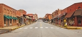
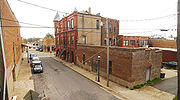
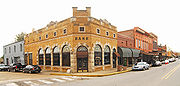
Arts and architecture
Van Buren is home of the King Opera HouseKing Opera House
The King Opera House is a performance hall and historic landmark located on Van Buren, Arkansas' Main Street. Since it was built in the late 19th century, the opera house's stage has hosted many plays and performers.-Building Style:...
, a Victorian
Victorian architecture
The term Victorian architecture refers collectively to several architectural styles employed predominantly during the middle and late 19th century. The period that it indicates may slightly overlap the actual reign, 20 June 1837 – 22 January 1901, of Queen Victoria. This represents the British and...
-style performance hall from the late 19th century, part of the old downtown historic area. At the south end of the historical downtown is the Crawford County courthouse, the oldest functioning courthouse west of the Mississippi River
Mississippi River
The Mississippi River is the largest river system in North America. Flowing entirely in the United States, this river rises in western Minnesota and meanders slowly southwards for to the Mississippi River Delta at the Gulf of Mexico. With its many tributaries, the Mississippi's watershed drains...
. To the north is the Old Frisco Station which was originally a station on the St. Louis-San Francisco Railway
St. Louis-San Francisco Railway
The St. Louis – San Francisco Railway , also known as the Frisco, was a railroad that operated in the Midwest and South Central U.S. from 1876 to 1980.-History:...
, pictured at the top of this page.
Media
As part of the primary Fort Smith metropolitan area, many Fort SmithFort Smith, Arkansas
Fort Smith is the second-largest city in Arkansas and one of the two county seats of Sebastian County. With a population of 86,209 in 2010, it is the principal city of the Fort Smith, Arkansas-Oklahoma Metropolitan Statistical Area, a region of 298,592 residents which encompasses the Arkansas...
based television stations including KHBS
KHBS
KHBS, virtual channel 40 in Fort Smith and KHOG, virtual channel 29 in Fayetteville are the ABC-affiliated television stations for the Fort Smith/Fayetteville, Arkansas television market. The KHBS transmitter is located northwest of Poteau, Oklahoma. The KHOG transmitter is located southeast of...
and KFSM
KFSM-TV
KFSM-TV is the CBS-affiliated television station for the Arkansas River Valley and Northwest Arkansas that is licensed to Fort Smith. It broadcasts a high definition digital signal on UHF channel 18 from a transmitter northwest of Winslow. Owned by Local TV, the station has studios on North 13th...
, whose radio mast is built in Van Buren, provide local news and weather.
The city's major newspaper is the Van Buren Press Argus-Courier, however many people also read Fort Smith's Southwest Times Record, as well as the Northwest Edition of the Arkansas Democrat-Gazette
Arkansas Democrat-Gazette
The Arkansas Democrat-Gazette is the newspaper of record in the U.S. state of Arkansas, printed in Little Rock with a northwest edition published in Lowell...
.
Transportation
Van Buren's location at the junction of Interstate 40Interstate 40
Interstate 40 is the third-longest major east–west Interstate Highway in the United States, after I-90 and I-80. Its western end is at Interstate 15 in Barstow, California; its eastern end is at a concurrency of U.S. Route 117 and North Carolina Highway 132 in Wilmington, North Carolina...
, Interstate 540 (Arkansas)
Interstate 540 (Arkansas)
Interstate 540 in Arkansas is a spur of Interstate 40 between Fort Smith and Northwest Arkansas; the Northwest Arkansas segment is proposed to become part of an expanded Interstate 49. I-540 provides an Interstate Highway path between Fayetteville and Little Rock via Interstate 40. This links the...
, and the Arkansas
Arkansas
Arkansas is a state located in the southern region of the United States. Its name is an Algonquian name of the Quapaw Indians. Arkansas shares borders with six states , and its eastern border is largely defined by the Mississippi River...
/Oklahoma
Oklahoma
Oklahoma is a state located in the South Central region of the United States of America. With an estimated 3,751,351 residents as of the 2010 census and a land area of 68,667 square miles , Oklahoma is the 28th most populous and 20th-largest state...
border yields surprisingly large tourism and hospitality industries. The city is also located at the junction of several state and U.S. highways
United States Numbered Highways
The system of United States Numbered Highways is an integrated system of roads and highways in the United States numbered within a nationwide grid...
including Arkansas Highway 59, US 64, and US 71. A private airport, Twin Cities Airport (code 39AR), was operational to the southeast of the city, but has been closed for many years. Modern railroads in the city include the Arkansas and Missouri Railroad
Arkansas and Missouri Railroad
The Arkansas and Missouri Railroad is a short-line railroad headquartered in Springdale, Arkansas.The A & M, as it is known, operates of line from Fort Smith, Arkansas to Monett, Missouri. The railroad interchanges freight cars with Kansas City Southern Railway at Fort Smith, with Union Pacific...
and the Union Pacific Railroad
Union Pacific Railroad
The Union Pacific Railroad , headquartered in Omaha, Nebraska, is the largest railroad network in the United States. James R. Young is president, CEO and Chairman....
.
Education
The Van Buren School District is the largest school district in Crawford County, consisting of six elementary schoolsPrimary education
A primary school is an institution in which children receive the first stage of compulsory education known as primary or elementary education. Primary school is the preferred term in the United Kingdom and many Commonwealth Nations, and in most publications of the United Nations Educational,...
(grades K-4), two middle school
Middle school
Middle School and Junior High School are levels of schooling between elementary and high schools. Most school systems use one term or the other, not both. The terms are not interchangeable...
s (grades 5-6), two junior highs (grades 7-9) and one high school (grades 10-12). The Van Buren High School is in the 7A-Central Division of Arkansas high school sports.
Sites of interest
- King Opera HouseKing Opera HouseThe King Opera House is a performance hall and historic landmark located on Van Buren, Arkansas' Main Street. Since it was built in the late 19th century, the opera house's stage has hosted many plays and performers.-Building Style:...
-Performance hall and historic landmark. - The Old Frisco Station-Victorian style railroad station; used for a scene in the film Biloxi BluesBiloxi BluesBiloxi Blues is a semi-autobiographical play by Neil Simon. The second chapter in what is known as his Eugene trilogy, it follows Brighton Beach Memoirs and precedes Broadway Bound....
. It was part of the now defunct St. Louis-San Francisco RailwaySt. Louis-San Francisco RailwayThe St. Louis – San Francisco Railway , also known as the Frisco, was a railroad that operated in the Midwest and South Central U.S. from 1876 to 1980.-History:...
also known as the Frisco. - Historic Main Street - was used for scenes in the film The Blue and the GrayThe Blue and the GrayThe Blue and the Gray is a television miniseries that first aired on CBS in three installments on November 14, November 16, and November 17, 1982. Set during the American Civil War, the series starred John Hammond, Stacy Keach, Lloyd Bridges, and Gregory Peck as President Abraham Lincoln...
.
Notable natives
- Bob Burns - Comedian and actor
- John T. DeweeseJohn T. DeweeseJohn Thomas Deweese was a Congressional Representative from North Carolina.-Biography:Born in Van Buren, Arkansas, June 4, 1835; educated at home; studied law; was admitted to the bar in 1856 and commenced practice in Henderson, Kentucky; resident of Denver, Colorado, for some years; moved to Pike...
- U.S. Representative from North Carolina - Matt Jones (American football)Matt Jones (American football)Matthew Jones is a former American football wide receiver . He was drafted by the Jacksonville Jaguars in the first round of the 2005 NFL Draft, and retired officially in November 2010. He played college football at Arkansas....
- National Football LeagueNational Football LeagueThe National Football League is the highest level of professional American football in the United States, and is considered the top professional American football league in the world. It was formed by eleven teams in 1920 as the American Professional Football Association, with the league changing...
player - Natalie White - Survivor Samoa winner