
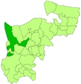
Uxbridge Rural District
Encyclopedia
Uxbridge was, from 1875 to 1925, a local government district in Middlesex
, England
.
The district was formed as a rural sanitary district
in 1875. It was based on the existing poor
Uxbridge
Poor Law Union
, except for Uxbridge, to the west, which was an urban sanitary district. Part of the Hillingdon
parish was added to Uxbridge USD in 1883. The parish of Norwood was removed in 1891, forming an urban sanitary district.
Under the Local Government Act 1894
it became a rural district
, with a directly elected rural district council. The Hillingdon parish was split, with Hillingon West being formed from the part in Uxbridge urban district and Hillingdon East being the part in the rural district.
As of 1894, the district included the parishes of
A further parish, Yiewsley
, was created in 1896 from part of the Hillingdon East parish.
Hayes became an urban district
in 1904, as did Ruislip (under the name Ruislip-Northwood
). Northolt was split in 1928 between the Municipal Borough of Ealing
and Harrow on the Hill Urban District
. A Yiewsley Urban District
was created in 1911.
The district was finally abolished in 1929, becoming part of the Uxbridge Urban District
, apart from the parish of West Drayton which became part of the renamed Yiewsley and West Drayton Urban District. Most of the area now forms part of the London Borough of Hillingdon
, with the former parish of Northolt split between the London Borough of Ealing
and the London Borough of Brent
.
Middlesex
Middlesex is one of the historic counties of England and the second smallest by area. The low-lying county contained the wealthy and politically independent City of London on its southern boundary and was dominated by it from a very early time...
, England
England
England is a country that is part of the United Kingdom. It shares land borders with Scotland to the north and Wales to the west; the Irish Sea is to the north west, the Celtic Sea to the south west, with the North Sea to the east and the English Channel to the south separating it from continental...
.
The district was formed as a rural sanitary district
Sanitary district
Sanitary districts were established in England and Wales in 1875 and in Ireland in 1878. The districts were of two types, based on existing structures:*Urban sanitary districts in towns with existing local government bodies...
in 1875. It was based on the existing poor
Poor Law
The English Poor Laws were a system of poor relief which existed in England and Wales that developed out of late-medieval and Tudor-era laws before being codified in 1587–98...
Uxbridge
Uxbridge
Uxbridge is a large town located in north west London, England and is the administrative headquarters of the London Borough of Hillingdon. It forms part of the ceremonial county of Greater London. It is located west-northwest of Charing Cross and is one of the major metropolitan centres...
Poor Law Union
Poor Law Union
A Poor Law Union was a unit used for local government in the United Kingdom from the 19th century. The administration of the Poor Law was the responsibility of parishes, which varied wildly in their size, populations, financial resources, rateable values and requirements...
, except for Uxbridge, to the west, which was an urban sanitary district. Part of the Hillingdon
Hillingdon
Hillingdon is a suburban area within the London Borough of Hillingdon, situated 14.2 miles west of Charing Cross.Much of Hillingdon is represented as the Hillingdon East ward within the local authority, Hillingdon Council...
parish was added to Uxbridge USD in 1883. The parish of Norwood was removed in 1891, forming an urban sanitary district.
Under the Local Government Act 1894
Local Government Act 1894
The Local Government Act 1894 was an Act of the Parliament of the United Kingdom that reformed local government in England and Wales outside the County of London. The Act followed the reforms carried out at county level under the Local Government Act 1888...
it became a rural district
Rural district
Rural districts were a type of local government area – now superseded – established at the end of the 19th century in England, Wales, and Ireland for the administration of predominantly rural areas at a level lower than that of the administrative counties.-England and Wales:In England...
, with a directly elected rural district council. The Hillingdon parish was split, with Hillingon West being formed from the part in Uxbridge urban district and Hillingdon East being the part in the rural district.
As of 1894, the district included the parishes of
- CowleyCowley, LondonCowley is a place in the London Borough of Hillingdon. It is a suburban development situated 15.4 miles west of Charing Cross. Cowley is home to , which was mentioned in the 1086 Domesday Book....
- HarefieldHarefieldHarefield is a village in the London Borough of Hillingdon in northwest London, England. It is situated on top of a hill, northwest of Charing Cross, near the Greater London boundary with Buckinghamshire to the west and Hertfordshire to the north...
- HayesHayes, HillingdonHayes is a town in the London Borough of Hillingdon, West London. It is a suburban development situated west of Charing Cross. Hayes was developed in the late 19th and 20th centuries as an industrial locality to which residential districts were later added in order to house factory workers...
- Hillingdon East
- IckenhamIckenhamIckenham is a suburban area centred on an old village in Greater London, part of the London Borough of Hillingdon.While no major historical events have taken place in Ickenham, settlements dating back to the Roman occupation of Britain have been discovered during archaeological surveys, and the...
- NortholtNortholtNortholt is a town in the London Borough of Ealing, England. The town has London Underground and Network Rail stations and is on the A40 road...
- RuislipRuislipRuislip is a suburban area, centred on an old village in Greater London, and is part of the London Borough of Hillingdon.It was formerly also a parish covering the neighbouring areas of Eastcote, Northwood, Ruislip Manor and South Ruislip in the area. The parish appears in the Domesday Book, and...
- West DraytonWest DraytonWest Drayton is a suburban area in the London Borough of Hillingdon in the far west of London, England. Formerly part of the Yiewsley and West Drayton Urban District of Middlesex, the district became part of Greater London in 1965....
A further parish, Yiewsley
Yiewsley
Yiewsley is a place in the London Borough of Hillingdon. Its name derives from the Anglo-Saxon Wifeleslēah: "Wifel's woodland clearing".The nearest places to Yiewsley are Hayes, Harlington, Cowley, Harmondsworth, Sipson, and West Drayton....
, was created in 1896 from part of the Hillingdon East parish.
Hayes became an urban district
Urban district
In the England, Wales and Ireland, an urban district was a type of local government district that covered an urbanised area. Urban districts had an elected Urban District Council , which shared local government responsibilities with a county council....
in 1904, as did Ruislip (under the name Ruislip-Northwood
Ruislip-Northwood Urban District
Ruislip-Northwood was an urban district in west Middlesex, England, from 1904 to 1965. From its inception Ruislip-Northwood fell within the Metropolitan Police District and from 1933 it was part of the London Passenger Transport Area....
). Northolt was split in 1928 between the Municipal Borough of Ealing
Municipal Borough of Ealing
Ealing was a local government district from 1863 to 1965 around the town of Ealing.A local board of health was formed for the southern part of the parish of Ealing, Middlesex, in 1863. In 1873 the board's area was extended to the rest of the parish....
and Harrow on the Hill Urban District
Harrow on the Hill Urban District
Harrow on the Hill was an urban district in Middlesex, England from 1894 to 1934.It was created under the Local Government Act 1894. This Act split the historic parish of Harrow on the Hill several ways, with parts becoming the new parishes of Harrow Weald, Wealdstone and Wembley...
. A Yiewsley Urban District
Yiewsley and West Drayton Urban District
Yiewsley and West Drayton was an urban district in Middlesex, England.It was formed in 1911 from the parish of Yiewsley, formerly part of Uxbridge Rural District. This rural district was abolished in 1929, and Yiewsley was joined by the parish of West Drayton, resulting in a change of name for the...
was created in 1911.
The district was finally abolished in 1929, becoming part of the Uxbridge Urban District
Municipal Borough of Uxbridge
Uxbridge was a local government district in north west Middlesex, England, from 1849 to 1965, based around the town of Uxbridge.Uxbridge was one of the first towns in England to adopt the Public Health Act 1848 in 1849 and form a local board of health. Under the Local Government Act 1894 the local...
, apart from the parish of West Drayton which became part of the renamed Yiewsley and West Drayton Urban District. Most of the area now forms part of the London Borough of Hillingdon
London Borough of Hillingdon
The London Borough of Hillingdon is the westernmost borough in Greater London, England. The borough's population was recorded as 243,006 in the 2001 Census. The borough incorporates the former districts of Ruislip-Northwood, Uxbridge, Hayes and Harlington and Yiewsley and West Drayton in the...
, with the former parish of Northolt split between the London Borough of Ealing
London Borough of Ealing
The London Borough of Ealing is a borough in west London.-Location:The London Borough of Ealing borders the London Borough of Hillingdon to the west, the London Borough of Harrow and the London Borough of Brent to the north, the London Borough of Hammersmith and Fulham to the east and the London...
and the London Borough of Brent
London Borough of Brent
In 1801, the civil parishes that form the modern borough had a total population of 2,022. This rose slowly throughout the 19th century, as the district became built up; reaching 5,646 in the middle of the century. When the railways arrived the rate of population growth increased...
.