

Uttaradit Province
Encyclopedia
Uttaradit is one of the northern provinces
(changwat) of Thailand
. Neighboring provinces are (from south clockwise) Phitsanulok
, Sukhothai
, Phrae
and Nan
. To the east it borders Xaignabouli of Laos
.
.
In the Sukhothai era
several city states (Mueang
) subject to the king were located in the area of the modern province. Mueang Fang was in modern day Mueang Uttaradit district, Mueng Thung Yang in Laplae, and Mueang Ta Chuchok in Tron district.
During the Ayutthaya kingdom
, Mueang Phichai was one of the 16 main Mueang of the Thai kingdom. In the reign of King Naresuan
, the ruler of Phichai rebelled, joined by the ruler of Sawankhalok. Their revolt was suppressed and the inhabitants of both cities were forced to move south to Phitsanulok.
Following the fall of the city of Ayutthaya to the Burmese in 1767, Phichai was the site of several battles against the invaders. The ruler of Phichai succeeded in driving back the Burmese and was awarded the title Phraya Phichai Dabhak - the "Lord of Pichai with a Broken Sword", as he had broken one of his swords in fierce hand to hand combat with the enemy.
In the reign of King Rama III Mueang Phichai controlled several Mueang of northern Siam like Nan or Phrae, and even Luang Prabang and Vientiane. At the point where the Nan river became shallow a port was established. As this town grew in importance as an important trade point, in 1887 it was made a Mueang subordinate of Phichai. 1899 the center of Phichai was moved to this new location, which was renamed to Uttaradit in 1915.
 The province is located in the valley of the Nan River
. About 45 kilometers north of the city Uttaradit is the Queen Sirikit Dam
, which created a 250 km² artificial lake from the Nan.
Most of the province was once covered with teak
forests, then the major product of Uttaradit. The largest Teak tree in the world is found at the Ton Sak Yai Park. The 1500 year old tree measures 9.87 m in circumference and 37 m in height - originally it was 48.5 m high, but it was damaged in a storm.
Three National Parks are located in the province—Klong Tron, Lam Nam Nan and Phu Soi Dao.
shows the mondop at the temple Wat Phra Thaen Sila At, in Baan Phra Thaen in the Laplae district. The main item of worship in the temple is a laterite
block, which is believed to have been used by Buddha
to seek enlightenment. The mondhop is built upon this block.
The seal was first designed in 1940, later a garuda
as the symbol of Thailand and the name of the province were added.
The provincial tree is the Teak
(Tectona grandis).
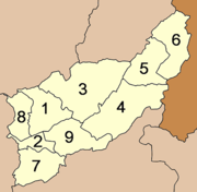 The province is subdivided in 9 districts (amphoe
). These are further subdivided into 67 communes (tambon
) and 562 villages (muban
).
. Beside the Railway, you can access Uttaradit by driving a car, riding a bus from Bus Terminal of Thailand. Also you may travel by a plane to reach Phitsanulok which is the nearest airport.
and is consisted of various unsorted woods. Most important of all this Botanical forest has a biggest teak tree in the world, it has a height of 47 meters and the circumference of the tree stem is measured to be 9.58 m. It is about 1,500 years old by comparison of the size and the number of years from the teak stumps in nearby area. At present there is a height of about 37 meters left because the top of the tree was broken by strong wind, but the stem in general is still left in.
Klong Tron (คลองตรอน) national park has a very natural forest covering areas in Tambon Saentor and Tambon Namkrai of Nam Pat district, Tambon Tham Chalong of Mueang Uttaradit district, Tambon Phaluad of Tha Pla district, Tambon Nam Phi, Tambon Phak Kuang, Tambon Borthong of Thong Saen Khan district in Uttaradit province. Total area is 324,240.80 Rai or about 518.80 km2. It consists of high and low hills.
Pooh Meaing (ภูเมี่ยง) located at Tambon Nam Pai, Phumieng mountains divide Uttaradit province and Phitsanulok province. They are about 1,656 meters above sea level. At the peak, you can view both provinces and can even see Sirikit dam. Moreover, lots of ferns like Kaluang, Dongtao, and Khanmakpa and other plants are found along the way leading to the peak. Klong Tron waterfall of 8 levels is also there but it’s suitable for those who only enjoy adventure and those nature lovers.
Chan cave (ถ้ำจัน) located at Tambon Nam Krai. It is the middle cave of the mountains where 5 of them are located. The way to the cave is very steep and the cave entrance has semicircle shape. Inside we can see a huge room; ceiling is about 20 meter high and in the middle of the cave of front area a Buddha image is located. Stalagmite and stalactite are lovely while weather is very comfortable and cool.
Tao cave (ถ้ำเต่า) located at Tambon Nam Krai. It is on another mountain and about 620 meters away from Tham Chan Cave. Cave entrance has several big stones; you have to notice in order to recognize the cave. From the cave entrance, a walk way has an excavation which looks like a stone sculpture. The way to the cave is a bit complicated; on the left side has a 17meter long hollow being steep until the first room. From here, there is a tiny hole where you can go through. Another room is linked with the right walk way. From here, you can walk to the large room where a 6-meter high stone pillar is in the middle. In the cave, are beautiful stalagmite and stalactite; weather is comfortable and cool.
Phu Soi Dao (ภูสอยดาว) with an area of 125,110 Rai covering Nam Pad district of Uttaradit and Chat Trakan district of Phitsanulok, the park, particularly at the height 1428 metre in Ban Rom Klao, used to be the strong-hold of the communist terrorists. Located in the mountainous area with over 1,800 meters height above sea level, the topography of the park is like that of Phu Kradung. It is cold throughout the year. Beside interesting natural attractions in the park, carrier and tent are available for tourists.
Phu Soi Dao Waterfall, located near the office of the park, is very shady with trees and plants. The 5 level fall houses a tourist service center, No accommodation, but camping site, is available. From the fall to atop the hill takes about 4 – 5 hrs’ walk.
Sai Tip Waterfall (น้ำตกสายทิพย์) located in the middle of the pinery, is one of the most beautiful falls in the park. It has 7 levels, which can be reached by walking from camping area down to the 7th level, each level is not too high, so high so, tourist can admire the beautiful white and clear water falling down along the rocks, covered with moss and lichen which looks like green velvet.
Wat Thamma Thipatai (วัดธรรมาธิปไตย) is where the door panels of the large and ancient Vihan of Wat Phra Fang are kept. The carved design is of the graceful style of the Late Ayutthaya Period. They are rated as the second best such creation next only to those at Wat Suthat in Bangkok.
Wat Tha Thanon (วัดท่าถนน) houses Luang Pho Phet (หลวงพ่อเพชร), the principal Buddha statue of the province. It is of the Chiang Saen style and cast in bronze.
Wat Yai Tha Sao (วัดใหญ่ท่าเสา) It features and old Vihan with beautiful wood-carved door panels and lintels.
The Phraya Phichai Dap Hak Memorial (อนุสาวรีย์พระยาพิชัยดาบหัก) As governor of Muang Phichai (south of Uttaradit) about 200 years ago during the Thon Buri Period, the valiantly fought with Burmese evaders until one of his swords broke in two. But he prevailed over them. Hence the sobriquet “Phichai of the Broken Sword”.
the Uttaradit Provincial Cultural Hall (หอวัฒนธรรมจังหวัดอุตรดิตถ์) houses important historical relics. A major item is the "Yan Mat" (ยานมาศ), a carved wooden carrying pole made by Late Ayutthaya Period craftsmen.
Wat Klang (วัดกลาง) is an old temple with beautiful plaster bas-reliefs over the Ubosot. Inside are rare wall murals of the Early Rattanakosin Period style depicting the Jataka and assemblage of celestial beings.
The Phra Si Phanommat Memorial (อนุสาวรีย์พระศรีพนมมาศ) commemorates a community leader who was highly repeated by the townspeople. The Chinese-descended tax collector on alcohol products contributed tremendously to the development of the community and was rewarded with the rank of Phra Si Phanommat from King Rama V.
Wat Phra Borom That Thung Yang (วัดพระบรมธาตุทุ่งยั้ง) An old temple, it was once called Wat Mahathat. There is a large, circular-shaped, Ceylonese-style Chedi enshrining a Holy Relic.
Wat Phra Yun Phutthabat Yukhon (วัดพระยืนพุทธบาทยุคล) features a Chiang Saen-style Mondop which covers a pair of holy Footprint. It also houses a Sukhothai-style Buddha statue cast in bronze.
Wat Phra Thaen Sila Art (วัดพระแท่นศิลาอาสน์) The major feature is the base of a sermon platform built with laterite. The square slab with pattern is believed to have been made during the Sukhothai Period.
Namtok Mae Phun (น้ำตกแม่พูล), located at Ban Ton Klua, is about 20 kilometres from town. The dam-like barrier creates multi-level cascades amid pleasant natural surroundings.
Bo Lek Nam Phi (บ่อเหล็กน้ำพี้) is the source of the best quality steel which was used to fashion swords and weapons in the past. Today, there are still two "wells" in existence. Ores from these two sources are believed to have been used to make swords for kings only.
Lamnam Nan National Park (อุทยานแห่งชาติลำน้ำน่าน) It is a complex mountain range comprising various kinds of abundant forests. It covers a total area of 624,468 rai and consists of mixed deciduous forest, dry evergreen forest, hill evergreen forest and deciduous dipterocarp forest, where the leaves will transform into beautiful colours during winter and is a habitat of various types of animals such as barking deer, deer, wild boars, bears and more than 200 kinds of birds.
Places of interest in Lamnam Nan National Park are as follows:
The Tradition of Buddha Cremation (ประเพณีถวายพระเพลิงพระบรมศพพระพุทธเจ้า), a religious ritual seen nowhere else, is held at Wat Phra Borom That Thung Yang after Visakha Bucha day in May. It features the re-enactment the funeral ceremony for the Lord Buddha.
Provinces of Thailand
Thailand is divided into 76 provinces , which are geographically grouped into 6 regions. The capital Bangkok is not a province but a special administrative area and is included as the 77th province since it is administered at the same level as the other 76 provinces. The name of the provinces are...
(changwat) of Thailand
Thailand
Thailand , officially the Kingdom of Thailand , formerly known as Siam , is a country located at the centre of the Indochina peninsula and Southeast Asia. It is bordered to the north by Burma and Laos, to the east by Laos and Cambodia, to the south by the Gulf of Thailand and Malaysia, and to the...
. Neighboring provinces are (from south clockwise) Phitsanulok
Phitsanulok Province
Phitsanulok is a provinces of Thailand, located in the north. Neighboring provinces are Loei, Phetchabun, Phichit, Kamphaeng Phet, Sukhothai, Uttaradit. In the north-east it also has a short border with Xaignabouli of Laos....
, Sukhothai
Sukhothai Province
Sukhothai is one of the northern provinces of Thailand. Neighboring provinces are Phrae, Uttaradit, Phitsanulok, Kamphaeng Phet, Tak, and Lampang...
, Phrae
Phrae Province
Phrae is one of the northern provinces of Thailand. Neighboring provinces are Phayao, Nan, Uttaradit, Sukhothai and Lampang.-Geography:Phrae is located in the valley of the river Yom.-History:...
and Nan
Nan Province
Nan is one of the northern provinces of Thailand. Neighboring provinces are Uttaradit, Phrae and Phayao. To the north and east it borders Sainyabuli of Laos.-Geography:...
. To the east it borders Xaignabouli of Laos
Laos
Laos Lao: ສາທາລະນະລັດ ປະຊາທິປະໄຕ ປະຊາຊົນລາວ Sathalanalat Paxathipatai Paxaxon Lao, officially the Lao People's Democratic Republic, is a landlocked country in Southeast Asia, bordered by Burma and China to the northwest, Vietnam to the east, Cambodia to the south and Thailand to the west...
.
History
Uttaradit means northern landing, as it was formerly a trade center on the Nan riverNan River
The Nan River is a river in Thailand. It is one of the most important tributaries of the Chao Phraya River.-Geography:The Nan River originates in Nan Province. The provinces along the river after Nan Province are Uttaradit, Phitsanulok and Phichit. The Yom River joins the Nan River at Chum Saeng...
.
In the Sukhothai era
Sukhothai kingdom
The Sukhothai Kingdom ) was an early kingdom in the area around the city Sukhothai, in north central Thailand. The Kingdom existed from 1238 till 1438...
several city states (Mueang
Mueang
Mueang were historical semi-independent city-states or principalities in present-day Thailand, Laos, parts of northern Vietnam and the Shan State of Myanmar. Smaller Mueang were subordinate to more powerful neighboring Mueang, which in turn were subordinate to the central king, as described in...
) subject to the king were located in the area of the modern province. Mueang Fang was in modern day Mueang Uttaradit district, Mueng Thung Yang in Laplae, and Mueang Ta Chuchok in Tron district.
During the Ayutthaya kingdom
Ayutthaya kingdom
Ayutthaya was a Siamese kingdom that existed from 1350 to 1767. Ayutthaya was friendly towards foreign traders, including the Chinese, Vietnamese , Indians, Japanese and Persians, and later the Portuguese, Spanish, Dutch and French, permitting them to set up villages outside the walls of the...
, Mueang Phichai was one of the 16 main Mueang of the Thai kingdom. In the reign of King Naresuan
Naresuan
Somdet Phra Naresuan Maharat or Somdet Phra Sanphet II was the King of the Ayutthaya kingdom from 1590 until his death in 1605. Naresuan was one of Siam's most revered monarchs as he was known for his campaigns to free Siam from Burmese rule...
, the ruler of Phichai rebelled, joined by the ruler of Sawankhalok. Their revolt was suppressed and the inhabitants of both cities were forced to move south to Phitsanulok.
Following the fall of the city of Ayutthaya to the Burmese in 1767, Phichai was the site of several battles against the invaders. The ruler of Phichai succeeded in driving back the Burmese and was awarded the title Phraya Phichai Dabhak - the "Lord of Pichai with a Broken Sword", as he had broken one of his swords in fierce hand to hand combat with the enemy.
In the reign of King Rama III Mueang Phichai controlled several Mueang of northern Siam like Nan or Phrae, and even Luang Prabang and Vientiane. At the point where the Nan river became shallow a port was established. As this town grew in importance as an important trade point, in 1887 it was made a Mueang subordinate of Phichai. 1899 the center of Phichai was moved to this new location, which was renamed to Uttaradit in 1915.
Geography
Nan River
The Nan River is a river in Thailand. It is one of the most important tributaries of the Chao Phraya River.-Geography:The Nan River originates in Nan Province. The provinces along the river after Nan Province are Uttaradit, Phitsanulok and Phichit. The Yom River joins the Nan River at Chum Saeng...
. About 45 kilometers north of the city Uttaradit is the Queen Sirikit Dam
Sirikit Dam
The Queen Sirikit Dam is an embankment dam on the Nan River, a tributary of the Chao Phraya River, in Uttaradit Province, Thailand. The dam was built for the purpose of irrigation, flood control and hydroelectric power production...
, which created a 250 km² artificial lake from the Nan.
Most of the province was once covered with teak
Teak
Teak is the common name for the tropical hardwood tree species Tectona grandis and its wood products. Tectona grandis is native to south and southeast Asia, mainly India, Indonesia, Malaysia, and Burma, but is naturalized and cultivated in many countries, including those in Africa and the...
forests, then the major product of Uttaradit. The largest Teak tree in the world is found at the Ton Sak Yai Park. The 1500 year old tree measures 9.87 m in circumference and 37 m in height - originally it was 48.5 m high, but it was damaged in a storm.
Three National Parks are located in the province—Klong Tron, Lam Nam Nan and Phu Soi Dao.
Symbols
The provincial sealSeals of The Provinces of Thailand
-Present-day provinces of Thailand:This list includes all the seals of the Provinces of Thailand. It also includes the special administrative area of the capital, Bangkok.-Former Provinces:-External links:*...
shows the mondop at the temple Wat Phra Thaen Sila At, in Baan Phra Thaen in the Laplae district. The main item of worship in the temple is a laterite
Laterite
Laterites are soil types rich in iron and aluminium, formed in hot and wet tropical areas. Nearly all laterites are rusty-red because of iron oxides. They develop by intensive and long-lasting weathering of the underlying parent rock...
block, which is believed to have been used by Buddha
Gautama Buddha
Siddhārtha Gautama was a spiritual teacher from the Indian subcontinent, on whose teachings Buddhism was founded. In most Buddhist traditions, he is regarded as the Supreme Buddha Siddhārtha Gautama (Sanskrit: सिद्धार्थ गौतम; Pali: Siddhattha Gotama) was a spiritual teacher from the Indian...
to seek enlightenment. The mondhop is built upon this block.
The seal was first designed in 1940, later a garuda
Garuda
The Garuda is a large mythical bird or bird-like creature that appears in both Hindu and Buddhist mythology.From an Indian perspective, Garuda is the Hindu name for the constellation Aquila and...
as the symbol of Thailand and the name of the province were added.
The provincial tree is the Teak
Teak
Teak is the common name for the tropical hardwood tree species Tectona grandis and its wood products. Tectona grandis is native to south and southeast Asia, mainly India, Indonesia, Malaysia, and Burma, but is naturalized and cultivated in many countries, including those in Africa and the...
(Tectona grandis).
Administrative divisions
Amphoe
An amphoe is the second level administrative subdivision of Thailand. Usually translated as district, amphoe make up the provinces, and are analogous to a county seat...
). These are further subdivided into 67 communes (tambon
Tambon
Tambon is a local government unit in Thailand. Below district and province , they form the third administrative subdivision level. As of the 2009 there are 7255 tambon, not including the 169 khwaeng of Bangkok, which are set at the same administrative level, thus every district contains 8-10 tambon...
) and 562 villages (muban
Muban
Muban is the lowest administrative subdivision of Thailand. Usually translated as village, they are the subdivision of tambon. As of 2008, there are 74944 administrative villages in Thailand. As of the 1990 census, the average village consisted of 144 households or 746 persons.A muban does not...
).
|
|
Transportation
Uttaradit is served by a station on the State Railway of ThailandState Railway of Thailand
The State Railway of Thailand is the state-owned rail operator in Thailand. The network sees around 50 million passengers per annum.-History:SRT was founded as the Royal State Railways of Siam in 1890...
. Beside the Railway, you can access Uttaradit by driving a car, riding a bus from Bus Terminal of Thailand. Also you may travel by a plane to reach Phitsanulok which is the nearest airport.
Sights
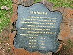
Sak Yai (สักใหญ่) situated at Ban Pang Klua, Tambon Namkrai about 53 km. away from the province with an area of about 20,000 RaiRai (area)
A rai is a unit of area, equal to 1,600 square metres , used for measuring land area. Its current size is precisely derived from the metre, but is neither part of nor recognized by the modern metric system, the International System ....
and is consisted of various unsorted woods. Most important of all this Botanical forest has a biggest teak tree in the world, it has a height of 47 meters and the circumference of the tree stem is measured to be 9.58 m. It is about 1,500 years old by comparison of the size and the number of years from the teak stumps in nearby area. At present there is a height of about 37 meters left because the top of the tree was broken by strong wind, but the stem in general is still left in.
Klong Tron (คลองตรอน) national park has a very natural forest covering areas in Tambon Saentor and Tambon Namkrai of Nam Pat district, Tambon Tham Chalong of Mueang Uttaradit district, Tambon Phaluad of Tha Pla district, Tambon Nam Phi, Tambon Phak Kuang, Tambon Borthong of Thong Saen Khan district in Uttaradit province. Total area is 324,240.80 Rai or about 518.80 km2. It consists of high and low hills.
Pooh Meaing (ภูเมี่ยง) located at Tambon Nam Pai, Phumieng mountains divide Uttaradit province and Phitsanulok province. They are about 1,656 meters above sea level. At the peak, you can view both provinces and can even see Sirikit dam. Moreover, lots of ferns like Kaluang, Dongtao, and Khanmakpa and other plants are found along the way leading to the peak. Klong Tron waterfall of 8 levels is also there but it’s suitable for those who only enjoy adventure and those nature lovers.
Chan cave (ถ้ำจัน) located at Tambon Nam Krai. It is the middle cave of the mountains where 5 of them are located. The way to the cave is very steep and the cave entrance has semicircle shape. Inside we can see a huge room; ceiling is about 20 meter high and in the middle of the cave of front area a Buddha image is located. Stalagmite and stalactite are lovely while weather is very comfortable and cool.
Tao cave (ถ้ำเต่า) located at Tambon Nam Krai. It is on another mountain and about 620 meters away from Tham Chan Cave. Cave entrance has several big stones; you have to notice in order to recognize the cave. From the cave entrance, a walk way has an excavation which looks like a stone sculpture. The way to the cave is a bit complicated; on the left side has a 17meter long hollow being steep until the first room. From here, there is a tiny hole where you can go through. Another room is linked with the right walk way. From here, you can walk to the large room where a 6-meter high stone pillar is in the middle. In the cave, are beautiful stalagmite and stalactite; weather is comfortable and cool.
Phu Soi Dao (ภูสอยดาว) with an area of 125,110 Rai covering Nam Pad district of Uttaradit and Chat Trakan district of Phitsanulok, the park, particularly at the height 1428 metre in Ban Rom Klao, used to be the strong-hold of the communist terrorists. Located in the mountainous area with over 1,800 meters height above sea level, the topography of the park is like that of Phu Kradung. It is cold throughout the year. Beside interesting natural attractions in the park, carrier and tent are available for tourists.
Phu Soi Dao Waterfall, located near the office of the park, is very shady with trees and plants. The 5 level fall houses a tourist service center, No accommodation, but camping site, is available. From the fall to atop the hill takes about 4 – 5 hrs’ walk.
Sai Tip Waterfall (น้ำตกสายทิพย์) located in the middle of the pinery, is one of the most beautiful falls in the park. It has 7 levels, which can be reached by walking from camping area down to the 7th level, each level is not too high, so high so, tourist can admire the beautiful white and clear water falling down along the rocks, covered with moss and lichen which looks like green velvet.
Wat Thamma Thipatai (วัดธรรมาธิปไตย) is where the door panels of the large and ancient Vihan of Wat Phra Fang are kept. The carved design is of the graceful style of the Late Ayutthaya Period. They are rated as the second best such creation next only to those at Wat Suthat in Bangkok.
Wat Tha Thanon (วัดท่าถนน) houses Luang Pho Phet (หลวงพ่อเพชร), the principal Buddha statue of the province. It is of the Chiang Saen style and cast in bronze.
Wat Yai Tha Sao (วัดใหญ่ท่าเสา) It features and old Vihan with beautiful wood-carved door panels and lintels.
The Phraya Phichai Dap Hak Memorial (อนุสาวรีย์พระยาพิชัยดาบหัก) As governor of Muang Phichai (south of Uttaradit) about 200 years ago during the Thon Buri Period, the valiantly fought with Burmese evaders until one of his swords broke in two. But he prevailed over them. Hence the sobriquet “Phichai of the Broken Sword”.
the Uttaradit Provincial Cultural Hall (หอวัฒนธรรมจังหวัดอุตรดิตถ์) houses important historical relics. A major item is the "Yan Mat" (ยานมาศ), a carved wooden carrying pole made by Late Ayutthaya Period craftsmen.
Wat Klang (วัดกลาง) is an old temple with beautiful plaster bas-reliefs over the Ubosot. Inside are rare wall murals of the Early Rattanakosin Period style depicting the Jataka and assemblage of celestial beings.
The Phra Si Phanommat Memorial (อนุสาวรีย์พระศรีพนมมาศ) commemorates a community leader who was highly repeated by the townspeople. The Chinese-descended tax collector on alcohol products contributed tremendously to the development of the community and was rewarded with the rank of Phra Si Phanommat from King Rama V.
Wat Phra Borom That Thung Yang (วัดพระบรมธาตุทุ่งยั้ง) An old temple, it was once called Wat Mahathat. There is a large, circular-shaped, Ceylonese-style Chedi enshrining a Holy Relic.
Wat Phra Yun Phutthabat Yukhon (วัดพระยืนพุทธบาทยุคล) features a Chiang Saen-style Mondop which covers a pair of holy Footprint. It also houses a Sukhothai-style Buddha statue cast in bronze.
Wat Phra Thaen Sila Art (วัดพระแท่นศิลาอาสน์) The major feature is the base of a sermon platform built with laterite. The square slab with pattern is believed to have been made during the Sukhothai Period.
Namtok Mae Phun (น้ำตกแม่พูล), located at Ban Ton Klua, is about 20 kilometres from town. The dam-like barrier creates multi-level cascades amid pleasant natural surroundings.
Bo Lek Nam Phi (บ่อเหล็กน้ำพี้) is the source of the best quality steel which was used to fashion swords and weapons in the past. Today, there are still two "wells" in existence. Ores from these two sources are believed to have been used to make swords for kings only.
Lamnam Nan National Park (อุทยานแห่งชาติลำน้ำน่าน) It is a complex mountain range comprising various kinds of abundant forests. It covers a total area of 624,468 rai and consists of mixed deciduous forest, dry evergreen forest, hill evergreen forest and deciduous dipterocarp forest, where the leaves will transform into beautiful colours during winter and is a habitat of various types of animals such as barking deer, deer, wild boars, bears and more than 200 kinds of birds.
Places of interest in Lamnam Nan National Park are as follows:
- Sirikit Dam (เขื่อนสิริกิติ์) is the country’s large earthen dam.
- Beyond the dam is a large lake with beautiful scenery. During the cool season, the attractively landscape terrain bursts out in a profusion of colourful flowers and blooms.
Local Products
Interesting items include woven materials (ผลิตภัณฑ์จากผ้าพื้นเมือง) with their lovely designs and colours, and preserved edibles made from local fruits such as chewy candy-like Kluai Kuan (กล้วยกวน) which is made from banana.Festivals
Phraya Phichai Dap Hak and Red Cross Fair (งานพระยาพิชัยดาบหักและงานกาชาด) is organized to commemorate the heroic deeds of Phraya Phichai during 7–16 January every year at Phraya Phichai Dap Hak Stadium. There are the Provincial Red Cross Centre’s booths selling products, traditional and cultural performances, various forms of entertainment and a ceremony to worship Phraya Phichai Dap Hak.The Tradition of Buddha Cremation (ประเพณีถวายพระเพลิงพระบรมศพพระพุทธเจ้า), a religious ritual seen nowhere else, is held at Wat Phra Borom That Thung Yang after Visakha Bucha day in May. It features the re-enactment the funeral ceremony for the Lord Buddha.