
Utopia Planitia
Encyclopedia
Utopia Planitia is the largest recognized impact basin on Mars with an estimated diameter of 3300 km, and is the Martian
region where the Viking 2
lander touched down and began exploring on September 3, 1976. It is located at the antipode
of Argyre Planitia
, centered at 49.7°N 118.0°W. It is in the Casius quadrangle
and the Cebrenia quadrangle
of Mars.
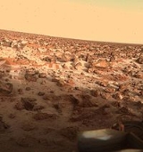
Many rocks at Utopia Planitia appear perched, as if wind removed much of the soil at their bases. A hard surface crust is formed by solutions of minerals moving up through soil and evaporating at the surface.
Mars
Mars is the fourth planet from the Sun in the Solar System. The planet is named after the Roman god of war, Mars. It is often described as the "Red Planet", as the iron oxide prevalent on its surface gives it a reddish appearance...
region where the Viking 2
Viking 2
The Viking 2 mission was part of the American Viking program to Mars, and consisted of an orbiter and a lander essentially identical to that of the Viking 1 mission. The Viking 2 lander operated on the surface for 1,281 Mars days and was turned off on 11 April 1980 when its batteries failed...
lander touched down and began exploring on September 3, 1976. It is located at the antipode
Antipodal point
In mathematics, the antipodal point of a point on the surface of a sphere is the point which is diametrically opposite to it — so situated that a line drawn from the one to the other passes through the centre of the sphere and forms a true diameter....
of Argyre Planitia
Argyre Planitia
Argyre Planitia is a plain located in the Argyre impact basin in the southern highlands of Mars. Its name comes from a map produced by Giovanni Schiaparelli in 1877; it refers to Argyre, a mythical island of silver in Greek mythology....
, centered at 49.7°N 118.0°W. It is in the Casius quadrangle
Casius quadrangle
The Casius quadrangle is one of a series of 30 quadrangle maps of Mars used by the United States Geological Survey Astrogeology Research Program. The quadrangle is located in the north central portion of Mars’ eastern hemisphere and covers 60° to 120° east longitude and 30° to 65° north latitude...
and the Cebrenia quadrangle
Cebrenia quadrangle
The Cebrenia quadrangle is one of a series of 30 quadrangle maps of Mars used by the United States Geological Survey Astrogeology Research Program. The quadrangle is located in the northeastern portion of Mars’ eastern hemisphere and covers 120° to 180° east longitude and 30° to 65° north latitude...
of Mars.
Many rocks at Utopia Planitia appear perched, as if wind removed much of the soil at their bases. A hard surface crust is formed by solutions of minerals moving up through soil and evaporating at the surface.
External links
- Laser altimetry of the north pole of Mars Utopia Planitia located in upper right
- Google Mars scrollable map – centered on Utopia Planitia
- VL2 Site: Utopia Planitia (NASA)
- PIA00576: Martian Sunrise at Utopia Planitia (NASA Photojournal)
- PIA00530: Frost on Utopia Planitia (NASA Photojournal)
- PIA03796: Utopia Planitia (NASA Photojournal)