

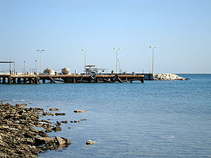
Uqair
Encyclopedia
Saudi Arabia
The Kingdom of Saudi Arabia , commonly known in British English as Saudi Arabia and in Arabic as as-Sa‘ūdiyyah , is the largest state in Western Asia by land area, constituting the bulk of the Arabian Peninsula, and the second-largest in the Arab World...
. It is alternatively spelled Al-'Uqair, Uqayr, and Ogair, all Latin transliterations of the same Arabic word. It has been linked by some to the ancient city of Gerrha
Gerrha
Gerrha , was an ancient city of Arabia, on the west side of the Persian Gulf. More accurately, the ancient city of Gerrha has been determined to have existed near or under the present fort of Uqair. This fort is 50 miles northeast of Al-Hasa in the Eastern Province of Saudi Arabia...
mentioned in Greek and Roman sources. The site was also the location of the 1922 conference at which the Protocol of Uqair
Uqair Protocol of 1922
The Uqair Protocol or Uqair Convention was an agreement at Uqair on 2 December 1922 which defined the boundaries between Iraq and Nejd and between Kuwait and Nejd. It was brokered by Percy Cox, the British High Commissioner to Iraq, in response to Bedouin raiders from Nejd under ibn Saud...
was issued, helping establish the borders of modern Saudi Arabia.
The fort sits about 50 miles northeast of the fertile oasis of Al-Hasa
Al-Hasa
Al-Ahsa is the largest governorate in Saudi Arabia's Eastern Province, named after Al-Ahsa oasis. The name Al-Ahsa is also given to the biggest city in the region, Hofuf. In classic Arabic, Ahsa means the sound of water underground. It has one of the largest oases in the world with Date Palms of...
on the east coast of the Persian Gulf
Persian Gulf
The Persian Gulf, in Southwest Asia, is an extension of the Indian Ocean located between Iran and the Arabian Peninsula.The Persian Gulf was the focus of the 1980–1988 Iran-Iraq War, in which each side attacked the other's oil tankers...
. At this ancient locale are the remains of a large fort that now marks the site of the same name. The current structure that exists is of unknown origin. It is not absolutely clear who built the fort that measures roughly 150 ft. (50 m.) on each side which consists of a stone rampart topped with mud brick. (The Persian Gulf
Persian Gulf
The Persian Gulf, in Southwest Asia, is an extension of the Indian Ocean located between Iran and the Arabian Peninsula.The Persian Gulf was the focus of the 1980–1988 Iran-Iraq War, in which each side attacked the other's oil tankers...
in Antiquity, Vol. II, D.T. Potts, P. 56).
Location
Modern Uqair is 55 miles due south of DhahranDhahran
Dhahran is a city located in Saudi Arabia's Eastern Province, and is a major administrative center for the Saudi oil industry. Large oil reserves were first identified in the Dhahran area in 1931, and in 1935 Standard Oil of California drilled the first commercially viable oil well...
, a Saudi Aramco
Saudi Aramco
Saudi Aramco , officially the Saudi Arabian Oil Company, is the national oil company of Saudi Arabia.Saudi Aramco is the world's largest and most valuable privately-held company, with estimates of its value in 2011 to be $7 trillion USD.Saudi Aramco has both the largest proven crude oil reserves,...
compound. It lies about 50 miles northeast of the fertile oasis of Al-Ahsa
Al-Hasa
Al-Ahsa is the largest governorate in Saudi Arabia's Eastern Province, named after Al-Ahsa oasis. The name Al-Ahsa is also given to the biggest city in the region, Hofuf. In classic Arabic, Ahsa means the sound of water underground. It has one of the largest oases in the world with Date Palms of...
and its main city Hofuf
Hofuf
Al-Hofuf is the major urban center in the Al-Ahsa Oasis in the Eastern Province of Saudi Arabia.- Overview :...
on the eastern shore of the Persian Gulf
Persian Gulf
The Persian Gulf, in Southwest Asia, is an extension of the Indian Ocean located between Iran and the Arabian Peninsula.The Persian Gulf was the focus of the 1980–1988 Iran-Iraq War, in which each side attacked the other's oil tankers...
, on a straight line between the oasis and the island state of Bahrain
Bahrain
' , officially the Kingdom of Bahrain , is a small island state near the western shores of the Persian Gulf. It is ruled by the Al Khalifa royal family. The population in 2010 stood at 1,214,705, including 235,108 non-nationals. Formerly an emirate, Bahrain was declared a kingdom in 2002.Bahrain is...
.The new Uqair- Al-Hasa road (35 miles) which was constructed recently and passes by Al-Jishah town will support the economic development of Al-Hasa oasis.
Modern maps place Uqair at the harbor and shallow lagoon the fort was built next to.
Other important surrounding locations of antiquity
The location of pre-Islamic Al-Hasa is of great importance and relevance to Uqair. Artesian wells once fed "a series of interconnected streams and lakes draining north eastward toward the Persian GulfPersian Gulf
The Persian Gulf, in Southwest Asia, is an extension of the Indian Ocean located between Iran and the Arabian Peninsula.The Persian Gulf was the focus of the 1980–1988 Iran-Iraq War, in which each side attacked the other's oil tankers...
above Uqair. Reports of the existence of this active ravine system can be traced back to the time of Pliny." (Potts, p. 29). Evidence of this effluent has a great bearing on the exploration of the fort at Uqair and the ancient Arabian city of Gerrha
Gerrha
Gerrha , was an ancient city of Arabia, on the west side of the Persian Gulf. More accurately, the ancient city of Gerrha has been determined to have existed near or under the present fort of Uqair. This fort is 50 miles northeast of Al-Hasa in the Eastern Province of Saudi Arabia...
. A large source of fresh water near the Persian Gulf
Persian Gulf
The Persian Gulf, in Southwest Asia, is an extension of the Indian Ocean located between Iran and the Arabian Peninsula.The Persian Gulf was the focus of the 1980–1988 Iran-Iraq War, in which each side attacked the other's oil tankers...
is reason enough to create a trading port located at Uqair and to facilitate the civilization that flourished at Al-Hasa. It is well documented that the Al-Hasa region and most notably Uqair were once considered to be strong candidates for the possible lost city of Gerrha, an emporium of trade and mercantile activity dating to at least 225 BC.
Other ancient civilizations flourished in the surrounding area. Across the shallow Gulf strait sixty miles to the northeast are the ancient burial mounds of what is now known to be the lost ancient civilization of Dilmun
Dilmun
Dilmun or Telmun is a land mentioned by Mesopotamian civilizations as a trade partner, a source of the metal copper, and an entrepôt of the Mesopotamia-to-Indus Valley Civilization trade route...
. These burial mounds estimated at more than 100,000, rest on the island of Bahrain
Bahrain
' , officially the Kingdom of Bahrain , is a small island state near the western shores of the Persian Gulf. It is ruled by the Al Khalifa royal family. The population in 2010 stood at 1,214,705, including 235,108 non-nationals. Formerly an emirate, Bahrain was declared a kingdom in 2002.Bahrain is...
(Looking for Dilmun, Geoffrey Bibby, p. 7). On the Arabian Peninsula, the walled city of Thaj is 80 miles north of Uqair and just 20 miles inland from another ancient Arabian oasis, Qatif
Qatif
Qatif or Al-Qatif is a governorate and urban area located in Eastern Province, Saudi Arabia. It extends from Ras Tanura and Jubail in the north to Dammam in the south, and from the Persian Gulf in the east to King Fahd International Airport in the west...
. Both of these sites have been dated to at least the Hellenistic period
Hellenistic period
The Hellenistic period or Hellenistic era describes the time which followed the conquests of Alexander the Great. It was so named by the historian J. G. Droysen. During this time, Greek cultural influence and power was at its zenith in Europe and Asia...
. The Saudi island of Tarut, another rich archeological area, lies 40 miles to the east of the old port and fishing village of Jubail
Jubail
Jubail , is a city in the Eastern province on the Persian Gulf coast of Saudi Arabia. It consists of the Old Town of Al Jubail, which was originally a small fishing village, up to 1975 and the new industrial area....
, which once served Thaj and Qatif, and is located about 35 miles north of Uqair.
Links to ancient Gerrha
Ancient GerrhaGerrha
Gerrha , was an ancient city of Arabia, on the west side of the Persian Gulf. More accurately, the ancient city of Gerrha has been determined to have existed near or under the present fort of Uqair. This fort is 50 miles northeast of Al-Hasa in the Eastern Province of Saudi Arabia...
has been associated with several locations. The notorious shifting sands of the desert have made it difficult to locate the trading emporium, well described in general history and archeological texts. Even though Uqair is the present location of what is believed to be an Islamic fort, the whole region twenty miles north of the current structure was also referred to as Uqair, or Gerrha, long before the fort was built. The lost city of Gerrha according to Danish archeologist Geoffrey Bibby
Geoffrey Bibby
Thomas Geoffrey Bibby was an English-born archaeologist. He is best known for discovering the ancient state of Dilmun, referred to in Mesopotamian mythology as a paradise....
, however, "still awaits its discoverer." (Bibby, p. 325)
Ties to Mesopotamia
Trade and commerce of early civilizations in the Persian Gulf region was both the umbilical cord to surrounding cultures and the eventual physical link that has allowed scientists and researchers to literally piece together its murky history. The greatest regional center of civilization lay only 300 miles north of Uqair at the confluence of the TigrisTigris
The Tigris River is the eastern member of the two great rivers that define Mesopotamia, the other being the Euphrates. The river flows south from the mountains of southeastern Turkey through Iraq.-Geography:...
and Euphrates
Euphrates
The Euphrates is the longest and one of the most historically important rivers of Western Asia. Together with the Tigris, it is one of the two defining rivers of Mesopotamia...
Rivers. Mesopotamia
Mesopotamia
Mesopotamia is a toponym for the area of the Tigris–Euphrates river system, largely corresponding to modern-day Iraq, northeastern Syria, southeastern Turkey and southwestern Iran.Widely considered to be the cradle of civilization, Bronze Age Mesopotamia included Sumer and the...
, a very fertile region north of this confluence in modern Iraq
Iraq
Iraq ; officially the Republic of Iraq is a country in Western Asia spanning most of the northwestern end of the Zagros mountain range, the eastern part of the Syrian Desert and the northern part of the Arabian Desert....
, and where Sumer
Sumer
Sumer was a civilization and historical region in southern Mesopotamia, modern Iraq during the Chalcolithic and Early Bronze Age....
ian civilization began. By 3500 BC the Sumerians were living and trading beyond the Strait of Hormuz
Strait of Hormuz
The Strait of Hormuz is a narrow, strategically important waterway between the Gulf of Oman in the southeast and the Persian Gulf. On the north coast is Iran and on the south coast is the United Arab Emirates and Musandam, an exclave of Oman....
, venturing out as far as the Indus River
Indus River
The Indus River is a major river which flows through Pakistan. It also has courses through China and India.Originating in the Tibetan plateau of western China in the vicinity of Lake Mansarovar in Tibet Autonomous Region, the river runs a course through the Ladakh district of Jammu and Kashmir and...
and the Red Sea
Red Sea
The Red Sea is a seawater inlet of the Indian Ocean, lying between Africa and Asia. The connection to the ocean is in the south through the Bab el Mandeb strait and the Gulf of Aden. In the north, there is the Sinai Peninsula, the Gulf of Aqaba, and the Gulf of Suez...
. The Sumerians were conquered by the Semitic Akkadians in 2340, becoming united under Babylon from 1792 - 1750 BC.
Within the same general timeline of these dominating civilizations there existed several other cultures and dynasties; the Barbar, Seleucid, and Chaldaean
Chaldea
Chaldea or Chaldaea , from Greek , Chaldaia; Akkadian ; Hebrew כשדים, Kaśdim; Aramaic: ܟܐܠܕܘ, Kaldo) was a marshy land located in modern-day southern Iraq which came to briefly rule Babylon...
- exiles from Babylonia who were among the central players of Gerrha and Uqair.
Dilmun
Gerrha was preceded by the legendary Sumerian-era civilization of DilmunDilmun
Dilmun or Telmun is a land mentioned by Mesopotamian civilizations as a trade partner, a source of the metal copper, and an entrepôt of the Mesopotamia-to-Indus Valley Civilization trade route...
(4000 - 2000 BC), which has been archeologically linked to the northern tip of Bahrain
Bahrain
' , officially the Kingdom of Bahrain , is a small island state near the western shores of the Persian Gulf. It is ruled by the Al Khalifa royal family. The population in 2010 stood at 1,214,705, including 235,108 non-nationals. Formerly an emirate, Bahrain was declared a kingdom in 2002.Bahrain is...
. During its zenith, the culture controlled the oceanic trading routes to the Indies and was the trading link to the Indus Valley and Mesopotamia
Mesopotamia
Mesopotamia is a toponym for the area of the Tigris–Euphrates river system, largely corresponding to modern-day Iraq, northeastern Syria, southeastern Turkey and southwestern Iran.Widely considered to be the cradle of civilization, Bronze Age Mesopotamia included Sumer and the...
(Area Handbook for the Persian Gulf States, 1st Edition, p. 11). To the Sumerians, Dilmun was the land of immortality and the god of Abzu. The second sea of fresh water that lay beneath the gulf and was believed to flow from the Tigris
Tigris
The Tigris River is the eastern member of the two great rivers that define Mesopotamia, the other being the Euphrates. The river flows south from the mountains of southeastern Turkey through Iraq.-Geography:...
and Euphrates
Euphrates
The Euphrates is the longest and one of the most historically important rivers of Western Asia. Together with the Tigris, it is one of the two defining rivers of Mesopotamia...
under the ground to present Bahrain - in the land called Enki. "Dilmun founded a maritime network unrivaled for its breadth by any other in the early days of man's world ... it was home of the Utunapishtim, who survived the flood, it was soapstone for figurines, alabaster for bowls, carnelian heads beads, cowries and pearls ... it was copper and lapis lazuli." ("The Sumerian Connection", Jon Mandaville and Michael Grimsdale, ARAMCO World March/April 1980). Dilmun is the "Paradise Land, the original home of the gods, the archetypical Holy Land" to which the Mesopotamian hero Gilgamesh
Gilgamesh
Gilgamesh was the fifth king of Uruk, modern day Iraq , placing his reign ca. 2500 BC. According to the Sumerian king list he reigned for 126 years. In the Tummal Inscription, Gilgamesh, and his son Urlugal, rebuilt the sanctuary of the goddess Ninlil, in Tummal, a sacred quarter in her city of...
travels to in his epic journey. (Dilmun Discovered, Michael Rice, p. 7).
Historical mentions of Gerrha
In accounts written by his biographer Arrian, Alexander the Great mentions a planned coastal exploration of 323 BC that includes the eastern Arabian coast but does not mention Gerrha. A hundred years later, however, EratosthenesEratosthenes
Eratosthenes of Cyrene was a Greek mathematician, poet, athlete, geographer, astronomer, and music theorist.He was the first person to use the word "geography" and invented the discipline of geography as we understand it...
tells of merchants from Gerrha carrying their spices and incense overland to Mesopotamia. And later Strabo
Strabo
Strabo, also written Strabon was a Greek historian, geographer and philosopher.-Life:Strabo was born to an affluent family from Amaseia in Pontus , a city which he said was situated the approximate equivalent of 75 km from the Black Sea...
quotes Artimedoros: "by the incense trade ... the Gerrhaei have become the richest of all the tribes and possess great quantity of wrought articles in gold and silver." (Bibby, p. 317). Gerrha is described by Pliny the Elder
Pliny the Elder
Gaius Plinius Secundus , better known as Pliny the Elder, was a Roman author, naturalist, and natural philosopher, as well as naval and army commander of the early Roman Empire, and personal friend of the emperor Vespasian...
: "On the Arabian shore of the Gulf one comes to the island Ichara and then the Gulf of Capeus where we find the city of Gerrha, five miles in circumference, with towers built of square blocks of salt. Fifty miles from the east lying in the interior is the region of Attene and opposite to Gerrha is the island of Tylos." (Bibby, p. 318).
Wealth of Gerrha
In 200 BC a Greek grammarian named Agathrachides, who wrote a book on the Erythraean (modern Red) Sea now lost, is quoted by the Roman geographer/historian StraboStrabo
Strabo, also written Strabon was a Greek historian, geographer and philosopher.-Life:Strabo was born to an affluent family from Amaseia in Pontus , a city which he said was situated the approximate equivalent of 75 km from the Black Sea...
on Gerrha: "from their trafficking, the Gerrhaeans have become the richest of all; and they have a vast equipment of both gold and silver articles, such as couches and tripods and bowls, together with drinking vessels and very costly houses; for doors and wall and ceilings are variegated with ivory and gold and silver set with precious stones." (Frankincense and Myrrh, A Study of Arabian Incense Trade, Nigel Groom, p. 67). The city of Gerrha played a central role in the interchange of commodities of certain regions of the Arabian Peninsula
Arabian Peninsula
The Arabian Peninsula is a land mass situated north-east of Africa. Also known as Arabia or the Arabian subcontinent, it is the world's largest peninsula and covers 3,237,500 km2...
during the reign of the Seleucid King Antioch III, (223 - 187 BC). Most notable was the frankincense
Frankincense
Frankincense, also called olibanum , is an aromatic resin obtained from trees of the genus Boswellia, particularly Boswellia sacra, B. carteri, B. thurifera, B. frereana, and B. bhaw-dajiana...
and myrrh
Myrrh
Myrrh is the aromatic oleoresin of a number of small, thorny tree species of the genus Commiphora, which grow in dry, stony soil. An oleoresin is a natural blend of an essential oil and a resin. Myrrh resin is a natural gum....
of southwestern Arabia in Yemen
Yemen
The Republic of Yemen , commonly known as Yemen , is a country located in the Middle East, occupying the southwestern to southern end of the Arabian Peninsula. It is bordered by Saudi Arabia to the north, the Red Sea to the west, and Oman to the east....
's Hadramawt region.
The Gerrhaeans also traded with East Africa and China through India. In their activity "they act as the warehouse for everything from Asia and Europe ... seem more prosperous than the Sabaeans
Sabaeans
The Sabaeans or Sabeans were an ancient people speaking an Old South Arabian language who lived in what is today Yemen, in the south west of the Arabian Peninsula.Some scholars suggest a link between the Sabaeans and the Biblical land of Sheba....
." (Groom, p. 71). Trade through Gerrha was heavy in the time of Antioch; Strabo
Strabo
Strabo, also written Strabon was a Greek historian, geographer and philosopher.-Life:Strabo was born to an affluent family from Amaseia in Pontus , a city which he said was situated the approximate equivalent of 75 km from the Black Sea...
writes: "the leading people of this time were the Gerrhaeans, and the Arab tribe whose capital lay on the mainland just opposite Bahrain made ... enormous incomes by trading the precious wares of Arabia and India to the mouths of the Euphrates and Tigris, along the upper course of the rivers by ancient caravan routes to the coast of Syria and Phoenicia
Phoenicia
Phoenicia , was an ancient civilization in Canaan which covered most of the western, coastal part of the Fertile Crescent. Several major Phoenician cities were built on the coastline of the Mediterranean. It was an enterprising maritime trading culture that spread across the Mediterranean from 1550...
even as far as Delos and the Aegean Sea
Aegean Sea
The Aegean Sea[p] is an elongated embayment of the Mediterranean Sea located between the southern Balkan and Anatolian peninsulas, i.e., between the mainlands of Greece and Turkey. In the north, it is connected to the Marmara Sea and Black Sea by the Dardanelles and Bosporus...
." (Bibby, p. 113).
The lure of wealth generated in Gerrha by its inhabitants was too tempting for Antiochus to avoid. In 205 BC, he felt it necessary to make a large-scale military incursion against the Gerrhaeans with the object of securing himself a reasonable portion of their trade. (Bibby, p. 330). Antiochus was diverted from his goal of capturing the city, however, when the "Gerrhaeans bought off his attack with 500 talents of silver, 1000 talents of frankincense, and 200 talents of 'stacte' myrrh." (Groom, p. 195).
Geoffrey Bibby and Uqair
Geoffrey BibbyGeoffrey Bibby
Thomas Geoffrey Bibby was an English-born archaeologist. He is best known for discovering the ancient state of Dilmun, referred to in Mesopotamian mythology as a paradise....
, a Danish archeologist who excavated on the island of Bahrain from 1954 to 1969 and claimed it to be Dilmun, included Uqair, across the straits, in his investigations, visiting it on three separate journeys, in 1963 by air only, and in1965 and in 1968 by land. Bibby wrote:
"Tylos we knew was Bahrain...Attene, was fifty miles inland, was normally believed to be the Hofuf
Hofuf
Al-Hofuf is the major urban center in the Al-Ahsa Oasis in the Eastern Province of Saudi Arabia.- Overview :...
oasis. On the coast, in the direct line between Hofuf and Bahrain, lay the village of Uqair, and beside it the ruins of a large walled town. It had seemed obvious to many modern theorists that Uqair must be Gerrha and the identification seemed clinched by the fact that in the local dialect of the Arabic, the letter 'q' was pronounced as a 'g.' Uqair is pronounced Ogair, which is close enough to the Greek name to be convincing." (Bibby, p. 318).
In Bibby's quest for the city of Dilmun he managed three sondages (digs) at the city of Uqair. Of his investigation, he detailed his search for pre-Islamic clues: "the ruined city of Uqair stretches more vastly on the ground than it appeared from the air. I followed ... the northern wall across the subkha [Arabic term for dried salt flats] toward the shore, the ruined tower - certainly a modern addition - marked the southwestern corner ... ahead of me the wall ended at a coastal tower, but like the wall, only a course or so high ... and beyond the strait lay the mud brick houses and yellow fort of the present villages." (Bibby, p. 323).
Bibby details the construction of the wall and deduces that "the wall was built of a coral like conglomerate called farush," which to Bibby "felt wrong because of the fluctuating level of sea water." He stated; "If anywhere there was a subkha today there should have been water even as recently as 2000 years ago. If that were true then this wall (at Uqair) could not be as old as the wall at Thaj." (Bibby, p. 324). (The walls of Thaj, another ruined city near Qatif, were built during the same period as Gerrha - the Greek period.) But as Bibby concludes ... "in the cities of the Greek period on Bahrain and the temple of towns of the Seleucid on Failaka (an island off the coast of Kuwait
Kuwait
The State of Kuwait is a sovereign Arab state situated in the north-east of the Arabian Peninsula in Western Asia. It is bordered by Saudi Arabia to the south at Khafji, and Iraq to the north at Basra. It lies on the north-western shore of the Persian Gulf. The name Kuwait is derived from the...
once thought to be a Hellenistic foundry of coins) farush was never used. The walls there were made of quarried limestone." (Bibby, p. 324.)
Northwest of Uqair, referred to as the salt mine site, or Gerrha, are the extensive remains of irrigation works and fields visible on aerial photographs of the area, some of which may be dated to the Hellenistic period
Hellenistic period
The Hellenistic period or Hellenistic era describes the time which followed the conquests of Alexander the Great. It was so named by the historian J. G. Droysen. During this time, Greek cultural influence and power was at its zenith in Europe and Asia...
. (Potts, p. 56-57). Bibby went to these irrigation channels to dig and search for artifacts in 1968. He excavated what he labeled the "subkha fort and produced several shards comparable to types known from Thaj and Hellenistic Bahrain. Identical results were obtained in a sounding carried out in a different structure. This was the so called inland fort. It measured 150 ft. (49 m) by 156 ft. (52 m) and was constructed by large stone ashlars. The contention has sometimes been made that this was the site of ancient Gerrha, but there is no evidence to support this. (Potts, p. 56-57). The site of the fort is not the same as the irrigation channels.
Portuguese influence
It is not impossible the fort at Uqair could be the result of the PortuguesePortugal
Portugal , officially the Portuguese Republic is a country situated in southwestern Europe on the Iberian Peninsula. Portugal is the westernmost country of Europe, and is bordered by the Atlantic Ocean to the West and South and by Spain to the North and East. The Atlantic archipelagos of the...
domination of the Persian Gulf, which began in 1506 with the expedition of Afonso de Albuquerque
Afonso de Albuquerque
Afonso de Albuquerque[p][n] was a Portuguese fidalgo, or nobleman, an admiral whose military and administrative activities as second governor of Portuguese India conquered and established the Portuguese colonial empire in the Indian Ocean...
. His mission was to destroy Arab trade and establish Portuguese dominance. Their oppressive influence may have completely transformed the regional power structure but they left no religious and hardly any cultural imprint, except for their cannons and ruined garrisons. (From the Trucial States to the United Arab Emirates, Frauke Heard-Bay, p. 271). Before the Portuguese, "wealthy city states were developed around favorably situated harbors ... inhabited mostly by Arab tribes ... to dominate the entrepot trade between India, Arab countries and Europe, which passed through Mesopotamia and the Red Sea." (From the Trucial States to the United Arab Emirates, Geoffrey Frauke Heard-Bey, p. 271). The construction of Portuguese forts was common. A large structure still stands on the island of Bahrain (1521 AD) in recognition of its importance as a favorable position to assert their power and control of the Persian Gulf by way of the Straits of Hormuz. (Dilmun Discovered, Michael Rice, p. 70). The Portuguese left the Gulf in 1648 after several revolts of Arab natives attempted to regain their harbors and trade. The confusion and growing interest of the Turks (who also built forts in the region) and Persians created a situation for the Portuguese which they could not control. (The Arabian Peninsula, George Allen, p. 94).
Conference of Uqair
Lastly, Uqair was an historic meeting place of major early Arabian political importance. In 1922, prominent politicians and leaders met to discuss and from new boundaries of the growing Arab state under Ibn Saud, the new revolutionary leader who was conquering the peninsula and attempting to unite it. In attendance at the Conference of Uqair was Sir Percy Zachariah CoxPercy Zachariah Cox
Major-General Sir Percy Zachariah Cox, GCMG, GCIE, KCSI was a British Indian Army officer and colonial administrator in the Middle East. In the late 19th century and early 20th century, he was one of the major figures in the creation of Iraq...
of Great Britain. Representing the not yet established kingdom of Saudi Arabia was Ibn Saud himself. The purpose of the rendezvous was to harness and "guarantee the limits of Saudi expansion." (House of Saud, David Holden/Richard Johns, p. 79). At the meeting, the delegates formed the Protocol of Uqair
Uqair Protocol of 1922
The Uqair Protocol or Uqair Convention was an agreement at Uqair on 2 December 1922 which defined the boundaries between Iraq and Nejd and between Kuwait and Nejd. It was brokered by Percy Cox, the British High Commissioner to Iraq, in response to Bedouin raiders from Nejd under ibn Saud...
to define the borders between northeastern Saudi Arabia
Saudi Arabia
The Kingdom of Saudi Arabia , commonly known in British English as Saudi Arabia and in Arabic as as-Sa‘ūdiyyah , is the largest state in Western Asia by land area, constituting the bulk of the Arabian Peninsula, and the second-largest in the Arab World...
with Kuwait
Kuwait
The State of Kuwait is a sovereign Arab state situated in the north-east of the Arabian Peninsula in Western Asia. It is bordered by Saudi Arabia to the south at Khafji, and Iraq to the north at Basra. It lies on the north-western shore of the Persian Gulf. The name Kuwait is derived from the...
and Iraq
Iraq
Iraq ; officially the Republic of Iraq is a country in Western Asia spanning most of the northwestern end of the Zagros mountain range, the eastern part of the Syrian Desert and the northern part of the Arabian Desert....
. Sir Percy Cox reportedly drew a line on the map from the head of the Gulf (in the east) to the Trans-Jordan frontier (in the west). It gave Ibn Saud a large chunk of territory by Kuwait ... but transferred another large slice of Ibn Saud's territory into Iraqi hands. And to meet the needs of the Bedouin tribes ... a neutral zone." (The House of Saud, David Holden and Richard Johns, p. 80). Back then, Kuwait was under the ruling of Sheik Ahmad Al Jaber, who did not attend the meeting and was later informed of the new borders.
Conclusion
The history of Uqair is multi-faceted. The irrigation channels north of Uqair could be the abandoned city of Gerrha. And it is alternatively possible the lost city lay beneath the subkha near the ruined Islamic city of Uqair. But Bibby's efforts to dig the channels and beneath the walls of Uqair proved fruitless in the search for Gerrha. (Looking for Dilmun, Geoffrey Bibby, p. 372). It is the belief of the author of this article that the fort at Uqair is of Islamic origin and constructed by Arabs in defense and in anticipation of foreign attack, that eventually arrived in form of the Portuguese. Despite the lack of conclusively identifying its original builders, Uqair stands in quiet aura as a testimony to a mysterious and diverse cultural landscape that flourished in its proximity.Further reading
- Area Handbook for the Persian Gulf States, 1st Edition.
- Bibby, G., Looking for Dilmun.
- Frauke Heard-Bey , G. A. 1996. From the Trucial States to the United Arab Emirates.
- Groom, N., Frankincense and Myrrh, A Study of Arabian Incense Trade.
- Holden, D., and Johns, R. The House of Saud.
- Mandaville, J. and Grimsdale M., "The Sumerian Connection", ARAMCO World, March/April 1980.
- Potts, D. T., The Persian Gulf in Antiquity, Vol. II.
- Rice, M., Dilmun Discovered.
- A Visit To Some Early Cities, 1963, Saudi Aramco World