

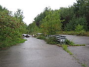
Unused highway
Encyclopedia


Highway
A highway is any public road. In American English, the term is common and almost always designates major roads. In British English, the term designates any road open to the public. Any interconnected set of highways can be variously referred to as a "highway system", a "highway network", or a...
or highway ramp that was partially or fully constructed, but was unused or later closed. An unused ramp can be referred to as a stub ramp, stub street, stub-out, or simply stub.
Examples
Some examples of reasons for unused highways include:- An older portion of roadway being left unused by a highway realignment. The abandoned Pennsylvania TurnpikeAbandoned Pennsylvania TurnpikeThe Abandoned Pennsylvania Turnpike is the common name of a 13 mile stretch of the Pennsylvania Turnpike that was bypassed in 1968 when a modern stretch opened to ease traffic congestion in the tunnels. In this case, the Sideling Hill Tunnel and Rays Hill Tunnel were bypassed, as was one of the...
is one instance of this, where two two-lane tunnels and four-lane approaches were bypassed with four-lane cuts. The old tunnels and approach roadways in this case are being rehabilitated for a multi-use trail. - A highway being closed and demolished, where stubs remain on intersecting roads. Examples include ramps from the Embarcadero Freeway that remained on the Bay Bridge approach (Interstate 80) in San Francisco after the demolition of the Embarcadero Freeway proper. The remaining ramps were demolished in 2010-11 during demolition of the old Transbay TerminalSan Francisco Transbay TerminalSan Francisco Transbay Transit Terminal, or simply Transbay Terminal, was a transportation complex in San Francisco, California, USA, located roughly in the center of the rectangle bounded north–south by Mission Street and Howard Street, and east–west by Beale Street and 2nd Street...
to make way for the new Transbay Transit CenterSan Francisco Transbay developmentThe San Francisco Transbay development plan consists of three supertall skyscrapers and ten other skyscrapers and highrises proposed in San Francisco. The towers are proposed to fund the replacement of the San Francisco Transbay Terminal in the South of Market neighborhood near the Financial...
. - Highway construction begins but is canceled, possibly because of a freeway revoltFreeway and expressway revoltsMany freeway revolts took place in developed countries during the 1960s and 1970s, in response to plans for the construction of new freeways, a significant number of which were abandoned or significantly scaled back due to widespread public opposition; especially of those whose neighborhoods would...
. Examples include the Pennsylvania Route 23 "Goat Path" east of Lancaster, which was graded for a four-lane expressway. The project was canceled before paving could commence, so the roadbeds were planted over with grass. In LondonLondonLondon is the capital city of :England and the :United Kingdom, the largest metropolitan area in the United Kingdom, and the largest urban zone in the European Union by most measures. Located on the River Thames, London has been a major settlement for two millennia, its history going back to its...
, the M11 motorwayM11 motorwayThe M11 motorway in England is a major road running approximately north from the North Circular Road in South Woodford in north-east London to the A14, north-west of Cambridge.-Route:...
has two short unused slips at Junction 4 (Charlie Brown's) which would have been a link for the M12 motorwayM12 motorwayThe M12 motorway was a planned motorway starting in north-east London and joining the A12 road in Essex. The 1960s scheme would have started at a junction with the M11 motorway and North Circular and ended near Brentwood, Chelmsford or at the proposed new Maplin Sands airport; the motorway was part...
to head east into EssexEssexEssex is a ceremonial and non-metropolitan county in the East region of England, and one of the home counties. It is located to the northeast of Greater London. It borders with Cambridgeshire and Suffolk to the north, Hertfordshire to the west, Kent to the South and London to the south west...
. - Stubs are built to connect to a highway that is not yet constructed. These stubs ramps are very common in the state of North CarolinaNorth CarolinaNorth Carolina is a state located in the southeastern United States. The state borders South Carolina and Georgia to the south, Tennessee to the west and Virginia to the north. North Carolina contains 100 counties. Its capital is Raleigh, and its largest city is Charlotte...
, where they will eventually connect to new stretches of I-73Interstate 73Interstate 73 is a main route of the Interstate Highway System, currently located entirely within the U.S. state of North Carolina. It is part of a longer planned corridor, defined by various Federal laws to run from Myrtle Beach, South Carolina, to Grayling, Michigan, but only the part south of...
, I-74Interstate 74 in North CarolinaIn the U.S. state of North Carolina, Interstate 74 is an Interstate Highway that is partially completed. Currently in four distinct segments in the state; when completed, it will traverse in a southeasterly direction from Virginia to South Carolina, connecting the cities of Winston-Salem, High...
, I-485 and I-840, among others, along the Greensboro Urban LoopGreensboro Urban LoopThe Greensboro Urban Loop is a planned 41-mile beltway around Greensboro, North Carolina, United States. The loop carries Interstate 85 and U.S. Route 421 on its southern section, and Interstate 73 from U.S. 220 to Bryan Boulevard along the west side of Greensboro...
. - The highway is used for a different purpose than originally intended. The east end of Interstate 70 in Baltimore and the stub of Interstate 95 inside the Capital BeltwayInterstate 495 (Capital Beltway)Interstate 495 is a Interstate Highway that surrounds the United States' capital of Washington, D.C., and its inner suburbs in adjacent Maryland and Virginia. I-495 is widely known as the Capital Beltway or simply the Beltway, especially when the context of Washington, D.C., is clear...
northeast of Washington are two examples due to cancellations of their alignments within the inner city. Both of these stubs are used for park-and-ride facilities. In England, improvement works in 1987 rerouted the A47A47 roadThe A47 is a trunk road in England originally linking Birmingham to Great Yarmouth. Most of the section between Birmingham and Nuneaton is now classified as the B4114.-Route:...
in RutlandRutlandRutland is a landlocked county in central England, bounded on the west and north by Leicestershire, northeast by Lincolnshire and southeast by Peterborough and Northamptonshire....
near WardleyWardley, RutlandWardley is a village and civil parish in the county of Rutland in the East Midlands of England. It is located about two miles west of Uppingham, close to the A47. The two-mile £1.9 million Wardley Hill Improvement opened in October 1987 when the road through the village became a dead end...
resulting in an unused stretch of carriageway being left behind which functions only as access to a transmitting station. Part of the A2A2 road (Great Britain)The A2 is a major road in southern England, connecting London with the English Channel port of Dover in Kent. This route has always been of importance as a connection between the British capital of London and sea trade routes to Continental Europe...
in KentKentKent is a county in southeast England, and is one of the home counties. It borders East Sussex, Surrey and Greater London and has a defined boundary with Essex in the middle of the Thames Estuary. The ceremonial county boundaries of Kent include the shire county of Kent and the unitary borough of...
was realigned in 2009, leaving a substantial part of the original road intact. Part of the road has been made into a public park. On Interstate 90Interstate 90Interstate 90 is the longest Interstate Highway in the United States at . It is the northernmost coast-to-coast interstate, and parallels US 20 for the most part. Its western terminus is in Seattle, at Edgar Martinez Drive S. near Safeco Field and CenturyLink Field, and its eastern terminus is in...
near Albany, New YorkAlbany, New YorkAlbany is the capital city of the U.S. state of New York, the seat of Albany County, and the central city of New York's Capital District. Roughly north of New York City, Albany sits on the west bank of the Hudson River, about south of its confluence with the Mohawk River...
, an interchange was built for the never-to-be Interstate 687Interstate 687Interstate 687 was a proposed auxiliary Interstate Highway in the Capital District region of New York in the United States. The highway would have connected I-90 in Albany to I-87 near Albany International Airport in Colonie...
; that interchange (labeled as Exit 5A off I-90) now serves as an exit for Corporate Woods Boulevard. The exit ramps occupy nearly as much space as the area they serve. - The highway has unused lanes. The 1000 Islands Parkway contains two "ghost lanes" for its entire 40 km length. Its right-of-way is four-lane-divided, as it was originally intended to serve Highway 401Highway 401 (Ontario)King's Highway 401, also known by its official name as the Macdonald–Cartier Freeway and colloquially as the four-oh-one, is a 400-Series Highway in the Canadian province of Ontario stretching from Windsor to the Quebec border...
, a portion of Canada's busiest highway. When the 401 was ultimately constructed further inland, two lanes of the original right-of-way were used for the parkway, the rest becoming small pedestrian or bicycle trails laid out in an otherwise-vacant freeway-grade right-of-way.
Railway and other stubs
Stubs may also be found in rail networks. Near Lambert Airport in St. Louis, MissouriSt. Louis, Missouri
St. Louis is an independent city on the eastern border of Missouri, United States. With a population of 319,294, it was the 58th-largest U.S. city at the 2010 U.S. Census. The Greater St...
, a stub exists for the city's light rail
Light rail
Light rail or light rail transit is a form of urban rail public transportation that generally has a lower capacity and lower speed than heavy rail and metro systems, but higher capacity and higher speed than traditional street-running tram systems...
system, Metrolink
St. Louis Metrolink
MetroLink is the light rail transit system in the Greater St. Louis area of Missouri and the Metro East area of Illinois. The entire system currently consists of two lines connecting Lambert-St. Louis International Airport and Shrewsbury, MO with Scott Air Force Base near Shiloh, Illinois through...
, for a future northern extension. In California, an abandoned stretch of railway connecting the Colma (BART station)
Colma (BART station)
Colma Station is a Bay Area Rapid Transit station located in unincorporated Colma, California, in northern San Mateo County, adjacent to incorporated Colma and Daly City. Situated in a small valley immediately adjacent to a BART rail yard, the station consists of three main tracks with a shared...
with the South San Francisco Caltrain Station is overgrown with weeds and sections are paved over with asphalt. It runs along Railway Avenue for most of the stretch, then enters suburban neighborhoods via South San Francisco. From Colma, it crosses over the El Camino Real
El Camino Real (California)
El Camino Real and sometimes associated with Calle Real usually refers to the 600-mile California Mission Trail, connecting the former Alta California's 21 missions , 4 presidios, and several pueblos, stretching from Mission San Diego de Alcalá in San Diego...
before entering a tunnel.
At the Kennedy Space Center
Kennedy Space Center
The John F. Kennedy Space Center is the NASA installation that has been the launch site for every United States human space flight since 1968. Although such flights are currently on hiatus, KSC continues to manage and operate unmanned rocket launch facilities for America's civilian space program...
, there is a stub off the crawlerway for launch pad 39B
Kennedy Space Center Launch Complex 39
Launch Complex 39 is a rocket launch site at the John F. Kennedy Space Center on Merritt Island in Florida, USA. The site and its collection of facilities were originally built for the Apollo program, and later modified to support Space Shuttle operations. NASA began modifying LC-39 in 2007 to...
. It was originally to be extended to a never-built launch pad 39C.28.605651°N 80.621012°W