

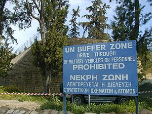
United Nations Buffer Zone in Cyprus
Encyclopedia
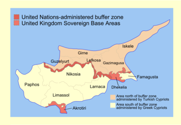
Sovereign Base Areas
The Sovereign Base Areas are military bases located on territory in which the United Kingdom is sovereign, but which are separated from the ordinary British territory....
), and the northern area controlled by the Turkish army.
The term Green Line refers to the cease fire line
Ceasefire
A ceasefire is a temporary stoppage of a war in which each side agrees with the other to suspend aggressive actions. Ceasefires may be declared as part of a formal treaty, but they have also been called as part of an informal understanding between opposing forces...
that de facto divides the island nation
Island nation
An island country is a state whose primary territory consists of one or more islands or parts of islands. As of 2011, 47 of the 193 UN member states are island countries.-Politics:...
of Cyprus into two, cutting through the capital of Nicosia
Nicosia
Nicosia from , known locally as Lefkosia , is the capital and largest city in Cyprus, as well as its main business center. Nicosia is the only divided capital in the world, with the southern and the northern portions divided by a Green Line...
. It was first established in 1964, when Major-General Peter Young
Peter Young (British Army officer)
Major General Peter George Francis Young CB CBE was a senior British Army officer who was General Officer Commanding Cyprus District from 1962 to 1964.-Military career:...
was the commander of a "peace force", a predecessor of the present UNFICYP. After stationing his troops in different areas of Nicosia, the general drew a cease-fire line on a map with a dark green crayon
Crayon
A crayon is a stick of colored wax, charcoal, chalk, or other materials used for writing, coloring, drawing, and other methods of illustration. A crayon made of oiled chalk is called an oil pastel; when made of pigment with a dry binder, it is simply a pastel; both are popular media for color...
, which was to become known as the "Green Line".
The Green Line became impassable following the July 1974 invasion
Turkish invasion of Cyprus
The Turkish invasion of Cyprus, launched on 20 July 1974, was a Turkish military invasion in response to a Greek military junta backed coup in Cyprus...
by Turkey which intervened by air, sea, and land, capturing approximately 8% of Cyprus territory in response to a short lived Greek Cypriot coup. When the coup dissolved, the Turkish Armed Forces
Turkish Armed Forces
The Turkish Armed Forces are the military forces of the Republic of Turkey. They consist of the Army, the Navy , and the Air Force...
advanced to capture approximately 37% of the island and meet the "Green Line". The meander
Meander
A meander in general is a bend in a sinuous watercourse. A meander is formed when the moving water in a stream erodes the outer banks and widens its valley. A stream of any volume may assume a meandering course, alternately eroding sediments from the outside of a bend and depositing them on the...
ing green line marks the southernmost points that the Turkish troops occupied during the Turkish Invasion of Cyprus
Turkish invasion of Cyprus
The Turkish invasion of Cyprus, launched on 20 July 1974, was a Turkish military invasion in response to a Greek military junta backed coup in Cyprus...
in 16 August 1974. With the self-proclamation
Declaration of Independence of the Turkish Republic of Northern Cyprus
Eight years after the Turkish Federative State of North Cyprus was proclaimed , the UDI of North Cyprus was presented to the Northern Cypriot Parliament in North Nicosia by Turkish Cypriot Leader/Northern Cypriot State President Rauf Denktaş on November 15, 1983...
of the internationally unrecognized Turkish Republic of Northern Cyprus, the Green Line became its de facto southern border.
This line is also referred to as the Attila Line on some maps, named after the Turkish code-name for the 1974 military intervention: Operation Atilla
Operation Atilla
Attila Operations refers to the two operations performed by the Turkish Armed Forces during the invasion of Cyprus.Atilla I was the first stage of the operation. The invasion began in the early hours of 20 July 1974 in response to a Greek-inspired coup d'etat that sought to overthrow the...
. The closed off zone has become a haven for Cyprus' wildlife, an example of an involuntary park
Involuntary park
Involuntary park is a neologism coined by science fiction author and environmentalist Bruce Sterling to describe previously inhabited areas that for environmental, economic or political reasons have, in Sterling's words, "lost their value for technological instrumentalism" and been allowed to...
.
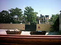
Traffic across the buffer zone was very limited until 2003, when the number of crossings and the rules governing them were relaxed.
The buffer zone
Nicosia
Nicosia from , known locally as Lefkosia , is the capital and largest city in Cyprus, as well as its main business center. Nicosia is the only divided capital in the world, with the southern and the northern portions divided by a Green Line...
, separating the city into southern and northern sections. There is also a buffer zone around the Kokkina exclave
Kokkina exclave
Kokkina is an exclave of the internationally unrecognised Turkish Republic of Northern Cyprus. It was one of the Turkish Cypriot enclaves prior to the Turkish invasion of Cyprus in 1974. It is hemmed in on three sides by mountainous territory controlled by the Republic of Cyprus with the...
in western Cyprus. The width of the zone ranges from 3.3 metres (10.8 ft) in central Nicosia, to 7.4 kilometres (4.6 mi) at the village of Athienou
Athienou
Athienou is a village in Larnaca District, Cyprus. It is one of only four villages located within the United Nations Buffer Zone, the other three being Pyla, Troulloi and Deneia...
.
There is no buffer zone along the common border between the eastern British Sovereign Base Area and the area under Turkish Cypriot control.
The buffer zone is patrolled by the United Nations Peacekeeping Force in Cyprus
United Nations Peacekeeping Force in Cyprus
The United Nations Peacekeeping Force in Cyprus was established in 1964 to prevent a recurrence of fighting between the Greek Cypriots and Turkish Cypriots and to contribute to the maintenance and restoration of law and order and a return to normal conditions...
. Turkish forces built a barrier on the zone's northern side, consisting mainly of barbed-wire fencing, concrete wall segments, watchtowers, anti-tank ditches, and minefields.
The buffer zone is home to some 10,000 people and there are several villages and farms located within. The village of Pyla
Pyla
Pyla is a village in Larnaca District, Cyprus. It is one of only four villages located within the United Nations Buffer Zone, the other three being Athienou, Troulloi and Deneia. Pyla is located in the eastern part of the island, adjacent to the British Sovereign Base Area of Dhekelia...
is famous for being the only village on Cyprus where Greeks and Turks live side by side. Other villages are Dhenia, Mammari, Athienou
Athienou
Athienou is a village in Larnaca District, Cyprus. It is one of only four villages located within the United Nations Buffer Zone, the other three being Pyla, Troulloi and Deneia...
, Troulli while Lymbia lies partially within the zone.
History
Geneva
Geneva In the national languages of Switzerland the city is known as Genf , Ginevra and Genevra is the second-most-populous city in Switzerland and is the most populous city of Romandie, the French-speaking part of Switzerland...
in July 1974. Pursuant to United Nations Security Council Resolution 353
United Nations Security Council Resolution 353
United Nations Security Council Resolution 353, adopted unanimously on July 20, 1974, in response to the Turkish invasion of Cyprus, the Council demanded the immediate withdrawal of all foreign military personnel present in the Republic of Cyprus in contravention of paragraph 1 of the United...
(1974), the foreign ministers of Greece, Turkey, and the United Kingdom convened in Geneva, Switzerland on 25 July 1974. According to UNFICYP, the text of the joint declaration transmitted to the Secretary-General
Secretary-General
-International intergovernmental organizations:-International nongovernmental organizations:-Sports governing bodies:...
of the United Nations was as follows:
A security zone of a size to be determined by representatives of Greece, Turkey, and the United Kingdom, in consultation with UNFICYP, was to be established at the limit of the areas occupied by the Turkish armed forces. This zone was to be entered by no forces other than those of UNFICYP, which was to supervise the prohibition of entry. Pending the determination of the size and character of the security zone, the existing area between the two forces was not to be breached by any forces.
Crossings
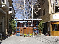
Ledra Palace
The Ledra Palace Hotel is located in central Nicosia, Cyprus, and until 1974 was one of the largest and most glamorous hotels of the capital. The Hotel was built in 1949 and had a de luxe rating. All rooms had hot and cold water, central heating and a telephone. Facilities included a conference,...
just outside the walls of old Nicosia. This was made only possible after the decision of the ECHR (Djavit An vs Turkey, Application No.20652/92).
These are the crossings now available :
| Republic of Cyprus entrance | Turkish Republic of Northern Cyprus entrance | Notes |
|---|---|---|
| Astromeritis Astromeritis Astromeritis is a large village in the Morphou Department of the Nicosia District of Cyprus. It is located from the capital Nicosia... Αστρομερίτης (Greek) |
Zodeia Zodeia Zodeia is a village on the island of Cyprus. It is located east of Morphou in Nicosia District. It is in the northern part of the island which has been occupied by Turkey since August 15, 1974... Ζώδεια (Greek) Bostancı (Turkish Turkish language Turkish is a language spoken as a native language by over 83 million people worldwide, making it the most commonly spoken of the Turkic languages. Its speakers are located predominantly in Turkey and Northern Cyprus with smaller groups in Iraq, Greece, Bulgaria, the Republic of Macedonia, Kosovo,... ) |
By car only |
| Ayios Dhometios | Metehan Metehan Metehan is a common masculine Turkish given name. "Metehan" is composed of two words: "Mete" and "Han". In Turkish, "Mete" means "brave", "galahad", "hero", "valiant", and/or "gallant" whereas "Han" means literally "Khan"... |
|
| Ledra Palace Ledra Palace The Ledra Palace Hotel is located in central Nicosia, Cyprus, and until 1974 was one of the largest and most glamorous hotels of the capital. The Hotel was built in 1949 and had a de luxe rating. All rooms had hot and cold water, central heating and a telephone. Facilities included a conference,... |
Ledra Palace Ledra Palace The Ledra Palace Hotel is located in central Nicosia, Cyprus, and until 1974 was one of the largest and most glamorous hotels of the capital. The Hotel was built in 1949 and had a de luxe rating. All rooms had hot and cold water, central heating and a telephone. Facilities included a conference,... |
|
| Ledra Street Ledra Street Ledra Street is a major shopping thoroughfare in central Nicosia, Cyprus, which links North and South Nicosia.... οδός Λήδρας (Greek) Lokmacı Caddesi (Turkish Turkish language Turkish is a language spoken as a native language by over 83 million people worldwide, making it the most commonly spoken of the Turkic languages. Its speakers are located predominantly in Turkey and Northern Cyprus with smaller groups in Iraq, Greece, Bulgaria, the Republic of Macedonia, Kosovo,... ) |
Ledra Street Ledra Street Ledra Street is a major shopping thoroughfare in central Nicosia, Cyprus, which links North and South Nicosia.... οδός Λήδρας (Greek) Lokmacı Caddesi (Turkish Turkish language Turkish is a language spoken as a native language by over 83 million people worldwide, making it the most commonly spoken of the Turkic languages. Its speakers are located predominantly in Turkey and Northern Cyprus with smaller groups in Iraq, Greece, Bulgaria, the Republic of Macedonia, Kosovo,... ) |
On foot only |
| Pyla Pyla Pyla is a village in Larnaca District, Cyprus. It is one of only four villages located within the United Nations Buffer Zone, the other three being Athienou, Troulloi and Deneia. Pyla is located in the eastern part of the island, adjacent to the British Sovereign Base Area of Dhekelia... Πύλα (Greek) Pile (Turkish Turkish language Turkish is a language spoken as a native language by over 83 million people worldwide, making it the most commonly spoken of the Turkic languages. Its speakers are located predominantly in Turkey and Northern Cyprus with smaller groups in Iraq, Greece, Bulgaria, the Republic of Macedonia, Kosovo,... ) |
Pergamos Pergamos, Cyprus Pergamos is a village located in the Larnaca District of Cyprus. The town is situated in the part of the island controlled by the de facto Turkish Republic of Northern Cyprus and is the site of a Green Line crossing checkpoint.... Πέργαμoς (Greek) Beyarmudu (Turkish Turkish language Turkish is a language spoken as a native language by over 83 million people worldwide, making it the most commonly spoken of the Turkic languages. Its speakers are located predominantly in Turkey and Northern Cyprus with smaller groups in Iraq, Greece, Bulgaria, the Republic of Macedonia, Kosovo,... ) |
|
| Agios Nikolaos Άγιος Νικόλαος (Greek) |
Strovilia Strovilia Strovilia is a small village located right at the border of the de facto Turkish Republic of Northern Cyprus with the British Sovereign Base Area of Dhekelia. It is the site of a Green Line crossing.... Akyar (Turkish Turkish language Turkish is a language spoken as a native language by over 83 million people worldwide, making it the most commonly spoken of the Turkic languages. Its speakers are located predominantly in Turkey and Northern Cyprus with smaller groups in Iraq, Greece, Bulgaria, the Republic of Macedonia, Kosovo,... ) |
|
| Limnitis Limnitis Limnitis is a village in the Tilliria region in Nicosia District, North Western Cyprus. The ancient Vouni Palace was located nearby. It is a small village located on the shores of the Morphou Bay... Λιμνίτης (Greek) Yeşilırmak (Turkish Turkish language Turkish is a language spoken as a native language by over 83 million people worldwide, making it the most commonly spoken of the Turkic languages. Its speakers are located predominantly in Turkey and Northern Cyprus with smaller groups in Iraq, Greece, Bulgaria, the Republic of Macedonia, Kosovo,... ) |
Limnitis Limnitis Limnitis is a village in the Tilliria region in Nicosia District, North Western Cyprus. The ancient Vouni Palace was located nearby. It is a small village located on the shores of the Morphou Bay... Λιμνίτης (Greek) Yeşilırmak (Turkish Turkish language Turkish is a language spoken as a native language by over 83 million people worldwide, making it the most commonly spoken of the Turkic languages. Its speakers are located predominantly in Turkey and Northern Cyprus with smaller groups in Iraq, Greece, Bulgaria, the Republic of Macedonia, Kosovo,... ) |
Before Cypriot accession to the European Union
European Union
The European Union is an economic and political union of 27 independent member states which are located primarily in Europe. The EU traces its origins from the European Coal and Steel Community and the European Economic Community , formed by six countries in 1958...
, there were restrictions on Green Line crossings by foreigners imposed by the Republic of Cyprus, but these were abolished for EU citizens by EU-regulation
European Union regulation
A regulation is a legislative act of the European Union that becomes immediately enforceable as law in all member states simultaneously. Regulations can be distinguished from directives which, at least in principle, need to be transposed into national law...
866/2004. Generally, citizens of any country are permitted to cross the line, including Greek and Turkish Cypriots. Passports are required for entry into Northern Cyprus, but they are not stamped.
Incidents
In August 1996, Greek Cypriot refugees demonstrated with a march against what they regard as the Turkish occupationTurkish Republic of Northern Cyprus
Northern Cyprus or North Cyprus , officially the Turkish Republic of Northern Cyprus , is a self-declared state that comprises the northeastern part of the island of Cyprus...
of Cyprus. The demonstrators' demand was the complete withdrawal of Turkish troops and the return of the refugees to their homes and properties.
Another man, Solomos Solomou
Solomos Solomou
Solomos Solomou , was a Greek Cypriot refugee who was killed after being shot five times by Turkish forces while trying to climb a flagpole in order to remove a Turkish flag from its mast in the United Nations Buffer Zone near Deryneia, Cyprus...
, was shot by Turkish troops during the same protests on 14 August 1996.
Aged 26, Solomou was one of many mourners who entered the Buffer Zone three days after Isaac's funeral, on 14 August to lay a wreath on the spot where he had been beaten to death. Solomou was fired upon by Turkish soldiers at close range as he climbed a flagpole. An investigation followed by authorities of the Republic of Cyprus and the suspects were named as Kenan Akin and Erdan Emanet. International legal proceedings were instigated and arrest warrants for both were issued via Interpol
Interpol
Interpol, whose full name is the International Criminal Police Organization – INTERPOL, is an organization facilitating international police cooperation...
.
See also
- United Nations High Commissioner for Refugees Representation in CyprusUnited Nations High Commissioner for Refugees Representation in CyprusThe United Nations High Commissioner for Refugees Representation in Cyprus is an office of the United Nations High Commissioner for Refugees opened in August 1974 upon the request of the Government of Cyprus and the Secretary-General of the United Nations...
- No man's landNo man's landNo man's land is a term for land that is unoccupied or is under dispute between parties that leave it unoccupied due to fear or uncertainty. The term was originally used to define a contested territory or a dumping ground for refuse between fiefdoms...
- Cyprus disputeCyprus disputeThe Cyprus dispute is the result of the ongoing conflict between the Republic of Cyprus and Turkey, over the Turkish occupied northern part of Cyprus....
- Cypriot refugees
- Sovereign Base Areas CustomsSovereign Base Areas CustomsSovereign Base Areas Customs is a semi-autonomous branch of UK Customs with jurisdiction over Akrotiri and Dhekelia, a British Overseas Territory on the island of Cyprus, administered as a Sovereign Base Area, and home to British Forces Cyprus. It is managed by the MoD and around 3500 military...
- PylaPylaPyla is a village in Larnaca District, Cyprus. It is one of only four villages located within the United Nations Buffer Zone, the other three being Athienou, Troulloi and Deneia. Pyla is located in the eastern part of the island, adjacent to the British Sovereign Base Area of Dhekelia...
- Louroujina SalientLouroujina SalientThe Louroujina Salient marks the southernmost extent of North Cyprus. It is named after the Turkish Cypriot village of Louroujina. Akıncılar was one of the biggest Turkish Cypriot villages in Cyprus before the division of the island....
- Kokkina exclaveKokkina exclaveKokkina is an exclave of the internationally unrecognised Turkish Republic of Northern Cyprus. It was one of the Turkish Cypriot enclaves prior to the Turkish invasion of Cyprus in 1974. It is hemmed in on three sides by mountainous territory controlled by the Republic of Cyprus with the...
- Merlijn TwaalfhovenMerlijn TwaalfhovenMerlijn Twaalfhoven is a Dutch composer and theatre maker. He graduated from the Conservatorium van Amsterdam in 2003. Twaalfhoven is internationally active in creating innovative projects and writing new music for orchestras, choirs and chamber music groups...
, did a project in NicosiaNicosiaNicosia from , known locally as Lefkosia , is the capital and largest city in Cyprus, as well as its main business center. Nicosia is the only divided capital in the world, with the southern and the northern portions divided by a Green Line...
with musicians from both sides of the border.
External links
- Maps of the Buffer Zone, from the UNFICYP website
- Associated Press: Barriers Slowly Eroding for Cyprus
- Beyond the Buffer Zone: One Woman's vision for bringing new life to the No-Man's Land
- Nicosia in Dark and White A photo project about the abandoned buildings around the Green Line
- The United Nations Force in Cyprus Since 1964
- EU Commission report on implementation of the Green Line Regulation (14 July 2005)
- EU Green Line Regulation (29 April 2004)
- Twaalfhoven.net
- [http://www.urban-travel.org/greenline/ Photos from within the Green Line]
Long Distance Call Project in Cyprus, see Documentaries below
Documentaries
- Echoes Across the Divide (2008) is a documentary film about an attempt to bridge the Green Line with a bicommunal music project performed from the rooftops of Old Nicosia