

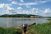
Ubangi River
Encyclopedia
Tributary
A tributary or affluent is a stream or river that flows into a main stem river or a lake. A tributary does not flow directly into a sea or ocean...
of the Congo River
Congo River
The Congo River is a river in Africa, and is the deepest river in the world, with measured depths in excess of . It is the second largest river in the world by volume of water discharged, though it has only one-fifth the volume of the world's largest river, the Amazon...
of Central Africa
Central Africa
Central Africa is a core region of the African continent which includes Burundi, the Central African Republic, Chad, the Democratic Republic of the Congo, and Rwanda....
. It begins at the confluence of the Mbomou
Mbomou River
The Mbomou River or Bomu forms part of the boundary between the Central African Republic and the Democratic Republic of the Congo ....
and Uele River
Uele River
The Uele River, also spelled Welle River, is a river in the Democratic Republic of the Congo. It originates in the mountains near Lake Albert and flows west for about to join the Mbomou River at Yakoma....
s and flows west, then bends to the southwest and passes through Bangui
Bangui
-Law and government:Bangui is an autonomous commune of the Central African Republic. With an area of 67 km², it is by far the smallest high-level administrative division of the CAR in area but the highest in population...
, after which it flows south to the Congo at Liranga. The Ubangi's length is about 1060 kilometres (658.7 mi). Its total length with the Uele, its longest tributary, is 2270 kilometres (1,410.5 mi). The Ubangi's drainage basin
Drainage basin
A drainage basin is an extent or an area of land where surface water from rain and melting snow or ice converges to a single point, usually the exit of the basin, where the waters join another waterbody, such as a river, lake, reservoir, estuary, wetland, sea, or ocean...
is about 772800 square kilometres (298,379.7 sq mi) and includes portions of the Democratic Republic of the Congo
Democratic Republic of the Congo
The Democratic Republic of the Congo is a state located in Central Africa. It is the second largest country in Africa by area and the eleventh largest in the world...
, Central African Republic
Central African Republic
The Central African Republic , is a landlocked country in Central Africa. It borders Chad in the north, Sudan in the north east, South Sudan in the east, the Democratic Republic of the Congo and the Republic of the Congo in the south, and Cameroon in the west. The CAR covers a land area of about ,...
, and Republic of Congo. Its discharge
Discharge (hydrology)
In hydrology, discharge is the volume rate of water flow, including any suspended solids , dissolved chemical species and/or biologic material , which is transported through a given cross-sectional area...
at Bangui ranges from about 800 m3/s to 11000 m3/s, with an average flow of about 4000 m3/s.
Together with the Congo River, it provides an important transport artery for river boats between Bangui and Brazzaville
Brazzaville
-Transport:The city is home to Maya-Maya Airport and a railway station on the Congo-Ocean Railway. It is also an important river port, with ferries sailing to Kinshasa and to Bangui via Impfondo...
.
From its source to 100 kilometres (62.1 mi) below Bangui, the Ubangi defines the boundary between the Central African Republic and the Democratic Republic of the Congo (DRC). Thereafter, it forms the boundary between the DRC and the Republic of Congo until it empties into the Congo River.
In the 1960s, a plan was proposed to divert waters from the Ubangi to the Chari River
Chari River
The Chari or Shari River is a 949-kilometer-long river of central Africa. It flows from the Central African Republic through Chad into Lake Chad, following the Cameroon border from N'Djamena, where it joins the Logone River waters....
which empties into Lake Chad
Lake Chad
Lake Chad is a historically large, shallow, endorheic lake in Africa, whose size has varied over the centuries. According to the Global Resource Information Database of the United Nations Environment Programme, it shrank as much as 95% from about 1963 to 1998; yet it also states that "the 2007 ...
. According to the plan, the water from the Ubangi would revitalize that lake and provide livelihood in fishing and enhanced agriculture to tens of millions of central Africans and Sahel
Sahel
The Sahel is the ecoclimatic and biogeographic zone of transition between the Sahara desert in the North and the Sudanian Savannas in the south.It stretches across the North African continent between the Atlantic Ocean and the Red Sea....
ians. Inter-basin water transfer schemes were proposed in the 1980s and 1990s by Nigerian engineer J. Umolu (ZCN Scheme) and Italian firm Bonifica (Transaqua Scheme). In 1994, the Lake Chad Basin Commission (LCBC) proposed a similar project and at a March 2008 summit, the heads of state
Head of State
A head of state is the individual that serves as the chief public representative of a monarchy, republic, federation, commonwealth or other kind of state. His or her role generally includes legitimizing the state and exercising the political powers, functions, and duties granted to the head of...
of the LCBC member countries committed to the diversion project. In April, 2008, the LCBC advertised a request for proposals for a feasibility study.