

U.S. Route 6 in Rhode Island
Encyclopedia
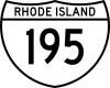
- Route 195 redirects here. For the route currently numbered 195, see Interstate 195 (Rhode Island).
U.S. Route 6 is a major east–west road in the U.S. state
U.S. state
A U.S. state is any one of the 50 federated states of the United States of America that share sovereignty with the federal government. Because of this shared sovereignty, an American is a citizen both of the federal entity and of his or her state of domicile. Four states use the official title of...
of Rhode Island
Rhode Island
The state of Rhode Island and Providence Plantations, more commonly referred to as Rhode Island , is a state in the New England region of the United States. It is the smallest U.S. state by area...
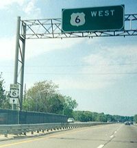
. Nationally, the route continues west to Bishop, California
Bishop, California
Bishop is a city in Inyo County, California, United States. Though Bishop is the only city and the largest populated place in Inyo County, the county seat is Independence. Bishop is located near the northern end of the Owens Valley, at an elevation of 4147 feet . The population was 3,879 at the...
and east to Provincetown, Massachusetts
Provincetown, Massachusetts
Provincetown is a New England town located at the extreme tip of Cape Cod in Barnstable County, Massachusetts, United States. The population was 3,431 at the 2000 census, with an estimated 2007 population of 3,174...
. In western Rhode Island, it forms part of one of several routes between Hartford, Connecticut
Hartford, Connecticut
Hartford is the capital of the U.S. state of Connecticut. The seat of Hartford County until Connecticut disbanded county government in 1960, it is the second most populous city on New England's largest river, the Connecticut River. As of the 2010 Census, Hartford's population was 124,775, making...
and Providence, Rhode Island
Providence, Rhode Island
Providence is the capital and most populous city of Rhode Island and was one of the first cities established in the United States. Located in Providence County, it is the third largest city in the New England region...
, and was planned to be replaced by Interstate 84. The part of I-84 that was built, from Interstate 295 to Olneyville, is now part of US 6. At Olneyville, US 6 joins Route 10 and heads east towards downtown Providence, where it turns south on Interstate 95 and east on Interstate 195. US 6 splits from I-195 in East Providence, crossing into Massachusetts
Massachusetts
The Commonwealth of Massachusetts is a state in the New England region of the northeastern United States of America. It is bordered by Rhode Island and Connecticut to the south, New York to the west, and Vermont and New Hampshire to the north; at its east lies the Atlantic Ocean. As of the 2010...
on Warren Avenue. The whole route of US 6 is a state highway
State highway
State highway, state road or state route can refer to one of three related concepts, two of them related to a state or provincial government in a country that is divided into states or provinces :#A...
maintained by the Rhode Island Department of Transportation
Rhode Island Department of Transportation
The Rhode Island Department of Transportation is a Rhode Island state government agency charged with construction, maintenance and inspection of a wide range of transportation infrastructure. These include 1,102 miles of state roads and highways, 772 bridges, and 777 traffic signals...
.
Route description
US 6 crosses from Killingly, ConnecticutKillingly, Connecticut
Killingly is a town in Windham County, Connecticut, United States. The population was 16,472 at the 2000 census. It consists of the borough of Danielson and the villages of Attawaugan, Ballouville, Dayville, East Killingly, Rogers, and South Killingly....
into Foster, Rhode Island
Foster, Rhode Island
Foster is a town in Providence County, Rhode Island, in the United States. The population was 4,606 at the 2010 census.- History :Foster was originally settled in the 17th century by British colonists as a farming community...
just east of the end of the Governor John Davis Lodge Turnpike, formerly known as the Connecticut Turnpike
Connecticut Turnpike
The Connecticut Turnpike, known now as the Governor John Davis Lodge Turnpike, is a freeway in Connecticut that runs from Greenwich to Killingly. It is signed as Interstate 95 from the New York state line at Greenwich to East Lyme, and then as Interstate 395 from East Lyme to Plainfield...
(State Road 695). That part of US 6 was once the Foster and Scituate Turnpike, now called the Danielson Pike. It crosses Route 94 in Foster before crossing into Scituate.
Soon after entering Scituate, US 6 splits into bypass
Bypass (road)
A bypass is a road or highway that avoids or "bypasses" a built-up area, town, or village, to let through traffic flow without interference from local traffic, to reduce congestion in the built-up area, and to improve road safety....
and business alignments. The business alignment runs further south along the old turnpike, and is mostly signed as US 6 without a banner. The bypass is signed mostly as BY-PASS US 6 on sign assemblies but as bannerless US 6 on green guide signs. Most maps and information takes US 6 along the bypass.
Scituate Reservoir
The Scituate Reservoir is the largest inland body of water in the state of Rhode Island. It has an aggregate capacity of and a surface area of 5.3 square miles...
and Route 116 before they merge near the east edge of Scituate. This merge was the east end of the Foster and Scituate Turnpike, and was the east end of Route 101 until the early 2000s (when it was truncated to the merge with US 6 Bypass). (The Rhode Island and Connecticut Turnpike continued to the Olneyville section of Providence, where it is known as Hartford Avenue.)
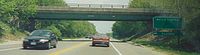
Soon after the bypass and business routes merge, US 6 enters Johnston. Several miles later it intersects with Interstate 295. From I-295 to Olneyville, the old road — Hartford Avenue — is now U.S. Route 6A, as US 6 uses the Dennis J. Roberts Expressway. To get there, it turns south on the I-295 collector/distributor roads to the west end of that freeway. The south interchange http://maps.google.com/maps?ll=41.820775,-71.512649&spn=0.00694,0.021458&t=h&om=1 of US 6 and I-295 has numerous ramp stubs once intended for a western continuation of the Roberts Expressway as Interstate 84.
The six-lane Roberts Expressway has interchange
Interchange (road)
In the field of road transport, an interchange is a road junction that typically uses grade separation, and one or more ramps, to permit traffic on at least one highway to pass through the junction without directly crossing any other traffic stream. It differs from a standard intersection, at which...
s with Route 5, U.S. Route 6A, Route 128, and US 6A again on its way to Olneyville. It crosses from Johnston into Providence just west of the bridge over Route 128. At the second US 6A interchange, the older Olneyville Bypass begins, and the freeway reduces to four lanes. Heading around Olneyville to the south and east, US 6 has partial interchanges with Route 14, Route 10 and Broadway before merging with Route 10 towards downtown Providence on the Route 6-10 Connector. Along the Connector is an interchange with Dean Street before it (and Route 10) ends at Interstate 95, with ramps to Memorial Boulevard for downtown access. US 6 turns south there with I-95. US 6 soon leaves I-95 for Interstate 195, which takes it east across the south side of downtown. U.S. Route 1A and U.S. Route 44 join after it crosses the Providence River
Providence River
thumb|The city of Providence as seen from the Providence River at its confluence with the Narragansett BayThe Providence River is a tidal river in the U.S. state of Rhode Island. It flows approximately 8 miles...
, and the four routes head east across the Washington Bridge
Washington Bridge (Providence)
The Washington Bridge is a paired bridge carrying Interstate 195 over the Seekonk River from Providence to East Providence, Rhode Island.- History :...
over the Seekonk River
Seekonk River
The Seekonk River is a tidal extension of the Providence River in the U.S. state of Rhode Island. It flows approximately 8 km . Most historical scholars agree that the name is derived from two Native American words, sucki and honc...
.
Upon crossing the Washington Bridge, US 6 enters East Providence. US 44 leaves onto Taunton Avenue at the east end of the bridge, and Route 103 - the old alignment of US 6 - begins on Warren Avenue. (Some signs still mark Warren Avenue as US 6, but signs in both directions on US 6 keep it on I-195.) After interchanges with Broadway and Pawtucket Avenue — the latter carrying Route 114 in both directions and U.S. Route 1A to the north — US 6 splits from I-195 at the interchange with the East Shore Expressway (signed for Route 114 south). It takes the ramps towards Warren Avenue, which it uses most of the way to the state line before heading southeast on Highland Avenue to cross into Seekonk, Massachusetts
Seekonk, Massachusetts
Seekonk is a town in Bristol County, Massachusetts, United States, on the Massachusetts border. It was incorporated in 1812 from the western half of Rehoboth. The population was 13,722 at the 2010 census. Until 1862, the town of Seekonk also included what is now the City of East Providence, Rhode...
.
History

New England Interstate Routes
The New England road marking system was an interstate system of marked numbered routes in New England. The routes were marked by a yellow rectangular shield with black numbers and border. Many shields were painted on telephone poles...
, designated in 1922. The part of Route 3 in Rhode Island ran roughly how US 6 does now; the main differences were in Scituate (where it used US 6 Business) and from Johnston east through Providence and East Providence (where it used US 6A, Broadway, Washington Street, Waterman Street, the old Red Bridge and Waterman Avenue, and then turned south on Pawtucket Avenue and east along current Route 103 to reach Massachusetts).
By the time Route 3 became U.S. Route 6 in late 1926, it had been moved to use Waterman Avenue through East Providence to Massachusetts. (In Massachusetts, US 6 turned south on present Route 114A to reach its current alignment.) Waterman Street in Providence had become one-way eastbound by 1930; westbound US 6 came off the Red Bridge and turned north on River Street, west on South Angell Street and Angell Street, and south on Benefit Street.
At some point, possibly by 1929, US 6 had moved from the Red Bridge to the Washington Bridge
Washington Bridge (Providence)
The Washington Bridge is a paired bridge carrying Interstate 195 over the Seekonk River from Providence to East Providence, Rhode Island.- History :...
. In downtown Providence, it turned south on Main Street and east on Fox Point Boulevard (now Interstate 195) to reach the bridge, taking Taunton Avenue (now U.S. Route 44) into Massachusetts (where it turned south on present Route 114A).
US 6 was realigned to bypass downtown to the south via the Point Street Bridge by 1942. It came along Westminster Street from Olneyville, turning southeast on Winter Street (now Fricker Street) and Lockwood Street. A short one-way pair
One-way pair
A one-way pair, one-way couple, or just couplet is a pair of parallel, usually one-way streets that carry opposite directions of a signed route or major traffic flow, or sometimes opposite directions of a bus or streetcar route....
on Lockwood Street and Friendship Street (eastbound) and Pine Street and Summer Street (westbound) led to Point Street and over the bridge of the same name to the west end of Fox Point Boulevard. Upon coming off the Washington Bridge, instead of heading northeast on Taunton Avenue, it had been moved to the more direct Warren Avenue by 1942.
When the Olneyville Bypass opened in 1953, US 6 was rerouted to use it. Eastbound US 6 simply exited the bypass onto Westminster Street to rejoin its old route, but westbound US 6 used a totally different route. It turned northwest on Main Street instead of crossing the Point Street Bridge, and turned west at Waterman Street to reach Promenade Street, then passing through the large rotary north of Union Station
Union Station (Providence)
Union Station describes two distinct defunct train stations in Providence, Rhode Island.The original Union Station was Providence's first, opening in 1847 to accommodate the needs of the newly thriving city. It was considered "a brilliant example of Romanesque architecture" in its time, and the...
onto Kinsley Avenue. (Kinsley Avenue was later one-way eastbound in that area, so US 6 west continued on Promenade Street from the rotary, crossing to Kinsley Avenue somewhere to the west.
When the Broad Freeway - the section of Interstate 195 south of downtown — opened in 1958, it replaced part of eastbound US 6. Instead of turning east on Point Street, US 6 instead continued northeast on Friendship Street to reach the freeway. In 1963 and 1964, Interstate 95 was opened at the west end of I-195; the eastbound entrance from Friendship was slightly moved but otherwise remained the same. To the east of the Washington Bridge, the East Providence Expressway - another section of I-195 - opened in 1959. Maps (and even some current signage) disagree about whether US 6 moved to the new bypass at that point or remained on Warren Avenue.
To the west of the Providence area, the three-lane bypass (1 lane eastbound, 2 westbound) of Scituate opened ca. 1966. This road is signed with US 6 Bypass signs, while the old route is still signed as US 6.
In downtown Providence, US 6 was moved in 1988 with the opening of the Route 6-10 Connector between Olneyville and downtown. US 6 was moved off the long one-way pair
One-way pair
A one-way pair, one-way couple, or just couplet is a pair of parallel, usually one-way streets that carry opposite directions of a signed route or major traffic flow, or sometimes opposite directions of a bus or streetcar route....
and onto the Connector, turning south on Interstate 95 and east on Interstate 195. With the construction of the Iway
Iway
The Iway is the $610 million project by the Rhode Island Department of Transportation to relocate the Interstate 195 and Interstate 95 intersection in Providence, Rhode Island...
, traffic will be rerouted to the south.
Exit list
| Municipality | Mile | Destinations | Notes |
|---|---|---|---|
| Johnston | , Hartford Hartford, Connecticut Hartford is the capital of the U.S. state of Connecticut. The seat of Hartford County until Connecticut disbanded county government in 1960, it is the second most populous city on New England's largest river, the Connecticut River. As of the 2010 Census, Hartford's population was 124,775, making... |
westbound exit and eastbound entrance | |
| Providence | westbound exit and eastbound entrance | ||
| westbound exit and eastbound entrance | |||
| no westbound entrance | |||
| Broadway | eastbound exit and westbound entrance | ||
| Dean Street, Atwells Avenue Providence Place Providence Place Providence Place is an urban shopping mall in the central part of Providence, Rhode Island. Opened on August 20, 1999, it is located near the Rhode Island State House and Providence Station. It compromises three main floors and is connected to the nearby Westin Hotel via skyway. It also features... |
exit 22C westbound (from the I-95 ramps) | ||
| Downtown Providence (Memorial Boulevard) | eastbound exit and westbound entrance | ||
| New York, Boston, Cape Cod | eastbound exit and westbound entrance |