

U.S. Route 67 in Arkansas
Encyclopedia
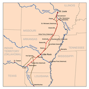
U.S. Route 67 in Arkansas runs from Texarkana
to the Missouri
state line in Northeastern Arkansas.
, where it then runs concurrent
with I-30 to North Little Rock
. It then runs east, concurrent with I-40, for about 2 miles (3.2 km), then branches off to the northeast as a freeway to near Swifton
. Temporarily, US-67 travels west for about 6 miles (9.7 km) along Highway 226
at the end of the freeway to its old 2-lane alignment, where it continues north toward Hoxie
. Just south of Hoxie, US-67 is routed east along the US-63 bypass for a short distance, then north on a short section of freeway bypassing Hoxie and Walnut Ridge
. This section of freeway will eventually be connected to the interstate-style freeway that currently ends at Arkansas Highway 226. It is currently under construction and will open in the next two to three years.
Just north of US-412, the freeway ends at a large, partially complete interchange, and US-67 becomes a five-lane undivided highway north to Pocahontas
. From Pocahontas, US-67 turns northeasterly as a two-lane highway to Corning
with a concurrency with US 62, then turns north again and crosses into Missouri.
 The southwest-northeast bisector of Arkansas has always been an integral motor route. Prior to designation as US 67, the route was known as the Southwest Trail
, an old military road around 1803. The Southwest Trail connected St. Louis, Missouri
with Texas
by steamboat
in Fulton, Arkansas
. The main railroad was built along the Southwest Trail, which developed many towns along the route. President Andrew Jackson
appropriated money for the route in 1831, and designated it as a National Road. Although the route shifted slightly, it always has followed the natural break between the Ozark Mountains and the Ouachita Mountains
.
Money for road maintenance was raised individually by county in the early 20th century, which hindered development of the route. In the 1920s, federal money became available, and the route was designated U.S. Route 67. The routing followed the Lakes to Gulf Highway and the Bankhead Highway
. Federal designation brought paving to the route, which grew the small towns along the route.
In early 2009, the Arkansas legislature passed a bill naming the portion of US-67 from the Missouri state line to Jackson County "Rock n' Roll U.S. 67" as a tribute to the route that many musicians of the 1950s and 1960s took as they traveled. Governor Mike Beebe stated that he had hopes that the naming would bring tourism to northeast Arkansas. Porton of the route, and also Arkansas Highway 7 between Hope
and Hot Springs
frequently used by Bill Clinton
is designated The Highway of Hope by Arkansas Code § 27-67-220.
On October 10, 2009, the freeway portion of US-67 was extended 17 miles (27.4 km) north of Newport to the junction of Highway 226 between Cash
and Swifton.
-standard freeway from Little Rock to the Missouri state line. As of 2011, it is finished from Little Rock to Highway 226 between Cash and Swifton. Construction is underway to extend the freeway to the U.S 63 Bypass in the Walnut Ridge–Hoxie area, connecting to a pre-existing short section of U.S 67 freeway that ends at U.S Route 412. Long-range plans call for the freeway to be extended from U.S Route 412 to the Missouri State line, and environmental work
is being done for possible routes north to the state line. However, funds have yet to be allocated to that portion of the route and it is unknown when construction will start.
Once the freeway is completed, and pending the cooperation of Missouri as far as continuing the freeway to Poplar Bluff and then east along U.S Route 60, the U.S Route 67 freeway may eventually become an extension of Interstate 57
or Interstate 30
.
}
|-
|
|74
|
|-
|
|80
|
|-
|rowspan=3|Newport
|82
|
|-
|83
|
|-
|85
|
|-
|
|87
|County Road 43
|-
|
|95
|
|-
|Craighead
|
|102
|
|North end of freeway; south end of Hwy 226 overlap
|-
|rowspan=2|Jackson
|
|
|
|-
|
|
|
|North end of Hwy 226 overlap
|-
|rowspan=9|Lawrence
|Alicia
|
|
|-
|Minturn
|
|
|-
|rowspan=3|Hoxie
|
|
|South end of US 67 overlap
|-
|
|
|Interchange; north end of US 63 overlap
|-
|
|-
|rowspan=4|Walnut Ridge
|
|
|-
|
|
|Interchange
|-
|
|
|-
|
|
|-
|rowspan=6|Randolph
|
|
|
|South end of Hwy 90 overlap
|-
|rowspan=3|Pocahontas
|
|
|-
|
|
|South end of US 62 overlap
|-
|
|
|North end of Hwy 90 overlap
|-
|
|
|
|-
|Reyno
|
|
|-
|rowspan=2|Clay
|
|
|
|-
|Corning
|
|
|North end of US 62 overlap
|-
|}
Texarkana, Arkansas
As of the census of 2000, there were 26,448 people, 10,384 households, and 7,040 families residing in the city. The population density was 830.5 people per square mile . There were 11,721 housing units at an average density of 368.1 per square mile...
to the Missouri
Missouri
Missouri is a US state located in the Midwestern United States, bordered by Iowa, Illinois, Kentucky, Tennessee, Arkansas, Oklahoma, Kansas and Nebraska. With a 2010 population of 5,988,927, Missouri is the 18th most populous state in the nation and the fifth most populous in the Midwest. It...
state line in Northeastern Arkansas.
Route description
U.S. Route 67 runs parallel to Interstate 30 from Texarkana to BentonBenton, Arkansas
Benton is a city in and the county seat of Saline County, Arkansas, United States and a suburb of Little Rock. It was established in 1837. According to a 2006 Special Census conducted at the request of the city government, the population of the city is 27,717, ranking it as the state's 16th largest...
, where it then runs concurrent
Concurrency (road)
A concurrency, overlap, or coincidence in a road network is an instance of one physical road bearing two or more different highway, motorway, or other route numbers...
with I-30 to North Little Rock
North Little Rock, Arkansas
the city was 62.55% White, 33.98% Black or African American, 0.41% Native American, 0.59% Asian, 0.03% Pacific Islander, 1.18% from other races, and 1.26% from two or more races...
. It then runs east, concurrent with I-40, for about 2 miles (3.2 km), then branches off to the northeast as a freeway to near Swifton
Swifton, Arkansas
Swifton is a city in Jackson County, Arkansas, United States. The population was 871 at the 2000 census. Swifton was the hometown of Baseball Hall of Famer George Kell.-Geography:Swifton is located at ....
. Temporarily, US-67 travels west for about 6 miles (9.7 km) along Highway 226
Arkansas Highway 226
Arkansas Highway 226 is a designation for two state highways in northeast Arkansas. The main segment of runs east from an intersection of U.S. Route 67/Arkansas Highway 367 to future I-555/US 63/AR 18 in Jonesboro...
at the end of the freeway to its old 2-lane alignment, where it continues north toward Hoxie
Hoxie, Arkansas
Hoxie is a city in Lawrence County, Arkansas, United States. The population was 2,817 at the 2000 census. Hoxie lies immediately south of Walnut Ridge.-Geography:Hoxie is located at ....
. Just south of Hoxie, US-67 is routed east along the US-63 bypass for a short distance, then north on a short section of freeway bypassing Hoxie and Walnut Ridge
Walnut Ridge, Arkansas
Walnut Ridge is a city in Lawrence County, Arkansas, United States. The population was 4,925 at the 2000 census. The city is the county seat of Lawrence County. Walnut Ridge lies immediately north of Hoxie, Arkansas. The two towns form a contiguous urban area with approximately 8,000 residents...
. This section of freeway will eventually be connected to the interstate-style freeway that currently ends at Arkansas Highway 226. It is currently under construction and will open in the next two to three years.
Just north of US-412, the freeway ends at a large, partially complete interchange, and US-67 becomes a five-lane undivided highway north to Pocahontas
Pocahontas, Arkansas
Pocahontas is a city in Randolph County, Arkansas, United States, along the Black River. According to 2006 Census Bureau estimates, its population of the city is 6,765. The city is the county seat of Randolph County....
. From Pocahontas, US-67 turns northeasterly as a two-lane highway to Corning
Corning, Arkansas
Corning is a city in Clay County, Arkansas, United States. The population was 3,679 at the 2000 census. It is one of the two county seats of Clay County, along with Piggott.-Geography:Corning is located at ....
with a concurrency with US 62, then turns north again and crosses into Missouri.
History
Southwest Trail
The Southwest Trail was a 19th-century pioneer route that was the primary route for American settlers bound for Texas.The Southwest Trail was originally an American Indian trace, and it was improved and expanded by European-American pioneers. The trail ran from St. Louis, Missouri, to Fulton,...
, an old military road around 1803. The Southwest Trail connected St. Louis, Missouri
St. Louis, Missouri
St. Louis is an independent city on the eastern border of Missouri, United States. With a population of 319,294, it was the 58th-largest U.S. city at the 2010 U.S. Census. The Greater St...
with Texas
Texas
Texas is the second largest U.S. state by both area and population, and the largest state by area in the contiguous United States.The name, based on the Caddo word "Tejas" meaning "friends" or "allies", was applied by the Spanish to the Caddo themselves and to the region of their settlement in...
by steamboat
Steamboat
A steamboat or steamship, sometimes called a steamer, is a ship in which the primary method of propulsion is steam power, typically driving propellers or paddlewheels...
in Fulton, Arkansas
Fulton, Arkansas
Fulton is a city in Hempstead County, Arkansas, United States. The population was 245 at the 2000 census. It is part of the Hope Micropolitan Statistical Area...
. The main railroad was built along the Southwest Trail, which developed many towns along the route. President Andrew Jackson
Andrew Jackson
Andrew Jackson was the seventh President of the United States . Based in frontier Tennessee, Jackson was a politician and army general who defeated the Creek Indians at the Battle of Horseshoe Bend , and the British at the Battle of New Orleans...
appropriated money for the route in 1831, and designated it as a National Road. Although the route shifted slightly, it always has followed the natural break between the Ozark Mountains and the Ouachita Mountains
Ouachita Mountains
The Ouachita Mountains are a mountain range in west central Arkansas and southeastern Oklahoma. The range's subterranean roots may extend as far as central Texas, or beyond it to the current location of the Marathon Uplift. Along with the Ozark Mountains, the Ouachita Mountains form the U.S...
.
Money for road maintenance was raised individually by county in the early 20th century, which hindered development of the route. In the 1920s, federal money became available, and the route was designated U.S. Route 67. The routing followed the Lakes to Gulf Highway and the Bankhead Highway
Bankhead Highway
The Bankhead Highway was a United States cross-country automobile highway connecting Washington, D.C. and San Diego. It was part of the National Auto Trail system. The road was named for Alabama politician John Hollis Bankhead, a leader in the early national road building movement. In later years,...
. Federal designation brought paving to the route, which grew the small towns along the route.
In early 2009, the Arkansas legislature passed a bill naming the portion of US-67 from the Missouri state line to Jackson County "Rock n' Roll U.S. 67" as a tribute to the route that many musicians of the 1950s and 1960s took as they traveled. Governor Mike Beebe stated that he had hopes that the naming would bring tourism to northeast Arkansas. Porton of the route, and also Arkansas Highway 7 between Hope
Hope, Arkansas
Hope is a small city in Hempstead County, Arkansas, United States. According to 2008 United States Census Bureau estimates, the population of the city was 10,378...
and Hot Springs
Hot Springs, Arkansas
Hot Springs is the 10th most populous city in the U.S. state of Arkansas, the county seat of Garland County, and the principal city of the Hot Springs Metropolitan Statistical Area encompassing all of Garland County...
frequently used by Bill Clinton
Bill Clinton
William Jefferson "Bill" Clinton is an American politician who served as the 42nd President of the United States from 1993 to 2001. Inaugurated at age 46, he was the third-youngest president. He took office at the end of the Cold War, and was the first president of the baby boomer generation...
is designated The Highway of Hope by Arkansas Code § 27-67-220.
On October 10, 2009, the freeway portion of US-67 was extended 17 miles (27.4 km) north of Newport to the junction of Highway 226 between Cash
Cash, Arkansas
Cash is a town in Craighead County, Arkansas, United States. The population was 294 at the 2000 census. It is included in the Jonesboro, Arkansas Metropolitan Statistical Area.-Geography:Cash is located at ....
and Swifton.
Future
AHTD is currently in the process of upgrading US-67 to a full InterstateInterstate Highway System
The Dwight D. Eisenhower National System of Interstate and Defense Highways, , is a network of limited-access roads including freeways, highways, and expressways forming part of the National Highway System of the United States of America...
-standard freeway from Little Rock to the Missouri state line. As of 2011, it is finished from Little Rock to Highway 226 between Cash and Swifton. Construction is underway to extend the freeway to the U.S 63 Bypass in the Walnut Ridge–Hoxie area, connecting to a pre-existing short section of U.S 67 freeway that ends at U.S Route 412. Long-range plans call for the freeway to be extended from U.S Route 412 to the Missouri State line, and environmental work
Environmental impact statement
An environmental impact statement , under United States environmental law, is a document required by the National Environmental Policy Act for certain actions "significantly affecting the quality of the human environment". An EIS is a tool for decision making...
is being done for possible routes north to the state line. However, funds have yet to be allocated to that portion of the route and it is unknown when construction will start.
Once the freeway is completed, and pending the cooperation of Missouri as far as continuing the freeway to Poplar Bluff and then east along U.S Route 60, the U.S Route 67 freeway may eventually become an extension of Interstate 57
Interstate 57
Interstate 57 is an Interstate Highway in Missouri and Illinois that parallels the old Illinois Central rail line for much of its route. It goes from Miner, Missouri, at Interstate 55 to Chicago, Illinois, at Interstate 94. I-57 essentially serves as a shortcut route for travelers headed between...
or Interstate 30
Interstate 30
Interstate 30 is an Interstate Highway in the southern United States. I-30 runs from Interstate 20 west of Fort Worth, Texas, northeast via Dallas, Texas, and Texarkana, Texas, to Interstate 40 in North Little Rock, Arkansas. The route parallels U.S. Route 67 except for the portion west of...
.
Junction list
| County | Location | # Exit number An exit number is a number assigned to a road junction, usually an exit from a freeway. It is usually marked on the same sign as the destinations of the exit, as well as a sign in the gore.... |
Destinations | Notes |
|---|---|---|---|---|
| Miller | Texarkana Texarkana, Arkansas As of the census of 2000, there were 26,448 people, 10,384 households, and 7,040 families residing in the city. The population density was 830.5 people per square mile . There were 11,721 housing units at an average density of 368.1 per square mile... |
South end of US 71 overlap | ||
| – Shreveport Shreveport, Louisiana Shreveport is the third largest city in Louisiana. It is the principal city of the fourth largest metropolitan area in the state of Louisiana and is the 109th-largest city in the United States.... |
North end of US 71 overlap | |||
| North end of US 82 overlap | ||||
| South end of Hwy 296 overlap | ||||
| Mandeville Mandeville, Arkansas Mandeville is an unincorporated community in Miller County, Arkansas, United States.It is the location of Old US 67, Mandeville, which is listed on the National Register of Historic Places, and described as being at AR 296, Miller Cty Rd. 138 and SE of current US 67.It is located within the... |
North end of Hwy 296 overlap | |||
| Bridge over Red River | ||||
| Hempstead | Fulton Fulton, Arkansas Fulton is a city in Hempstead County, Arkansas, United States. The population was 245 at the 2000 census. It is part of the Hope Micropolitan Statistical Area... |
|||
| Hope Hope, Arkansas Hope is a small city in Hempstead County, Arkansas, United States. According to 2008 United States Census Bureau estimates, the population of the city was 10,378... |
||||
| South end of US 278 overlap | ||||
| South end of Hwy Bus. 29 overlap | ||||
| North end of Hwy Bus. 29 overlap; south end of Hwy 32 overlap | ||||
| North end of US 278/Hwy 32 overlap | ||||
| South end of Hwy 299 overlap | ||||
| Nevada | Emmet Emmet, Arkansas Emmet is a city in Hempstead and Nevada counties in the U.S. state of Arkansas. The population was 506 at the 2000 census.-Geography:Emmet is located at .... |
North end of Hwy 299 overlap | ||
| Prescott Prescott, Arkansas Prescott is a city and the county seat of Nevada County, Arkansas. The community had a population of 3,868 at the 2000 census. Prescott is part of the Hope Micropolitan Statistical Area.... |
||||
| Clark Clark County, Arkansas Clark County is a county located in the U.S. state of Arkansas. As of 2010, the population was 22,995. The county seat is Arkadelphia.The Arkadelphia Micropolitan Statistical Area includes all of Clark County.-Geography:... |
South end of Hwy 51 overlap | |||
| North end of Hwy 51 overlap | ||||
| Gurdon Gurdon, Arkansas Gurdon is a city in Clark County, Arkansas, United States. The population was 2,276 at the 2000 census.-Geography:Gurdon is located at .... |
South end of Hwy 53 overlap | |||
| North end of Hwy 53 overlap | ||||
| Gum Springs Gum Springs, Arkansas Gum Springs is a town in Clark County, Arkansas, United States. The population was 194 at the 2000 census.-Geography:Gum Springs is located at .... |
||||
| Arkadelphia Arkadelphia, Arkansas Arkadelphia is a city in Clark County, Arkansas, United States. According to 2005 Census Bureau estimates, the population of the city was 10,548. The city is the county seat of Clark County. The city is situated at the foothills of the Ouachita Mountains. Two universities, Henderson State... |
South end of Hwy7/8 overlap | |||
| North end of Hwy 8 overlap | ||||
| Caddo Valley Caddo Valley, Arkansas Caddo Valley is a town in Clark County, Arkansas in the United States of America. The population was 563 at the 2000 census.... |
North end of Hwy 7 overlap | |||
| Hot Spring | Friendship Friendship, Arkansas Friendship is a town in Hot Spring County, Arkansas, United States. The population was 206 at the 2000 census.-Geography:Friendship is located at .... |
|||
| Malvern Malvern, Arkansas Malvern is the county seat of Hot Spring County, Arkansas. The city had a population of 10,318 at the time of the 2010 census and is also called the "Brick Capital of the World" because of the three Acme Brick plants in the area... |
||||
| Saline |  I-30 I-30Interstate 30 Interstate 30 is an Interstate Highway in the southern United States. I-30 runs from Interstate 20 west of Fort Worth, Texas, northeast via Dallas, Texas, and Texarkana, Texas, to Interstate 40 in North Little Rock, Arkansas. The route parallels U.S. Route 67 except for the portion west of... /Old Military Road |
|||
| South end of Hwy 229 overlap | ||||
| North end of Hwy 229 overlap;south end of I-30 overlap | ||||
| Benton Benton, Arkansas Benton is a city in and the county seat of Saline County, Arkansas, United States and a suburb of Little Rock. It was established in 1837. According to a 2006 Special Census conducted at the request of the city government, the population of the city is 27,717, ranking it as the state's 16th largest... |
116 | |||
| 117 | South end of Hwy 5 overlap | |||
| 118 | North end of Hwy 5 overlap | |||
| 121 | Alcoa Road | |||
| Bryant Bryant, Arkansas Bryant is a city in Saline County, Arkansas, United States and a suburb of Little Rock. According to 2005 Census Bureau estimates, the population of the city was 13,185... |
123 | |||
| Pulaski | Little Rock Little Rock, Arkansas Little Rock is the capital and the largest city of the U.S. state of Arkansas. The Metropolitan Statistical Area had a population of 699,757 people in the 2010 census... |
126 | ||
| 128 | Otter Creek Road, Mabelvale West Road | |||
| 129 | ||||
| 130 | ||||
| 131 | South Chicot Road | Northbound exit only | ||
| 131 | McDaniel Drive | Southbound exit only | ||
| 132 | – University of Arkansas at Little Rock University of Arkansas at Little Rock University of Arkansas at Little Rock , is a public research university located in Little Rock, Arkansas, United States, and the second largest university by enrollment in the state of Arkansas.... |
|||
| 133 | Geyer Springs Road | |||
| 134 | Scott Hamilton Drive, Stanton Road | |||
| 135 | 65th Street | |||
| 138A | – Little Rock National Airport Little Rock National Airport Little Rock National Airport , officially Little Rock National Airport/Adams Field, is located 2 miles east of the central business district of Little Rock, a city in Pulaski County, Arkansas, United States. It is Arkansas' largest commercial service airport, serving more than 2.1 million... , Little Rock River Port Little Rock, Arkansas Little Rock is the capital and the largest city of the U.S. state of Arkansas. The Metropolitan Statistical Area had a population of 699,757 people in the 2010 census... , Memphis Memphis, Tennessee Memphis is a city in the southwestern corner of the U.S. state of Tennessee, and the county seat of Shelby County. The city is located on the 4th Chickasaw Bluff, south of the confluence of the Wolf and Mississippi rivers.... |
Signed as exit 138 southbound | ||
| 138B | South end of US 65/167 overlap;no exit number southbound | |||
| 139A | ||||
| 139B |  I-630 I-630Interstate 630 Interstate 630 in Arkansas is an east–west connector within Little Rock. It is also known as the Wilbur D. Mills Freeway and starts at Interstate 30/US Route 65/US Route 67/US Route 167 traveling west through downtown Little Rock to Interstate 430 and an at-grade intersection with... (Wilbur Mills Freeway) – Downtown Little Rock, Arkansas Little Rock is the capital and the largest city of the U.S. state of Arkansas. The Metropolitan Statistical Area had a population of 699,757 people in the 2010 census... |
|||
| 140 | 9th Street, 6th Street | Signed as exits 140A (9th Street) and 140B (6th Street) southbound | ||
| 141A | ||||
| Bridge over Arkansas River Arkansas River The Arkansas River is a major tributary of the Mississippi River. The Arkansas generally flows to the east and southeast as it traverses the U.S. states of Colorado, Kansas, Oklahoma, and Arkansas. The river's initial basin starts in the Western United States in Colorado, specifically the Arkansas... |
||||
| North Little Rock North Little Rock, Arkansas the city was 62.55% White, 33.98% Black or African American, 0.41% Native American, 0.59% Asian, 0.03% Pacific Islander, 1.18% from other races, and 1.26% from two or more races... |
141B | North end of US 70 overlap | ||
| 142 | 15th Street | |||
| 143A | Northbound exit and southbound entrance;north end of US 65 overlap; south end of I-40 overlap; east end of I-30 | |||
| 153B | ||||
| 154 | Hills Boulevard | |||
| 155 | Memphis Memphis, Tennessee Memphis is a city in the southwestern corner of the U.S. state of Tennessee, and the county seat of Shelby County. The city is located on the 4th Chickasaw Bluff, south of the confluence of the Wolf and Mississippi rivers.... |
North end of I-40 overlap | ||
| 1 | McCain Boulevard | Signed as exit 1A (east) and exit 1B (west) northbound | ||
| 2 | McClanahan Drive | |||
| Sherwood Sherwood, Arkansas Sherwood is a city in Pulaski County, Arkansas, United States, and a suburb of Little Rock. As of the 2010 census, the population of the city was 29,523... |
3 | Wildwood Avenue/Trammel Road | ||
| 4 | Brookswood Road | |||
| 5 | ||||
| 6 | – Memphis Memphis, Tennessee Memphis is a city in the southwestern corner of the U.S. state of Tennessee, and the county seat of Shelby County. The city is located on the 4th Chickasaw Bluff, south of the confluence of the Wolf and Mississippi rivers.... |
|||
| Jacksonville Jacksonville, Arkansas Jacksonville is a city in Pulaski County, Arkansas, United States, and a suburb of Little Rock. As of the 2010 census, the population of the city was 28,364. It is part of the Little Rock–North Little Rock–Conway Metropolitan Statistical Area.... |
8 | Redmond Road | Northbound exit and southbound entrance | |
| 9 | Main Street | |||
| 10A | James Street | |||
| 10B | Frontage Road | Southbound exit and northbound entrance | ||
| 11 | ||||
| Lonoke | 16 | Signed as exits 16A (Hwy 321) and exit 16B (Hwy 5) northbound | ||
| Cabot Cabot, Arkansas As of the census of 2000, there were 15,269 people, 5,432 households, and 4,329 families residing in the city. The population density was 798.2 people per square mile . There were 5,712 housing units at an average density of 298.8 per square mile... |
19 | |||
| 22 | ||||
| Ward Ward, Arkansas Ward is the fourth most populous city in Lonoke County, Arkansas, United States. The population was 2,580 at the 2000 census. It is part of the Little Rock–North Little Rock–Conway Metropolitan Statistical Area.-Geography:... |
25 | |||
| White White County, Arkansas White County is a county located in the U.S. state of Arkansas. As of 2010, the population was 77,076. The county seat is Searcy. White County is Arkansas's 31st county, formed on October 23, 1835, from portions of Independence, Jackson, and Pulaski counties and named for Hugh Lawson White, a... |
Beebe Beebe, Arkansas Beebe, Arkansas is a city in White County, Arkansas, United States. The population was 4,930 at the 2000 census, making it the second most populous in the county after Searcy. The city is home to a branch campus of Jonesboro-based Arkansas State University. It was named for Roswell Beebe, a... |
28 | South end of US 64 overlap | |
| 29 | ||||
| 31 | ||||
| 35 | ||||
| 42 | ||||
| Searcy Searcy, Arkansas Searcy is the largest city and county seat of White County, Arkansas, United States. According to 2006 Census Bureau estimates, the population of the city is 20,663. It is the principal city of the Searcy, AR Micropolitan Statistical Area which encompasses all of White County... |
44 | |||
| 45 | ||||
| 46 | ||||
| 48 | ||||
| 51 | ||||
| Bald Knob Bald Knob, Arkansas Bald Knob is a city in White County, Arkansas, United States. The population was 3,210 at the 2000 census. Located at the intersection of two of the state's natural regions, Bald Knob is often promoted as "where the Ozarks meet the Delta". Bald Knob is also a leading strawberry producer in the... |
54 | Bald Knob Lake Road | ||
| 55 | North end of US64/167 overlap | |||
| Russell Russell, Arkansas Russell is a town in White County, Arkansas, United States. Darrell Lutner is the current mayor. The population was 228 at the 2000 census.-Geography:Russell is located at .... |
60 | 3rd Street – Russell Russell, Arkansas Russell is a town in White County, Arkansas, United States. Darrell Lutner is the current mayor. The population was 228 at the 2000 census.-Geography:Russell is located at .... |
||
| Bradford Bradford, Arkansas Bradford is a city in White County, Arkansas, United States. The population was 800 at the 2000 census. Arthur Dunn is the current mayor.-Geography:Bradford is located at .... |
65 | |||
| Bridge over White River White River -Places:Africa*The Bakoy River in West Africa, called the White River over a portion of its lengthCanada*White River *White River **White River Provincial Park*White River *White River, Ontario, a township... |
||||
| Jackson | 69 | |||
|-
|
|74
|
|-
|
|80
|
|-
|rowspan=3|Newport
Newport, Arkansas
Newport is a city in Jackson County, Arkansas, northeast of Little Rock, on the White River. In 1900, 2,866 people lived in Newport, Arkansas; in 1910, 3,557. The population was 7,811 at the 2000 census. The city is the county seat of Jackson County....
|82
|
|-
|83
|
|-
|85
|
|-
|
|87
|County Road 43
|-
|
|95
|
|-
|Craighead
Craighead County, Arkansas
Craighead County is a county located in the U.S. state of Arkansas. As of the 2010 census, the population was 96,443. It is included in the Jonesboro, Arkansas Metropolitan Statistical Area. Craighead County is Arkansas's 58th county, formed on February 19, 1859, and named for state Senator Thomas...
|
|102
|
|North end of freeway; south end of Hwy 226 overlap
|-
|rowspan=2|Jackson
|
|
|
|-
|
|
|
|North end of Hwy 226 overlap
|-
|rowspan=9|Lawrence
|Alicia
Alicia, Arkansas
Alicia is a town in Lawrence County, Arkansas, United States. The population was 145 at the 2000 census.-Geography:Alicia is located at ....
|
|
|-
|Minturn
Minturn, Arkansas
Minturn is a town in Lawrence County, Arkansas, United States. The population was 114 at the 2000 census.-Geography:Minturn is located at ....
|
|
|-
|rowspan=3|Hoxie
Hoxie, Arkansas
Hoxie is a city in Lawrence County, Arkansas, United States. The population was 2,817 at the 2000 census. Hoxie lies immediately south of Walnut Ridge.-Geography:Hoxie is located at ....
|
|
|South end of US 67 overlap
|-
|
|
|Interchange; north end of US 63 overlap
|-
|
|-
|rowspan=4|Walnut Ridge
Walnut Ridge, Arkansas
Walnut Ridge is a city in Lawrence County, Arkansas, United States. The population was 4,925 at the 2000 census. The city is the county seat of Lawrence County. Walnut Ridge lies immediately north of Hoxie, Arkansas. The two towns form a contiguous urban area with approximately 8,000 residents...
|
|
|-
|
|
|Interchange
|-
|
|
|-
|
|
|-
|rowspan=6|Randolph
|
|
|
|South end of Hwy 90 overlap
|-
|rowspan=3|Pocahontas
Pocahontas, Arkansas
Pocahontas is a city in Randolph County, Arkansas, United States, along the Black River. According to 2006 Census Bureau estimates, its population of the city is 6,765. The city is the county seat of Randolph County....
|
|
|-
|
|
|South end of US 62 overlap
|-
|
|
|North end of Hwy 90 overlap
|-
|
|
|
|-
|Reyno
Reyno, Arkansas
Reyno is a town in Randolph County, Arkansas, United States. The population was 484 at the 2000 census.-Geography:Reyno is located at ....
|
|
|-
|rowspan=2|Clay
Clay County, Arkansas
Clay County is a county located in the U.S. state of Arkansas. As of 2010, the population was 16,083. The county has two county seats, Corning and Piggott...
|
|
|
|-
|Corning
Corning, Arkansas
Corning is a city in Clay County, Arkansas, United States. The population was 3,679 at the 2000 census. It is one of the two county seats of Clay County, along with Piggott.-Geography:Corning is located at ....
|
|
|North end of US 62 overlap
|-
|}