

U.S. Route 2 in Michigan
Encyclopedia
US Highway 2 is a component of the United States Numbered Highway System that connects Everett, Washington
, to the Upper Peninsula
(UP) of the US state of Michigan
, with a separate segment that runs from Rouses Point, New York
, to Houlton, Maine
. In Michigan, the highway runs through the UP in two segments as a part of the state trunkline highway system
, entering the state at Ironwood
and ending at St. Ignace
; in between, US 2 briefly enters the state of Wisconsin
. As one of the major transportation arteries in the UP, US 2 is a major conduit for traffic through the state and neighboring northern Midwest states. Two sections of the roadway are listed as part of the Great Lakes Circle Tours, as well as other state-designated heritage routes
. There are several memorial highway designations and historic bridges along US 2 that date to the 1910s and 1920s. As a rural highway in the UP, US 2 passes through two national and two state forests.
Before European settlers came to the UP, the route of what would become US 2 was used as part of two Indian trails, and the Michigan segments of the Theodore Roosevelt International Highway
and the King's International Highway auto trail
s. The state later included these trails as part of M-12
when the first state highway trunklines were designated in 1919. Most of M-12 would be redesignated as part of US 2 when the US Highway System was created on November 11, 1926. Since the 1930s, several changes have reshaped the highway's routing through the UP. One such alteration eventually created a business loop that connected across the state line with Hurley, Wisconsin
, and others pushed an originally inland routing of US 2 closer to the Lake Michigan
shoreline. With the creation of the Interstate Highway System
, part of US 2 was rerouted to coincide with the new Interstate 75
(I-75), though in the 1980s, the federal highway was truncated and removed from the I-75 freeway, resulting in today's basic form.
(NHS) for its entire length. The NHS is a network of roadways important to the country's economy, defense, and mobility. Together with M-28, US 2 is part of a pair of primary trunklines that bridge the eastern and western sides of the UP. The 305.151 miles (491.1 km) of roadway in Michigan is divided into a 109.177 miles (175.7 km) western segment and a 195.974 miles (315.4 km) eastern segment; it is interrupted by a section of US 2 that enters the state of Wisconsin for 14.46 miles (23.3 km).
, and Ironwood, Michigan
, over the state line that runs along the Montreal River. The highway crosses the river into Gogebic County
and passes a welcome center on the way into a commercial district north of downtown. Running along Cloverland Drive, US 2 meets its only business route in Michigan at Douglas Boulevard. The business route was previously a full loop that ran west through downtown Ironwood and crossed the border into Hurley and back to the main highway. The Wisconsin Department of Transportation
has removed the signage on their side of the border, which means that the route is currently a business spur that ends at the state line. US 2 continues eastward through the UP woodlands to the city of Bessemer
. While bypassing the community of Ramsay, the highway crosses a branch of the Black River
. The roadway enters Wakefield
on the south side of Sunday Lake, meeting M-28
at a stoplight in town. As the US Highway leaves Wakefield, it turns southeasterly through the Ottawa National Forest
, crossing Jackson Creek and two branches of the Presque Isle River
. US 2 and M-64
join together and run concurrently
over the second branch of the Presque Isle in the community of Marenisco. This concurrency has the lowest traffic volume along the entire length of the highway within the state; in 2010 the Michigan Department of Transportation
(MDOT) recorded a daily average usage along the stretch of 770 vehicles. At the end of the concurrency, M-64 turns northerly to run along Lake Gogebic
.
The highway continues parallel to the state line from the Marensico area through the national forest toward Watersmeet. That unincorporated community is the home of the Watersmeet High School Nimrods, the basketball team featured on a series of ESPN
commercials and a documentary series on the Sundance Channel. The area is also where the waters meet
; the rolling hills drain to Lake Superior
via the Ontonagon River
, to Lake Michigan
via the Brule
and Menominee
rivers, or to the Gulf of Mexico
via the Wisconsin
and Mississippi
rivers. Also located in the area are the Sylvania Wilderness
, and the Lac Vieux Desert Indian Reservation
which includes the Lac Vieux Desert Casino and Resort. The highway travels southeasterly from Watersmeet around the many lakes and streams in the area and crosses into rural Iron County
. US 2 intersects Federal Forest Highway 16
(FFH 16) near Golden Lake in Stambaugh Township
in the middle of the national forest. The trunkline then runs along the Iron River
as it approaches the city of the same name
and meets M-73
. In town, US 2 intersects M-189
before crossing the river and turning northeast out of the city.
US 2 leaves the Ottawa National Forest at Iron River, and the highway continues eastward through forest lands near several small lakes to Crystal Falls
, the county seat
of Iron County. On the west side of town, US 2 meets US 141
; the two highways run concurrently along Crystal Avenue. The combined highway turns south onto 5th Street and meets M-69
's eastern terminus at the intersection between 5th Street and Superior Avenue next to the county courthouse at the top of the hill. US 2/US 141 runs south out of Crystal Falls to the west of, and parallel to, the Paint River. The roadway passes Railroad, Kennedy and Stager lakes and leaves the state of Michigan at the Brule River, crossing into Florence County, Wisconsin
.
in Breitung Township
north of Iron Mountain
and Kingsford
. The highways merge together in a triple concurrency and run south on Stephenson Avenue into Iron Mountain along the west side of Lake Antoine, parallel to a branch line of the Escanaba and Lake Superior Railroad
(ELS Railroad). The road crosses through a retail corridor and over a flooded pit of the Chapin Mine. In downtown Iron Mountain at Ludington Street, M-95 turns west off Stephenson Avenue to run across town to Kingsford. US 2/US 141 exits downtown and turns east along a second retail corridor near the Midtown Mall. The highway re-enters Breitung Township where US 141 separates to the south to re-enter Wisconsin. US 2 continues eastward parallel to a branch of the Canadian National Railway
(CN Railway). Both road and rail travel through the community of Quinnesec
, where they pass near the largest paper mill in the UP. The trunkline runs along the main street of Norway
, where the highway meets the eastern terminus of US 8
. Then US 2 continues east through rural Dickinson County
to Vulcan, passing north of Hanbury Lake through the Copper Country State Forest
, before crossing the Sturgeon River in Loretto and passing into Menominee County
.
In Menominee County, the environment takes on a more agricultural character along US 2. The highway passes through the edge of the community of Hermansville
before entering Powers
. US 2 comes to a three-way intersection and turns northeast merging onto US 41
. The concurrent highway runs from Powers through the communities of Wilson
and Spaulding on the south side of the CN Railway. At Harris, the trunkline enters the Hannahville Indian Community
. Harris is on the Menominee County side of the reservation, but as the highway continues east, it crosses over to Bark River
on the Delta County
side. The county line in between not only separates the two communities: it serves as the boundary between the Central and Eastern
time zones. East of Bark River, the highway crosses the community's namesake waterway
before intersecting the eastern terminus of M-69. The roadway crosses the Ford River
prior to turning due east into the outskirts of Escanaba
.
US 2/US 41 widens to four lanes along Ludington Street, which forms the east–west axis of the Escanaba street grid. Near downtown, the highway meets M-35
, which runs along the city's north–south axis, Lincoln Avenue. The trunklines merge together and run north, bypassing the traditional central business district for a different business corridor. Lincoln Avenue runs north carrying four lanes of traffic past the Upper Peninsula State Fair
grounds, site of one of the two state fair
s for the state of Michigan, the only state to have twin fairs. US 2/US 41/M-35 continues north on Lincoln Avenue past the campus of Bay de Noc Community College
. The four-lane highway crosses the Escanaba River
just upstream from its mouth near the large Mead Paper Mill and shifts to run immediately next to Little Bay de Noc
. The section here carried the highest traffic counts along all of US 2 in the state: an average of 23,977 vehicles used this segment of roadway daily in 2011.
The road turns inland again, and US 2/US 41/M-35 passes to the west of downtown Gladstone
. The highway through here is an expressway
, four lanes divided by a central median and no driveway access. Unlike a freeway, the expressway has standard intersections
and not interchanges
. The highway intersects the eastern terminus of County Road 426 (CR 426) and crosses the ELS Railroad south of the stoplight for 4th Avenue North, where M-35 separates from the US Highways and turns to the northwest. The expressway continues north parallel to the CN Railway, crossing the Days River
and running around the upper end of Little Bay de Noc before ending at Rapid River
. In this location, US 41 separates to the north, and US 2 returns to an easterly track as a two-lane road, crossing the Rapid and Whitefish
rivers and turning southeast around the head of the bay. As US 2 crosses southern Delta County, it passes through the western unit of the Hiawatha National Forest
. Near Garden Corners, the highway runs along the shore of Big Bay de Noc
. After the intersection with the northern terminus of M-183
, US 2 turns inland cutting across the base of the Garden Peninsula
and enters Schoolcraft County
.
As the highway approaches Thompson, US 2 leaves the western unit of the Hiawatha National Forest and enters the Lake Superior State Forest
. The roadway runs along Lake Michigan
to Manistique
, crossing the Manistique River
. The trunkline turns inland approaching Gulliver and then turns north-northeast to Blaney Park. The community there is a former logging town-turned-resort at the southern terminus of M-77
; the resort was active from the late 1920s but declined by the 1980s. From Blaney Park, US 2 turns due east and crosses into Mackinac County
west of Gould City. Where it intersects a former routing, the main highway crosses the CN Railway one last time and runs to the south of Engadine to follow the Lake Michigan shoreline through Naubinway. After passing the community of Epoufette, US 2 crosses the Cut River Bridge
, 147 feet (44.8 m) over the Cut River
. The highway crosses into the eastern unit of the Hiawatha National Forest near Brevort, running between Lake Michigan and Brevort Lake in the process. The road continues along the Lake Michigan shoreline, passing Mystery Spot near Gros Cap and turning inland immediately west of St. Ignace. The US 2 designation ends at the highway's partial cloverleaf interchange with I-75
. The roadway continues easterly into downtown St. Ignace as Business Loop I-75 (BL I-75).
and St. Ignace
. The Mackinac Trail
connected St. Ignace with Sault Ste. Marie.
In the age of the auto trail
, the roads that later formed US 2 through the UP were given a few different highway names. When the original roadways between Ironwood and Iron River were completed in late 1915, the Upper Peninsula Development Bureau (UPDB) named the area Cloverland and the highway the Cloverland Trail. Later the name was extended over the highway to Escanaba, and to all highways in the area in the early 1920s; the name was phased out by the UPDB completely in 1927. The roadways were also used for the Theodore Roosevelt International Highway
, named for former US president Theodore Roosevelt
after his death in 1919. Overall, this highway ran from Portland, Oregon
, to Portland, Maine
, by way of Michigan and the Canadian province of Ontario
. Through the UP, the southern branch followed the immediate predecessors to US 2, including the section through Florence County, Wisconsin.
The Great Lakes Automobile Route was established in 1917 by the UPDB. A predecessor of the Great Lakes Circle Tour
s decades later, the route followed "... a circular journey along the banks of lakes Michigan and Superior and Green Bay ..." This route followed the modern US 2 from Ironwood to the M-94 junction in Manistique, using the modern M-69 and M-95 to stay in Michigan. Branches of the route followed US 41 and M-35 between Powers and Escanaba. The route was originally intended to entice motorists to drive around Lake Michigan. The name fell out of use before its first anniversary because of World War I
.
One Canadian auto trail was routed through the UP as well. In 1920, the King's International Highway linked Vancouver, British Columbia, to Halifax, Nova Scotia, but there was no highway to carry it around the north side of Lake Superior. Motorists had to ship their cars by boat between Sault Ste. Marie, Ontario
, and Thunder Bay
or enter the United States to continue along the auto trail. The routings varied on the maps of the time, but its basic route used US 2 through the UP from Ironwood to Sault Ste. Marie until a highway north of Lake Superior was opened in 1960; by that time, the auto trail had taken on the Trans-Canada Highway
name.
, a designation that was in use by July 1, 1919, between Ironwood and Sault Ste. Marie
. When the US Highway System was announced on November 11, 1926, US 2 partially replaced M-12. Between Crystal Falls and Iron Mountain, US 2 was routed through Florence, Wisconsin. The former routing of M-12 from Crystal Falls to Sagola became a new M-69
when the former M-69 became US 102 (now US 141). M-12 from Sagola south to Iron Mountain was made a part of an extended M-45
, which is now M-95
. By the next year, M-48
was added along US 2 from Rexton to Garnet as part of a larger extension.
The first changes to the routing of US 2 itself were made in 1930 with a bypass of downtown Escanaba. A larger rerouting was completed in 1933 between Rogers Park and Sault Ste. Marie. The new routing followed Mackinac Trail instead of turning east to Cedarville and north to Sault Ste. Marie; the former routing was given the M-121
designation. Another realignment in the Iron Mountain area shifted US 2/US 141 to a new bridge over the Menominee River
between 1932 and 1934. Downtown Ironwood was bypassed in 1934, with the former route being initially designated M-54
.
The Michigan State Highway Department (MSHD) changed the routings and designations of the highways around Cooks
, Thompson and Manistique
in the mid-1930s. US 2 was rerouted between Cooks and M-149
in Thompson, with the old road turned back to county control. The section between M-149 and M-125
was redesignated as an extension of M-149 to Thompson, replacing M-125 completely. US 2 was routed along its current alignment in the area, completing the changes in 1936.
The MSHD started construction in 1936 on a new road that would take US 2 into St. Ignace for the first time. Between Brevort and Moran, US 2 previously followed Worth Road inland to the Tahquamenon Trail to meet the northern extension of US 31
into the Upper Peninsula. The new routing took US 2 along the lakeshore into St. Ignace. US 31 was truncated to the state ferry docks in Mackinaw City
and US 2 was routed through St. Ignace along the former US 31 to Rogers Park; the connection in St. Ignace to the state ferry docks became M-122
. Further changes in the early 1940s straightened the roadway out near Watersmeet and Crystal Falls.
Addition realignments were completed by the MSHD to move US 2 to its modern lakeshore routing between Gould City and Epoufette in 1941. The new highway traveled due east from Gould City to Naubinway and then along the lake to Epoufette. The former route through Engadine was turned back to local control as far east as Garnet. From there east, it was numbered just M-48
, removing US 2 from a concurrency. Another former section into Epoufette was added to extend M-117
. The new highway was detoured around the Cut River Bridge
until it was completed in 1946 after construction delays over steel shortages during World War II
.
The western end of US 2 took on two changes in the 1940s. M-28
was extended along US 2 to the state line at Ironwood from its western terminus at Wakefield. A similar extension was made from M-28's eastern terminus to Sault Ste. Marie in 1948. The M-54 designation was renumbered as Business US 2 by 1945. The eastern M-28 extension was reversed in 1950, and the western extension to the state line was shifted to a new location by 1952.
in Michigan, the MSHD planned to convert the eastern section of US 2 to a freeway between St. Ignace and Sault St. Marie. In planning maps from 1947, this highway corridor was included in the system that later became the Interstates. It was also included in the General Location of National System of Interstate Highways Including All Additional Routes at Urban Areas Designated in September 1955, or Yellow Book after the cover color, that was released in 1955 as the federal government geared up plans for the freeway system. The proposed number in 1958 was Interstate 75
(I-75).
The first section of freeway was built in late 1957 or early 1958 between Evergreen Shores and M-123
north of St. Ignace. The Mackinac Bridge
was opened to traffic on November 1, 1957, with a new freeway interchange
to connect US 2 to the bridge. This freeway interchange for the bridge was connected by a new freeway segment to the southern end of the previously completed freeway in 1961. At the time, the I-75 designation supplanted US 27 on the bridge. US 2 was shifted to the freeway and the former routing in downtown St. Ignace was redesignated BL I-75. More sections of freeway were opened in 1962 immediately to the south of the newly constructed International Bridge
in Sault Ste. Marie as well as between Dafter and Kinross. The last two sections opened in 1963 connected the northern end of the freeway at M-123
to Kinross, and the section between Dafter and Sault Ste. Marie. At this time, all of US 2's former routing became a county road known as Mackinac Trail (H-63)
.
The Department of State Highways expanded US 2/US 41 into an expressway between Gladstone
and Rapid River
in 1971. The state built a new bridge over the Manistique River
bypassing downtown in 1983. The former routing into downtown Manistique was initially an unnumbered state highway, with the remainder, including the Siphon Bridge, made an extension of M-94
. In that same year, MDOT truncated US 2 to end in St. Ignace by removing it from the I-75 freeway. The last changes were made to US 2's routing through Iron River in 1998, bypassing the bridge that formerly carried the highway over the river in town. In 2011, MDOT raised the speed limit along the expressway section in Delta County from 55 mile per hour, although the speed limit for trucks remains 55 mph (24.6 m/s).
, a prominent local citizen who later served in Congress
from 1927 to 1933. In 1929, the residents of Escanaba created a memorial to the veterans of World War I
called Memory Lane. The project consisted of elm
and maple
trees planted along US 2/US 41 west of town. The American Legion
sold the trees to local businesses and individuals who could honor specific soldiers. Later in 1949, the Bessemer Women's Club created a tribute in the form of a permanent living memorial to the area veterans. Also called Memory Lane, the group planted 140 elms and 1,840 evergreens, trees and shrubs as a landscaped parkway along 2.3 miles (3.7 km) of US 2 east of Bessemer.
Most of US 2, along with US 23
in the Lower Peninsula
was designated the United Spanish War Veterans Memorial Highway in 1949. To connect the gap in the routing where US 2 cuts through Wisconsin, M-95 and M-69 were used in place of US 2 between Iron Mountain and Crystal Falls. Signs marking the highway were not erected until 1968 when Governor George W. Romney
had them installed.
The Amvets Memorial Drive designation was created for the section of US 2/US 41/M-35 between the northern Escanaba city limits and County Road 426 (CR 426) in Delta County. The American Veterans
(AMVETS) organization in Michigan petitioned the Michigan Legislature
to grant this designation which was granted under Public Act 144 in 1959.
Two sections of US 2 are part of the overall Great Lakes Circle Tour
(GLCT): the segment from the Wisconsin state line near Ironwood to the M-28 junction in Wakefield is part of the Lake Superior Circle Tour (LSCT), and the segment from the southern M-35 junction in Escanaba to the eastern terminus in St. Ignace is part of the Lake Michigan Circle Tour (LMCT). These two tours were created in May 1986 through a joint effort between MDOT and its counterparts in Wisconsin, Minnesota
and Ontario. The section of US 2 between Iron River and Crystal Falls has been named the Iron County Heritage Trail. This Michigan Heritage Route
was designated to honor the "rich history of two industries that built a state and nation: mining and logging." On August 26, 2007, MDOT announced that the section of US 2 that runs concurrently with M-35 in Delta County would be included in the UP Hidden Coast Recreational Heritage Trail.
(NRHP). The first is the crossing of the Iron River, which has since been bypassed by a new bridge. The original structure, dating to 1918, is a 55 feet (16.8 m) spandrel arch span that was built by the MSHD as Trunk Line Bridge No. 191. The structure was listed on the NRHP on December 9, 1999, for its architectural and engineering significance.
In 2003, MDOT replaced the Sturgeon River Bridge in Waucedah Township
, Dickinson County. , even though the old bridge was demolished and replaced, MDOT retained it on their historic bridge list. It was built in 1929.
Before 1983, US 2 used a different routing through Manistique and crossed the Manistique River on what is nicknamed the "Siphon Bridge". Built as a part of a raceway flume on the river, the water level is actually higher than the road surface. This produces a siphon
effect, giving the bridge its nickname. The Manistique Pulp and Paper Company was organized in 1916 and needed a dam on the Manistique River to supply their mill. This dam would require a large section of the city to be flooded, and shallow river banks meant difficulties in any bridge construction. Instead of expensive dikes, a concrete tank was built lengthwise in the river bed; the sides of this tank provided man-made banks higher than the natural banks. The Michigan Works Progress Administration
described the bridge as having "concrete bulkheads, formed by the side spans of the bridge, [that] allow the mill to maintain the water level several feet above the roadbed." The Manistique Tourism Council stated: "At one time, the bridge itself was partially supported by the water that was atmospherically forced under it," and that the bridge has been featured in Ripley's Believe It or Not!
. The eight-span structure is 294 feet (89.6 m) long.
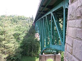 The Cut River Bridge
carries US 2 across the Cut River
in Hendricks Township
, Mackinac County. This structure was built during World War II but completion was delayed due to war-induced steel shortages. The span uses 888 ST (792.9 LT; 805.6 t) of structural steel to bridge the 641 feet (195.4 m) over the river and its gorge at a height of 147 feet (44.8 m) above the river. The Cut River Bridge is one of only two cantilevered deck truss bridges
in the state. On either side of the bridge, there are picnic areas and trails down to the river.
Listed on the NRHP on December 17, 1999, the Mackinac Trail – Carp River Bridge carries H-63
, the modern successor to US 2, over the Carp River north of St. Ignace. The bridge is another spandrel arch structure 60 feet (18.3 m) in length and built in 1920. Increasing traffic along Mackinac Trail prompted the MSHD to "widen its deck by five feet [1.5 m] and install new guardrails in the 1929–1930 biennium" along with the addition of decorative retaining walls.
The last of the historic bridges along a former segment of US 2 is the structure carrying Ashmun Street (BS I-75) over the Power Canal in Sault Ste. Marie. Built in 1934, it is one of only three steel arch bridges in the state. The 42 feet (12.8 m) and 257 feet (78.3 m) structure is described by MDOT as "massive" with an "innovative" construction method: the previous structure was used as a falsework
for the current bridge before removal.
that runs from the Wisconsin state line at the Montreal River
. The route extends through downtown Ironwood on Silver and Aurora streets before turning northward along Suffolk Street, crossing a Canadian National Railway line. On Frederick Street, BUS US 2 remains parallel to the railway and bears north through a residential area along Douglas Street. The eastern terminus of the route is at its junction with US 2 at the corner of Cloverland Drive and Douglas Street north of downtown.
The business route was created by 1945 when former M-54 in Ironwood was renumbered as a business loop of US 2. It was originally a bi-state business connection before the Wisconsin Department of Transportation
decommissioned BUS US 2 in Hurley
westward along State Trunk Highway 77
and northward along US 51
in 2002.
Everett, Washington
Everett is the county seat of and the largest city in Snohomish County, Washington, United States. Named for Everett Colby, son of founder Charles L. Colby, it lies north of Seattle. The city had a total population of 103,019 at the 2010 census, making it the 6th largest in the state and...
, to the Upper Peninsula
Upper Peninsula of Michigan
The Upper Peninsula of Michigan is the northern of the two major land masses that make up the U.S. state of Michigan. It is commonly referred to as the Upper Peninsula, the U.P., or Upper Michigan. It is also known as the land "above the Bridge" linking the two peninsulas. The peninsula is bounded...
(UP) of the US state of Michigan
Michigan
Michigan is a U.S. state located in the Great Lakes Region of the United States of America. The name Michigan is the French form of the Ojibwa word mishigamaa, meaning "large water" or "large lake"....
, with a separate segment that runs from Rouses Point, New York
Rouses Point, New York
Rouses Point is a village in Clinton County, New York, United States, along the 45th parallel. The population was 2,209 at the 2010 census. The village is named after Jacques Rouse, an early settler....
, to Houlton, Maine
Houlton, Maine
Houlton is a town in Aroostook County, Maine, on the United States – Canada border, located at . As of the 2010 census, the town population was 6,123. It is perhaps best known as being at the northern terminus of Interstate 95 and for being the birthplace of Samantha Smith...
. In Michigan, the highway runs through the UP in two segments as a part of the state trunkline highway system
Michigan Highway System
The Michigan State Trunkline Highway System is made up of all the highways designated as Interstates, U.S. Highways and State Highways in the US state of Michigan. The system is maintained by the Michigan Department of Transportation and comprises of trunklines in all 83 counties of Michigan on...
, entering the state at Ironwood
Ironwood, Michigan
Ironwood is a city in Gogebic County in the U.S. state of Michigan, about south of Lake Superior. The population was 6,293 at the 2000 census. The city is on US 2 and is situated opposite the Montreal River from Hurley, Wisconsin. It is the westernmost city in Michigan, situated on the same line...
and ending at St. Ignace
St. Ignace, Michigan
Saint Ignace, usually written as St. Ignace, is a city in the U.S. state of Michigan. As of the 2000 census, the city population was 2,678. It is the county seat of Mackinac County. From the Lower Peninsula, St. Ignace is the gateway to the Upper Peninsula.St...
; in between, US 2 briefly enters the state of Wisconsin
Wisconsin
Wisconsin is a U.S. state located in the north-central United States and is part of the Midwest. It is bordered by Minnesota to the west, Iowa to the southwest, Illinois to the south, Lake Michigan to the east, Michigan to the northeast, and Lake Superior to the north. Wisconsin's capital is...
. As one of the major transportation arteries in the UP, US 2 is a major conduit for traffic through the state and neighboring northern Midwest states. Two sections of the roadway are listed as part of the Great Lakes Circle Tours, as well as other state-designated heritage routes
Michigan Heritage Route
Michigan Heritage Route is a designation for roads in Michigan. The designation was created by the state legislature in 1993.The program emphasizes cooperation among local residents, government officials, landowners and interested groups to preserve unique scenic, historic or recreational...
. There are several memorial highway designations and historic bridges along US 2 that date to the 1910s and 1920s. As a rural highway in the UP, US 2 passes through two national and two state forests.
Before European settlers came to the UP, the route of what would become US 2 was used as part of two Indian trails, and the Michigan segments of the Theodore Roosevelt International Highway
Theodore Roosevelt International Highway
The Theodore Roosevelt International Highway was a transcontinental North American highway through the United States and Canada that ran from Portland, Maine, to Portland, Oregon. Its length was about .-Route description:...
and the King's International Highway auto trail
Auto trail
The system of auto trails was an informal network of marked routes that existed in the United States and Canada in the early part of the 20th century. Marked with colored bands on telephone poles, the trails were intended to help travellers in the early days of the automobile.Auto trails were...
s. The state later included these trails as part of M-12
M-12 (Michigan highway)
M-12 is a former state highway in the Upper Peninsula of Michigan. It was replaced in 1926 by:*U.S. Route 2 in Michigan between the state line at Ironwood and Crystal Falls*M-69 between Crystal Falls and Sagola...
when the first state highway trunklines were designated in 1919. Most of M-12 would be redesignated as part of US 2 when the US Highway System was created on November 11, 1926. Since the 1930s, several changes have reshaped the highway's routing through the UP. One such alteration eventually created a business loop that connected across the state line with Hurley, Wisconsin
Hurley, Wisconsin
Hurley is a city in and the county seat of Iron County, Wisconsin, United States. The population was 1,818 at the 2000 census. It is directly across the Montreal River from Ironwood, Michigan.-History:...
, and others pushed an originally inland routing of US 2 closer to the Lake Michigan
Lake Michigan
Lake Michigan is one of the five Great Lakes of North America and the only one located entirely within the United States. It is the second largest of the Great Lakes by volume and the third largest by surface area, after Lake Superior and Lake Huron...
shoreline. With the creation of the Interstate Highway System
Interstate Highway System
The Dwight D. Eisenhower National System of Interstate and Defense Highways, , is a network of limited-access roads including freeways, highways, and expressways forming part of the National Highway System of the United States of America...
, part of US 2 was rerouted to coincide with the new Interstate 75
Interstate 75 in Michigan
Interstate 75 is a part of the Interstate Highway System and runs from Miami, Florida to Sault Ste. Marie in the Upper Peninsula of Michigan. I-75 enters the state from Ohio in the south, just to the north of Toledo. It runs generally north through Detroit, Pontiac and Bay City, crossing the...
(I-75), though in the 1980s, the federal highway was truncated and removed from the I-75 freeway, resulting in today's basic form.
Route description
"Provid[ing] the major western gateway to Michigan", US 2 is a key highway for the state and plays "an important role in the transportation of goods across the northern tier of states in the Midwest", according to a report of a regional planning committee. The roadway is listed on the National Highway SystemNational Highway System (United States)
The National Highway System is a network of strategic highways within the United States, including the Interstate Highway System and other roads serving major airports, ports, rail or truck terminals, railway stations, pipeline terminals and other strategic transport facilities.Individual states...
(NHS) for its entire length. The NHS is a network of roadways important to the country's economy, defense, and mobility. Together with M-28, US 2 is part of a pair of primary trunklines that bridge the eastern and western sides of the UP. The 305.151 miles (491.1 km) of roadway in Michigan is divided into a 109.177 miles (175.7 km) western segment and a 195.974 miles (315.4 km) eastern segment; it is interrupted by a section of US 2 that enters the state of Wisconsin for 14.46 miles (23.3 km).
Western segment
US 2 enters Michigan from Wisconsin for the first time north of downtown Hurley, WisconsinHurley, Wisconsin
Hurley is a city in and the county seat of Iron County, Wisconsin, United States. The population was 1,818 at the 2000 census. It is directly across the Montreal River from Ironwood, Michigan.-History:...
, and Ironwood, Michigan
Ironwood, Michigan
Ironwood is a city in Gogebic County in the U.S. state of Michigan, about south of Lake Superior. The population was 6,293 at the 2000 census. The city is on US 2 and is situated opposite the Montreal River from Hurley, Wisconsin. It is the westernmost city in Michigan, situated on the same line...
, over the state line that runs along the Montreal River. The highway crosses the river into Gogebic County
Gogebic County, Michigan
-Demographics:As of the census of 2000, there were 17,370 people, 7,425 households, and 4,581 families residing in the county. The population density was 16 people per square mile . There were 10,839 housing units at an average density of 10 per square mile...
and passes a welcome center on the way into a commercial district north of downtown. Running along Cloverland Drive, US 2 meets its only business route in Michigan at Douglas Boulevard. The business route was previously a full loop that ran west through downtown Ironwood and crossed the border into Hurley and back to the main highway. The Wisconsin Department of Transportation
Wisconsin Department of Transportation
The Wisconsin Department of Transportation, abbreviated as WisDOT, is a governmental agency of the U.S. state of Wisconsin responsible for planning, building and maintaining the state's highways...
has removed the signage on their side of the border, which means that the route is currently a business spur that ends at the state line. US 2 continues eastward through the UP woodlands to the city of Bessemer
Bessemer, Michigan
Bessemer is a city in the U.S. state of Michigan. As of the 2010 census, the city population was 1,914. It is the county seat of Gogebic County....
. While bypassing the community of Ramsay, the highway crosses a branch of the Black River
Black River (Gogebic County)
The Black River is a river in the Upper Peninsula of the U.S. state of Michigan, flowing mostly in Gogebic County into Lake Superior at . Its source at is a boreal wetland on the border with Iron County, Wisconsin...
. The roadway enters Wakefield
Wakefield, Michigan
Wakefield is a city in Gogebic County in the US state of Michigan. It is located in the western Upper Peninsula. The population was 1,851 at the 2010 census....
on the south side of Sunday Lake, meeting M-28
M-28 (Michigan highway)
M-28 is an east–west state trunkline highway that almost completely traverses the Upper Peninsula in the U.S. state of Michigan, from Wakefield to near Sault Ste. Marie in Bruce Township...
at a stoplight in town. As the US Highway leaves Wakefield, it turns southeasterly through the Ottawa National Forest
Ottawa National Forest
The Ottawa National Forest is a 1.0 million acre national forest in the Upper Peninsula of the U.S. state of Michigan. It includes much of Gogebic and Ontonagon counties, as well as slices of Iron, Houghton, Baraga, and Marquette counties. The forest is under the jurisdiction of the U.S...
, crossing Jackson Creek and two branches of the Presque Isle River
Presque Isle River
The Presque Isle River runs through the Upper Peninsula of Michigan and empties into Lake Superior. Along its course, it flows through the Ottawa National Forest and Porcupine Mountains Wilderness State Park. It has 300 mi2 of drainage area in Upper Michigan and Northern Wisconsin.Several...
. US 2 and M-64
M-64 (Michigan highway)
M-64 is a north–south state trunkline highway in the Upper Peninsula of the US state of Michigan. It runs for through the western part of the state in land that is part of the Ottawa National Forest. The highway connects with County Trunk Highway B at the state line near Presque Isle, Wisconsin....
join together and run concurrently
Concurrency (road)
A concurrency, overlap, or coincidence in a road network is an instance of one physical road bearing two or more different highway, motorway, or other route numbers...
over the second branch of the Presque Isle in the community of Marenisco. This concurrency has the lowest traffic volume along the entire length of the highway within the state; in 2010 the Michigan Department of Transportation
Michigan Department of Transportation
The Michigan Department of Transportation is a constitutional government agency in the US state of Michigan. The primary purpose of MDOT is to maintain the Michigan State Trunkline Highway System which includes all Interstate, US and state highways in Michigan with the exception of the Mackinac...
(MDOT) recorded a daily average usage along the stretch of 770 vehicles. At the end of the concurrency, M-64 turns northerly to run along Lake Gogebic
Lake Gogebic
Lake Gogebic is the largest lake of the Upper Peninsula of Michigan. It is located within the 1 million acre Ottawa National Forest. Lake Gogebic State Park is located along its western shore....
.
The highway continues parallel to the state line from the Marensico area through the national forest toward Watersmeet. That unincorporated community is the home of the Watersmeet High School Nimrods, the basketball team featured on a series of ESPN
ESPN
Entertainment and Sports Programming Network, commonly known as ESPN, is an American global cable television network focusing on sports-related programming including live and pre-taped event telecasts, sports talk shows, and other original programming....
commercials and a documentary series on the Sundance Channel. The area is also where the waters meet
Drainage basin
A drainage basin is an extent or an area of land where surface water from rain and melting snow or ice converges to a single point, usually the exit of the basin, where the waters join another waterbody, such as a river, lake, reservoir, estuary, wetland, sea, or ocean...
; the rolling hills drain to Lake Superior
Lake Superior
Lake Superior is the largest of the five traditionally-demarcated Great Lakes of North America. It is bounded to the north by the Canadian province of Ontario and the U.S. state of Minnesota, and to the south by the U.S. states of Wisconsin and Michigan. It is the largest freshwater lake in the...
via the Ontonagon River
Ontonagon River
The Ontonagon River is a river flowing to Lake Superior on the western Upper Peninsula of Michigan in the United States. The main stem of the river is 25 mi long and is formed by a confluence of several longer branches, portions of which have been collectively designated as a National Wild...
, to Lake Michigan
Lake Michigan
Lake Michigan is one of the five Great Lakes of North America and the only one located entirely within the United States. It is the second largest of the Great Lakes by volume and the third largest by surface area, after Lake Superior and Lake Huron...
via the Brule
Brule River
Brule River is a river in the U.S. states of Michigan and Wisconsin, and nearly the entire course forms a portion of the boundary between the two states.The Brule begins at Brule Lake, just inside the Michigan border, at...
and Menominee
Menominee River
The Menominee River is a river in northwestern Michigan and northeastern Wisconsin in the United States. It is approximately 118 mi , draining a rural forested area of northern Wisconsin and the Upper Peninsula of Michigan into Lake Michigan...
rivers, or to the Gulf of Mexico
Gulf of Mexico
The Gulf of Mexico is a partially landlocked ocean basin largely surrounded by the North American continent and the island of Cuba. It is bounded on the northeast, north and northwest by the Gulf Coast of the United States, on the southwest and south by Mexico, and on the southeast by Cuba. In...
via the Wisconsin
Wisconsin River
-External links:* * * , Wisconsin Historical Society* * * *...
and Mississippi
Mississippi River
The Mississippi River is the largest river system in North America. Flowing entirely in the United States, this river rises in western Minnesota and meanders slowly southwards for to the Mississippi River Delta at the Gulf of Mexico. With its many tributaries, the Mississippi's watershed drains...
rivers. Also located in the area are the Sylvania Wilderness
Sylvania Wilderness
Sylvania Wilderness is an protected area located a few miles west of Watersmeet, Michigan. Sylvania is located entirely within the bounds of the Ottawa National Forest, and is currently being managed as a wilderness area as part of the National Wilderness Preservation System by the U.S. Forest...
, and the Lac Vieux Desert Indian Reservation
Lac Vieux Desert Indian Reservation
Lac Vieux Desert Indian Reservation is an Indian reservation located in Watersmeet Township of southeastern Gogebic County, in the western part of Michigan's Upper Peninsula. It is the landbase for the Lac Vieux Desert Band of Lake Superior Chippewa. The reservation has a total land area of...
which includes the Lac Vieux Desert Casino and Resort. The highway travels southeasterly from Watersmeet around the many lakes and streams in the area and crosses into rural Iron County
Iron County, Michigan
-Demographics:As of the census of 2000, there were 13,138 people, 5,748 households, and 3,615 families residing in the county. The population density was 11 people per square mile . There were 8,772 housing units at an average density of 8 per square mile...
. US 2 intersects Federal Forest Highway 16
Forest Highway 16
Federal Forest Highway 16 is a forest highway in the western Upper Peninsula of Michigan, United States. This road is erroneously marked as H-16 on the Michigan Department of Transportation map. It runs through the Ottawa National Forest and is designated by the National Forest Service...
(FFH 16) near Golden Lake in Stambaugh Township
Stambaugh Township, Michigan
Stambaugh Township is a civil township of Iron County in the U.S. state of Michigan. The population was 1,248 at the 2000 census.- Communities :* Stambaugh was a city adjacent to the township that merged into the city of Iron River effective July 1, 2000...
in the middle of the national forest. The trunkline then runs along the Iron River
Iron River (Iron County, Michigan)
The Iron River is a river in Iron County that flows from north to south through Iron River, Michigan to the Brule River....
as it approaches the city of the same name
Iron River, Michigan
Iron River is a city in Iron County in the U.S. state of Michigan. As of the 2000 census, the city population was 1,929. The U.S. Census Bureau 2006 population estimate for this city was 3,122....
and meets M-73
M-73 (Michigan highway)
M-73 is a north–south state trunkline highway in the Upper Peninsula of the US state of Michigan. It connects with US Highway 2 and Highway 55 at the state line near Iron River. Running through forest, the highway was first designated along with the rest of the state highway system in...
. In town, US 2 intersects M-189
M-189 (Michigan highway)
M-189 is a north–south state trunkline highway in the Upper Peninsula of the US state of Michigan. It serves as the continuation of Highway 139 from Wisconsin into Michigan, connecting to US Highway 2 in Iron River...
before crossing the river and turning northeast out of the city.
US 2 leaves the Ottawa National Forest at Iron River, and the highway continues eastward through forest lands near several small lakes to Crystal Falls
Crystal Falls, Michigan
-Demographics:As of the census of 2000, there were 1,791 people, 795 households, and 470 families residing in the city. The population density was 530.6 per square mile . There were 913 housing units at an average density of 270.5 per square mile...
, the county seat
County seat
A county seat is an administrative center, or seat of government, for a county or civil parish. The term is primarily used in the United States....
of Iron County. On the west side of town, US 2 meets US 141
U.S. Route 141
U.S. Route 141 is a north–south highway in the U.S. states of Michigan and Wisconsin. US 41 is its parent route. Its northern terminus, on US 41, is near Covington, Michigan; its southern terminus, with I-43 near Bellevue, Wisconsin; it remains in existence in Green Bay, Wisconsin as a...
; the two highways run concurrently along Crystal Avenue. The combined highway turns south onto 5th Street and meets M-69
M-69 (Michigan highway)
M-69 is an east–west state trunkline highway in the Upper Peninsula of the U.S. state of Michigan. It connects with US Highway 2 on both ends in Crystal Falls and near Bark River. In between, the highway runs for in rural UP forest lands.Before the creation of the U.S. Highway System, the...
's eastern terminus at the intersection between 5th Street and Superior Avenue next to the county courthouse at the top of the hill. US 2/US 141 runs south out of Crystal Falls to the west of, and parallel to, the Paint River. The roadway passes Railroad, Kennedy and Stager lakes and leaves the state of Michigan at the Brule River, crossing into Florence County, Wisconsin
Florence County, Wisconsin
Florence County is a county located in the U.S. state of Wisconsin. As of 2000, the population was 5,088. Its county seat is Florence.Florence County is part of the Iron Mountain, MI–WI Micropolitan Statistical Area.-Geography:According to the U.S...
.
Eastern segment
US 2/US 141 re-enters Michigan where it crosses the Menominee River and subsequently meets M-95M-95 (Michigan highway)
M-95, designated as the Leif Erickson Memorial Highway, is a state trunkline highway in the Upper Peninsula of the US state of Michigan. Running from Kingsford to near Champion in Humboldt Township, it is the main connection between Iron Mountain and Marquette along with US 41.M-95 was previously...
in Breitung Township
Breitung Township, Michigan
Breitung Township is a charter township of Dickinson County in the U.S. state of Michigan. As of the 2000 census, the township population was 5,930.The township is named after Edward Breitung, a miner and U.S...
north of Iron Mountain
Iron Mountain, Michigan
Iron Mountain is a city in the U.S. state of Michigan. As of the 2000 census, the city population was 8,154. It is the county seat of Dickinson County, in the state's Upper Peninsula....
and Kingsford
Kingsford, Michigan
Kingsford is a city in Dickinson County in the U.S. state of Michigan. The population was 5,549 at the 2000 census. It is part of the Iron Mountain, MI–WI Micropolitan Statistical Area....
. The highways merge together in a triple concurrency and run south on Stephenson Avenue into Iron Mountain along the west side of Lake Antoine, parallel to a branch line of the Escanaba and Lake Superior Railroad
Escanaba and Lake Superior Railroad
The Escanaba and Lake Superior Railroad is a privately held shortline railroad that operates in Northeastern Wisconsin and the Upper Peninsula of Michigan. The ELS has expanded from the original 65 miles that was purchased in 1978 to over 235 miles as of 2005....
(ELS Railroad). The road crosses through a retail corridor and over a flooded pit of the Chapin Mine. In downtown Iron Mountain at Ludington Street, M-95 turns west off Stephenson Avenue to run across town to Kingsford. US 2/US 141 exits downtown and turns east along a second retail corridor near the Midtown Mall. The highway re-enters Breitung Township where US 141 separates to the south to re-enter Wisconsin. US 2 continues eastward parallel to a branch of the Canadian National Railway
Canadian National Railway
The Canadian National Railway Company is a Canadian Class I railway headquartered in Montreal, Quebec. CN's slogan is "North America's Railroad"....
(CN Railway). Both road and rail travel through the community of Quinnesec
Quinnesec, Michigan
Quinnesec is an unincorporated community in Dickinson County in the U.S. state of Michigan. It is a census-designated place for statistical purposes and has no legally recognized status as a municipality. The population was 1,187 at the 2000 census...
, where they pass near the largest paper mill in the UP. The trunkline runs along the main street of Norway
Norway, Michigan
Norway is a city in Dickinson County in the U.S. state of Michigan. The population was 2,959 at the 2000 census. It is part of the Iron Mountain, MI–WI Micropolitan Statistical Area....
, where the highway meets the eastern terminus of US 8
U.S. Route 8
U.S. Highway 8 is a United States Highway that runs primarily east–west for , mostly within the state of Wisconsin. It runs from Interstate 35 in Forest Lake, Minnesota to US 2 at Norway in the Upper Peninsula of Michigan near the border with Wisconsin. Except for the short freeway...
. Then US 2 continues east through rural Dickinson County
Dickinson County, Michigan
-Demographics:As of the census of 2000, there were 27,472 people, 11,386 households, and 7,583 families residing in the county. The population density was 36 people per square mile . There were 13,702 housing units at an average density of 18 per square mile...
to Vulcan, passing north of Hanbury Lake through the Copper Country State Forest
Copper Country State Forest
Copper Country State Forest is a state forest in the west-central Upper Peninsula of Michigan. It is operated by the Michigan Department of Natural Resources....
, before crossing the Sturgeon River in Loretto and passing into Menominee County
Menominee County, Michigan
-Demographics:As of the census of 2000, there were 25,326 people, 10,529 households, and 7,001 families residing in the county. The population density was 24 people per square mile . There were 13,639 housing units at an average density of 13 per square mile...
.
In Menominee County, the environment takes on a more agricultural character along US 2. The highway passes through the edge of the community of Hermansville
Hermansville, Michigan
Hermansville is an unincorporated community in the Meyer Township of Menominee County in the U.S. state of Michigan. It formed as a company town based around the defunct Wisconsin Land & Lumber Company. The company's former headquarters is open as the IXL Historical Museum. U.S. Route 2 passes...
before entering Powers
Powers, Michigan
Powers is a village in Menominee County in the U.S. state of Michigan. The population was 430 at the 2000 census. It was named for John Powers, a bookkeeper for a logging company that came into the area in the late 19th century....
. US 2 comes to a three-way intersection and turns northeast merging onto US 41
U.S. Route 41 in Michigan
US Highway 41 is a part of the United States Numbered Highway System that runs from Miami, Florida, to the Upper Peninsula of the US state of Michigan. In Michigan, it is a state trunkline highway that enters the state via the Interstate Bridge between Marinette, Wisconsin, and Menominee,...
. The concurrent highway runs from Powers through the communities of Wilson
Wilson, Michigan
Wilson is an unincorporated community in Menominee County, Michigan, United States. Wilson is located in Harris Township along U.S. Route 2, U.S. Route 41 and the Canadian National Railway, east-northeast of Powers...
and Spaulding on the south side of the CN Railway. At Harris, the trunkline enters the Hannahville Indian Community
Hannahville Indian Community
The Hannahville Indian Community is a federally recognized Potawatomi Indian tribe residing in Michigan's Upper Peninsula, approximately 15 miles west of Escanaba. The reservation, at , lies mostly in eastern Menominee County, but a small section is located in adjacent southwestern Delta County...
. Harris is on the Menominee County side of the reservation, but as the highway continues east, it crosses over to Bark River
Bark River, Michigan
Bark River is an unincorporated community located in Delta County in the U.S. state of Michigan. It is located in Bark River Township near the Bark River. It is situated on U.S. Highway 2 and U.S. Highway 41 about 13 miles west of Escanaba and just east of the Hannahville Indian Reservation...
on the Delta County
Delta County, Michigan
-Demographics:As of the census of 2000, there were 38,520 people, 15,836 households, and 10,689 families residing in the county. The population density was 33 people per square mile . There were 19,223 housing units at an average density of 16 per square mile...
side. The county line in between not only separates the two communities: it serves as the boundary between the Central and Eastern
Eastern Time Zone
The Eastern Time Zone of the United States and Canada is a time zone that falls mostly along the east coast of North America. Its UTC time offset is −5 hrs during standard time and −4 hrs during daylight saving time...
time zones. East of Bark River, the highway crosses the community's namesake waterway
Bark River (Michigan)
Bark River is a river in the upper peninsula of the U.S. state of Michigan. The river is approximately 17 miles long and flows into Green Bay on Lake Michigan in Ford River Township about 15 miles southwest of Escanaba at ....
before intersecting the eastern terminus of M-69. The roadway crosses the Ford River
Ford River (Michigan)
-References:*...
prior to turning due east into the outskirts of Escanaba
Escanaba, Michigan
Escanaba is a city in the U.S. state of Michigan, located in the banana belt on the state's Upper Peninsula. As of the 2000 census, the city population was 13,140, making it the third-largest city in the Upper Peninsula after Marquette and Sault Ste. Marie...
.
US 2/US 41 widens to four lanes along Ludington Street, which forms the east–west axis of the Escanaba street grid. Near downtown, the highway meets M-35
M-35 (Michigan highway)
M-35 is a state trunkline highway in the Upper Peninsula of the US state of Michigan. Running for in a general north–south direction, it connects the cities of Menominee, Escanaba and Negaunee. The southern section of M-35 in Menominee and Delta counties carries two additional designations...
, which runs along the city's north–south axis, Lincoln Avenue. The trunklines merge together and run north, bypassing the traditional central business district for a different business corridor. Lincoln Avenue runs north carrying four lanes of traffic past the Upper Peninsula State Fair
Upper Peninsula State Fair
The Upper Peninsula State Fair is a fair held annually in the Upper Peninsula in the U.S. state of Michigan. It is held in Escanaba and is one of two official state fairs in Michigan....
grounds, site of one of the two state fair
State fair
A state fair is a competitive and recreational gathering of a U.S. state's population. It is a larger version of a county fair, often including only exhibits or competitors that have won in their categories at the more-local county fairs....
s for the state of Michigan, the only state to have twin fairs. US 2/US 41/M-35 continues north on Lincoln Avenue past the campus of Bay de Noc Community College
Bay de Noc Community College
Bay de Noc Community College is a public two-year college located in Escanaba, Michigan, United States, and was founded in 1962. The college has a main campus in Escanaba and another campus, Bay College West/Iron Mountain, in Iron Mountain, Michigan to serve Dickinson County.The college offers...
. The four-lane highway crosses the Escanaba River
Escanaba River
The Escanaba River is a river in the Upper Peninsula of the U.S. state of Michigan.In his poem The Song of Hiawatha, Henry Wadsworth Longfellow describes how Hiawatha "crossed the rushing Esconaba". It is a wide river that cuts into limestone beds...
just upstream from its mouth near the large Mead Paper Mill and shifts to run immediately next to Little Bay de Noc
Little Bay de Noc
Little Bay de Noc is a bay in the Upper Peninsula of the U.S. state of Michigan. The bay opens into Lake Michigan's Green Bay.The bay, consisting of approximately 30,000 acres , is enclosed by Delta County...
. The section here carried the highest traffic counts along all of US 2 in the state: an average of 23,977 vehicles used this segment of roadway daily in 2011.
The road turns inland again, and US 2/US 41/M-35 passes to the west of downtown Gladstone
Gladstone, Michigan
Gladstone is a city in Delta County in the U.S. state of Michigan. First settled in 1877, Gladstone's original name was Saunders Point. The population was 5,032 at the 2000 census....
. The highway through here is an expressway
Limited-access road
A limited-access road known by various terms worldwide, including limited-access highway, dual-carriageway and expressway, is a highway or arterial road for high-speed traffic which has many or most characteristics of a controlled-access highway , including limited or no access to adjacent...
, four lanes divided by a central median and no driveway access. Unlike a freeway, the expressway has standard intersections
Intersection (road)
An intersection is a road junction where two or more roads either meet or cross at grade . An intersection may be 3-way - a T junction or fork, 4-way - a crossroads, or 5-way or more...
and not interchanges
Interchange (road)
In the field of road transport, an interchange is a road junction that typically uses grade separation, and one or more ramps, to permit traffic on at least one highway to pass through the junction without directly crossing any other traffic stream. It differs from a standard intersection, at which...
. The highway intersects the eastern terminus of County Road 426 (CR 426) and crosses the ELS Railroad south of the stoplight for 4th Avenue North, where M-35 separates from the US Highways and turns to the northwest. The expressway continues north parallel to the CN Railway, crossing the Days River
Days River
The Days River is a river in the Upper Peninsula of the U.S. state of Michigan.It is a narrow river that is rocky, scenic and supports brook, steelhead trout, rainbow trout and smelt in the spring. The river runs south to its mouth on Little Bay De Noc on Lake Michigan at , near Masonville...
and running around the upper end of Little Bay de Noc before ending at Rapid River
Rapid River, Michigan
Rapid River is an unincorporated community in Masonville Township, Delta County in the U.S. state of Michigan.It is situated on the northern end of the Little Bay de Noc at , between the mouths of the Tacoosh and Rapid rivers with the mouth of the Whitefish River just to the east. U.S. Highway 2...
. In this location, US 41 separates to the north, and US 2 returns to an easterly track as a two-lane road, crossing the Rapid and Whitefish
Whitefish River (Michigan)
The Whitefish River is a river in the Upper Peninsula of the U.S. state of Michigan. The mouth of the river is in Delta County at on the Little Bay De Noc of Lake Michigan. The main branch of the river is formed by the confluence of the east and west branches at .The east branch rises out of Trout...
rivers and turning southeast around the head of the bay. As US 2 crosses southern Delta County, it passes through the western unit of the Hiawatha National Forest
Hiawatha National Forest
Hiawatha National Forest is a National Forest in the Upper Peninsula of the state of Michigan in the United States. Commercial logging is conducted in some areas. The United States Forest Service administers this National Forest; it is physically divided into two subunits, commonly called the...
. Near Garden Corners, the highway runs along the shore of Big Bay de Noc
Big Bay de Noc
Big Bay de Noc is a bay in the Upper Peninsula of the U.S. state of Michigan. The bay, which opens into Lake Michigan's Green Bay, is enclosed by Delta County...
. After the intersection with the northern terminus of M-183
M-183 (Michigan highway)
M-183 is a north–south state trunkline highway in the Upper Peninsula of the US state of Michigan. It serves Fayette State Park as an access route from US Highway 2 . The highway runs through rural farmlands of the Garden Peninsula and next to Big Bay de Noc, a bay of Lake Michigan. The community...
, US 2 turns inland cutting across the base of the Garden Peninsula
Garden Peninsula
The Garden Peninsula is a peninsula of in length that extends southwestward into Lake Michigan from the mainland of Michigan's Upper Peninsula. The peninsula is bordered by Lake Michigan on the east, and by Big Bay de Noc on the west. The base of the peninsula is served by U.S. Highway 2, and...
and enters Schoolcraft County
Schoolcraft County, Michigan
-National protected areas:* Hiawatha National Forest * Seney National Wildlife Refuge-Demographics:As of the census of 2000, there were 8,903 people, 3,606 households, and 2,498 families residing in the county. The population density was 8 people per square mile . There were 5,700 housing units...
.
As the highway approaches Thompson, US 2 leaves the western unit of the Hiawatha National Forest and enters the Lake Superior State Forest
Lake Superior State Forest
Lake Superior State Forest is a state forest in the Upper Peninsula of Michigan. It is operated by the Michigan Department of Natural Resources. The North Country Trail utilizes this state forest for 43 miles of its route....
. The roadway runs along Lake Michigan
Lake Michigan
Lake Michigan is one of the five Great Lakes of North America and the only one located entirely within the United States. It is the second largest of the Great Lakes by volume and the third largest by surface area, after Lake Superior and Lake Huron...
to Manistique
Manistique, Michigan
Manistique is a city in the Upper Peninsula of the U.S. state of Michigan. As of the 2000 census, the city population was 3,583. It is the county seat of Schoolcraft County and the only incorporated community in the county. The city lies on the north shore of Lake Michigan, at the southwest corner...
, crossing the Manistique River
Manistique River
The Manistique River is a 67-mile-long river in the U.S. state of Michigan that winds southward through the central Upper Peninsula from its headwaters near Lake Superior to its mouth in Lake Michigan. It drains approximately of the Upper Peninsula, including most of Schoolcraft County and small...
. The trunkline turns inland approaching Gulliver and then turns north-northeast to Blaney Park. The community there is a former logging town-turned-resort at the southern terminus of M-77
M-77 (Michigan highway)
M-77 is a state trunkline highway in the Upper Peninsula of the US state of Michigan. It runs from US Highway 2 near Blaney Park in the south to Grand Marais in the north. The highway borders the Seney National Wildlife Refuge. The northern half has been designated as a Scenic Spur of the Lake...
; the resort was active from the late 1920s but declined by the 1980s. From Blaney Park, US 2 turns due east and crosses into Mackinac County
Mackinac County, Michigan
-Local Airports:*Mackinac County Airport *Mackinac Island Airport -Airline service:The nearest airports with scheduled passenger service are:*Chippewa County International Airport in Sault Ste...
west of Gould City. Where it intersects a former routing, the main highway crosses the CN Railway one last time and runs to the south of Engadine to follow the Lake Michigan shoreline through Naubinway. After passing the community of Epoufette, US 2 crosses the Cut River Bridge
Cut River Bridge
Cut River Bridge is a cantilevered steel deck bridge over the Cut River in the Upper Peninsula of the U.S. state of Michigan. It is located along U.S. Highway 2 in Hendricks Township, Mackinac County, between Epoufette and Brevort, about northwest of St...
, 147 feet (44.8 m) over the Cut River
Cut River
Cut River is a small, short river in the Upper Peninsula of the U.S. state of Michigan. The 4-mile river runs along the boundary between Hendricks Township and Moran Township, with the mouth on Lake Michigan about two miles east of Epoufette and about four miles west of Brevort.It drains part of...
. The highway crosses into the eastern unit of the Hiawatha National Forest near Brevort, running between Lake Michigan and Brevort Lake in the process. The road continues along the Lake Michigan shoreline, passing Mystery Spot near Gros Cap and turning inland immediately west of St. Ignace. The US 2 designation ends at the highway's partial cloverleaf interchange with I-75
Interstate 75 in Michigan
Interstate 75 is a part of the Interstate Highway System and runs from Miami, Florida to Sault Ste. Marie in the Upper Peninsula of Michigan. I-75 enters the state from Ohio in the south, just to the north of Toledo. It runs generally north through Detroit, Pontiac and Bay City, crossing the...
. The roadway continues easterly into downtown St. Ignace as Business Loop I-75 (BL I-75).
Indian trail through auto trails
In 1701, the first transportation routes through what became the state of Michigan were the lakes, rivers and Indian trails. Two of these trails followed parts of the future US 2. The Sault – Green Bay Trail roughly followed the Lake Michigan shoreline routing of US 2 between EscanabaEscanaba, Michigan
Escanaba is a city in the U.S. state of Michigan, located in the banana belt on the state's Upper Peninsula. As of the 2000 census, the city population was 13,140, making it the third-largest city in the Upper Peninsula after Marquette and Sault Ste. Marie...
and St. Ignace
St. Ignace, Michigan
Saint Ignace, usually written as St. Ignace, is a city in the U.S. state of Michigan. As of the 2000 census, the city population was 2,678. It is the county seat of Mackinac County. From the Lower Peninsula, St. Ignace is the gateway to the Upper Peninsula.St...
. The Mackinac Trail
Mackinac Trail
Mackinac Trail, or Mackinaw Trail is the name for two related, but separate, roadways in the US state of Michigan. The original Mackinac Trail was an Indian Trail that lent its name to the roadways that replaced it. The trail ran from the modern Saginaw to Mackinaw City in the Lower Peninsula with...
connected St. Ignace with Sault Ste. Marie.
In the age of the auto trail
Auto trail
The system of auto trails was an informal network of marked routes that existed in the United States and Canada in the early part of the 20th century. Marked with colored bands on telephone poles, the trails were intended to help travellers in the early days of the automobile.Auto trails were...
, the roads that later formed US 2 through the UP were given a few different highway names. When the original roadways between Ironwood and Iron River were completed in late 1915, the Upper Peninsula Development Bureau (UPDB) named the area Cloverland and the highway the Cloverland Trail. Later the name was extended over the highway to Escanaba, and to all highways in the area in the early 1920s; the name was phased out by the UPDB completely in 1927. The roadways were also used for the Theodore Roosevelt International Highway
Theodore Roosevelt International Highway
The Theodore Roosevelt International Highway was a transcontinental North American highway through the United States and Canada that ran from Portland, Maine, to Portland, Oregon. Its length was about .-Route description:...
, named for former US president Theodore Roosevelt
Theodore Roosevelt
Theodore "Teddy" Roosevelt was the 26th President of the United States . He is noted for his exuberant personality, range of interests and achievements, and his leadership of the Progressive Movement, as well as his "cowboy" persona and robust masculinity...
after his death in 1919. Overall, this highway ran from Portland, Oregon
Portland, Oregon
Portland is a city located in the Pacific Northwest, near the confluence of the Willamette and Columbia rivers in the U.S. state of Oregon. As of the 2010 Census, it had a population of 583,776, making it the 29th most populous city in the United States...
, to Portland, Maine
Portland, Maine
Portland is the largest city in Maine and is the county seat of Cumberland County. The 2010 city population was 66,194, growing 3 percent since the census of 2000...
, by way of Michigan and the Canadian province of Ontario
Ontario
Ontario is a province of Canada, located in east-central Canada. It is Canada's most populous province and second largest in total area. It is home to the nation's most populous city, Toronto, and the nation's capital, Ottawa....
. Through the UP, the southern branch followed the immediate predecessors to US 2, including the section through Florence County, Wisconsin.
The Great Lakes Automobile Route was established in 1917 by the UPDB. A predecessor of the Great Lakes Circle Tour
Great Lakes Circle Tour
The Great Lakes Circle Tour is a designated scenic road system connecting all of the Great Lakes and the St. Lawrence River. It consists of routes for circumnavigating the lakes, either individually or collectively.-Lake Superior Circle Tour:...
s decades later, the route followed "... a circular journey along the banks of lakes Michigan and Superior and Green Bay ..." This route followed the modern US 2 from Ironwood to the M-94 junction in Manistique, using the modern M-69 and M-95 to stay in Michigan. Branches of the route followed US 41 and M-35 between Powers and Escanaba. The route was originally intended to entice motorists to drive around Lake Michigan. The name fell out of use before its first anniversary because of World War I
World War I
World War I , which was predominantly called the World War or the Great War from its occurrence until 1939, and the First World War or World War I thereafter, was a major war centred in Europe that began on 28 July 1914 and lasted until 11 November 1918...
.
One Canadian auto trail was routed through the UP as well. In 1920, the King's International Highway linked Vancouver, British Columbia, to Halifax, Nova Scotia, but there was no highway to carry it around the north side of Lake Superior. Motorists had to ship their cars by boat between Sault Ste. Marie, Ontario
Sault Ste. Marie, Ontario
Sault Ste. Marie is a city on the St. Marys River in Algoma District, Ontario, Canada. It is the third largest city in Northern Ontario, after Sudbury and Thunder Bay, with a population of 74,948. The community was founded as a French religious mission: Sault either means "jump" or "rapids" in...
, and Thunder Bay
Thunder Bay, Ontario
Thunder Bay is a city in and the seat of Thunder Bay District, Ontario, Canada. It is the most populous municipality in Northwestern Ontario, and the second most populous in Northern Ontario after Greater Sudbury...
or enter the United States to continue along the auto trail. The routings varied on the maps of the time, but its basic route used US 2 through the UP from Ironwood to Sault Ste. Marie until a highway north of Lake Superior was opened in 1960; by that time, the auto trail had taken on the Trans-Canada Highway
Trans-Canada Highway
The Trans-Canada Highway is a federal-provincial highway system that joins the ten provinces of Canada. It is, along with the Trans-Siberian Highway and Australia's Highway 1, one of the world's longest national highways, with the main route spanning 8,030 km...
name.
State trunkline
The first state trunkline highway designated along the path of the modern US 2 was M-12M-12 (Michigan highway)
M-12 is a former state highway in the Upper Peninsula of Michigan. It was replaced in 1926 by:*U.S. Route 2 in Michigan between the state line at Ironwood and Crystal Falls*M-69 between Crystal Falls and Sagola...
, a designation that was in use by July 1, 1919, between Ironwood and Sault Ste. Marie
Sault Ste. Marie, Michigan
Sault Ste. Marie is a city in and the county seat of Chippewa County in the U.S. state of Michigan. It is in the north-eastern end of Michigan's Upper Peninsula, on the Canadian border, separated from its twin city of Sault Ste. Marie, Ontario, by the St. Marys River...
. When the US Highway System was announced on November 11, 1926, US 2 partially replaced M-12. Between Crystal Falls and Iron Mountain, US 2 was routed through Florence, Wisconsin. The former routing of M-12 from Crystal Falls to Sagola became a new M-69
M-69 (Michigan highway)
M-69 is an east–west state trunkline highway in the Upper Peninsula of the U.S. state of Michigan. It connects with US Highway 2 on both ends in Crystal Falls and near Bark River. In between, the highway runs for in rural UP forest lands.Before the creation of the U.S. Highway System, the...
when the former M-69 became US 102 (now US 141). M-12 from Sagola south to Iron Mountain was made a part of an extended M-45
M-45 (Michigan highway)
M-45 is a state trunkline highway in the US state of Michigan that is also called Lake Michigan Drive. The highway runs from Agnew near Lake Michigan to the west side of Grand Rapids in the western Lower Peninsula. Lake Michigan Drive continues in each direction from M-45's termini, extending west...
, which is now M-95
M-95 (Michigan highway)
M-95, designated as the Leif Erickson Memorial Highway, is a state trunkline highway in the Upper Peninsula of the US state of Michigan. Running from Kingsford to near Champion in Humboldt Township, it is the main connection between Iron Mountain and Marquette along with US 41.M-95 was previously...
. By the next year, M-48
M-48 (Michigan highway)
M-48 is an east–west state trunkline highway in the Upper Peninsula of the US state of Michigan. It connects Rudyard with Pickford and continues to the far eastern end of the UP. The highway runs for through rural parts of Chippewa County, including along the county line with Mackinac County...
was added along US 2 from Rexton to Garnet as part of a larger extension.
The first changes to the routing of US 2 itself were made in 1930 with a bypass of downtown Escanaba. A larger rerouting was completed in 1933 between Rogers Park and Sault Ste. Marie. The new routing followed Mackinac Trail instead of turning east to Cedarville and north to Sault Ste. Marie; the former routing was given the M-121
M-121 (Michigan highway)
M-121 is a state trunkline highway in West Michigan. The highway follows Chicago Drive, a local roadway, from Zeeland to Grandville. Chicago Drive itself runs past the M-121 segment on either from Holland to Wyoming. The roadway passes through rural farmland on a route that runs parallel to...
designation. Another realignment in the Iron Mountain area shifted US 2/US 141 to a new bridge over the Menominee River
Menominee River
The Menominee River is a river in northwestern Michigan and northeastern Wisconsin in the United States. It is approximately 118 mi , draining a rural forested area of northern Wisconsin and the Upper Peninsula of Michigan into Lake Michigan...
between 1932 and 1934. Downtown Ironwood was bypassed in 1934, with the former route being initially designated M-54
M-54 (Michigan highway)
M-54 is a state trunkline highway approximately long in the US state of Michigan that bypasses the city of Flint. It is named "Dort Highway" in much of its length, in honor of Flint carriage and automobile pioneer Josiah Dallas Dort, the business partner of General Motors founder William C. Durant...
.
The Michigan State Highway Department (MSHD) changed the routings and designations of the highways around Cooks
Cooks, Michigan
Cooks is an unincorporated community in Schoolcraft County, Michigan, United States. Cooks is located in Inwood Township along the Canadian National Railway north of U.S. Route 2, west-southwest of Manistique. Cooks has a post office with ZIP code 49817....
, Thompson and Manistique
Manistique, Michigan
Manistique is a city in the Upper Peninsula of the U.S. state of Michigan. As of the 2000 census, the city population was 3,583. It is the county seat of Schoolcraft County and the only incorporated community in the county. The city lies on the north shore of Lake Michigan, at the southwest corner...
in the mid-1930s. US 2 was rerouted between Cooks and M-149
M-149 (Michigan highway)
M-149 is a north–south state trunkline highway in the Upper Peninsula of the US state of Michigan. It connects US Highway 2 in Thompson with the Palms Book and Indian Lake state parks. The highway was originally designed in the 1930s and extended a few years later...
in Thompson, with the old road turned back to county control. The section between M-149 and M-125
M-125 (Michigan highway)
M-125 Connector is a connector route running through Erie. It connects I-75 with M-125. It is a four lane divided highway for its entire length, named "Summit Street" in Erie. It is known internally to the Michigan Department of Transportation as "Connector 2"...
was redesignated as an extension of M-149 to Thompson, replacing M-125 completely. US 2 was routed along its current alignment in the area, completing the changes in 1936.
The MSHD started construction in 1936 on a new road that would take US 2 into St. Ignace for the first time. Between Brevort and Moran, US 2 previously followed Worth Road inland to the Tahquamenon Trail to meet the northern extension of US 31
U.S. Route 31 in Michigan
US Highway 31 is a part of the United States Numbered Highway System that runs from Alabama, to the Upper Peninsula of the US state of Michigan. In Michigan, it is a state trunkline highway that runs from the Indiana–Michigan state line at Bertrand Township to its terminus at Interstate 75 south...
into the Upper Peninsula. The new routing took US 2 along the lakeshore into St. Ignace. US 31 was truncated to the state ferry docks in Mackinaw City
Mackinaw City, Michigan
Mackinaw City is a village in Emmet and Cheboygan counties in the U.S. state of Michigan. At the 2000 census the population was 859. The name "Mackinaw City" is a bit of a misnomer as it is actually a village...
and US 2 was routed through St. Ignace along the former US 31 to Rogers Park; the connection in St. Ignace to the state ferry docks became M-122
M-122 (Michigan highway)
M-122 was a state trunkline highway in the US state of Michigan entirely in the city of St. Ignace. The highway connected US Highway 2 to the State Highway Ferry Dock used before the Mackinac Bridge was built. It was retired and the road returned to local control in 1957.-Route description:Prior...
. Further changes in the early 1940s straightened the roadway out near Watersmeet and Crystal Falls.
Addition realignments were completed by the MSHD to move US 2 to its modern lakeshore routing between Gould City and Epoufette in 1941. The new highway traveled due east from Gould City to Naubinway and then along the lake to Epoufette. The former route through Engadine was turned back to local control as far east as Garnet. From there east, it was numbered just M-48
M-48 (Michigan highway)
M-48 is an east–west state trunkline highway in the Upper Peninsula of the US state of Michigan. It connects Rudyard with Pickford and continues to the far eastern end of the UP. The highway runs for through rural parts of Chippewa County, including along the county line with Mackinac County...
, removing US 2 from a concurrency. Another former section into Epoufette was added to extend M-117
M-117 (Michigan highway)
M-117 is a state trunkline highway in the eastern Upper Peninsula of the US state of Michigan. The highway connects US Highway 2 with M-28 west of Newberry. The designation has been used twice in the UP, once in 1941 for a former section of US 2 between Rexton and Epoufette, and the...
. The new highway was detoured around the Cut River Bridge
Cut River Bridge
Cut River Bridge is a cantilevered steel deck bridge over the Cut River in the Upper Peninsula of the U.S. state of Michigan. It is located along U.S. Highway 2 in Hendricks Township, Mackinac County, between Epoufette and Brevort, about northwest of St...
until it was completed in 1946 after construction delays over steel shortages during World War II
World War II
World War II, or the Second World War , was a global conflict lasting from 1939 to 1945, involving most of the world's nations—including all of the great powers—eventually forming two opposing military alliances: the Allies and the Axis...
.
The western end of US 2 took on two changes in the 1940s. M-28
M-28 (Michigan highway)
M-28 is an east–west state trunkline highway that almost completely traverses the Upper Peninsula in the U.S. state of Michigan, from Wakefield to near Sault Ste. Marie in Bruce Township...
was extended along US 2 to the state line at Ironwood from its western terminus at Wakefield. A similar extension was made from M-28's eastern terminus to Sault Ste. Marie in 1948. The M-54 designation was renumbered as Business US 2 by 1945. The eastern M-28 extension was reversed in 1950, and the western extension to the state line was shifted to a new location by 1952.
Interstate era
With the coming of the Interstate Highway SystemInterstate Highway System
The Dwight D. Eisenhower National System of Interstate and Defense Highways, , is a network of limited-access roads including freeways, highways, and expressways forming part of the National Highway System of the United States of America...
in Michigan, the MSHD planned to convert the eastern section of US 2 to a freeway between St. Ignace and Sault St. Marie. In planning maps from 1947, this highway corridor was included in the system that later became the Interstates. It was also included in the General Location of National System of Interstate Highways Including All Additional Routes at Urban Areas Designated in September 1955, or Yellow Book after the cover color, that was released in 1955 as the federal government geared up plans for the freeway system. The proposed number in 1958 was Interstate 75
Interstate 75 in Michigan
Interstate 75 is a part of the Interstate Highway System and runs from Miami, Florida to Sault Ste. Marie in the Upper Peninsula of Michigan. I-75 enters the state from Ohio in the south, just to the north of Toledo. It runs generally north through Detroit, Pontiac and Bay City, crossing the...
(I-75).
The first section of freeway was built in late 1957 or early 1958 between Evergreen Shores and M-123
M-123 (Michigan highway)
M-123 is a state trunkline highway in the eastern Upper Peninsula of the U.S. state of Michigan. It is one of only a few highways in Michigan that curve around and form a U-shape. In fact, M-123 has three intersections with only two state trunklines. It meets M-28 twice as a result of its U-shaped...
north of St. Ignace. The Mackinac Bridge
Mackinac Bridge
The Mackinac Bridge is a suspension bridge spanning the Straits of Mackinac to connect the non-contiguous Upper and Lower peninsulas of the U.S. state of Michigan. Opened in 1957, the bridge is the third longest in total suspension in the world and the longest suspension bridge between anchorages...
was opened to traffic on November 1, 1957, with a new freeway interchange
Interchange (road)
In the field of road transport, an interchange is a road junction that typically uses grade separation, and one or more ramps, to permit traffic on at least one highway to pass through the junction without directly crossing any other traffic stream. It differs from a standard intersection, at which...
to connect US 2 to the bridge. This freeway interchange for the bridge was connected by a new freeway segment to the southern end of the previously completed freeway in 1961. At the time, the I-75 designation supplanted US 27 on the bridge. US 2 was shifted to the freeway and the former routing in downtown St. Ignace was redesignated BL I-75. More sections of freeway were opened in 1962 immediately to the south of the newly constructed International Bridge
Sault Ste. Marie International Bridge
The Sault Ste. Marie International Bridge, often known just as the International Bridge, spans the St. Marys River between the United States and Canada connecting the twin cities of Sault Ste. Marie, Michigan and Sault Ste. Marie, Ontario. It serves as the northern terminus of Interstate 75...
in Sault Ste. Marie as well as between Dafter and Kinross. The last two sections opened in 1963 connected the northern end of the freeway at M-123
M-123 (Michigan highway)
M-123 is a state trunkline highway in the eastern Upper Peninsula of the U.S. state of Michigan. It is one of only a few highways in Michigan that curve around and form a U-shape. In fact, M-123 has three intersections with only two state trunklines. It meets M-28 twice as a result of its U-shaped...
to Kinross, and the section between Dafter and Sault Ste. Marie. At this time, all of US 2's former routing became a county road known as Mackinac Trail (H-63)
H-63 (Michigan county highway)
H-63 is a county-designated highway in the Upper Peninsula of Michigan that follows along the Interstate 75 corridor between St. Ignace and Sault Ste. Marie. The road is known as the Mackinac Trail, named for an Indian trail used before European settlers reached the area...
.
The Department of State Highways expanded US 2/US 41 into an expressway between Gladstone
Gladstone, Michigan
Gladstone is a city in Delta County in the U.S. state of Michigan. First settled in 1877, Gladstone's original name was Saunders Point. The population was 5,032 at the 2000 census....
and Rapid River
Rapid River, Michigan
Rapid River is an unincorporated community in Masonville Township, Delta County in the U.S. state of Michigan.It is situated on the northern end of the Little Bay de Noc at , between the mouths of the Tacoosh and Rapid rivers with the mouth of the Whitefish River just to the east. U.S. Highway 2...
in 1971. The state built a new bridge over the Manistique River
Manistique River
The Manistique River is a 67-mile-long river in the U.S. state of Michigan that winds southward through the central Upper Peninsula from its headwaters near Lake Superior to its mouth in Lake Michigan. It drains approximately of the Upper Peninsula, including most of Schoolcraft County and small...
bypassing downtown in 1983. The former routing into downtown Manistique was initially an unnumbered state highway, with the remainder, including the Siphon Bridge, made an extension of M-94
M-94 (Michigan highway)
M-94 is a state trunkline in the Upper Peninsula of the US state of Michigan. It runs for from K. I. Sawyer to Manistique. The highway is part of the Lake Superior Circle Tour during a concurrency with M-28. M-94 crosses the Siphon Bridge in Manistique, unique for the fact that the bridge roadway...
. In that same year, MDOT truncated US 2 to end in St. Ignace by removing it from the I-75 freeway. The last changes were made to US 2's routing through Iron River in 1998, bypassing the bridge that formerly carried the highway over the river in town. In 2011, MDOT raised the speed limit along the expressway section in Delta County from 55 mile per hour, although the speed limit for trucks remains 55 mph (24.6 m/s).
Memorial designations and tourist routes
On July 1, 1924, the State Administrative Board named M-12, the predecessor to US 2 in Michigan, the Bohn Highway to honor Frank P. BohnFrank P. Bohn
Frank Probasco Bohn was a politician from the U.S. state of Michigan.Bohn was born in Charlottesville, Indiana, where he attended public high school...
, a prominent local citizen who later served in Congress
United States Congress
The United States Congress is the bicameral legislature of the federal government of the United States, consisting of the Senate and the House of Representatives. The Congress meets in the United States Capitol in Washington, D.C....
from 1927 to 1933. In 1929, the residents of Escanaba created a memorial to the veterans of World War I
World War I
World War I , which was predominantly called the World War or the Great War from its occurrence until 1939, and the First World War or World War I thereafter, was a major war centred in Europe that began on 28 July 1914 and lasted until 11 November 1918...
called Memory Lane. The project consisted of elm
Elm
Elms are deciduous and semi-deciduous trees comprising the genus Ulmus in the plant family Ulmaceae. The dozens of species are found in temperate and tropical-montane regions of North America and Eurasia, ranging southward into Indonesia. Elms are components of many kinds of natural forests...
and maple
Maple
Acer is a genus of trees or shrubs commonly known as maple.Maples are variously classified in a family of their own, the Aceraceae, or together with the Hippocastanaceae included in the family Sapindaceae. Modern classifications, including the Angiosperm Phylogeny Group system, favour inclusion in...
trees planted along US 2/US 41 west of town. The American Legion
American Legion
The American Legion is a mutual-aid organization of veterans of the United States armed forces chartered by the United States Congress. It was founded to benefit those veterans who served during a wartime period as defined by Congress...
sold the trees to local businesses and individuals who could honor specific soldiers. Later in 1949, the Bessemer Women's Club created a tribute in the form of a permanent living memorial to the area veterans. Also called Memory Lane, the group planted 140 elms and 1,840 evergreens, trees and shrubs as a landscaped parkway along 2.3 miles (3.7 km) of US 2 east of Bessemer.
Most of US 2, along with US 23
U.S. Route 23 in Michigan
US Highway 23 is a United States Numbered Highway that runs from Jacksonville, Florida to Mackinaw City, Michigan. In the US state of Michigan, it is a major north–south state trunkline highway that runs through the Lower Peninsula...
in the Lower Peninsula
Lower Peninsula of Michigan
The Lower Peninsula of Michigan is the southern of the two major landmasses of the U.S. state of Michigan. It is surrounded by water on all sides except its southern border, which it shares with Ohio and Indiana. Geographically, the Lower Peninsula has a recognizable shape that many people...
was designated the United Spanish War Veterans Memorial Highway in 1949. To connect the gap in the routing where US 2 cuts through Wisconsin, M-95 and M-69 were used in place of US 2 between Iron Mountain and Crystal Falls. Signs marking the highway were not erected until 1968 when Governor George W. Romney
George W. Romney
George Wilcken Romney was an American businessman and Republican Party politician. He was chairman and CEO of American Motors Corporation from 1954 to 1962, the 43rd Governor of Michigan from 1963 to 1969, and the United States Secretary of Housing and Urban Development from 1969 to 1973...
had them installed.
The Amvets Memorial Drive designation was created for the section of US 2/US 41/M-35 between the northern Escanaba city limits and County Road 426 (CR 426) in Delta County. The American Veterans
AMVETS
AMVETS or American Veterans is a volunteer-led organization formed by World War II veterans which accepts honorably discharged veterans as members....
(AMVETS) organization in Michigan petitioned the Michigan Legislature
Michigan Legislature
The Michigan Legislature is the legislative assembly of the U.S. state of Michigan. It is organized as a bicameral body consisting of the Senate, the upper house, and the House of Representatives, the lower house. Article IV of the state's Constitution, adopted in 1963, defines the role of the...
to grant this designation which was granted under Public Act 144 in 1959.
Two sections of US 2 are part of the overall Great Lakes Circle Tour
Great Lakes Circle Tour
The Great Lakes Circle Tour is a designated scenic road system connecting all of the Great Lakes and the St. Lawrence River. It consists of routes for circumnavigating the lakes, either individually or collectively.-Lake Superior Circle Tour:...
(GLCT): the segment from the Wisconsin state line near Ironwood to the M-28 junction in Wakefield is part of the Lake Superior Circle Tour (LSCT), and the segment from the southern M-35 junction in Escanaba to the eastern terminus in St. Ignace is part of the Lake Michigan Circle Tour (LMCT). These two tours were created in May 1986 through a joint effort between MDOT and its counterparts in Wisconsin, Minnesota
Minnesota
Minnesota is a U.S. state located in the Midwestern United States. The twelfth largest state of the U.S., it is the twenty-first most populous, with 5.3 million residents. Minnesota was carved out of the eastern half of the Minnesota Territory and admitted to the Union as the thirty-second state...
and Ontario. The section of US 2 between Iron River and Crystal Falls has been named the Iron County Heritage Trail. This Michigan Heritage Route
Michigan Heritage Route
Michigan Heritage Route is a designation for roads in Michigan. The designation was created by the state legislature in 1993.The program emphasizes cooperation among local residents, government officials, landowners and interested groups to preserve unique scenic, historic or recreational...
was designated to honor the "rich history of two industries that built a state and nation: mining and logging." On August 26, 2007, MDOT announced that the section of US 2 that runs concurrently with M-35 in Delta County would be included in the UP Hidden Coast Recreational Heritage Trail.
Historic bridges
There are six bridges along current or former sections of US 2 that MDOT has added to its listing of Michigan's Historic Bridges; two of these are also listed on the National Register of Historic PlacesNational Register of Historic Places
The National Register of Historic Places is the United States government's official list of districts, sites, buildings, structures, and objects deemed worthy of preservation...
(NRHP). The first is the crossing of the Iron River, which has since been bypassed by a new bridge. The original structure, dating to 1918, is a 55 feet (16.8 m) spandrel arch span that was built by the MSHD as Trunk Line Bridge No. 191. The structure was listed on the NRHP on December 9, 1999, for its architectural and engineering significance.
In 2003, MDOT replaced the Sturgeon River Bridge in Waucedah Township
Waucedah Township, Michigan
Waucedah Township is a civil township of Dickinson County in the U.S. state of Michigan. The population was 800 at the 2000 census.-Communities:*Waucedah is an unincorporated community in the township on U.S. Highway 2 at ....
, Dickinson County. , even though the old bridge was demolished and replaced, MDOT retained it on their historic bridge list. It was built in 1929.
Before 1983, US 2 used a different routing through Manistique and crossed the Manistique River on what is nicknamed the "Siphon Bridge". Built as a part of a raceway flume on the river, the water level is actually higher than the road surface. This produces a siphon
Siphon
The word siphon is sometimes used to refer to a wide variety of devices that involve the flow of liquids through tubes. But in the English language today, the word siphon usually refers to a tube in an inverted U shape which causes a liquid to flow uphill, above the surface of the reservoir,...
effect, giving the bridge its nickname. The Manistique Pulp and Paper Company was organized in 1916 and needed a dam on the Manistique River to supply their mill. This dam would require a large section of the city to be flooded, and shallow river banks meant difficulties in any bridge construction. Instead of expensive dikes, a concrete tank was built lengthwise in the river bed; the sides of this tank provided man-made banks higher than the natural banks. The Michigan Works Progress Administration
Works Progress Administration
The Works Progress Administration was the largest and most ambitious New Deal agency, employing millions of unskilled workers to carry out public works projects, including the construction of public buildings and roads, and operated large arts, drama, media, and literacy projects...
described the bridge as having "concrete bulkheads, formed by the side spans of the bridge, [that] allow the mill to maintain the water level several feet above the roadbed." The Manistique Tourism Council stated: "At one time, the bridge itself was partially supported by the water that was atmospherically forced under it," and that the bridge has been featured in Ripley's Believe It or Not!
Ripley's Believe It or Not!
Ripley's Believe It or Not! is a franchise, founded by Robert Ripley, which deals in bizarre events and items so strange and unusual that readers might question the claims...
. The eight-span structure is 294 feet (89.6 m) long.
Cut River Bridge
Cut River Bridge is a cantilevered steel deck bridge over the Cut River in the Upper Peninsula of the U.S. state of Michigan. It is located along U.S. Highway 2 in Hendricks Township, Mackinac County, between Epoufette and Brevort, about northwest of St...
carries US 2 across the Cut River
Cut River
Cut River is a small, short river in the Upper Peninsula of the U.S. state of Michigan. The 4-mile river runs along the boundary between Hendricks Township and Moran Township, with the mouth on Lake Michigan about two miles east of Epoufette and about four miles west of Brevort.It drains part of...
in Hendricks Township
Hendricks Township, Michigan
Hendricks Township is a civil township of Mackinac County in the U.S. state of Michigan. The population was 183 at the 2000 census.- Communities :...
, Mackinac County. This structure was built during World War II but completion was delayed due to war-induced steel shortages. The span uses 888 ST (792.9 LT; 805.6 t) of structural steel to bridge the 641 feet (195.4 m) over the river and its gorge at a height of 147 feet (44.8 m) above the river. The Cut River Bridge is one of only two cantilevered deck truss bridges
Cantilever bridge
A cantilever bridge is a bridge built using cantilevers, structures that project horizontally into space, supported on only one end. For small footbridges, the cantilevers may be simple beams; however, large cantilever bridges designed to handle road or rail traffic use trusses built from...
in the state. On either side of the bridge, there are picnic areas and trails down to the river.
Listed on the NRHP on December 17, 1999, the Mackinac Trail – Carp River Bridge carries H-63
H-63 (Michigan county highway)
H-63 is a county-designated highway in the Upper Peninsula of Michigan that follows along the Interstate 75 corridor between St. Ignace and Sault Ste. Marie. The road is known as the Mackinac Trail, named for an Indian trail used before European settlers reached the area...
, the modern successor to US 2, over the Carp River north of St. Ignace. The bridge is another spandrel arch structure 60 feet (18.3 m) in length and built in 1920. Increasing traffic along Mackinac Trail prompted the MSHD to "widen its deck by five feet [1.5 m] and install new guardrails in the 1929–1930 biennium" along with the addition of decorative retaining walls.
The last of the historic bridges along a former segment of US 2 is the structure carrying Ashmun Street (BS I-75) over the Power Canal in Sault Ste. Marie. Built in 1934, it is one of only three steel arch bridges in the state. The 42 feet (12.8 m) and 257 feet (78.3 m) structure is described by MDOT as "massive" with an "innovative" construction method: the previous structure was used as a falsework
Falsework
Falsework consists of temporary structures used in construction to support spanning or arched structures in order to hold the component in place until its construction is sufficiently advanced to support itself...
for the current bridge before removal.
Major intersections
The following table shows the major intersections along US 2. Included are intersections with county-designated highways and other state trunklines. MDOT has erected milemarkers along the highway that use the mileage starting at the state line in Ironwood. These markers do not reset at the state line when US 2 crosses back into Wisconsin and instead count toward total mileage.Business route
U.S. Route 2 Business Route or BUS US 2 is a 1.27 miles (2 km) business routeBusiness route
A business route in the United States and Canada is a short special route connected to a parent numbered highway at its beginning, then routed through the central business district of a nearby city or town, and finally reconnecting with the same parent numbered highway again at its...
that runs from the Wisconsin state line at the Montreal River
Montreal River (Wisconsin-Michigan)
The Montreal River is a river flowing to Lake Superior in northern Wisconsin and the Upper Peninsula of Michigan in the United States. It is approximately 40 miles long and drains approximately 270 square miles in a forested region. For most of its length, the river's course is used to define a...
. The route extends through downtown Ironwood on Silver and Aurora streets before turning northward along Suffolk Street, crossing a Canadian National Railway line. On Frederick Street, BUS US 2 remains parallel to the railway and bears north through a residential area along Douglas Street. The eastern terminus of the route is at its junction with US 2 at the corner of Cloverland Drive and Douglas Street north of downtown.
The business route was created by 1945 when former M-54 in Ironwood was renumbered as a business loop of US 2. It was originally a bi-state business connection before the Wisconsin Department of Transportation
Wisconsin Department of Transportation
The Wisconsin Department of Transportation, abbreviated as WisDOT, is a governmental agency of the U.S. state of Wisconsin responsible for planning, building and maintaining the state's highways...
decommissioned BUS US 2 in Hurley
Hurley, Wisconsin
Hurley is a city in and the county seat of Iron County, Wisconsin, United States. The population was 1,818 at the 2000 census. It is directly across the Montreal River from Ironwood, Michigan.-History:...
westward along State Trunk Highway 77
Highway 77 (Wisconsin)
State Trunk Highway 77 is a state highway in the U.S. state of Wisconsin. It runs east–west in northwest Wisconsin from the Michigan border in Hurley to the Minnesota border near Danbury....
and northward along US 51
U.S. Route 51 in Wisconsin
In the U.S. state of Wisconsin, U.S. Route 51 runs north–south down the central part of the state...
in 2002.