

U.S. Route 191 in Utah
Encyclopedia
U.S. Route 191
is a major north–south state highway
through the eastern part of the U.S. state
of Utah
. The present alignment of US-191, which stretches from Mexico
to Canada
, was created in 1981 through Utah. Previously the route had entered northern Utah, ending at US-91 in Brigham City, but with the completion of I-15 it was truncated to Yellowstone National Park
and re-extended on a completely different alignment. In addition to a large portion of US-163, this extension absorbed several state routes: SR-33, most of SR-44, and SR-260.
 US-191 enters Utah on Navajo Nation
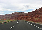
land and crosses mostly desolate parts of the state. The largest cities served by US-191 are Moab
, Price
and Vernal
. The highway nears the 10000 feet (3,048 m) level in 2 places in Utah, over Indian Summit near Price and again while crossing the Uintah Mountains near Vernal. It leaves Utah at Flaming Gorge Reservoir
. US-191 directly or indirectly serves a number of parks in eastern Utah: Monument Valley Navajo Tribal Park, Glen Canyon National Recreation Area
, Hovenweep National Monument
, Natural Bridges National Monument
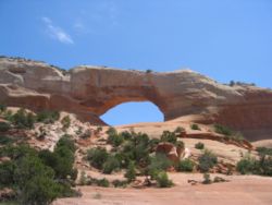
, Capitol Reef National Park
, Canyonlands National Park
, Arches National Park
, Dead Horse Point State Park
, Dinosaur National Monument
, and Flaming Gorge National Recreation Area
.
 Three portions of US-191 in Utah have been designated National Scenic Byway
s. Between U.S. Route 163 and State Route 95, US-191 forms part of the Trail of the Ancients
. From Moab
to Vernal
, US-191 is a portion of the Dinosaur Diamond Prehistoric Highway. The Flaming Gorge-Uintas Scenic Byway
begins at Vernal and follows US-191 to Flaming Gorge
. The state has designated the portion from Helper
to Duchesne
as the Indian Canyon Scenic Byway, a Utah Scenic Byway.
 Three portions of US-191 in Utah have restrictions on truck
s and other large vehicles. Between the junctions with State Routes 46
and 279
, vehicles wider than 15 feet (4.57 m) are required to have two police escorts. Between Vernal and the Wyoming State line, vehicles longer than 95 feet (29 m) are required to have two certified pilot escorts. Vehicles heavier than 20000 pounds (9,071.8 kg) per axle
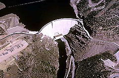
are prohibited on Flaming Gorge Dam
.
. An extension in the late 1930s brought US-191 south to Brigham City, Utah
, following what was then SR-41 and is now mostly SR-13. With the construction of I-15 parallel to US-191, the latter route was removed from Utah in the early 1970s, and by 1980 it only existed north of Yellowstone.
In cooperation with Montana
, Wyoming
, and Arizona
, the Utah Department of Transportation
submitted an application to the American Association of State Highway and Transportation Officials
(AASHTO) for an extension of US-191. In Wyoming, it would replace US 187 - a single-state route, which was against current AASHTO policy — and then follow Wyoming Highway 373 to the state line. The portion in Utah replaced several state routes — State Route 260 from Wyoming to Greendale Junction, the majority of SR-44 to US-40 in Vernal, and SR-33 from US-40 in Duchesne to US-6 near Price. After overlapping US-6 past Green River, the routing followed and replaced a large portion of US-163 to a junction southwest of Bluff. Between Bluff and Mexican Water, Arizona
, US-191 followed a newly-constructed road across the Navajo Indian Reservation, and then replaced State Route 63, still mostly inside the reservation, to I-40 at Chambers
. (It has since been continued along former US 666 to Douglas on the Mexican border.)
was added in 1912, as was a connection from Thompson to via Cisco
to Colorado. An extension from Monticello southeast to Colorado was added in 1913, and in the 1920s most of these roadways were assigned numbers: State Route 8 went from Green River via Floy, Valley City, Thompson, and Cisco to Colorado, and State Route 9 began at Valley City and extended south via Moab to Monticello and east to Colorado.
 With the creation of the U.S. Highway system in 1926, SR-8 and SR-9 each received a second designation, US-50 and U.S. Route 450 respectively. The state legislature redefined all the state routes in 1927, and moved SR-8 to a direct Floy-Thompson cutoff, with both roads from Valley City to Floy and Thompson becoming SR-9. The Monticello-Bluff road was assigned State Route 47 and extended to Mexican Hat at that time and to the Arizona
state line in 1931. The State Road Commission designated a new alignment of SR-9 to Crescent Junction
on SR-8 in 1934, replacing both branches to Floy and Thompsons, and the legislature updated the description in 1935; at that time, US-450 was extended from Valley City to Crescent Junction on the new SR-8 (US-50) cutoff.
Although no significant changes were made to SR-9 or SR-47 after 1935, the signed U.S. Highway numbers changed several times. First, in the late 1930s, U.S. Route 160
replaced US-450, continuing to enter the state east of Monticello and end at Crescent Junction. Then in about 1970, US-163 was designated along the entire length of SR-47 from Arizona to Monticello, and replaced US-160 north to Crescent Junction; at the same time, US-666 was extended from Cortez, Colorado
over US-160 to a new terminus at US-163 in Monticello. The 1977 renumbering saw the elimination of SR-9 and SR-47, by then no longer signed due to the concurrent U.S. Highway designations. The final change (except for the 2003 renumbering of US-666 to US-491) came in 1981, when US-191 replaced US-163 north of a junction near Bluff. South of this intersection, US-191 followed a route that not formerly existed as a state highway. The Bureau of Indian Affairs
(BIA) completed this road across the Navajo Indian Reservation, and San Juan County built the short piece north of the San Juan River, in time for the extension of US-191. After the BIA granted an easement
to Utah for the road, formerly BIA Route N12 (23) 2&3, in 1988, it was added to the state highway system the next year.
 The road connecting Colton
on SR-8 (US-50, now US-6) with SR-6 (US-40) in Duchesne became a state highway in 1910. The southwest end was moved from Colton to Castle Gate
in 1912, and in 1927 it was numbered State Route 33. Few changes were made to the roadway, and in 1981 it became part of US-191.
, was added to the state highway system in about 1918 as a forest highway
project, completed in 1926, and numbered SR-44 in 1927. It was the only state road connecting Daggett County's seat, Manila, with the rest of the state, yet parts remained in an unimproved condition through the 1950s.
Several routes have been designated over the years to connect SR-44 to Flaming Gorge
, a canyon
on the Green River
that lends its name to the Flaming Gorge Dam
that US-191 now crosses the river on. The first was State Route 165, which would have begun at SR-44 south of Manila and headed east to the gorge. The state legislature added the proposed road to the state highway system in 1933, but in 1935 it was deleted, and the number was reused to the west on a portion of Birch Creek Road. Later, in 1941, the planned connection was redesignated as a state highway, this time State Route 220, but in 1945 it was moved north, closer to the state line.
It was this alignment that was actually built, beginning at Linwood
on SR-43 and proceeding east-southeasterly through a valley that is now flooded by the Flaming Gorge Reservoir
's Linwood Bay. SR-220 was deleted in 1957, but in its place was a new State Route 260 that began at Greendale Junction on SR-44 and headed northeast over the dam (then under construction) and to the state line. The legislature did not specify where it would intersect the border, and the State Road Commission initially routed it along former SR-220 to Linwood. However, the law was amended in 1963 to define the north end to be east of the reservoir, and soon the lake began to fill, cutting off the road to Linwood (and inundating that settlement). By 1981 the new road was completed, and most of SR-44 and all of SR-260 were absorbed by US-191.
U.S. Route 191
U.S. Route 191 is a spur of U.S. Route 91 that has two branches. The southern branch runs for 1,465 miles from Douglas, Arizona on the Mexican border to the southern part of Yellowstone National Park. The northern branch runs for 440 miles from the northern part of Yellowstone National Park to...
is a major north–south state highway
State highway
State highway, state road or state route can refer to one of three related concepts, two of them related to a state or provincial government in a country that is divided into states or provinces :#A...
through the eastern part of the U.S. state
U.S. state
A U.S. state is any one of the 50 federated states of the United States of America that share sovereignty with the federal government. Because of this shared sovereignty, an American is a citizen both of the federal entity and of his or her state of domicile. Four states use the official title of...
of Utah
Utah
Utah is a state in the Western United States. It was the 45th state to join the Union, on January 4, 1896. Approximately 80% of Utah's 2,763,885 people live along the Wasatch Front, centering on Salt Lake City. This leaves vast expanses of the state nearly uninhabited, making the population the...
. The present alignment of US-191, which stretches from Mexico
Mexico
The United Mexican States , commonly known as Mexico , is a federal constitutional republic in North America. It is bordered on the north by the United States; on the south and west by the Pacific Ocean; on the southeast by Guatemala, Belize, and the Caribbean Sea; and on the east by the Gulf of...
to Canada
Canada
Canada is a North American country consisting of ten provinces and three territories. Located in the northern part of the continent, it extends from the Atlantic Ocean in the east to the Pacific Ocean in the west, and northward into the Arctic Ocean...
, was created in 1981 through Utah. Previously the route had entered northern Utah, ending at US-91 in Brigham City, but with the completion of I-15 it was truncated to Yellowstone National Park
Yellowstone National Park
Yellowstone National Park, established by the U.S. Congress and signed into law by President Ulysses S. Grant on March 1, 1872, is a national park located primarily in the U.S. state of Wyoming, although it also extends into Montana and Idaho...
and re-extended on a completely different alignment. In addition to a large portion of US-163, this extension absorbed several state routes: SR-33, most of SR-44, and SR-260.
Route description
Navajo Nation
The Navajo Nation is a semi-autonomous Native American-governed territory covering , occupying all of northeastern Arizona, the southeastern portion of Utah, and northwestern New Mexico...
land and crosses mostly desolate parts of the state. The largest cities served by US-191 are Moab
Moab, Utah
Moab is a city in Grand County, in eastern Utah, in the western United States. The population was 4,779 at the 2000 census. It is the county seat and largest city in Grand County. Moab hosts a large number of tourists every year, mostly visitors to the nearby Arches and Canyonlands National Parks...
, Price
Price, Utah
Price is a city in Carbon County, Utah, United States. The city is home to the USU-College of Eastern Utah, as well as the large USU Eastern Prehistoric Museum affiliated with the college. Price is located within short distances from both Nine Mile Canyon and the Manti-La Sal National Forest...
and Vernal
Vernal, Utah
Vernal, Uintah County's largest city, is located in eastern Utah near the Colorado State Line, and 175 miles east of Salt Lake City. It is bordered on the north by the Uinta Mountains, one of the few mountains ranges in the world which lie in an east-west rather than the usual north to south...
. The highway nears the 10000 feet (3,048 m) level in 2 places in Utah, over Indian Summit near Price and again while crossing the Uintah Mountains near Vernal. It leaves Utah at Flaming Gorge Reservoir
Flaming Gorge Reservoir
Flaming Gorge Reservoir is a reservoir in Wyoming and Utah, on the Green River, created by Flaming Gorge Dam. Construction on the dam began in 1958 and was completed in 1964...
. US-191 directly or indirectly serves a number of parks in eastern Utah: Monument Valley Navajo Tribal Park, Glen Canyon National Recreation Area
Glen Canyon National Recreation Area
Glen Canyon National Recreation Area is a recreation and conservation unit of the National Park Service that encompasses the area around Lake Powell and lower Cataract Canyon in Utah and Arizona, covering 1,254,429 acres of mostly desert...
, Hovenweep National Monument
Hovenweep National Monument
Hovenweep National Monument is located on land in southwestern Colorado and southeastern Utah, located between Cortez, Colorado and Blanding, Utah on the Cajon Mesa of the Great Sage Plain...
, Natural Bridges National Monument
Natural Bridges National Monument
Natural Bridges National Monument is a U.S. National Monument located about north west of the Four Corners boundary of southeast Utah, in the western United States, at the junction of White Canyon and Armstrong Canyon, part of the Colorado River drainage...
, Capitol Reef National Park
Capitol Reef National Park
Capitol Reef National Park is a United States National Park, in south-central Utah. It is 100 miles long but fairly narrow. The park, established in 1971, preserves 378 mi² and is open all year, although May through September are the most popular months.Called "Wayne Wonderland" in the 1920s...
, Canyonlands National Park
Canyonlands National Park
Canyonlands National Park is a U.S. National Park located in southeastern Utah near the town of Moab and preserves a colorful landscape eroded into countless canyons, mesas and buttes by the Colorado River, the Green River, and their respective tributaries. The park is divided into four districts:...
, Arches National Park
Arches National Park
Arches National Park is a U.S. National Park in eastern Utah. It is known for preserving over 2000 natural sandstone arches, including the world-famous Delicate Arch, in addition to a variety of unique geological resources and formations....
, Dead Horse Point State Park
Dead Horse Point State Park
Dead Horse Point State Park is a state park of Utah, USA, featuring a dramatic overlook of the Colorado River and Canyonlands National Park. The park is so named because of its use as a natural corral by cowboys in the 19th century...
, Dinosaur National Monument
Dinosaur National Monument
Dinosaur National Monument is a National Monument located on the southeast flank of the Uinta Mountains on the border between Colorado and Utah at the confluence of the Green and Yampa Rivers. Although most of the monument area is in Moffat County, Colorado, the Dinosaur Quarry is located in Utah...
, and Flaming Gorge National Recreation Area
Flaming Gorge National Recreation Area
Flaming Gorge National Recreation Area is a United States National Recreation Area located in the states of Wyoming and Utah. The centerpiece of the recreation area is the 91 mile long Flaming Gorge Reservoir, a reservoir created by the Flaming Gorge Dam along the Green River in 1964...
.
National Scenic Byway
A National Scenic Byway is a road recognized by the United States Department of Transportation for its archeological, cultural, historic, natural, recreational, and/or scenic qualities. The program was established by Congress in 1991 to preserve and protect the nation's scenic but often...
s. Between U.S. Route 163 and State Route 95, US-191 forms part of the Trail of the Ancients
Trail of the Ancients
The Trail of the Ancients is an National Scenic Byway located in the states of Colorado and Utah. The route highlights the archaeological and cultural history of southwestern Native American peoples, and traverses the widely diverse geological landscape of the Four Corners region...
. From Moab
Moab, Utah
Moab is a city in Grand County, in eastern Utah, in the western United States. The population was 4,779 at the 2000 census. It is the county seat and largest city in Grand County. Moab hosts a large number of tourists every year, mostly visitors to the nearby Arches and Canyonlands National Parks...
to Vernal
Vernal, Utah
Vernal, Uintah County's largest city, is located in eastern Utah near the Colorado State Line, and 175 miles east of Salt Lake City. It is bordered on the north by the Uinta Mountains, one of the few mountains ranges in the world which lie in an east-west rather than the usual north to south...
, US-191 is a portion of the Dinosaur Diamond Prehistoric Highway. The Flaming Gorge-Uintas Scenic Byway
Flaming Gorge-Uintas Scenic Byway
The Flaming Gorge - Uintas Scenic Byway is a National Scenic Byway in the state of Utah. It spans approximately as it travels from Vernal, Utah northward through the Ashley National Forest and the Uintah Mountains to the area around Flaming Gorge National Recreation Area in the northeastern corner...
begins at Vernal and follows US-191 to Flaming Gorge
Flaming Gorge National Recreation Area
Flaming Gorge National Recreation Area is a United States National Recreation Area located in the states of Wyoming and Utah. The centerpiece of the recreation area is the 91 mile long Flaming Gorge Reservoir, a reservoir created by the Flaming Gorge Dam along the Green River in 1964...
. The state has designated the portion from Helper
Helper, Utah
Helper is a city in Carbon County, Utah, United States about 120 miles southeast of Salt Lake City and northwest of the city of Price. It is also known as the "Hub of Carbon County". The population was 2,025 at the 2000 census....
to Duchesne
Duchesne, Utah
Duchesne is a city in and the county seat of Duchesne County, Utah, United States. The population was 1,690 at the 2010 census.-Geography:Duchesne city is located at . just west of the junction of the Strawberry and Duchesne rivers in the Uintah Basin of northeastern Utah...
as the Indian Canyon Scenic Byway, a Utah Scenic Byway.
Truck
A truck or lorry is a motor vehicle designed to transport cargo. Trucks vary greatly in size, power, and configuration, with the smallest being mechanically similar to an automobile...
s and other large vehicles. Between the junctions with State Routes 46
Utah State Route 46
State Route 46 is a state highway at the eastern edge of Utah running for in San Juan County.-Route description:The route begins in the west at its junction with US-191 at La Sal Junction about twenty miles south of Moab and proceeds eastward to the south of the La Sal Mountains through the town...
and 279
Utah State Route 279
State Route 279 is a state highway in the U.S. state of Utah. The highway was constructed in 1962–1963 to service the Cane Creek potash mine and processing plant southwest of Moab. The highway was named one of the most beautiful highways opened to traffic in 1963...
, vehicles wider than 15 feet (4.57 m) are required to have two police escorts. Between Vernal and the Wyoming State line, vehicles longer than 95 feet (29 m) are required to have two certified pilot escorts. Vehicles heavier than 20000 pounds (9,071.8 kg) per axle
Axle
An axle is a central shaft for a rotating wheel or gear. On wheeled vehicles, the axle may be fixed to the wheels, rotating with them, or fixed to its surroundings, with the wheels rotating around the axle. In the former case, bearings or bushings are provided at the mounting points where the axle...
are prohibited on Flaming Gorge Dam
Flaming Gorge Dam
The Flaming Gorge Dam is a concrete thin-arch dam in the Flaming Gorge of the Green River, a major tributary of the Colorado River, in the U.S. state of Utah. One of the largest dams in the American West, Flaming Gorge Dam forms the Flaming Gorge Reservoir, which extends into southern Wyoming,...
.
History
When US-191 was created in 1926, it did not enter Utah, only running from Idaho Falls northeast to Yellowstone National ParkYellowstone National Park
Yellowstone National Park, established by the U.S. Congress and signed into law by President Ulysses S. Grant on March 1, 1872, is a national park located primarily in the U.S. state of Wyoming, although it also extends into Montana and Idaho...
. An extension in the late 1930s brought US-191 south to Brigham City, Utah
Brigham City, Utah
Brigham City is a city in Box Elder County, Utah, United States. The population was 17,899 at the 2010 census. It is the county seat of Box Elder County. It lies on the western slope of the Wellsville Mountains, a branch of the Wasatch Range at the western terminus of Box Elder Canyon...
, following what was then SR-41 and is now mostly SR-13. With the construction of I-15 parallel to US-191, the latter route was removed from Utah in the early 1970s, and by 1980 it only existed north of Yellowstone.
In cooperation with Montana
Montana
Montana is a state in the Western United States. The western third of Montana contains numerous mountain ranges. Smaller, "island ranges" are found in the central third of the state, for a total of 77 named ranges of the Rocky Mountains. This geographical fact is reflected in the state's name,...
, Wyoming
Wyoming
Wyoming is a state in the mountain region of the Western United States. The western two thirds of the state is covered mostly with the mountain ranges and rangelands in the foothills of the Eastern Rocky Mountains, while the eastern third of the state is high elevation prairie known as the High...
, and Arizona
Arizona
Arizona ; is a state located in the southwestern region of the United States. It is also part of the western United States and the mountain west. The capital and largest city is Phoenix...
, the Utah Department of Transportation
Utah Department of Transportation
The Utah Department of Transportation is an agency of the state government for the U.S. state of Utah. The agency is usually referred to by its initials UDOT . UDOT is charged with maintaining the network of state highways in Utah. The agency is headquartered in the Calvin L. Rampton state office...
submitted an application to the American Association of State Highway and Transportation Officials
American Association of State Highway and Transportation Officials
AASHTO, the American Association of State Highway and Transportation Officials, is a standards setting body which publishes specifications, test protocols and guidelines which are used in highway design and construction throughout the United States...
(AASHTO) for an extension of US-191. In Wyoming, it would replace US 187 - a single-state route, which was against current AASHTO policy — and then follow Wyoming Highway 373 to the state line. The portion in Utah replaced several state routes — State Route 260 from Wyoming to Greendale Junction, the majority of SR-44 to US-40 in Vernal, and SR-33 from US-40 in Duchesne to US-6 near Price. After overlapping US-6 past Green River, the routing followed and replaced a large portion of US-163 to a junction southwest of Bluff. Between Bluff and Mexican Water, Arizona
Mexican Water, Arizona
Mexican Water is an unincorporated community in Apache County, Arizona, United States. Mexican Water is located on the Navajo Nation west of Red Mesa....
, US-191 followed a newly-constructed road across the Navajo Indian Reservation, and then replaced State Route 63, still mostly inside the reservation, to I-40 at Chambers
Chambers, Arizona
Chambers is an unincorporated community in Apache County, Arizona, United States. Chambers is located at the junction of Interstate 40 and U.S. Route 191 northeast of Holbrook. Chambers has a post office with ZIP code 86502....
. (It has since been continued along former US 666 to Douglas on the Mexican border.)
Arizona to US-6
The road from Bluff north via Monticello, Moab, and Valley City to Thompson (a station on the Denver and Rio Grande Railroad) became a state highway in 1910. To connect this road with the rest of the state highway system, a road from Valley City northwest via Floy to Green RiverGreen River, Utah
Green River is a city in Emery County, Utah, United States. The population was 973 at the 2000 census.-Geography:Green River is located at , on the banks of the Green River, after which the city is named. The San Rafael Swell region is to the west of Green River, while Canyonlands National Park...
was added in 1912, as was a connection from Thompson to via Cisco
Cisco, Utah
Cisco is a ghost town in Grand County, Utah near the junction of State Route 128 and Interstate 70. At one time the town served as a saloon and water-refilling station for the Denver and Rio Grande Western Railroad. The town's demise came with the demise of the steam locomotive. The town site...
to Colorado. An extension from Monticello southeast to Colorado was added in 1913, and in the 1920s most of these roadways were assigned numbers: State Route 8 went from Green River via Floy, Valley City, Thompson, and Cisco to Colorado, and State Route 9 began at Valley City and extended south via Moab to Monticello and east to Colorado.
Arizona
Arizona ; is a state located in the southwestern region of the United States. It is also part of the western United States and the mountain west. The capital and largest city is Phoenix...
state line in 1931. The State Road Commission designated a new alignment of SR-9 to Crescent Junction
Crescent Junction, Utah
Crescent Junction is a small unincorporated community within Grand County in the eastern part of the U.S. state of Utah. The community is located at above sea level. Most highway maps use the name Crescent Junction, as the name given to the junction of Interstate 70 and U.S. Route 191...
on SR-8 in 1934, replacing both branches to Floy and Thompsons, and the legislature updated the description in 1935; at that time, US-450 was extended from Valley City to Crescent Junction on the new SR-8 (US-50) cutoff.
Although no significant changes were made to SR-9 or SR-47 after 1935, the signed U.S. Highway numbers changed several times. First, in the late 1930s, U.S. Route 160
U.S. Route 160
U.S. Route 160 is a 1,465 mile long east–west United States highway in the Midwestern United States. The western terminus of the route is at U.S. Route 89 five miles west of Tuba City, Arizona. The eastern terminus is at U.S...
replaced US-450, continuing to enter the state east of Monticello and end at Crescent Junction. Then in about 1970, US-163 was designated along the entire length of SR-47 from Arizona to Monticello, and replaced US-160 north to Crescent Junction; at the same time, US-666 was extended from Cortez, Colorado
Cortez, Colorado
The city of Cortez is a Home Rule Municipality that is the county seat and the most populous city of Montezuma County, Colorado, United States. The city population was 8,482 at the 2010 census...
over US-160 to a new terminus at US-163 in Monticello. The 1977 renumbering saw the elimination of SR-9 and SR-47, by then no longer signed due to the concurrent U.S. Highway designations. The final change (except for the 2003 renumbering of US-666 to US-491) came in 1981, when US-191 replaced US-163 north of a junction near Bluff. South of this intersection, US-191 followed a route that not formerly existed as a state highway. The Bureau of Indian Affairs
Bureau of Indian Affairs
The Bureau of Indian Affairs is an agency of the federal government of the United States within the US Department of the Interior. It is responsible for the administration and management of of land held in trust by the United States for Native Americans in the United States, Native American...
(BIA) completed this road across the Navajo Indian Reservation, and San Juan County built the short piece north of the San Juan River, in time for the extension of US-191. After the BIA granted an easement
Easement
An easement is a certain right to use the real property of another without possessing it.Easements are helpful for providing pathways across two or more pieces of property or allowing an individual to fish in a privately owned pond...
to Utah for the road, formerly BIA Route N12 (23) 2&3, in 1988, it was added to the state highway system the next year.
US-6 to US-40
Colton, Utah
-External links:* at GhostTowns.com* at Legends of America...
on SR-8 (US-50, now US-6) with SR-6 (US-40) in Duchesne became a state highway in 1910. The southwest end was moved from Colton to Castle Gate
Castle Gate, Utah
Castle Gate is a ghost town located in Carbon County in eastern Utah, USA. Castle Gate was a mining town approximately southeast of Salt Lake City, Utah. The name of the town was derived from a rock formation near the mouth of Price Canyon...
in 1912, and in 1927 it was numbered State Route 33. Few changes were made to the roadway, and in 1981 it became part of US-191.
US-40 to Wyoming
The road from SR-6 (US-40) in Vernal north to SR-43 in Manila, where one could continue to WyomingWyoming
Wyoming is a state in the mountain region of the Western United States. The western two thirds of the state is covered mostly with the mountain ranges and rangelands in the foothills of the Eastern Rocky Mountains, while the eastern third of the state is high elevation prairie known as the High...
, was added to the state highway system in about 1918 as a forest highway
Forest Highway
Forest Highways or Forest Routes are a category of roads within United States National Forests. They are built to connect the national forests to the existing state highway systems, and to provide improved access to recreational and logging areas....
project, completed in 1926, and numbered SR-44 in 1927. It was the only state road connecting Daggett County's seat, Manila, with the rest of the state, yet parts remained in an unimproved condition through the 1950s.
Several routes have been designated over the years to connect SR-44 to Flaming Gorge
Flaming Gorge Reservoir
Flaming Gorge Reservoir is a reservoir in Wyoming and Utah, on the Green River, created by Flaming Gorge Dam. Construction on the dam began in 1958 and was completed in 1964...
, a canyon
Canyon
A canyon or gorge is a deep ravine between cliffs often carved from the landscape by a river. Rivers have a natural tendency to reach a baseline elevation, which is the same elevation as the body of water it will eventually drain into. This forms a canyon. Most canyons were formed by a process of...
on the Green River
Green River (Utah)
The Green River, located in the western United States, is the chief tributary of the Colorado River. The watershed of the river, known as the Green River Basin, covers parts of Wyoming, Utah, and Colorado. The Green River is long, beginning in the Wind River Mountains of Wyoming and flowing...
that lends its name to the Flaming Gorge Dam
Flaming Gorge Dam
The Flaming Gorge Dam is a concrete thin-arch dam in the Flaming Gorge of the Green River, a major tributary of the Colorado River, in the U.S. state of Utah. One of the largest dams in the American West, Flaming Gorge Dam forms the Flaming Gorge Reservoir, which extends into southern Wyoming,...
that US-191 now crosses the river on. The first was State Route 165, which would have begun at SR-44 south of Manila and headed east to the gorge. The state legislature added the proposed road to the state highway system in 1933, but in 1935 it was deleted, and the number was reused to the west on a portion of Birch Creek Road. Later, in 1941, the planned connection was redesignated as a state highway, this time State Route 220, but in 1945 it was moved north, closer to the state line.
It was this alignment that was actually built, beginning at Linwood
Linwood, Utah
Linwood was a small, unincorporated village in north-central Daggett County, Utah, USA, near the Wyoming state line. The town, located along Henrys Fork of the Green River about 5 miles east of the county seat of Manila, was first settled in the 1890s...
on SR-43 and proceeding east-southeasterly through a valley that is now flooded by the Flaming Gorge Reservoir
Flaming Gorge Reservoir
Flaming Gorge Reservoir is a reservoir in Wyoming and Utah, on the Green River, created by Flaming Gorge Dam. Construction on the dam began in 1958 and was completed in 1964...
's Linwood Bay. SR-220 was deleted in 1957, but in its place was a new State Route 260 that began at Greendale Junction on SR-44 and headed northeast over the dam (then under construction) and to the state line. The legislature did not specify where it would intersect the border, and the State Road Commission initially routed it along former SR-220 to Linwood. However, the law was amended in 1963 to define the north end to be east of the reservoir, and soon the lake began to fill, cutting off the road to Linwood (and inundating that settlement). By 1981 the new road was completed, and most of SR-44 and all of SR-260 were absorbed by US-191.
Major intersections
| County | Location | Mile | # Exit number An exit number is a number assigned to a road junction, usually an exit from a freeway. It is usually marked on the same sign as the destinations of the exit, as well as a sign in the gore.... |
Destinations | Notes |
|---|---|---|---|---|---|
| San Juan County | 0.00 | Arizona state line | |||
| 21.229 | , Monument Valley Monument Valley Monument Valley is a region of the Colorado Plateau characterized by a cluster of vast sandstone buttes, the largest reaching above the valley floor. It is located on the northern border of Arizona with southern Utah , near the Four Corners area... |
||||
| Bluff | 25.996 | ||||
| 36.438 | |||||
| 47.255 | |||||
| Monticello | 71.857 | ||||
| 86.136 | |||||
| La Sal Junction | 103.446 | ||||
| Grand | 128.180 | ||||
| 129.798 | |||||
| 136.733 | |||||
| Crescent Junction Crescent Junction, Utah Crescent Junction is a small unincorporated community within Grand County in the eastern part of the U.S. state of Utah. The community is located at above sea level. Most highway maps use the name Crescent Junction, as the name given to the junction of Interstate 70 and U.S. Route 191... |
157.193 | – Grand Junction | Interchange; south end of I-70/US-6/US-50 overlap | ||
| 175 | Ranch Exit | Interchange | |||
| 164 | Interchange | ||||
| Emery | 160 | Interchange | |||
| Interchange; north end of I-70/US-50 overlap | |||||
| Carbon | Sunnyside Junction | ||||
| Wellington | Nine Mile Canyon Nine Mile Canyon Nine Mile Canyon is a canyon, approximately long, located in the counties of Carbon and Duchesne in eastern Utah, in the Western United States. Promoted as "the world’s longest art gallery," the canyon is known for its extensive rock art, most of it created by the Fremont culture and the Ute people... Road |
Former SR-53 | |||
| Price | 243 | Interchange | |||
| 241 | Interchange | ||||
| 240 | Interchange | ||||
| Helper | |||||
| 251.434 | North end of US-6 overlap | ||||
| Duchesne | Duchesne | 294.847 | South end of US-40 overlap | ||
| Myton | Nine Mile Canyon Nine Mile Canyon Nine Mile Canyon is a canyon, approximately long, located in the counties of Carbon and Duchesne in eastern Utah, in the Western United States. Promoted as "the world’s longest art gallery," the canyon is known for its extensive rock art, most of it created by the Fremont culture and the Ute people... Road |
Former SR-53 | |||
| Roosevelt | |||||
| Uintah | |||||
| Vernal | |||||
| 352.611 | North end of US-40 overlap | ||||
| 358.169 | |||||
| Daggett | Greendale Junction | 387.306 | |||
| 404.168 | Wyoming state line | ||||