
.gif)
Typhoon Neoguri (2008)
Encyclopedia
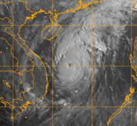
Typhoon Neoguri was the earliest tropical cyclone
on record to strike The People's Republic of China. The first named storm in the 2008 Pacific typhoon season
, named after the Korean
word for raccoon dog
, it formed from a low pressure area
on April 13 to the east of the Philippine
island of Mindanao
, and after crossing the island it intensified into a tropical storm in the South China Sea
. Environmental conditions allowed for quick strengthening, with Neoguri attaining typhoon status on April 16. The typhoon reached its peak intensity on April 18 as it approached the island of Hainan
, and subsequently it turned northward. Due to increased wind shear
and cooler waters, Neoguri rapidly weakened and made landfall
as a minimal tropical storm in southern China on April 19.
In the southern Philippines, the storm brought heavy rainfall, which left a person missing when a boat capsized. The typhoon left 40 fishermen missing in the South China Sea. Neoguri brought heavy rainfall as it made its final landfall on China, causing moderate damage totaling over ¥296 million (2008 RMB
, $42 million 2008 USD). Three deaths occurred in China.
persisted east-northeast of Palau
on April 11 in association with a sharp easterly wave
, and within the system, a low pressure area
was evident between Palau and Yap
. Located beneath a developing anticyclone
, with limited wind shear
and enhanced diffluence
, the system encountered favorable conditions for development. By April 13, a low-level circulation had formed and started consolidating about 260 km (160 mi) southeast of Bislig City
on Mindanao
island in the Philippines
. At around the same time, weak rainbands began wrapping into the center. At 1200 UTC
on April 13, the JMA
classified it as a weak tropical depression. Its development was impeded somewhat as it crossed Mindanao and Negros island, though the circulation consolidated while convective banding features increased. Later that day, the Philippine Atmospheric, Geophysical and Astronomical Services Administration
(PAGASA) classified the system as Tropical Depression Ambo, and early on April 14 the Joint Typhoon Warning Center
(JTWC) classified it as Tropical Depression 02W about 300 km (185 mi north of the Zamboanga Peninsula
. Also, PAGASA declared "Ambo" at 0300 UTC April 14 to be within Dumaguete City
.
The depression continued westward, along the southern periphery of a strong subtropical ridge
extending from southeastern Asia to north of Luzon
. After it entered the Sulu Sea
, the convection and circulation continued to consolidate, while its anticyclone aloft provided excellent outflow
. Based on satellite intensity estimates using the Dvorak technique
, the JTWC upgraded the depression to Tropical Storm 02W midday on April 14. At 0000 UTC on April 15, the JMA classified the system as a full tropical depression, and six hours later the agency upgraded it to Tropical Storm Neoguri after it crossed Palawan
island into the South China Sea
. Shortly thereafter, the PAGASA issued its last advisory on the cyclone as the storm moved out of their area of warning responsibility.
After attaining tropical storm status, significant intensification was limited due to a slight increase in wind shear as well as impeded outflow. The slowing of the strengthening trend was temporary, and by early on April 16 the organization had rapidly improved. As a result, the JMA upgraded Neoguri to a severe tropical storm. Warm water temperatures contributed to further intensification, and an eye
formed in the center of the convection. At 1200 UTC on April 16, the JMA classified Neoguri as a typhoon about 350 km (220 mi) east of Qui Nhon
, Vietnam
. An approaching mid-level trough
turned the typhoon northwestward, which enhanced outflow and contributed to further intensification. Late on April 17, the JTWC assessed Neoguri as attaining peak winds of 175 km/h (110 mph), averaged over a duration of one minute, near the Paracel Islands
. Early the next day, the JMA estimated Neoguri reached its peak intensity with ten minute sustained winds of 150 km/h (90 mph), about 190 km (120 mi) east of Sanya
on the southern tip of Hainan
.
 Typhoon Neoguri underwent an eyewall replacement cycle around the time it reached peak intensity; the inner eyewall collapsed, and the outer eyewall contracted to a diameter of 65 km (40 mi). Upon attaining peak winds, the typhoon had turned northward, and the China Meteorological Administration
assessed Neoguri as moving ashore along Hainan island near Wenchang
. However, other agencies assessed the typhoon as tracking parallel to the eastern coastline just offshore. Land interaction and wind shear weakened the typhoon, and by April 19 it had weakened to a tropical storm. Cooler waters contributed to further weakening, causing its convection to diminish significantly and for its circulation to become elongated. After turning to the north-northeast, Neoguri made landfall
on Guangdong
province in southern China, a short distance west of Macau
as a weak tropical storm. Neoguri made landfall on China earlier than any other tropical cyclone on record, about two weeks prior to the previous record set by Typhoon Wanda in 1971
. Shortly after moving ashore, the JTWC issued its final warning as the cyclone began dissipating
.
, Southern Leyte
, Siquijor
and Camiguin
. This storm signal was later scaled back up until the storm reached Palawan
and the South China Sea
.
As a tropical depression, Neoguri (Ambo) brought heavy rainfall to many portions of the Philippines
, including even Metro Manila
. In Cebu City
, the precipitation caused flooding, which forced 62 people to evacuate their houses. In the Camotes Islands
, rough waves capsized a motorboat with six passengers; five were rescued, with the other reported missing. But the storm at least alleviated for a few days the heat that has been experienced over Luzon
from the past weeks. However, the storm did not stop the Palarong Pambansa (National Games in the Philippines) which was held in Puerto Princesa City
in Palawan
, one of the areas said by PAGASA to see stormy weather.
 In preparation for the storm, about 21,800 fishing boats in the Chinese province of Hainan
returned to port, and about 120,000 people evacuated from fish farms and low-lying areas on the island. Officials halted ferry service between Hainan and the Leizhou Peninsula
in Guangdong
province. Offshore, 56 fishermen rode out the storm in a shelter on the Paracel Islands
; 38 people were rescued shortly after the storm, and initially eighteen people were reported missing. The eighteen missing fishermen were found thirty hours after Neoguri struck. The ship they were on had sunk, and the crew clung to debris and made makeshift rafts to survive in the waters. However, another 18 Chinese fisherman and 22 Vietnamese fisherman remain missing. On Hainan island, the storm left the city of Wenchang without power.
Along the mainland, ferry service was temporarily stopped between Hong Kong
and Macau
. At the Hong Kong International Airport
, over 200 flights were delayed due to the threat of the storm; additionally, around 30 were canceled, and 66 others were deviated elsewhere. The Hong Kong Observatory
issued a standby warning signal
on April 17, which was the second earliest standby signal on record. One day later, the No. 3 strong wind signal was issued, the earliest in record. As it moved ashore, the storm brought heavy rainfall, with one station reporting 237 mm (9.35 in) in one day. Strong winds downed coconut and banana trees, with agricultural damage totaling over ¥200 million (2008 RMB
, $28 million 2008 USD). Structural damage amounted to ¥96 million (2008 RMB, $14 million 2008 USD). Three fatalities were confirmed in China, two due to a road being covered in a mud flow, and another due to winds blowing a sheet of aluminum into a person, throwing them off the roof of a stadium.
Tropical cyclone
A tropical cyclone is a storm system characterized by a large low-pressure center and numerous thunderstorms that produce strong winds and heavy rain. Tropical cyclones strengthen when water evaporated from the ocean is released as the saturated air rises, resulting in condensation of water vapor...
on record to strike The People's Republic of China. The first named storm in the 2008 Pacific typhoon season
2008 Pacific typhoon season
The 2008 Pacific typhoon season has no official bounds; it runs year-round in 2008, but most tropical cyclones tend to form in the northwestern Pacific Ocean between May and November...
, named after the Korean
Korean language
Korean is the official language of the country Korea, in both South and North. It is also one of the two official languages in the Yanbian Korean Autonomous Prefecture in People's Republic of China. There are about 78 million Korean speakers worldwide. In the 15th century, a national writing...
word for raccoon dog
Raccoon Dog
The raccoon dog , also known as the magnut or tanuki, is a canid indigenous to east Asia. It is the only extant species in the genus Nyctereutes...
, it formed from a low pressure area
Low pressure area
A low-pressure area, or "low", is a region where the atmospheric pressure at sea level is below that of surrounding locations. Low-pressure systems form under areas of wind divergence which occur in upper levels of the troposphere. The formation process of a low-pressure area is known as...
on April 13 to the east of the Philippine
Philippines
The Philippines , officially known as the Republic of the Philippines , is a country in Southeast Asia in the western Pacific Ocean. To its north across the Luzon Strait lies Taiwan. West across the South China Sea sits Vietnam...
island of Mindanao
Mindanao
Mindanao is the second largest and easternmost island in the Philippines. It is also the name of one of the three island groups in the country, which consists of the island of Mindanao and smaller surrounding islands. The other two are Luzon and the Visayas. The island of Mindanao is called The...
, and after crossing the island it intensified into a tropical storm in the South China Sea
South China Sea
The South China Sea is a marginal sea that is part of the Pacific Ocean, encompassing an area from the Singapore and Malacca Straits to the Strait of Taiwan of around...
. Environmental conditions allowed for quick strengthening, with Neoguri attaining typhoon status on April 16. The typhoon reached its peak intensity on April 18 as it approached the island of Hainan
Hainan
Hainan is the smallest province of the People's Republic of China . Although the province comprises some two hundred islands scattered among three archipelagos off the southern coast, of its land mass is Hainan Island , from which the province takes its name...
, and subsequently it turned northward. Due to increased wind shear
Wind shear
Wind shear, sometimes referred to as windshear or wind gradient, is a difference in wind speed and direction over a relatively short distance in the atmosphere...
and cooler waters, Neoguri rapidly weakened and made landfall
Landfall (meteorology)
Landfall is the event of a tropical cyclone or a waterspout coming onto land after being over water. When a waterspout makes landfall it is reclassified as a tornado, which can then cause damage inland...
as a minimal tropical storm in southern China on April 19.
In the southern Philippines, the storm brought heavy rainfall, which left a person missing when a boat capsized. The typhoon left 40 fishermen missing in the South China Sea. Neoguri brought heavy rainfall as it made its final landfall on China, causing moderate damage totaling over ¥296 million (2008 RMB
Renminbi
The Renminbi is the official currency of the People's Republic of China . Renminbi is legal tender in mainland China, but not in Hong Kong or Macau. It is issued by the People's Bank of China, the monetary authority of the PRC...
, $42 million 2008 USD). Three deaths occurred in China.
Meteorological history
An area of disorganized convectionConvection
Convection is the movement of molecules within fluids and rheids. It cannot take place in solids, since neither bulk current flows nor significant diffusion can take place in solids....
persisted east-northeast of Palau
Palau
Palau , officially the Republic of Palau , is an island nation in the Pacific Ocean, east of the Philippines and south of Tokyo. In 1978, after three decades as being part of the United Nations trusteeship, Palau chose independence instead of becoming part of the Federated States of Micronesia, a...
on April 11 in association with a sharp easterly wave
Tropical wave
Tropical waves, easterly waves, or tropical easterly waves, also known as African easterly waves in the Atlantic region, are a type of atmospheric trough, an elongated area of relatively low air pressure, oriented north to south, which move from east to west across the tropics causing areas of...
, and within the system, a low pressure area
Low pressure area
A low-pressure area, or "low", is a region where the atmospheric pressure at sea level is below that of surrounding locations. Low-pressure systems form under areas of wind divergence which occur in upper levels of the troposphere. The formation process of a low-pressure area is known as...
was evident between Palau and Yap
Yap
Yap, also known as Wa'ab by locals, is an island in the Caroline Islands of the western Pacific Ocean. It is a state of the Federated States of Micronesia. Yap's indigenous cultures and traditions are still strong compared to other neighboring islands. The island of Yap actually consists of four...
. Located beneath a developing anticyclone
Anticyclone
An anticyclone is a weather phenomenon defined by the United States' National Weather Service's glossary as "[a] large-scale circulation of winds around a central region of high atmospheric pressure, clockwise in the Northern Hemisphere, counterclockwise in the Southern Hemisphere"...
, with limited wind shear
Wind shear
Wind shear, sometimes referred to as windshear or wind gradient, is a difference in wind speed and direction over a relatively short distance in the atmosphere...
and enhanced diffluence
Deformation (meteorology)
Deformation is the rate of change of shape of fluid bodies. Meteorologically, this quantity is very important in the formation of atmospheric fronts, in the explanation of cloud shapes, and in the diffusion of materials and properties.-Equations:...
, the system encountered favorable conditions for development. By April 13, a low-level circulation had formed and started consolidating about 260 km (160 mi) southeast of Bislig City
Bislig City
Bislig City is a 3rd class city in the province of Surigao del Sur, Mindanao, Philippines. Bislig is approximately 208 kilometers northeast of Davao City, 152 kilometers south of Tandag City and 158 southeast of Butuan City...
on Mindanao
Mindanao
Mindanao is the second largest and easternmost island in the Philippines. It is also the name of one of the three island groups in the country, which consists of the island of Mindanao and smaller surrounding islands. The other two are Luzon and the Visayas. The island of Mindanao is called The...
island in the Philippines
Philippines
The Philippines , officially known as the Republic of the Philippines , is a country in Southeast Asia in the western Pacific Ocean. To its north across the Luzon Strait lies Taiwan. West across the South China Sea sits Vietnam...
. At around the same time, weak rainbands began wrapping into the center. At 1200 UTC
Coordinated Universal Time
Coordinated Universal Time is the primary time standard by which the world regulates clocks and time. It is one of several closely related successors to Greenwich Mean Time. Computer servers, online services and other entities that rely on having a universally accepted time use UTC for that purpose...
on April 13, the JMA
Japan Meteorological Agency
The or JMA, is the Japanese government's weather service. Charged with gathering and reporting weather data and forecasts in Japan, it is a semi-autonomous part of the Ministry of Land, Infrastructure and Transport...
classified it as a weak tropical depression. Its development was impeded somewhat as it crossed Mindanao and Negros island, though the circulation consolidated while convective banding features increased. Later that day, the Philippine Atmospheric, Geophysical and Astronomical Services Administration
Philippine Atmospheric, Geophysical and Astronomical Services Administration
The Philippine Atmospheric, Geophysical and Astronomical Services Administration is a Philippine national institution dedicated to provide flood and typhoon warnings, public weather forecasts and advisories, meteorological, astronomical, climatological, and other specialized information and...
(PAGASA) classified the system as Tropical Depression Ambo, and early on April 14 the Joint Typhoon Warning Center
Joint Typhoon Warning Center
The Joint Typhoon Warning Center is a joint United States Navy – United States Air Force task force located at the Naval Maritime Forecast Center in Pearl Harbor, Hawaii...
(JTWC) classified it as Tropical Depression 02W about 300 km (185 mi north of the Zamboanga Peninsula
Zamboanga Peninsula
Zamboanga Peninsula / Western Mindanao is a peninsula and an administrative region in the Philippines. Designated as Region IX, the region consists of three provinces, namely, Zamboanga del Norte, Zamboanga del Sur, and Zamboanga Sibugay, its component cities of Dipolog, Dapitan, Pagadian, and...
. Also, PAGASA declared "Ambo" at 0300 UTC April 14 to be within Dumaguete City
Dumaguete City
The City of Dumaguete is a city in the Philippine province of Negros Oriental. It is the capital, principal seaport, and largest city of the province. According to the 2010 census, it has a population of 133,470 people. A person from Dumaguete is called a "Dumagueteño"...
.
The depression continued westward, along the southern periphery of a strong subtropical ridge
Subtropical ridge
The subtropical ridge is a significant belt of high pressure situated around the latitudes of 30°N in the Northern Hemisphere and 30°S in the Southern Hemisphere. It is characterized by mostly calm winds, which acts to reduce air quality under its axis by causing fog overnight, and haze during...
extending from southeastern Asia to north of Luzon
Luzon
Luzon is the largest island in the Philippines. It is located in the northernmost region of the archipelago, and is also the name for one of the three primary island groups in the country centered on the Island of Luzon...
. After it entered the Sulu Sea
Sulu Sea
The Sulu Sea is a body of water in the southwestern area of the Philippines, separated from the South China Sea in the northwest by Palawan and from the Celebes Sea in the southeast by the Sulu Archipelago. Borneo is found to the southwest and Visayas to the northeast.Sulu Sea contains a number of...
, the convection and circulation continued to consolidate, while its anticyclone aloft provided excellent outflow
Outflow (meteorology)
Outflow, in meteorology, is air that flows outwards from a storm system. It is associated with ridging, or anticyclonic flow. In the low levels of the troposphere, outflow radiates from thunderstorms in the form of a wedge of rain-cooled air, which is visible as a thin rope-like cloud on weather...
. Based on satellite intensity estimates using the Dvorak technique
Dvorak technique
The Dvorak technique is a widely used system to subjectively estimate tropical cyclone intensity based solely on visible and infrared satellite images. Several agencies issue Dvorak intensity numbers for cyclones of sufficient intensity...
, the JTWC upgraded the depression to Tropical Storm 02W midday on April 14. At 0000 UTC on April 15, the JMA classified the system as a full tropical depression, and six hours later the agency upgraded it to Tropical Storm Neoguri after it crossed Palawan
Palawan
Palawan is an island province of the Philippines located in the MIMAROPA region or Region 4. Its capital is Puerto Princesa City, and it is the largest province in the country in terms of total area of jurisdiction. The islands of Palawan stretch from Mindoro in the northeast to Borneo in the...
island into the South China Sea
South China Sea
The South China Sea is a marginal sea that is part of the Pacific Ocean, encompassing an area from the Singapore and Malacca Straits to the Strait of Taiwan of around...
. Shortly thereafter, the PAGASA issued its last advisory on the cyclone as the storm moved out of their area of warning responsibility.
After attaining tropical storm status, significant intensification was limited due to a slight increase in wind shear as well as impeded outflow. The slowing of the strengthening trend was temporary, and by early on April 16 the organization had rapidly improved. As a result, the JMA upgraded Neoguri to a severe tropical storm. Warm water temperatures contributed to further intensification, and an eye
Eye (cyclone)
The eye is a region of mostly calm weather found at the center of strong tropical cyclones. The eye of a storm is a roughly circular area and typically 30–65 km in diameter. It is surrounded by the eyewall, a ring of towering thunderstorms where the second most severe weather of a cyclone...
formed in the center of the convection. At 1200 UTC on April 16, the JMA classified Neoguri as a typhoon about 350 km (220 mi) east of Qui Nhon
Qui Nhon
Qui Nhơn , also Quy Nhơn, is a coastal city in Binh Dinh province in central Vietnam. It is composed of 16 wards and five communes with a total of 286 km². Quy Nhon is the capital of Bình Định province. As of 2009 its population was 280,900. Historically, the commercial activities of the city...
, Vietnam
Vietnam
Vietnam – sometimes spelled Viet Nam , officially the Socialist Republic of Vietnam – is the easternmost country on the Indochina Peninsula in Southeast Asia. It is bordered by China to the north, Laos to the northwest, Cambodia to the southwest, and the South China Sea –...
. An approaching mid-level trough
Trough (meteorology)
A trough is an elongated region of relatively low atmospheric pressure, often associated with fronts.Unlike fronts, there is not a universal symbol for a trough on a weather chart. The weather charts in some countries or regions mark troughs by a line. In the United States, a trough may be marked...
turned the typhoon northwestward, which enhanced outflow and contributed to further intensification. Late on April 17, the JTWC assessed Neoguri as attaining peak winds of 175 km/h (110 mph), averaged over a duration of one minute, near the Paracel Islands
Paracel Islands
The Paracel Islands, also called Xisha Islands in Chinese and Hoàng Sa Islands in Vietnamese, is a group of islands under the administration of Hainan Province, The People's Republic of China. Vietnam and the Republic of China also claim sovereignty of these islands...
. Early the next day, the JMA estimated Neoguri reached its peak intensity with ten minute sustained winds of 150 km/h (90 mph), about 190 km (120 mi) east of Sanya
Sanya
Sanya is the southernmost city in China and is a part of Hainan Province. In 2006, it had a population of 536,000, making it, after the provincial capital , the second most populous city on the island. The city is renowned for its tropical climate and has emerged as a popular tourist destination,...
on the southern tip of Hainan
Hainan
Hainan is the smallest province of the People's Republic of China . Although the province comprises some two hundred islands scattered among three archipelagos off the southern coast, of its land mass is Hainan Island , from which the province takes its name...
.
China Meteorological Administration
The China Meteorological Administration , headquartered in Beijing, is the national weather service for the People's Republic of China.-History:...
assessed Neoguri as moving ashore along Hainan island near Wenchang
Wenchang
Wenchang is a county-level city located in the north east of Hainan province, China. It was promoted from a county to a city on November 7, 1995, and had a population of 86,551 in 1999...
. However, other agencies assessed the typhoon as tracking parallel to the eastern coastline just offshore. Land interaction and wind shear weakened the typhoon, and by April 19 it had weakened to a tropical storm. Cooler waters contributed to further weakening, causing its convection to diminish significantly and for its circulation to become elongated. After turning to the north-northeast, Neoguri made landfall
Landfall (meteorology)
Landfall is the event of a tropical cyclone or a waterspout coming onto land after being over water. When a waterspout makes landfall it is reclassified as a tornado, which can then cause damage inland...
on Guangdong
Guangdong
Guangdong is a province on the South China Sea coast of the People's Republic of China. The province was previously often written with the alternative English name Kwangtung Province...
province in southern China, a short distance west of Macau
Macau
Macau , also spelled Macao , is, along with Hong Kong, one of the two special administrative regions of the People's Republic of China...
as a weak tropical storm. Neoguri made landfall on China earlier than any other tropical cyclone on record, about two weeks prior to the previous record set by Typhoon Wanda in 1971
1971 Pacific typhoon season
The 1971 Pacific typhoon season has no official bounds; it ran year-round in 1971, but most tropical cyclones tend to form in the northwestern Pacific Ocean between June and December...
. Shortly after moving ashore, the JTWC issued its final warning as the cyclone began dissipating
Dissipation
In physics, dissipation embodies the concept of a dynamical system where important mechanical models, such as waves or oscillations, lose energy over time, typically from friction or turbulence. The lost energy converts into heat, which raises the temperature of the system. Such systems are called...
.
Preparations and impact
As Ambo (Neoguri) passed directly through many parts Visayas and Mindanao, PAGASA issued Public Storm Warning Signals for these areas. Signal number one was issued for southern Negros, southern Cebu, BoholBohol
Bohol is an island province of the Philippines located in the Central Visayas region, consisting of Bohol Island and 75 minor surrounding islands. Its capital is Tagbilaran City. With a land area of and a coastline long, Bohol is the tenth largest island of the Philippines...
, Southern Leyte
Southern Leyte
Southern Leyte is a province of the Philippines located in the Eastern Visayas region. Maasin City is the capital of the province. Southern Leyte was once a sub-province of Leyte before it was divided from the latter...
, Siquijor
Siquijor
Siquijor is an island province of the Philippines located in the Central Visayas region. Its capital is the municipality also named Siquijor. To the northwest of Siquijor are Cebu and Negros, to the northeast is Bohol and to the south, across the Bohol Sea, is Mindanao.Siquijor is the third...
and Camiguin
Camiguin
Camiguin is an island province of the Philippines located in the Bohol Sea, about off the northern coast of Misamis Oriental in Mindanao. It is the second-smallest province both in population and land area after Batanes...
. This storm signal was later scaled back up until the storm reached Palawan
Palawan
Palawan is an island province of the Philippines located in the MIMAROPA region or Region 4. Its capital is Puerto Princesa City, and it is the largest province in the country in terms of total area of jurisdiction. The islands of Palawan stretch from Mindoro in the northeast to Borneo in the...
and the South China Sea
South China Sea
The South China Sea is a marginal sea that is part of the Pacific Ocean, encompassing an area from the Singapore and Malacca Straits to the Strait of Taiwan of around...
.
As a tropical depression, Neoguri (Ambo) brought heavy rainfall to many portions of the Philippines
Philippines
The Philippines , officially known as the Republic of the Philippines , is a country in Southeast Asia in the western Pacific Ocean. To its north across the Luzon Strait lies Taiwan. West across the South China Sea sits Vietnam...
, including even Metro Manila
Metro Manila
Metropolitan Manila , the National Capital Region , or simply Metro Manila, is the metropolitan region encompassing the City of Manila and its surrounding areas in the Philippines...
. In Cebu City
Cebu City
The City of Cebu is the capital city of Cebu and is the second largest city in the Philippines, the second most significant metropolitan centre in the Philippines and known as the oldest settlement established by the Spaniards in the country.The city is located on the eastern shore of Cebu and was...
, the precipitation caused flooding, which forced 62 people to evacuate their houses. In the Camotes Islands
Camotes Islands
The Camotes Islands are a group of islands that form part of the province of Cebu, in the Philippines. The island group is located east of Cebu Island, southwest of Leyte Island, and north of Bohol Island....
, rough waves capsized a motorboat with six passengers; five were rescued, with the other reported missing. But the storm at least alleviated for a few days the heat that has been experienced over Luzon
Luzon
Luzon is the largest island in the Philippines. It is located in the northernmost region of the archipelago, and is also the name for one of the three primary island groups in the country centered on the Island of Luzon...
from the past weeks. However, the storm did not stop the Palarong Pambansa (National Games in the Philippines) which was held in Puerto Princesa City
Puerto Princesa City
The City of Puerto Princesa is a city located on the western provincial island of Palawan, one of 80 provinces which make up the Philippines...
in Palawan
Palawan
Palawan is an island province of the Philippines located in the MIMAROPA region or Region 4. Its capital is Puerto Princesa City, and it is the largest province in the country in terms of total area of jurisdiction. The islands of Palawan stretch from Mindoro in the northeast to Borneo in the...
, one of the areas said by PAGASA to see stormy weather.
Hainan
Hainan is the smallest province of the People's Republic of China . Although the province comprises some two hundred islands scattered among three archipelagos off the southern coast, of its land mass is Hainan Island , from which the province takes its name...
returned to port, and about 120,000 people evacuated from fish farms and low-lying areas on the island. Officials halted ferry service between Hainan and the Leizhou Peninsula
Leizhou Peninsula
The Leizhou Peninsula or Leizhou Bandao is a peninsula in the southernmost part of Guangdong province in southern China.-Geography:Leizhou Peninsula is the third largest peninsula in China with an area of of circa 8,500 square kilometer located on the southwestern end of Guangdong, with the Gulf...
in Guangdong
Guangdong
Guangdong is a province on the South China Sea coast of the People's Republic of China. The province was previously often written with the alternative English name Kwangtung Province...
province. Offshore, 56 fishermen rode out the storm in a shelter on the Paracel Islands
Paracel Islands
The Paracel Islands, also called Xisha Islands in Chinese and Hoàng Sa Islands in Vietnamese, is a group of islands under the administration of Hainan Province, The People's Republic of China. Vietnam and the Republic of China also claim sovereignty of these islands...
; 38 people were rescued shortly after the storm, and initially eighteen people were reported missing. The eighteen missing fishermen were found thirty hours after Neoguri struck. The ship they were on had sunk, and the crew clung to debris and made makeshift rafts to survive in the waters. However, another 18 Chinese fisherman and 22 Vietnamese fisherman remain missing. On Hainan island, the storm left the city of Wenchang without power.
Along the mainland, ferry service was temporarily stopped between Hong Kong
Hong Kong
Hong Kong is one of two Special Administrative Regions of the People's Republic of China , the other being Macau. A city-state situated on China's south coast and enclosed by the Pearl River Delta and South China Sea, it is renowned for its expansive skyline and deep natural harbour...
and Macau
Macau
Macau , also spelled Macao , is, along with Hong Kong, one of the two special administrative regions of the People's Republic of China...
. At the Hong Kong International Airport
Hong Kong International Airport
Hong Kong International Airport is the main airport in Hong Kong. It is colloquially known as Chek Lap Kok Airport , being built on the island of Chek Lap Kok by land reclamation, and also to distinguish it from its predecessor, the closed Kai Tak Airport.The airport opened for commercial...
, over 200 flights were delayed due to the threat of the storm; additionally, around 30 were canceled, and 66 others were deviated elsewhere. The Hong Kong Observatory
Hong Kong Observatory
Hong Kong Observatory is a department of the Hong Kong government. The Observatory forecasts weather and issues warnings on weather-related hazards...
issued a standby warning signal
Hong Kong Tropical Cyclone Warning Signals
The Hong Kong tropical cyclone warning signals or informally typhoon signals are a set of signals used to indicate the threat or effects of a tropical cyclone. The Hong Kong Observatory issues the warning signal if a tropical cyclone is centred within of Hong Kong and may affect Hong Kong later...
on April 17, which was the second earliest standby signal on record. One day later, the No. 3 strong wind signal was issued, the earliest in record. As it moved ashore, the storm brought heavy rainfall, with one station reporting 237 mm (9.35 in) in one day. Strong winds downed coconut and banana trees, with agricultural damage totaling over ¥200 million (2008 RMB
Renminbi
The Renminbi is the official currency of the People's Republic of China . Renminbi is legal tender in mainland China, but not in Hong Kong or Macau. It is issued by the People's Bank of China, the monetary authority of the PRC...
, $28 million 2008 USD). Structural damage amounted to ¥96 million (2008 RMB, $14 million 2008 USD). Three fatalities were confirmed in China, two due to a road being covered in a mud flow, and another due to winds blowing a sheet of aluminum into a person, throwing them off the roof of a stadium.
See also
- Other storms of the same nameTyphoon NeoguriThe name Neoguri has been used to name one tropical cyclone in the western north Pacific Ocean. In addition, the erroneous Noguri was used in 2002 before the spelling was corrected by the WMO Typhoon Committee...
- Timeline of the 2008 Pacific typhoon seasonTimeline of the 2008 Pacific typhoon seasonThis timeline documents all the storm formations, strengthening, weakening, landfalls, extratropical transitions, as well as dissipation during the 2008 Pacific typhoon season. The 2008 Pacific typhoon season officially started on January 1, 2008 and ended on January 1, 2009. The first tropical...