
Tupungato
Encyclopedia
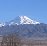
Tupungato, one of the highest mountain
s in South America
, is a massive stratovolcano
dating to Pleistocene
times. It lies on the border between the Chile
an Metropolitan Region and the , near a major international highway about 80 km (50 mi) east of Santiago, Chile
. It is located about 100 km (62 mi) south of Monte Aconcagua
, the highest peak of the American continent. Immediately to its southwest lies the active Tupungatito
volcano, which last erupted in 1987.
The mountain gives its name to the Tupungato Department
an important Argentine wine
producing region in the Mendoza province, Argentina
.
carrying six passengers and five crew over the Andes
range, crashed into a steep glacier
high on Tupungato. The plane was quickly buried in the resulting avalanche
and heavy snowfall that was taking place at the time. The plane lay undetected deep beneath the snow and glacial ice for over 50 years, before its remnants finally re-emerged at the glacier terminus
in 2000. Shortly thereafter, a team discovered the scattered debris and wreckage, collecting some of the evidence for investigation.
Mountain
Image:Himalaya_annotated.jpg|thumb|right|The Himalayan mountain range with Mount Everestrect 58 14 160 49 Chomo Lonzorect 200 28 335 52 Makalurect 378 24 566 45 Mount Everestrect 188 581 920 656 Tibetan Plateaurect 250 406 340 427 Rong River...
s in South America
South America
South America is a continent situated in the Western Hemisphere, mostly in the Southern Hemisphere, with a relatively small portion in the Northern Hemisphere. The continent is also considered a subcontinent of the Americas. It is bordered on the west by the Pacific Ocean and on the north and east...
, is a massive stratovolcano
Stratovolcano
A stratovolcano, also known as a composite volcano, is a tall, conical volcano built up by many layers of hardened lava, tephra, pumice, and volcanic ash. Unlike shield volcanoes, stratovolcanoes are characterized by a steep profile and periodic, explosive eruptions...
dating to Pleistocene
Pleistocene
The Pleistocene is the epoch from 2,588,000 to 11,700 years BP that spans the world's recent period of repeated glaciations. The name pleistocene is derived from the Greek and ....
times. It lies on the border between the Chile
Chile
Chile ,officially the Republic of Chile , is a country in South America occupying a long, narrow coastal strip between the Andes mountains to the east and the Pacific Ocean to the west. It borders Peru to the north, Bolivia to the northeast, Argentina to the east, and the Drake Passage in the far...
an Metropolitan Region and the , near a major international highway about 80 km (50 mi) east of Santiago, Chile
Santiago, Chile
Santiago , also known as Santiago de Chile, is the capital and largest city of Chile, and the center of its largest conurbation . It is located in the country's central valley, at an elevation of above mean sea level...
. It is located about 100 km (62 mi) south of Monte Aconcagua
Aconcagua
Aconcagua is the highest mountain in the Americas at . It is located in the Andes mountain range, in the Argentine province of Mendoza and it lies west by north of its capital, the city of Mendoza. The summit is also located about 5 kilometres from San Juan Province and 15 kilometres from the...
, the highest peak of the American continent. Immediately to its southwest lies the active Tupungatito
Tupungatito
Volcán Tupungatito is the northernmost historically active stratovolcano of the southern Andes. It lies on the border between Argentina and Chile, about east of Santiago, Chile, and immediately southwest of the massive Cerro Tupungato stratovolcano. Its name is a diminutive homonym, just as in...
volcano, which last erupted in 1987.
The mountain gives its name to the Tupungato Department
Tupungato Department
Tupungato is a department located in the province of Mendoza, Argentina. The cabecera 0f Tupungato is located approximately 70 km south of Mendoza city, in the Valle de Uco....
an important Argentine wine
Argentine wine
The Argentine wine industry is the fifth largest producer of wine in the world. Argentine wine, as with some aspects of Argentine cuisine, has its roots in Spain...
producing region in the Mendoza province, Argentina
Argentina
Argentina , officially the Argentine Republic , is the second largest country in South America by land area, after Brazil. It is constituted as a federation of 23 provinces and an autonomous city, Buenos Aires...
.
1947 plane crash
On August 2, 1947, the airliner Star Dust, an Avro LancastrianAvro Lancastrian
|-See also:-References:NotesBibliography* Franks, Richard A. The Avro Lancaster, Manchester and Lincoln: A Comprehensive Guide for the Modeller. London: SAM Publications, 2000. ISBN 0-9533465-3-6....
carrying six passengers and five crew over the Andes
Andes
The Andes is the world's longest continental mountain range. It is a continual range of highlands along the western coast of South America. This range is about long, about to wide , and of an average height of about .Along its length, the Andes is split into several ranges, which are separated...
range, crashed into a steep glacier
Glacier
A glacier is a large persistent body of ice that forms where the accumulation of snow exceeds its ablation over many years, often centuries. At least 0.1 km² in area and 50 m thick, but often much larger, a glacier slowly deforms and flows due to stresses induced by its weight...
high on Tupungato. The plane was quickly buried in the resulting avalanche
Avalanche
An avalanche is a sudden rapid flow of snow down a slope, occurring when either natural triggers or human activity causes a critical escalating transition from the slow equilibrium evolution of the snow pack. Typically occurring in mountainous terrain, an avalanche can mix air and water with the...
and heavy snowfall that was taking place at the time. The plane lay undetected deep beneath the snow and glacial ice for over 50 years, before its remnants finally re-emerged at the glacier terminus
Glacier terminus
A glacier terminus, or snout, is the end of a glacier at any given point in time. Although glaciers seem motionless to the observer, in reality glaciers are in endless motion and the glacier terminus is always either advancing or retreating...
in 2000. Shortly thereafter, a team discovered the scattered debris and wreckage, collecting some of the evidence for investigation.