

Tunnel valley
Encyclopedia
A tunnel valley can be up to 100 km (62.1 mi) long, 4 km (2.5 mi) wide, and 400 m (1,312.3 ft) deep (its depth may vary along its length).
Tunnel valleys were formed by subglacial erosion by water and served as subglacial drainage pathways carrying large volumes of melt water. Their cross-sections exhibit steep-sided flanks similar to fjord
Fjord
Geologically, a fjord is a long, narrow inlet with steep sides or cliffs, created in a valley carved by glacial activity.-Formation:A fjord is formed when a glacier cuts a U-shaped valley by abrasion of the surrounding bedrock. Glacial melting is accompanied by rebound of Earth's crust as the ice...
walls, and their flat bottoms are typical of subglacial glacial erosion.
They presently appear as dry valleys, lakes, seabed depressions, and as areas filled with sediment. If they are filled with sediment, their lower layers are filled primarily with glacial, glaciofluvial or glaciolacustrine
Glaciolacustrine deposits
Sediments deposited into lakes that have come from glaciers are called glaciolacustrine deposits. These lakes include ice margin lakes or other types formed from glacial erosion or deposition. Sediments in the bedload and suspended load are carried into lakes and deposited...
sediment, supplemented by upper layers of temperate infill. They can be found in areas formerly covered by glacial ice sheets including Africa, Asia, North America, Europe, Australia and offshore in the North Sea, the Atlantic and in waters near Antarctica.
Tunnel valleys appear in the technical literature under several terms, including tunnel channels, subglacial valleys, iceway
Iceway
An iceway is a linear channel eroded through bedrock by the passage of glacial ice. The term was coined by geographer Ronald Kay Gresswell in a paper in 1964 in relation to the origins of the Dee and Mersey estuaries on the boundary of northwest England and northeast Wales...
s, snake coils
Snake coils (geology)
Snake coils is a descriptive term used by physical geologist and glaciologists to describe the "snake coil"-like shape that occurs along certain ablation lines. Essentially miniature tunnel valleys, the peculiar natural shapes were first described by French Geologist Jean-Jerome Peytavi in 1973...
and linear incisions.
Significance
Understanding tunnel valleys is important because:- They serve as a marker for areas with the potential for effective oil exploration in Africa,
- Their bedrock boundaries and glacial infill makes them effective aquifers in many regions.
- Soil engineers must accommodate the variations which they exhibit when boring tunnels, establishing foundations, and
- They provide one of several signatures marking the edge of former glaciations.
Tunnel valleys play a useful role in identifying oil rich areas in Arabia and North Africa
North Africa
North Africa or Northern Africa is the northernmost region of the African continent, linked by the Sahara to Sub-Saharan Africa. Geopolitically, the United Nations definition of Northern Africa includes eight countries or territories; Algeria, Egypt, Libya, Morocco, South Sudan, Sudan, Tunisia, and...
. The Upper Ordovician
Ordovician
The Ordovician is a geologic period and system, the second of six of the Paleozoic Era, and covers the time between 488.3±1.7 to 443.7±1.5 million years ago . It follows the Cambrian Period and is followed by the Silurian Period...
–Lower Silurian
Silurian
The Silurian is a geologic period and system that extends from the end of the Ordovician Period, about 443.7 ± 1.5 Mya , to the beginning of the Devonian Period, about 416.0 ± 2.8 Mya . As with other geologic periods, the rock beds that define the period's start and end are well identified, but the...
materials there contain a roughly 20 m (65.6 ft) thick, carbon-rich layer of black shale. Approximately 30% of the world's oil is found in these shale deposits. Although the origin of these deposits is still under study, it has been established that the shale routinely overlies glacial and glacio-marine sediment deposited ~445 million years before the present by the Hirnantian glaciation
Hirnantian
The Hirnantian is the seventh and final internationally-recognized stage of the Ordovician Period of the Paleozoic Era. It was of short duration, lasting about 1.9 million years, from 445.6 ± 1.5 to 443.7 ± 1.5 Ma . The early part of the Hirnantian was characterized by cold temperatures, major...
. The shale has been linked to glacial meltwater nutrient enrichment of the shallow marine environment. Hence the presence of tunnel valleys is an indicator of the presence of oil in these areas.
Tunnel valleys represent a substantial fraction of all melt-water drainage from glaciers. Melt-water drainage influences the flow of glacial ice, which is important in understanding of the duration of glacial–interglacial periods and aids in identifying glacial cyclicity, a problem that is important to palaeoenvironmental investigations.
Tunnel valleys are typically eroded into bedrock and filled with glacial debris of varying sizes. This configuration makes them excellent at capturing and storing water. Hence they serve an important role as aquifer
Aquifer
An aquifer is a wet underground layer of water-bearing permeable rock or unconsolidated materials from which groundwater can be usefully extracted using a water well. The study of water flow in aquifers and the characterization of aquifers is called hydrogeology...
s across much of Northern Europe
Northern Europe
Northern Europe is the northern part or region of Europe. Northern Europe typically refers to the seven countries in the northern part of the European subcontinent which includes Denmark, Estonia, Latvia, Lithuania, Norway, Finland and Sweden...
, Canada
Canada
Canada is a North American country consisting of ten provinces and three territories. Located in the northern part of the continent, it extends from the Atlantic Ocean in the east to the Pacific Ocean in the west, and northward into the Arctic Ocean...
and the United States
United States
The United States of America is a federal constitutional republic comprising fifty states and a federal district...
. Examples include Oak Ridges Moraine Aquifer
Oak Ridges Moraine
The Oak Ridges Moraine is an ecologically important geological landform in the Mixedwood Plains of south-central Ontario, Canada. The moraine covers a geographic area of between Caledon and Rice Lake, near Peterborough...
, Spokane Valley-Rathdrum Prairie Aquifer, Mahomet Aquifer
Mahomet Aquifer
The Mahomet Aquifer is the most important aquifer in east-central Illinois. The sand and gravel aquifer is part of the buried Mahomet Bedrock Valley. It underlies 15 counties and ranges from 50 to 200 feet thick...
, the Saginaw Lobe Aquifer, and the Corning Aquifer.
Characteristics
Buried, open and partially filled
Tunnel valleys have been observed as open valleys and as partially or totally buried valleys. If buried they may be partially or totally filled with glacial outwash or other debris. The valleys may be incised in bedrock, sand, silt, or clay.A part of a tunnel valley may go uphill: water can flow uphill if it is under pressure in an enclosed pipe: for example in Doggerland
Doggerland
Doggerland is a name given by archaeologists and geologists to a former landmass in the southern North Sea that connected the island of Great Britain to mainland Europe during and after the last Ice Age, surviving until about 6,500 or 6,200 BCE, though gradually being swallowed by rising sea levels...
(submerged land which is now part of the bed of the North Sea
North Sea
In the southwest, beyond the Straits of Dover, the North Sea becomes the English Channel connecting to the Atlantic Ocean. In the east, it connects to the Baltic Sea via the Skagerrak and Kattegat, narrow straits that separate Denmark from Norway and Sweden respectively...
) are some infilled tunnel valleys that flowed from north to south across the hollow of the Outer Silver Pit
Outer Silver Pit
The Outer Silver Pit is a west-to-east valley in the bed of the North Sea. Its widest part is 125 to 175 km east of Flamborough Head in England...
.
Dimensions
They vary in channel depth and width; Danish examples run from 0.5–4 km (0.310686368324903–2.5 mi) wide and from 50 – deep. They vary in depth/altitude along their course, exhibiting overdeepeningOverdeepening
Overdeepening is a characteristic of basins and valleys eroded by glaciers. An overdeepened valley profile is often eroded to depths which are hundreds of metres below the deepest continuous line along a valley or watercourse...
; overdeepened sections cut into bedrock and typically are significantly deeper than either upstream or downstream sections of the same tunnel valley. They have steep sides which are frequently asymmetric.
Tunnel valleys frequently include relatively straight individual segments parallel to and independent of one another . Tunnel valley courses may be periodically interrupted; the interruption may include a stretch of elevated esker
Esker
An esker is a long winding ridge of stratified sand and gravel, examples of which occur in glaciated and formerly glaciated regions of Europe and North America...
, indicating the channel ran through ice for a distance. The below-grade sections typically run 5–30 km (3.1–18.6 mi) in length; in some cases the sections form a larger pattern of an interrupted channel composed of strings of depressions which can extend from 70–100 km (43.5–62.1 mi).
Structure
The upstream portion – that section furthest into the glacier - consists of a branching system forming a network, similar to the anastomosticAnastomosis
An anastomosis is the reconnection of two streams that previously branched out, such as blood vessels or leaf veins. The term is used in medicine, biology, mycology and geology....
branching patterns of the upper reaches of a river (as contrasted with dendritic patterns). They typically exhibit the largest cross-sectional area in the center of the course and terminate over a relatively short distance in elevated outwash fans at the ice-margin.
Tunnel valleys are found to cross the regional gradient - as a result they may be crosscut by modern stream networks. In one example, tributaries of the Kalamazoo River cut at nearly right angles across buried tunnel channel filled with ice and debris. They frequently terminate at a recessional moraine. Tunnel valleys from successive glaciations may crosscut one another.
Tunnel valleys frequently run along roughly parallel courses. They originate in and run through regions which include clear evidence of glacial erosion through abrasion
Abrasion (geology)
Abrasion is the mechanical scraping of a rock surface by friction between rocks and moving particles during their transport by wind, glacier, waves, gravity, running water or erosion. After friction, the moving particles dislodge loose and weak debris from the side of the rock...
and may exhibit striations and roche moutonnée
Roche moutonnée
In glaciology, a roche moutonnée is a rock formation created by the passing of a glacier. When a glacier erodes down to bedrock, it can form tear-drop shaped hills that taper in the up-ice direction.-Name:...
. Depositional forms such as terminal moraines
Moraine
A moraine is any glacially formed accumulation of unconsolidated glacial debris which can occur in currently glaciated and formerly glaciated regions, such as those areas acted upon by a past glacial maximum. This debris may have been plucked off a valley floor as a glacier advanced or it may have...
and outwash fan
Outwash fan
An outwash fan is a fan-shaped body of sediments deposited by braided streams from a melting glacier. Sediment locked within the ice of the glacier, gets transported by the streams of meltwater, and deposits on the outwash plain, at the terminus of the glacier...
s are found at their terminal end. In Michigan tunnel valley channels have been observed to diverge slightly with an average spacing between the channels of 6 km (3.7 mi) and a standard deviation
Standard deviation
Standard deviation is a widely used measure of variability or diversity used in statistics and probability theory. It shows how much variation or "dispersion" there is from the average...
of 2.7 km (1.7 mi).
Evidence of erosion mechanisms
Evidence suggests that erosion in a tunnel valley is primarily the result of water flow. They erode by meltwater, which it has been argued episodically drains in repeated jökulhlaupJökulhlaup
A jökulhlaup is a glacial outburst flood. It is an Icelandic term that has been adopted by the English language. It originally referred to the well-known subglacial outburst floods from Vatnajökull, Iceland which are triggered by geothermal heating and occasionally by a volcanic subglacial...
s from subglacially stored lakes and reservoirs; examples of such motion have been observed in Antarctica. Although there is evidence of ice erosion such as linear striations in the bedrock, these are observed only in the widest valleys, and are believed to have played a secondary role.
The subglacial layout of valley tunnels/channels is predominantly oriented parallel to glacial ice flow lines – essentially they streatch from areas of thicker sheet ice toward areas of thinner sheet ice. They can exhibit reverse gradients, which result when pressurized meltwater flows over obstacles such as ridges or hills along the glacier bed.
Tunnel valleys can be formed under extremely thick glacial ice – examples have been observed on the bottom of Lake Superior
Lake Superior
Lake Superior is the largest of the five traditionally-demarcated Great Lakes of North America. It is bounded to the north by the Canadian province of Ontario and the U.S. state of Minnesota, and to the south by the U.S. states of Wisconsin and Michigan. It is the largest freshwater lake in the...
and in the oceans offshore in Antarctica. The course of a tunnel valley typically runs from thickest glacial ice to the glacier margin; as a result the glacial ice pressurizes the water such that it runs uphill toward its end.
Formation of tunnel valleys/channels
Although there is agreement on the role of meltwater in creation of tunnel valleys, several theories are still under consideration for the role of that meltwater:- Steady state theory - Boulton and Hindmarsh propose a steady state theory. They suggest tunnel valleys form in unconsolidated sediment when meltwater flows under pressure through an initially narrow subglacial conduit. With progressive removal of sediment by meltwater, ice deforms under its own weight into the cavity to create a tunnel valley through a positive feedback mechanism.
- Jökulhlaup driven erosion - Piotrowski argues that ice sheets may, in some instances, be cold-based; that is they contact land that is frozen (permafrost) and they freeze to the permafrost. Meltwater builds up behind this frozen ice terminus until it generates sufficient pressure to lift the ice and break the bond, with a catastrophic meltwater release such as is seen with the IcelandIcelandIceland , described as the Republic of Iceland, is a Nordic and European island country in the North Atlantic Ocean, on the Mid-Atlantic Ridge. Iceland also refers to the main island of the country, which contains almost all the population and almost all the land area. The country has a population...
ic jökulhlaupJökulhlaupA jökulhlaup is a glacial outburst flood. It is an Icelandic term that has been adopted by the English language. It originally referred to the well-known subglacial outburst floods from Vatnajökull, Iceland which are triggered by geothermal heating and occasionally by a volcanic subglacial...
. As a consequence of this jökulhlaup a tunnel valley is formed. - Upglacier erosion - Wingfield proposes that tunnel valleys form gradually, with the valley head cutting progressively back toward the source up-glacier during deglaciation.
Periodic outbursts of subglacial water have been observed moving subglacial water between subglacial lakes beneath the East Antarctic Ice Sheet. Satellite data recorded a subglacial discharge totaling 2 km³ (0.479825517208573 cu mi) traveling ~260 km (161.6 mi) over a period of less than a year. As the flow subsided, the weight of ice closed the tunnel and sealed the lake again. The water flow was modeled satisfactorily with channeling in ice and in sediment. The analytic model shows that over some regions, the ice-bedrock geometry included sections which would have frozen, blocking off flow, unless erosion of the sedimentary substrate was the means of creating a channel and sustaining the discharge. Hence, combining this data and analysis with Icelandic jökulhlaup observations, there is experimental evidence that some form of the jökulhlaup hypothesis with features of the steady state model is plausible.
Common features of tunnel valley theories
Subglacial meltwater flow is common to all theories; hence a key to understanding channel formation is an understanding of subglacial meltwater flow. Meltwater may be produced on the glacier surface (supraglacially), below the glacier (basally) or both. Meltwater may flow either supraglacially or basally as well; the signatures of supraglacial and basal water flow differ with the passage zone. Supraglacial flow is similar to stream flow in all surface environments – water flows from higher areas to lower areas under the influence of gravity. Basal flow exhibits significant differences. In basal flow the water, either produced by melting at the base or drawn downward from the surface by gravity, collects at the base of the glacier in ponds and lakes in a pocket overlain by hundreds of meters of ice. If there is no surface drainage path, water from surface melting will flow downward and collect in crevices in the ice, while water from basal melting will collect under the glacier; either source will form a subglacial lake. The hydraulic headHydraulic head
Hydraulic head or piezometric head is a specific measurement of water pressure above a geodetic datum. It is usually measured as a water surface elevation, expressed in units of length, at the entrance of a piezometer...
of the water collected in a basal lake will increase as water drains through the ice until the pressure grows high enough to either develop a path through the ice or to float the ice above it.
Steady state theory
Sources of water and water drainage routes through and below temperate and sub-polar glaciers are reasonably well understood and provide a basis for understanding tunnel valleys. For these glaciers, supraglacial water ponds or moves in rivers across the surface of the glacier until it drops down a vertical crevice (a moulinMoulin (geology)
A moulin or glacier mill is a roughly circular, vertical to nearly vertical well-like shaft within the a glacier through which water enters it from the surface. The term is derived from the French word for mill....
) in the glacier. There it joins subglacial water created by geothermal heat; some portion of the water drains into aquifers below the glacier. Excess subglacial water that cannot drain through sediment or impermeable bedrock as groundwater, moves either through channels eroded into the bed of sediment below the glacier (called Nye channels) or through channels upward into the glacial ice (called Rothlisberger channels), eventually flowing out at the ice margin. On the simplest level, the tunnel valley can be considered a larger-scale version of these phenomena.
Tunnel valleys or tunnel channels are produced by meltwater flows beneath glacial ice. Tunnel valleys are often buried or partially buried by sediment accumulation during periods of ice advance and retreat.
Although attractive since it scales up the Nye channel formation which has been observed in sediments, a weakness of the steady state theory is that it requires that tunnel valleys be excavated in unconsolidated sediment, in which meltwater is initially forced through an initially narrow subglacial conduit. With progressive sediment erosion by the meltwater, ice deforms under its own weight into the cavity to creating an ever larger tunnel valley. However the steady state theory appears not to account for erosion into bedrock, which has been extensively observed.
Jökulhlaup driven erosion
There is evidence that meltwater discharges are episodic. This can result because as water continues to collect, more ice is lifted, and the water moves outward in a growing under-ice lake. Areas where the ice is most easily lifted (i.e., areas with thinner overlying ice sheets) are lifted first. Hence the water may move up the terrain underlying the glacier if it moves toward areas of lower overlying ice. As water collects, additional ice is lifted until a release path is created.If no preexisting channel is present, the water is initially released in a broad-front jökulhlaup
Jökulhlaup
A jökulhlaup is a glacial outburst flood. It is an Icelandic term that has been adopted by the English language. It originally referred to the well-known subglacial outburst floods from Vatnajökull, Iceland which are triggered by geothermal heating and occasionally by a volcanic subglacial...
which can have a flow front that is tens of kilometers wide, spreading out in a thin front. As the flow continues, it tends to erode the underlying materials and the overlying ice, creating a channel even as the reduced pressure allows most of the glacial ice to settle back to the underlying surface, sealing off the broad front release and channelizing the flow. The direction of the channel is defined primarily by the overlying ice thickness and secondarily by the gradient of the underlying earth, and may be observed to “run uphill” as the pressure of the ice forces the water to areas of lower ice coverage until it emerges at a glacial face. Hence the configuration of the various tunnel valleys formed by a specific glaciation provide a general mapping of the glacier thickness when the tunnel valleys were formed, particularly if the original surface relief under the glacier was limited.
Analyses by Piotrowski demonstrate that the annual production of water from one typical catchment of 642000000 cubic metres (22,672,015,708.5 cu ft) would normally drain through its associated tunnel valley in less than 48 hours. The debris found in tunnels and at the mouth of tunnels tends to be coarse rocks and boulders – this is indicative of high flow velocities and an extremely erosive environment. This erosive environment is consistent with creation of tunnels over 400 m (1,312.3 ft) deep and 2.5 km (1.6 mi) wide, as have been observed in the Antarctic. Piotrowski’s model predicts a cycle as follows:
- Meltwater is produced as a result of geothermal heating from below. Surface ablation water is not considered as it would be minimal at the glacial maximum and evidence indicates that surface water does not penetrate more than 100 m (328.1 ft) into a glacier.
- Meltwater initially drains through subglacial aquifers.
- When the hydraulic transmissivity of the substratum is exceeded, subglacial meltwater accumulates in basins.
- Water accumulates sufficiently to open the ice blockage in the tunnel valley which accumulated after the last discharge.
- The tunnel valley discharges the meltwater excess – turbulent flow melts out or erodes the excess ice as well as eroding the valley floor.
- As the water level drops, the pressure decreases until the tunnel valleys again close with ice and water flow ceases.
Post-erosion infill processes
Tunnel valleys have similar characteristics, irrespective of whether they are formed on land or in a submerged environment. This is because they are formed by high pressure water under a thick ice sheet – in a submerged environment they still have sufficient pressure to erode tunnel valleys into configurations comparable to those generated on land.Tunnel valleys may remain open, partially filled or filled, as a function of the glacial recession. The filled configuration is significant because filled tunnel valleys become excellent reservoirs for either water (aquifer) or for oil. This results since relatively coarse-grained sandstones are located on the valley floors and valley margins and valley floor because the coarser-grained sediments settle out more easily and accumulate preferentially in the flowing water common to the tunnel valley fill stages.
The subglacial tunnel valley networks originally formed near the ice margin. Tunnel valleys are likely to fill with sediment as the result of meltwater release during glacial recession. Tunnel valleys fill in two main ways. In the first instance, debris carried by flow settles out and accumulates in the tunnel valley. Subsequently, once the ice has retreated sufficiently, marine deposits may be laid down, depending on the water depth at the ice front.
The tunnel valley sedimentary record is controlled by meltwater release flowrates and sediment burdens during glacial recession. The sediment found in the tunnel valley provides insight into whether it was laid down in a tidal environment, a transitional environment, or an essentially dry environment with good drainage. In the glaciomarine environment, glacially-related deposits are interbedded with to those similar to those on non-glaciated tidal areas; the tidal environment will show undertow dominated fans. The transitional environment is characterized by both mixed marine and fresh water life in a delta environment. In an essentially dry environment, the glacial flow carries sediment which accumulates much as it would in any stream bed.
Large-scale structure
Ice flow within glaciersIce sheet dynamics
Ice sheet dynamics describe the motion within large bodies of ice, such those currently on Greenland and Antarctica. Ice motion is dominated by the movement of glaciers, whose gravity-driven activity is controlled by two main variable factors: the temperature and strength of their bases...
results from an increase in the surface slope of the glacier, which result from geographic features combined with an imbalance between the amounts of ice accumulated through precipitation and lost through ablation
Ablation
Ablation is removal of material from the surface of an object by vaporization, chipping, or other erosive processes. This occurs in spaceflight during ascent and atmospheric reentry, glaciology, medicine, and passive fire protection.-Spaceflight:...
. The increased gradient increases the shear stress
Shear stress
A shear stress, denoted \tau\, , is defined as the component of stress coplanar with a material cross section. Shear stress arises from the force vector component parallel to the cross section...
on a glacier until it begins to flow. The flow velocity and deformation are also affected by the slope of the ice, the ice thickness and temperature.
Punkari identified that continental ice sheets typically flow in fan-shaped lobes, which converge from separate sources and move at differing speeds. Lobes are separated by interlobate zones, which have thinner ice coverage. Water collects in this interlobate area. The hydraulic head (pressure) is lower in areas of thinner ice; hence subglacial water tends to converge on the interlobate joint. The separate lobes move at different speeds, generating friction at the ice boundary; the heat released melts ice to release additional water. The surface of the interlobate area is crevassed, allowing surface meltwater, which runs down the ice surface to the lower area, to penetrate into the ice. As a result the ice-flow patterns and the debris accumulation are different in interlobate zones. Specifically, tunnel valleys and esker
Esker
An esker is a long winding ridge of stratified sand and gravel, examples of which occur in glaciated and formerly glaciated regions of Europe and North America...
s indicate water flow toward the interlobate zones, which are elevated as the result of debris carried and deposited there.
Geographic distribution
Glacially formed tunnel valleys have been identified on every continent.Africa
Tunnel valleys associated with the Late Ordovician glaciation have been observed in north AfricaAfrica
Africa is the world's second largest and second most populous continent, after Asia. At about 30.2 million km² including adjacent islands, it covers 6% of the Earth's total surface area and 20.4% of the total land area...
n countries, including Libya
Libya
Libya is an African country in the Maghreb region of North Africa bordered by the Mediterranean Sea to the north, Egypt to the east, Sudan to the southeast, Chad and Niger to the south, and Algeria and Tunisia to the west....
. These large-scale channel-fill sandstone bodies (tunnel valleys) are a striking sedimentological feature of the glacially related deposits on the old North Gondwana
Gondwana
In paleogeography, Gondwana , originally Gondwanaland, was the southernmost of two supercontinents that later became parts of the Pangaea supercontinent. It existed from approximately 510 to 180 million years ago . Gondwana is believed to have sutured between ca. 570 and 510 Mya,...
land margin. They range from 10–200 m (32.8–656.2 ft) in depth, and 500–3000 m (1,640.4–9,842.5 ft) wide. The tunnel valleys are incised into the bedrock and can be traced for 2–30 km (1.2–18.6 mi) in length. In one example, in Mauritania
Mauritania
Mauritania is a country in the Maghreb and West Africa. It is bordered by the Atlantic Ocean in the west, by Western Sahara in the north, by Algeria in the northeast, by Mali in the east and southeast, and by Senegal in the southwest...
, in the western Sahara
Sahara
The Sahara is the world's second largest desert, after Antarctica. At over , it covers most of Northern Africa, making it almost as large as Europe or the United States. The Sahara stretches from the Red Sea, including parts of the Mediterranean coasts, to the outskirts of the Atlantic Ocean...
, Late Ordovician siliciclastic
Siliciclastic
Siliciclastic rocks are clastic noncarbonate sedimentary rocks that are almost exclusively silica-bearing, either as forms of quartz or other silicate minerals. All siliciclastic rocks are formed by inorganic processes, or deposited through some mechanical process, such as stream deposits that are...
glacial features and deposits on the North Gondwana
Gondwana
In paleogeography, Gondwana , originally Gondwanaland, was the southernmost of two supercontinents that later became parts of the Pangaea supercontinent. It existed from approximately 510 to 180 million years ago . Gondwana is believed to have sutured between ca. 570 and 510 Mya,...
continental shelf include incised channels identified as tunnel valleys. The filled tunnel valley are several kilometers long and several hundred meters wide. Reconstructions conclude that these structures were located in glacier ice-margin regions; the cross-sections of the valleys are comparable to those confirmed to have formed glacially, the valleys end in outwash fans similar to tunnel valleys, and the infill is post-glacial typical of that observed for tunnel valleys.
In southern Africa a Permo-Carboniferous
Permo-Carboniferous
The Permo-Carboniferous refers to the time period including the latter parts of the Carboniferous and early part of the Permian period. Permo-Carboniferous rocks are in places not differentiated because of the presence of transitional fossils, and also where no conspicuous stratigraphic break is...
tunnel valley system has been identified in northern Cape Province, South Africa.
Antarctica
The active formation of tunnel valleys is observed in the present period beneath the Antarctic ice.Asia
During the late OrdovicianOrdovician
The Ordovician is a geologic period and system, the second of six of the Paleozoic Era, and covers the time between 488.3±1.7 to 443.7±1.5 million years ago . It follows the Cambrian Period and is followed by the Silurian Period...
, eastern Gondwana
Gondwana
In paleogeography, Gondwana , originally Gondwanaland, was the southernmost of two supercontinents that later became parts of the Pangaea supercontinent. It existed from approximately 510 to 180 million years ago . Gondwana is believed to have sutured between ca. 570 and 510 Mya,...
was covered with ice sheets. As a consequence, Jordan
Jordan
Jordan , officially the Hashemite Kingdom of Jordan , Al-Mamlaka al-Urduniyya al-Hashemiyya) is a kingdom on the East Bank of the River Jordan. The country borders Saudi Arabia to the east and south-east, Iraq to the north-east, Syria to the north and the West Bank and Israel to the west, sharing...
and Saudi Arabia
Saudi Arabia
The Kingdom of Saudi Arabia , commonly known in British English as Saudi Arabia and in Arabic as as-Sa‘ūdiyyah , is the largest state in Western Asia by land area, constituting the bulk of the Arabian Peninsula, and the second-largest in the Arab World...
exhibit regionally-extensive filled tunnel valley structures.
Australia
Open-pit gold mines near Kalgoorlie, Western AustraliaAustralia
Australia , officially the Commonwealth of Australia, is a country in the Southern Hemisphere comprising the mainland of the Australian continent, the island of Tasmania, and numerous smaller islands in the Indian and Pacific Oceans. It is the world's sixth-largest country by total area...
, expose an extensive network of glacially-eroded valleys filled with tillite and shale
Shale
Shale is a fine-grained, clastic sedimentary rock composed of mud that is a mix of flakes of clay minerals and tiny fragments of other minerals, especially quartz and calcite. The ratio of clay to other minerals is variable. Shale is characterized by breaks along thin laminae or parallel layering...
cut below the Late Paleozoic
Paleozoic
The Paleozoic era is the earliest of three geologic eras of the Phanerozoic eon, spanning from roughly...
Pilbara ice sheet
Pilbara craton
The Pilbara craton , along with the Kaapvaal craton are the only remaining areas of pristine Archaean 3.6-2.7 Ga crust on Earth...
.
Europe
Tunnel valleys and related glacial impacts have been identified in RussiaRussia
Russia or , officially known as both Russia and the Russian Federation , is a country in northern Eurasia. It is a federal semi-presidential republic, comprising 83 federal subjects...
, Belarus
Belarus
Belarus , officially the Republic of Belarus, is a landlocked country in Eastern Europe, bordered clockwise by Russia to the northeast, Ukraine to the south, Poland to the west, and Lithuania and Latvia to the northwest. Its capital is Minsk; other major cities include Brest, Grodno , Gomel ,...
, Ukraine
Ukraine
Ukraine is a country in Eastern Europe. It has an area of 603,628 km², making it the second largest contiguous country on the European continent, after Russia...
, Poland
Poland
Poland , officially the Republic of Poland , is a country in Central Europe bordered by Germany to the west; the Czech Republic and Slovakia to the south; Ukraine, Belarus and Lithuania to the east; and the Baltic Sea and Kaliningrad Oblast, a Russian exclave, to the north...
, Germany
Germany
Germany , officially the Federal Republic of Germany , is a federal parliamentary republic in Europe. The country consists of 16 states while the capital and largest city is Berlin. Germany covers an area of 357,021 km2 and has a largely temperate seasonal climate...
, Northern France
France
The French Republic , The French Republic , The French Republic , (commonly known as France , is a unitary semi-presidential republic in Western Europe with several overseas territories and islands located on other continents and in the Indian, Pacific, and Atlantic oceans. Metropolitan France...
, the Netherlands
Netherlands
The Netherlands is a constituent country of the Kingdom of the Netherlands, located mainly in North-West Europe and with several islands in the Caribbean. Mainland Netherlands borders the North Sea to the north and west, Belgium to the south, and Germany to the east, and shares maritime borders...
, Belgium
Belgium
Belgium , officially the Kingdom of Belgium, is a federal state in Western Europe. It is a founding member of the European Union and hosts the EU's headquarters, and those of several other major international organisations such as NATO.Belgium is also a member of, or affiliated to, many...
, Great Britain
Great Britain
Great Britain or Britain is an island situated to the northwest of Continental Europe. It is the ninth largest island in the world, and the largest European island, as well as the largest of the British Isles...
, Finland
Finland
Finland , officially the Republic of Finland, is a Nordic country situated in the Fennoscandian region of Northern Europe. It is bordered by Sweden in the west, Norway in the north and Russia in the east, while Estonia lies to its south across the Gulf of Finland.Around 5.4 million people reside...
, Sweden
Sweden
Sweden , officially the Kingdom of Sweden , is a Nordic country on the Scandinavian Peninsula in Northern Europe. Sweden borders with Norway and Finland and is connected to Denmark by a bridge-tunnel across the Öresund....
and Norway
Norway
Norway , officially the Kingdom of Norway, is a Nordic unitary constitutional monarchy whose territory comprises the western portion of the Scandinavian Peninsula, Jan Mayen, and the Arctic archipelago of Svalbard and Bouvet Island. Norway has a total area of and a population of about 4.9 million...
. They have been studied in detail in Denmark, north Germany and north Poland where the thick ice sheet of the Weichsel and earlier Glaciations, having flowed down from the mountains of Scandinavia
Scandinavia
Scandinavia is a cultural, historical and ethno-linguistic region in northern Europe that includes the three kingdoms of Denmark, Norway and Sweden, characterized by their common ethno-cultural heritage and language. Modern Norway and Sweden proper are situated on the Scandinavian Peninsula,...
, began to rise up the north-European slope, driven by the altitude of the glacial ice accumulation over Scandinavia
Scandinavia
Scandinavia is a cultural, historical and ethno-linguistic region in northern Europe that includes the three kingdoms of Denmark, Norway and Sweden, characterized by their common ethno-cultural heritage and language. Modern Norway and Sweden proper are situated on the Scandinavian Peninsula,...
. Their alignment indicates the direction of ice flow at the time of their formation. They are found extensively in the United Kingdom
United Kingdom
The United Kingdom of Great Britain and Northern IrelandIn the United Kingdom and Dependencies, other languages have been officially recognised as legitimate autochthonous languages under the European Charter for Regional or Minority Languages...
with several examples reported from Cheshire
Geology of Cheshire
The geology of Cheshire in England consists mainly of Triassic sandstones and mudstones. To the north west of Cheshire, these rocks are heavily faulted and the underlying Carboniferous Coal Measures are thrown up. Around the areas of Poynton and Macclesfield, the coal is close to the surface and...
for example. They are also to be found under the North Sea.
Examples of lakes formed in tunnel valleys include the Ruppiner See
Ruppiner See
Ruppiner See is a lake in Ostprignitz-Ruppin, Brandenburg, Germany. At an elevation of 36.5 m, its surface area is 8.25 km².-History:A Slavic fortification stood at the mouth of the Rhin on the northern shore. In the 12th century, the German settlement of Ruppin was established next to it. A few...
(a lake
Lake
A lake is a body of relatively still fresh or salt water of considerable size, localized in a basin, that is surrounded by land. Lakes are inland and not part of the ocean and therefore are distinct from lagoons, and are larger and deeper than ponds. Lakes can be contrasted with rivers or streams,...
in Ostprignitz-Ruppin
Ostprignitz-Ruppin
Ostprignitz-Ruppin is a Kreis in the northwestern part of Brandenburg, Germany. Neighboring are the districts Müritz and Mecklenburg-Strelitz in Mecklenburg-Western Pomerania, the districts...
, Brandenburg
Brandenburg
Brandenburg is one of the sixteen federal-states of Germany. It lies in the east of the country and is one of the new federal states that were re-created in 1990 upon the reunification of the former West Germany and East Germany. The capital is Potsdam...
), the Werbellinsee
Werbellinsee
Werbellinsee is a lake in the Barnim district of Brandenburg, Germany. It is located south of Joachimsthal in the Schorfheide-Chorin Biosphere Reserve. The southern shore belongs to the Schorfheide municipality...
, and the Schwielochsee
Schwielochsee (lake)
The Schwielochsee is a lake in Lower Lusatia, the south-eastern part of Brandenburg, eastern Germany. Its area is 13.3 km², so it's the largest lake in this area. It is fed and drained by the river Spree. Part of it lies within the territory of the municipality Schwielochsee, that was named after...
, all in Germany
Germany
Germany , officially the Federal Republic of Germany , is a federal parliamentary republic in Europe. The country consists of 16 states while the capital and largest city is Berlin. Germany covers an area of 357,021 km2 and has a largely temperate seasonal climate...
.
North America
Okanagan LakeOkanagan Lake
Okanagan Lake is a large, deep lake in the Okanagan Valley of British Columbia. The lake is 135 km long, between 4 and 5 km wide, and has a surface area of 351 km². The lake's maximum depth is 232 meters near Grant Island...
is a large, deep ribbon lake
Ribbon lake
A ribbon lake or loch is a long and narrow, finger-shaped lake, usually found in a glacial trough. Its formation begins when a glacier moves over an area containing alternate bands of hard and soft bedrock...
in the Okanagan Valley
Okanagan
The Okanagan , also known as the Okanagan Valley and sometimes as Okanagan Country is a region located in the Canadian province of British Columbia defined by the basin of Okanagan Lake and the Canadian portion of the Okanagan River. As of 2009, the region's population is approximately 350,927. The...
of British Columbia
British Columbia
British Columbia is the westernmost of Canada's provinces and is known for its natural beauty, as reflected in its Latin motto, Splendor sine occasu . Its name was chosen by Queen Victoria in 1858...
which formed in a tunnel valley from the Okanogan lobe of the Cordilleran Ice Sheet
Cordilleran Ice Sheet
The Cordilleran ice sheet was a major ice sheet that covered, during glacial periods of the Quaternary, a large area of North America. This included the following areas:*Western Montana*The Idaho Panhandle...
. The lake is 135 km (83.9 mi) long, between 4 and 5 km (2.5 and 3.1 mi) wide, and has a surface area of 351 square kilometre. Northern Idaho
Idaho
Idaho is a state in the Rocky Mountain area of the United States. The state's largest city and capital is Boise. Residents are called "Idahoans". Idaho was admitted to the Union on July 3, 1890, as the 43rd state....
and Montana
Montana
Montana is a state in the Western United States. The western third of Montana contains numerous mountain ranges. Smaller, "island ranges" are found in the central third of the state, for a total of 77 named ranges of the Rocky Mountains. This geographical fact is reflected in the state's name,...
show evidence of tunnel valley formation under the Purcell lobe and the Flathead Lobe of the Cordilleran Ice Sheet.
Tunnel valleys/channels in southeast Alberta
Alberta
Alberta is a province of Canada. It had an estimated population of 3.7 million in 2010 making it the most populous of Canada's three prairie provinces...
form an interconnected, anabranching network comprising Sage Creek, the Lost River and the Milk River and generally drain southeast.
Tunnel valleys have been observed in Minnesota
Minnesota
Minnesota is a U.S. state located in the Midwestern United States. The twelfth largest state of the U.S., it is the twenty-first most populous, with 5.3 million residents. Minnesota was carved out of the eastern half of the Minnesota Territory and admitted to the Union as the thirty-second state...
, Wisconsin
Wisconsin
Wisconsin is a U.S. state located in the north-central United States and is part of the Midwest. It is bordered by Minnesota to the west, Iowa to the southwest, Illinois to the south, Lake Michigan to the east, Michigan to the northeast, and Lake Superior to the north. Wisconsin's capital is...
and Michigan
Michigan
Michigan is a U.S. state located in the Great Lakes Region of the United States of America. The name Michigan is the French form of the Ojibwa word mishigamaa, meaning "large water" or "large lake"....
at the margins of the Laurentide Ice Sheet
Laurentide ice sheet
The Laurentide Ice Sheet was a massive sheet of ice that covered hundreds of thousands of square miles, including most of Canada and a large portion of the northern United States, multiple times during Quaternary glacial epochs. It last covered most of northern North America between c. 95,000 and...
. Examples of bedrock tunnel valleys in Minnesota include River Warren Falls
River Warren Falls
The River Warren Falls was a massive waterfall on the glacial River Warren initially located in present-day Saint Paul, Minnesota, United States. The waterfall was 2700 feet across and 175 feet high.-Geologic history:...
and several valleys which lie deep beneath till deposited by the glaciers which created them, but can be traced in many places by the Chain of Lakes
Chain of Lakes (Minneapolis)
The Chain of Lakes is a district in Minneapolis, Minnesota. It is one of seven districts that make up the Grand Rounds Scenic Byway, a greenspace circling through the city...
in Minneapolis and lakes and dry valleys in St. Paul
Saint Paul, Minnesota
Saint Paul is the capital and second-most populous city of the U.S. state of Minnesota. The city lies mostly on the east bank of the Mississippi River in the area surrounding its point of confluence with the Minnesota River, and adjoins Minneapolis, the state's largest city...
.
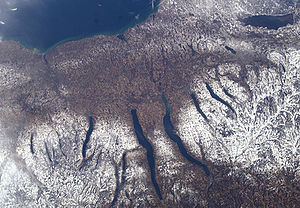
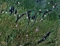
The Kawartha lakes of Ontario
Ontario
Ontario is a province of Canada, located in east-central Canada. It is Canada's most populous province and second largest in total area. It is home to the nation's most populous city, Toronto, and the nation's capital, Ottawa....
formed in the Late Wisconsinan
Wisconsinan glaciation
The Wisconsin Glacial Episode was the most recent major advance of the North American Laurentide ice sheet. Globally, this advance is known as the last glacial period. The Wisconsin glaciation extended from approximately 110,000 to 10,000 years ago, between the Eemian interglacial and the current...
glacial period. Ice melt from the Niagara Escarpment
Niagara Escarpment
The Niagara Escarpment is a long escarpment, or cuesta, in the United States and Canada that runs westward from New York State, through Ontario, Michigan, Wisconsin and Illinois...
flowed through tunnel valleys beneath the ice expanded to form a west-to-east passage between the main Laurentide ice sheet
Laurentide ice sheet
The Laurentide Ice Sheet was a massive sheet of ice that covered hundreds of thousands of square miles, including most of Canada and a large portion of the northern United States, multiple times during Quaternary glacial epochs. It last covered most of northern North America between c. 95,000 and...
and a mass of ice in the Lake Ontario
Lake Ontario
Lake Ontario is one of the five Great Lakes of North America. It is bounded on the north and southwest by the Canadian province of Ontario, and on the south by the American state of New York. Ontario, Canada's most populous province, was named for the lake. In the Wyandot language, ontarío means...
basin.
Cedar Creek Canyon
Cedar Creek Canyon (Indiana)
Cedar Creek Canyon, also called simply Cedar Canyon, is a topographical feature located in Allen County, Indiana. It is a very straight, narrow gorge about deep that contains part of the lower segment of Cedar Creek, the largest tributary of the St. Joseph River...
is a tunnel valley located in Allen County, Indiana
Allen County, Indiana
As of the census of 2000, there were 331,849 people, 128,745 households, and 86,259 families residing in the county. The population density was 505 people per square mile . There were 138,905 housing units at an average density of 211 per square mile...
. It is a very straight, narrow gorge
Canyon
A canyon or gorge is a deep ravine between cliffs often carved from the landscape by a river. Rivers have a natural tendency to reach a baseline elevation, which is the same elevation as the body of water it will eventually drain into. This forms a canyon. Most canyons were formed by a process of...
about 50 to 100 ft (15.2 to 30.5 ) deep that contains part of the lower segment of Cedar Creek
Cedar Creek (Indiana)
Called Mes-kwah-wa-se-pe or "old redwood creek" by Native Americans, Cedar Creek is the largest tributary of the St. Joseph River, draining in northeastern Indiana. It is long, rising in northwestern DeKalb County and joining the St...
, the largest tributary
Tributary
A tributary or affluent is a stream or river that flows into a main stem river or a lake. A tributary does not flow directly into a sea or ocean...
of the St. Joseph River
St. Joseph River (Maumee River)
The St. Joseph River is an tributary of the Maumee River in northwestern Ohio, and northeastern Indiana in the United States, with headwater tributaries rising in southern Michigan. It drains a primarily rural farming region in the watershed of Lake Erie. It shares its name with the St...
.
In the Laurentian Channel
Laurentian Channel
The Laurentian Channel is a submarine valley in eastern Canada.The channel is of glacial origin and is the submerged valley of the historic St. Lawrence River, running 1400 km from a sharp escarpment downstream from the confluence of the St. Lawrence with the Saguenay River, past Anticosti Island...
offshore eastern Canada, numerous tunnel valleys have been identified originating from the submerged valley of the St. Lawrence River, which is also of glacial origin. Seismic reflection profiles of the fill of tunnel valleys suggest that they are of various ages, with the youngest dating from shortly after the Late Glacial Maximum. They result from erosion by sub-glacial water crossing the eastern Scotian Shelf off Nova Scotia
Nova Scotia
Nova Scotia is one of Canada's three Maritime provinces and is the most populous province in Atlantic Canada. The name of the province is Latin for "New Scotland," but "Nova Scotia" is the recognized, English-language name of the province. The provincial capital is Halifax. Nova Scotia is the...
. They originate from the Laurentian Channel south of the Cabot Strait
Cabot Strait
Cabot Strait is a strait in eastern Canada approximately 110 kilometres wide between Cape Ray, Newfoundland and Cape North, Cape Breton Island. It is the widest of the three outlets for the Gulf of Saint Lawrence into the Atlantic Ocean, the others being the Strait of Belle Isle and Strait of Canso...
. Additionally, seismic profiles show deeply buried post-Miocene
Miocene
The Miocene is a geological epoch of the Neogene Period and extends from about . The Miocene was named by Sir Charles Lyell. Its name comes from the Greek words and and means "less recent" because it has 18% fewer modern sea invertebrates than the Pliocene. The Miocene follows the Oligocene...
channels, some of which lie 1100 m (3,608.9 ft) below modern sea level, cutting across the eastern part of the outer Laurentian Channel which have also tentatively been determined to be tunnel valleys. Seismic profiles have also mapped large tunnel valleys on Banquereau Bank and Sable Island Bank
Sable Island
Sable Island is a small Canadian island situated 300 km southeast of mainland Nova Scotia in the Atlantic Ocean. The island is a year-round home to approximately five people...
.
South America
The Perito Moreno GlacierPerito Moreno Glacier
The Perito Moreno Glacier is a glacier located in the Los Glaciares National Park in the south west of Santa Cruz province, Argentina. It is one of the most important tourist attractions in the Argentine Patagonia....
is located in the southern Southern Patagonian Ice Field
Southern Patagonian Ice Field
The Southern Patagonian Ice Field , located at the Southern Patagonic Andes between Argentina and Chile, is the second largest contiguous extrapolar extent of ice in the world...
, terminating in Lake Argentino
Lake Argentino
Lago Argentino is a lake in the Patagonian , at . It is the biggest freshwater lake in Argentina, with a surface area of . It has an average depth of , and a maximum depth of ....
at 50°30′S 73°6′W. It divides Lake Argentino into the Los Témpanos channel, and the Rico branch, blocking the channel and forming an ice dam. Lake Argentino periodically breaks through in outburst floods with drainage initially through a tunnel with subsequent roof collapse to form an open channel.
Temporal distribution
There have been five known ice ageIce age
An ice age or, more precisely, glacial age, is a generic geological period of long-term reduction in the temperature of the Earth's surface and atmosphere, resulting in the presence or expansion of continental ice sheets, polar ice sheets and alpine glaciers...
s in the Earth's history; the Earth is experiencing the Quaternary Ice Age
Quaternary glaciation
Quaternary glaciation, also known as the Pleistocene glaciation, the current ice age or simply the ice age, refers to the period of the last few million years in which permanent ice sheets were established in Antarctica and perhaps Greenland, and fluctuating ice sheets have occurred elsewhere...
during the present time.
| Name | Period (Ma) | Period | Era | Tunnel valleys and tunnel valley formation extensively observed |
|---|---|---|---|---|
| Quaternary Quaternary glaciation Quaternary glaciation, also known as the Pleistocene glaciation, the current ice age or simply the ice age, refers to the period of the last few million years in which permanent ice sheets were established in Antarctica and perhaps Greenland, and fluctuating ice sheets have occurred elsewhere... |
2.58 - Present | Neogene Neogene The Neogene is a geologic period and system in the International Commission on Stratigraphy Geologic Timescale starting 23.03 ± 0.05 million years ago and ending 2.588 million years ago... |
Cenozoic Cenozoic The Cenozoic era is the current and most recent of the three Phanerozoic geological eras and covers the period from 65.5 mya to the present. The era began in the wake of the Cretaceous–Tertiary extinction event at the end of the Cretaceous that saw the demise of the last non-avian dinosaurs and... |
Tunnel valleys formation has been reported in northern Asia, Europe, North America, and Antarctica |
| Karoo Karoo Ice Age The Karoo Ice Age from 360–260 Ma was the second major ice age of the Phanerozoic Eon. It is named after the glacial tills found in the Karoo region of South Africa where evidence for this ice age was first clearly identified.... |
360 - 260 | Carboniferous Carboniferous The Carboniferous is a geologic period and system that extends from the end of the Devonian Period, about 359.2 ± 2.5 Mya , to the beginning of the Permian Period, about 299.0 ± 0.8 Mya . The name is derived from the Latin word for coal, carbo. Carboniferous means "coal-bearing"... and Permian Permian The PermianThe term "Permian" was introduced into geology in 1841 by Sir Sir R. I. Murchison, president of the Geological Society of London, who identified typical strata in extensive Russian explorations undertaken with Edouard de Verneuil; Murchison asserted in 1841 that he named his "Permian... |
Paleozoic Paleozoic The Paleozoic era is the earliest of three geologic eras of the Phanerozoic eon, spanning from roughly... |
Tunnel valleys has been reported in the Carboniferous–Permian glacial record of Australia and of South Africa. |
| Andean-Saharan | 450 - 420 | Ordovician Ordovician The Ordovician is a geologic period and system, the second of six of the Paleozoic Era, and covers the time between 488.3±1.7 to 443.7±1.5 million years ago . It follows the Cambrian Period and is followed by the Silurian Period... and Silurian Silurian The Silurian is a geologic period and system that extends from the end of the Ordovician Period, about 443.7 ± 1.5 Mya , to the beginning of the Devonian Period, about 416.0 ± 2.8 Mya . As with other geologic periods, the rock beds that define the period's start and end are well identified, but the... |
Paleozoic Paleozoic The Paleozoic era is the earliest of three geologic eras of the Phanerozoic eon, spanning from roughly... |
Tunnel valleys have been reported in Jordan, Saudi Arabia, Mauritania Mauritania Mauritania is a country in the Maghreb and West Africa. It is bordered by the Atlantic Ocean in the west, by Western Sahara in the north, by Algeria in the northeast, by Mali in the east and southeast, and by Senegal in the southwest... , Mali Mali Mali , officially the Republic of Mali , is a landlocked country in Western Africa. Mali borders Algeria on the north, Niger on the east, Burkina Faso and the Côte d'Ivoire on the south, Guinea on the south-west, and Senegal and Mauritania on the west. Its size is just over 1,240,000 km² with... , Morocco Morocco Morocco , officially the Kingdom of Morocco , is a country located in North Africa. It has a population of more than 32 million and an area of 710,850 km², and also primarily administers the disputed region of the Western Sahara... , Algeria Algeria Algeria , officially the People's Democratic Republic of Algeria , also formally referred to as the Democratic and Popular Republic of Algeria, is a country in the Maghreb region of Northwest Africa with Algiers as its capital.In terms of land area, it is the largest country in Africa and the Arab... , Libya, Tunisia Tunisia Tunisia , officially the Tunisian RepublicThe long name of Tunisia in other languages used in the country is: , is the northernmost country in Africa. It is a Maghreb country and is bordered by Algeria to the west, Libya to the southeast, and the Mediterranean Sea to the north and east. Its area... , Niger Niger Niger , officially named the Republic of Niger, is a landlocked country in Western Africa, named after the Niger River. It borders Nigeria and Benin to the south, Burkina Faso and Mali to the west, Algeria and Libya to the north and Chad to the east... , Chad Chad Chad , officially known as the Republic of Chad, is a landlocked country in Central Africa. It is bordered by Libya to the north, Sudan to the east, the Central African Republic to the south, Cameroon and Nigeria to the southwest, and Niger to the west... , and Sudan Sudan Sudan , officially the Republic of the Sudan , is a country in North Africa, sometimes considered part of the Middle East politically. It is bordered by Egypt to the north, the Red Sea to the northeast, Eritrea and Ethiopia to the east, South Sudan to the south, the Central African Republic to the... . |
| Cryogenian Cryogenian The Cryogenian is a geologic period that lasted from . It forms the second geologic period of the Neoproterozoic Era, preceded by the Tonian Period and followed by the Ediacaran... (or Sturtian-Varangian) |
800 - 635 | Cryogenian Cryogenian The Cryogenian is a geologic period that lasted from . It forms the second geologic period of the Neoproterozoic Era, preceded by the Tonian Period and followed by the Ediacaran... |
Neoproterozoic Neoproterozoic The Neoproterozoic Era is the unit of geologic time from 1,000 to 542.0 ± 1.0 million years ago. The terminal Era of the formal Proterozoic Eon , it is further subdivided into the Tonian, Cryogenian, and Ediacaran Periods... |
Tunnel valleys have been reported in the Cryogenian strata of Oman and Mauritania. |
| Huronian | 2100–2400 | Siderian Siderian The Siderian is the first geologic period in the Paleoproterozoic Era and lasted from 2500 Mya to 2300 Mya . Instead of being based on stratigraphy, these dates are defined chronometrically.... and Rhyacian |
Paleoproterozoic Paleoproterozoic The Paleoproterozoic is the first of the three sub-divisions of the Proterozoic occurring between . This is when the continents first stabilized... |
See also
- Moulin (geology)Moulin (geology)A moulin or glacier mill is a roughly circular, vertical to nearly vertical well-like shaft within the a glacier through which water enters it from the surface. The term is derived from the French word for mill....
- Snake coils (geology)Snake coils (geology)Snake coils is a descriptive term used by physical geologist and glaciologists to describe the "snake coil"-like shape that occurs along certain ablation lines. Essentially miniature tunnel valleys, the peculiar natural shapes were first described by French Geologist Jean-Jerome Peytavi in 1973...
- http://ru.wikipedia.org/w/index.php?title=%D0%9B%D0%B5%D0%B4%D0%BE%D1%91%D0%BC&stable=0#.D0.A1.D0.BC._.D1.82.D0.B0.D0.BA.D0.B6.D0.B5 Ледоём (ru) (Icebody)