
Tsirang District
Encyclopedia
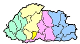
Tsirang District is one of the 20 dzongkhag
s (districts) of Bhutan
. The administrative center of the district is Damphu
Tsirang is noted for its gentle slopes and mild climates. The dzongkhag is also noted for its rich biodiversity, however it is one of the few dzongkhags without a protected area. One of Bhutan's longest rivers, the Punatsang Chhu or Sankosh river flows through the district. It is the main districts where the Lhotshampa
reside.
, spoken by the heterogeneous Lhotshampa
. In the north, Dzongkha, the national language, is also spoken.
s:
The northernmost reaches of Tsirang (Pungtenchhu, Sergithang Gewog
s) lie within Jigme Singye Wangchuck National Park
, one of the protected areas of Bhutan.
Dzongkhag
A dzongkhag is an administrative and judicial district of Bhutan. The twenty dzongkhags of Bhutan are further divided into 205 gewogs. Some larger dzongkhags have one or more of an intermediate judicial division, known as dungkhags , which themselves comprise two or more gewogs...
s (districts) of Bhutan
Bhutan
Bhutan , officially the Kingdom of Bhutan, is a landlocked state in South Asia, located at the eastern end of the Himalayas and bordered to the south, east and west by the Republic of India and to the north by the People's Republic of China...
. The administrative center of the district is Damphu
Damphu, Tsirang
Damphu is the administrative headquarters and capital of Tsirang District, Bhutan. It is located on the north-south highway running from Wangdue Phodrang to Sarpang and Gelephu on the border with India. It contains the Tsirang Dzong....
Tsirang is noted for its gentle slopes and mild climates. The dzongkhag is also noted for its rich biodiversity, however it is one of the few dzongkhags without a protected area. One of Bhutan's longest rivers, the Punatsang Chhu or Sankosh river flows through the district. It is the main districts where the Lhotshampa
Lhotshampa
Lhotshampa, or Lhotsampa, means "southerners" in Dzongkha, the national language of Bhutan. The term refers to the heterogeneous ethnic Nepalese population of Bhutan.-History:...
reside.
Languages
The dominant language in Tsirang is NepaliNepali language
Nepali or Nepalese is a language in the Indo-Aryan branch of the Indo-European language family.It is the official language and de facto lingua franca of Nepal and is also spoken in Bhutan, parts of India and parts of Myanmar...
, spoken by the heterogeneous Lhotshampa
Lhotshampa
Lhotshampa, or Lhotsampa, means "southerners" in Dzongkha, the national language of Bhutan. The term refers to the heterogeneous ethnic Nepalese population of Bhutan.-History:...
. In the north, Dzongkha, the national language, is also spoken.
Geography
Tsirang is divided into twelve gewogGewog
A gewog, or geog refers to a group of villages in Bhutan. Gewogs form a geographic administrative unit below dzongkhag districts , and above thromde municipalities. Bhutan comprises 205 gewogs, which average 230 km² in area...
s:
- Barshong GewogBarshong GewogBarshong Gewog is a gewog of Tsirang District, Bhutan....
- Dunglegang GewogDunglegang GewogDunglegang Gewog is a gewog of Tsirang District, Bhutan....
- Goseling GewogGoseling GewogGosarling Gewog is a gewog of Tsirang District, Bhutan. Its old name was Goseling....
- Kikhorthang GewogKikhorthang GewogKikhorthang Gewog is a gewog of Tsirang District, Bhutan....
- Mendrelgang GewogMendrelgang GewogMendrelgang Gewog is a gewog of Tsirang District, Bhutan....
- Patale GewogPatale GewogPatshaling Gewog is a gewog of Tsirang District, Bhutan. It was formerly called Patale....
- Phutenchhu GewogPhutenchhu GewogPhuntenchu Gewog is a gewog of Tsirang District, Bhutan....
- Rangthangling GewogRangthangling GewogRangthangling Gewog is a gewog of Tsirang District, Bhutan....
- Semjong GewogSemjong GewogSemjong Gewog is a gewog of Tsirang District, Bhutan....
- Sergithang GewogSergithang GewogSergithang Gewog is a gewog of Tsirang District, Bhutan....
- Tsholingkhar GewogTsholingkhar GewogTsholingkhar Gewog is a gewog of Tsirang District, Bhutan....
- Tsirangtoe GewogTsirangtoe GewogTsirangtoe Gewog is a gewog of Tsirang District, Bhutan....
The northernmost reaches of Tsirang (Pungtenchhu, Sergithang Gewog
Sergithang Gewog
Sergithang Gewog is a gewog of Tsirang District, Bhutan....
s) lie within Jigme Singye Wangchuck National Park
Jigme Singye Wangchuck National Park
Jigme Singye Wangchuck National Park covers an area of in central Bhutan. The Park occupies most of Trongsa District, as well as parts of Sarpang, Tsirang, Wangdue Phodrang, and Zhemgang Districts. Jigme Singye abuts Royal Manas National Park to the southeast...
, one of the protected areas of Bhutan.