
Truro, Massachusetts
Encyclopedia
Truro is a town
in Barnstable County
, Massachusetts
, United States
, comprising two villages: Truro and North Truro. Located two hours outside Boston
, it is a summer vacation community just south of the northern tip of Cape Cod
, in an area known as the "Outer Cape". English colonists named it after Truro
in Cornwall
, United Kingdom
.
The historic Wampanoag Native American
people called the area Pamet or Payomet. Their language was part of the large Algonquian
family. This name was adopted for the Pamet River
and the harbor area around the town center known as the Pamet Roads. The population of Truro was 2,087 at the 2000 census.
Over half of the land area of the town is part of the Cape Cod National Seashore
, established in 1961 by President John F. Kennedy
, and administered by the U.S. National Park Service
.
for thousands of years before Europeans arrived. At the time of English colonization, the Wampanoag Kakopee tribe was the dominant one on Cape Cod, numbering about 7,000 by early accounts. They used the cape and its waters for hunting, fishing and gathering shellfish. They also cultivated maize
to supplement their diets and to store for winter eating.
The English Pilgrims stopped in Truro and Provincetown
in 1620 as their original choice for a landing before later deciding the area to be unsuitable. While there, they discovered fresh water and corn stored by the Kakopee. Historians debate the accuracy of the account about the latter discovery, but in popular lore it led to the place being called Corn Hill.
Truro was settled by English immigrant colonists in the 1690s as the northernmost portion of the town of Eastham
. The town was officially separated and incorporated in 1709. Fishing, whaling
and shipbuilding
made up the town's early industry. These industries had to shift to other locations as the harsh tides of the Lower Cape began decimating the town's main port in the 1850s. In the late 19th and early 20th century, Cape Cod was a popular location for artists because of its light.
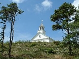
Today, Truro is one of the more exclusive towns on the Cape, noted for its affluent residences and the rolling hills and dunes along the coast. Truro is the site of the Cape Cod Highland Lighthouse (also known as the Cape Cod Light), the first lighthouse on Cape Cod. The first building was erected in 1797; the current lighthouse was built in 1857. The entire 430-ton light was moved about 1/10 of a mile inland in 1996. By then, because of erosion, its original site was just ten yards from the edge of the shore cliffs.
The old town cemetery was the location of the murders in 1969 of Susan Perry, Patricia Walsh, Sydney Monzon and Mary Anna Wysocki by Tony Costa
.
, the town has a total area of 26.3 square miles (68.1 km²), of which, 21 square miles (54.4 km²) of it is land and 5.3 square miles (13.7 km²) of it (20.02%) is water. Truro is located just south and east of the "tip" of Cape Cod, and is bordered by Provincetown to the northwest, the Atlantic Ocean
to the north and east, Wellfleet
to the south, and Cape Cod Bay
to the west. The town is thirty-eight miles by road to Barnstable
, fifty miles from the Sagamore Bridge
and 105 miles by road from Boston.
The topography generally slopes downward from the Atlantic to Cape Cod Bay, and from south to north. There are several small ponds throughout town, all of which combined are smaller than the Pilgrim Lake, just east of the Provincetown town line, and just south of the sand dunes which make up most of the northern tip of the Cape. Pamet Harbor, a small inlet, is in the southern half of the town on the Cape Cod Bay side, and leads to the Pamet River
. Just south of the lighthouse is a Coast Guard radar station, equipped with a Doppler radar
tower, close to the nearby Jenny Lind
Tower.
of 2000, there were 2,087 people, 907 households, and 515 families residing in the town. The population density
was 99.1 people per square mile (38.3/km²). There were 2,551 housing units at an average density of 121.2 per square mile (46.8/km²). The racial makeup of the town was 95.11% White, 1.87% African American, 0.43% Native American, 0.38% Asian, 0.10% Pacific Islander, 0.77% from other races
, and 1.34% from two or more races. Hispanic or Latino of any race were 1.15% of the population.
There were 907 households out of which 21.2% had children under the age of 18 living with them, 46.3% were married couples
living together, 7.9% had a female householder with no husband present, and 43.2% were non-families. 32.0% of all households were made up of individuals and 12.5% had someone living alone who was 65 years of age or older. The average household size was 2.18 and the average family size was 2.76.
In the town the population was spread out with 17.4% under the age of 18, 4.1% from 18 to 24, 27.2% from 25 to 44, 34.4% from 45 to 64, and 17.0% who were 65 years of age or older. The median age was 46 years. For every 100 females there were 86.5 males. For every 100 females age 18 and over, there were 84.7 males.
The median income for a household in the town was $42,981, and the median income for a family was $51,389. Males had a median income of $37,208 versus $30,435 for females. The per capita income
for the town was $22,608. About 4.8% of families and 11.2% of the population were below the poverty line, including 8.5% of those under age 18 and 10.3% of those age 65 or over.
as a part of the Fourth Barnstable district, which includes (with the exception of Brewster) all the towns east and north of Harwich on the Cape. The town is represented in the Massachusetts Senate
as a part of the Cape and Islands District, which includes all of Cape Cod, Martha's Vineyard and Nantucket except the towns of Bourne, Falmouth, Sandwich and a portion of Barnstable. Truro is patrolled by the Second (Yarmouth) Barracks of Troop D of the Massachusetts State Police
.
On the national level, Truro is a part of Massachusetts's 10th congressional district
, and is currently represented by Bill Delahunt
. Following the death of Ted Kennedy
, the state's senior (Class I) member of the United States Senate
is John Kerry
(re-elected in 2008); the junior (Class II) senate seat is held by Scott Brown.
Like most small incorporated communities in New England, Truro uses an open town meeting
form of government, led by a Town Moderator and a Board of Selectmen
. The town has its own police and fire departments, headquartered on Route 6 just south of the Route 6A split. The town has two post offices: one for Truro proper (02666), located on Truro Center Road, and one for the village of North Truro (02652), located on Shore Road (MA Route 6A). The town's Public Library is located between the two routes in a secluded spot, leading to the slogan, "The Library In The Woods."
, some Truro residents have made considerable, and often successful, efforts to prevent development projects which they perceive to threaten the town's character. They opposed a proposed Stop & Shop
grocery store and the WTUR/WCDJ/WGTX communication tower. The latter project was finally built in 2007, almost 20 years after the station was first licensed.
in Harwich
, free of charge.
is the main route through town, passing through the town from south to north on its way to Provincetown. The "second" portion of the Cape's Route 6A
begins in the town, tracing the original path of Route 6, and passing into Provincetown barely 250 feet south of the main route. There is no rail or air service in the town; the nearest regional airport is located in neighboring Provincetown. The nearest national and international air service can be found at Logan International Airport
in Boston.
New England town
The New England town is the basic unit of local government in each of the six New England states. Without a direct counterpart in most other U.S. states, New England towns are conceptually similar to civil townships in other states, but are incorporated, possessing powers like cities in other...
in Barnstable County
Barnstable County, Massachusetts
Barnstable County is a county located in the U.S. state of Massachusetts, consisting of Cape Cod and associated islands. As of the 2010 census, the population was 216,902...
, Massachusetts
Massachusetts
The Commonwealth of Massachusetts is a state in the New England region of the northeastern United States of America. It is bordered by Rhode Island and Connecticut to the south, New York to the west, and Vermont and New Hampshire to the north; at its east lies the Atlantic Ocean. As of the 2010...
, United States
United States
The United States of America is a federal constitutional republic comprising fifty states and a federal district...
, comprising two villages: Truro and North Truro. Located two hours outside Boston
Boston
Boston is the capital of and largest city in Massachusetts, and is one of the oldest cities in the United States. The largest city in New England, Boston is regarded as the unofficial "Capital of New England" for its economic and cultural impact on the entire New England region. The city proper had...
, it is a summer vacation community just south of the northern tip of Cape Cod
Cape Cod
Cape Cod, often referred to locally as simply the Cape, is a cape in the easternmost portion of the state of Massachusetts, in the Northeastern United States...
, in an area known as the "Outer Cape". English colonists named it after Truro
Truro
Truro is a city and civil parish in Cornwall, England, United Kingdom. The city is the centre for administration, leisure and retail in Cornwall, with a population recorded in the 2001 census of 17,431. Truro urban statistical area, which includes parts of surrounding parishes, has a 2001 census...
in Cornwall
Cornwall
Cornwall is a unitary authority and ceremonial county of England, within the United Kingdom. It is bordered to the north and west by the Celtic Sea, to the south by the English Channel, and to the east by the county of Devon, over the River Tamar. Cornwall has a population of , and covers an area of...
, United Kingdom
United Kingdom
The United Kingdom of Great Britain and Northern IrelandIn the United Kingdom and Dependencies, other languages have been officially recognised as legitimate autochthonous languages under the European Charter for Regional or Minority Languages...
.
The historic Wampanoag Native American
Indigenous peoples of the Americas
The indigenous peoples of the Americas are the pre-Columbian inhabitants of North and South America, their descendants and other ethnic groups who are identified with those peoples. Indigenous peoples are known in Canada as Aboriginal peoples, and in the United States as Native Americans...
people called the area Pamet or Payomet. Their language was part of the large Algonquian
Algonquian language
Algonquian language may refer to:* Algonquian languages, language sub-family indigenous to North America* Algonquin language, the particular Algonquian language spoken by certain First-Nations people of Canada...
family. This name was adopted for the Pamet River
Pamet River
The Pamet River is a river in Truro, Massachusetts on Cape Cod. It is named for the Paomet tribe.The river is primarily salt marsh, flows west nearly all the way across Cape Cod from its eastern beaches, and empties into Cape Cod Bay. It lies a few miles south of the Little Pamet River.The upper...
and the harbor area around the town center known as the Pamet Roads. The population of Truro was 2,087 at the 2000 census.
Over half of the land area of the town is part of the Cape Cod National Seashore
Cape Cod National Seashore
The Cape Cod National Seashore , created on August 7, 1961 by President John F. Kennedy, encompasses on Cape Cod, Massachusetts. It includes ponds, woods and beachfront of the Atlantic coastal pine barrens ecoregion...
, established in 1961 by President John F. Kennedy
John F. Kennedy
John Fitzgerald "Jack" Kennedy , often referred to by his initials JFK, was the 35th President of the United States, serving from 1961 until his assassination in 1963....
, and administered by the U.S. National Park Service
National Park Service
The National Park Service is the U.S. federal agency that manages all national parks, many national monuments, and other conservation and historical properties with various title designations...
.
History
Cape Cod was the territory of succeeding cultures of indigenous peoplesIndigenous peoples
Indigenous peoples are ethnic groups that are defined as indigenous according to one of the various definitions of the term, there is no universally accepted definition but most of which carry connotations of being the "original inhabitants" of a territory....
for thousands of years before Europeans arrived. At the time of English colonization, the Wampanoag Kakopee tribe was the dominant one on Cape Cod, numbering about 7,000 by early accounts. They used the cape and its waters for hunting, fishing and gathering shellfish. They also cultivated maize
Maize
Maize known in many English-speaking countries as corn or mielie/mealie, is a grain domesticated by indigenous peoples in Mesoamerica in prehistoric times. The leafy stalk produces ears which contain seeds called kernels. Though technically a grain, maize kernels are used in cooking as a vegetable...
to supplement their diets and to store for winter eating.
The English Pilgrims stopped in Truro and Provincetown
Provincetown, Massachusetts
Provincetown is a New England town located at the extreme tip of Cape Cod in Barnstable County, Massachusetts, United States. The population was 3,431 at the 2000 census, with an estimated 2007 population of 3,174...
in 1620 as their original choice for a landing before later deciding the area to be unsuitable. While there, they discovered fresh water and corn stored by the Kakopee. Historians debate the accuracy of the account about the latter discovery, but in popular lore it led to the place being called Corn Hill.
Truro was settled by English immigrant colonists in the 1690s as the northernmost portion of the town of Eastham
Eastham, Massachusetts
Eastham is a town in Barnstable County, Massachusetts, United States, Barnstable County being coextensive with Cape Cod. The population was 5,453 at the 2000 census....
. The town was officially separated and incorporated in 1709. Fishing, whaling
Whaling
Whaling is the hunting of whales mainly for meat and oil. Its earliest forms date to at least 3000 BC. Various coastal communities have long histories of sustenance whaling and harvesting beached whales...
and shipbuilding
Shipbuilding
Shipbuilding is the construction of ships and floating vessels. It normally takes place in a specialized facility known as a shipyard. Shipbuilders, also called shipwrights, follow a specialized occupation that traces its roots to before recorded history.Shipbuilding and ship repairs, both...
made up the town's early industry. These industries had to shift to other locations as the harsh tides of the Lower Cape began decimating the town's main port in the 1850s. In the late 19th and early 20th century, Cape Cod was a popular location for artists because of its light.
Today, Truro is one of the more exclusive towns on the Cape, noted for its affluent residences and the rolling hills and dunes along the coast. Truro is the site of the Cape Cod Highland Lighthouse (also known as the Cape Cod Light), the first lighthouse on Cape Cod. The first building was erected in 1797; the current lighthouse was built in 1857. The entire 430-ton light was moved about 1/10 of a mile inland in 1996. By then, because of erosion, its original site was just ten yards from the edge of the shore cliffs.
The old town cemetery was the location of the murders in 1969 of Susan Perry, Patricia Walsh, Sydney Monzon and Mary Anna Wysocki by Tony Costa
Tony Costa
Antone Charles "Tony" Costa was a Cape Cod, Massachusetts carpenter who achieved notoriety for committing murders in the town of Truro in 1969.-1969 murders:...
.
Geography
According to the United States Census BureauUnited States Census Bureau
The United States Census Bureau is the government agency that is responsible for the United States Census. It also gathers other national demographic and economic data...
, the town has a total area of 26.3 square miles (68.1 km²), of which, 21 square miles (54.4 km²) of it is land and 5.3 square miles (13.7 km²) of it (20.02%) is water. Truro is located just south and east of the "tip" of Cape Cod, and is bordered by Provincetown to the northwest, the Atlantic Ocean
Atlantic Ocean
The Atlantic Ocean is the second-largest of the world's oceanic divisions. With a total area of about , it covers approximately 20% of the Earth's surface and about 26% of its water surface area...
to the north and east, Wellfleet
Wellfleet, Massachusetts
Wellfleet is a New England town in Barnstable County, Massachusetts, United States. Located halfway between the "tip" and "elbow" of Cape Cod, Massachusetts, the town had a population of 2,749 at the 2000 census, which swells nearly sixfold during the summer...
to the south, and Cape Cod Bay
Cape Cod Bay
Cape Cod Bay is a large bay of the Atlantic Ocean adjacent to the U.S. state of Massachusetts. Measuring below a line drawn from Brant Rock in Marshfield to Race Point in Provincetown, Massachusetts, it is enclosed by Cape Cod to the south and east, and Plymouth County, Massachusetts, to the west....
to the west. The town is thirty-eight miles by road to Barnstable
Barnstable, Massachusetts
Barnstable is a city, referred to as the Town of Barnstable, in the U.S. state of Massachusetts and the county seat of Barnstable County. Barnstable is the largest community, both in land area and population, on Cape Cod. The town contains seven villages within its boundaries...
, fifty miles from the Sagamore Bridge
Sagamore Bridge
The Sagamore Bridge in Sagamore, Massachusetts carries U.S. Route 6 across the Cape Cod Canal, connecting Cape Cod with the rest of Massachusetts, USA....
and 105 miles by road from Boston.
The topography generally slopes downward from the Atlantic to Cape Cod Bay, and from south to north. There are several small ponds throughout town, all of which combined are smaller than the Pilgrim Lake, just east of the Provincetown town line, and just south of the sand dunes which make up most of the northern tip of the Cape. Pamet Harbor, a small inlet, is in the southern half of the town on the Cape Cod Bay side, and leads to the Pamet River
Pamet River
The Pamet River is a river in Truro, Massachusetts on Cape Cod. It is named for the Paomet tribe.The river is primarily salt marsh, flows west nearly all the way across Cape Cod from its eastern beaches, and empties into Cape Cod Bay. It lies a few miles south of the Little Pamet River.The upper...
. Just south of the lighthouse is a Coast Guard radar station, equipped with a Doppler radar
Doppler radar
A Doppler radar is a specialized radar that makes use of the Doppler effect to produce velocity data about objects at a distance. It does this by beaming a microwave signal towards a desired target and listening for its reflection, then analyzing how the frequency of the returned signal has been...
tower, close to the nearby Jenny Lind
Jenny Lind
Johanna Maria Lind , better known as Jenny Lind, was a Swedish opera singer, often known as the "Swedish Nightingale". One of the most highly regarded singers of the 19th century, she is known for her performances in soprano roles in opera in Sweden and across Europe, and for an extraordinarily...
Tower.
Demographics
As of the censusCensus
A census is the procedure of systematically acquiring and recording information about the members of a given population. It is a regularly occurring and official count of a particular population. The term is used mostly in connection with national population and housing censuses; other common...
of 2000, there were 2,087 people, 907 households, and 515 families residing in the town. The population density
Population density
Population density is a measurement of population per unit area or unit volume. It is frequently applied to living organisms, and particularly to humans...
was 99.1 people per square mile (38.3/km²). There were 2,551 housing units at an average density of 121.2 per square mile (46.8/km²). The racial makeup of the town was 95.11% White, 1.87% African American, 0.43% Native American, 0.38% Asian, 0.10% Pacific Islander, 0.77% from other races
Race (United States Census)
Race and ethnicity in the United States Census, as defined by the Federal Office of Management and Budget and the United States Census Bureau, are self-identification data items in which residents choose the race or races with which they most closely identify, and indicate whether or not they are...
, and 1.34% from two or more races. Hispanic or Latino of any race were 1.15% of the population.
There were 907 households out of which 21.2% had children under the age of 18 living with them, 46.3% were married couples
Marriage
Marriage is a social union or legal contract between people that creates kinship. It is an institution in which interpersonal relationships, usually intimate and sexual, are acknowledged in a variety of ways, depending on the culture or subculture in which it is found...
living together, 7.9% had a female householder with no husband present, and 43.2% were non-families. 32.0% of all households were made up of individuals and 12.5% had someone living alone who was 65 years of age or older. The average household size was 2.18 and the average family size was 2.76.
In the town the population was spread out with 17.4% under the age of 18, 4.1% from 18 to 24, 27.2% from 25 to 44, 34.4% from 45 to 64, and 17.0% who were 65 years of age or older. The median age was 46 years. For every 100 females there were 86.5 males. For every 100 females age 18 and over, there were 84.7 males.
The median income for a household in the town was $42,981, and the median income for a family was $51,389. Males had a median income of $37,208 versus $30,435 for females. The per capita income
Per capita income
Per capita income or income per person is a measure of mean income within an economic aggregate, such as a country or city. It is calculated by taking a measure of all sources of income in the aggregate and dividing it by the total population...
for the town was $22,608. About 4.8% of families and 11.2% of the population were below the poverty line, including 8.5% of those under age 18 and 10.3% of those age 65 or over.
Government
Truro is represented in the Massachusetts House of RepresentativesMassachusetts House of Representatives
The Massachusetts House of Representatives is the lower house of the Massachusetts General Court, the state legislature of the Commonwealth of Massachusetts. It is composed of 160 members elected from single-member electoral districts across the Commonwealth. Representatives serve two-year terms...
as a part of the Fourth Barnstable district, which includes (with the exception of Brewster) all the towns east and north of Harwich on the Cape. The town is represented in the Massachusetts Senate
Massachusetts Senate
The Massachusetts Senate is the upper house of the Massachusetts General Court, the bicameral state legislature of the Commonwealth of Massachusetts. The Senate comprises 40 elected members from 40 single-member senatorial districts in the state...
as a part of the Cape and Islands District, which includes all of Cape Cod, Martha's Vineyard and Nantucket except the towns of Bourne, Falmouth, Sandwich and a portion of Barnstable. Truro is patrolled by the Second (Yarmouth) Barracks of Troop D of the Massachusetts State Police
Massachusetts State Police
The Massachusetts State Police is an agency of the Commonwealth of Massachusetts' Executive Office of Public Safety and Security responsible for criminal law enforcement and traffic vehicle regulation across the state...
.
On the national level, Truro is a part of Massachusetts's 10th congressional district
Massachusetts's 10th congressional district
Massachusetts's 10th congressional district is a political constituency that includes parts of the South Shore of Massachusetts, and all of Cape Cod and the islands. With a population of 635,901 and a land area of , it is the most populous of Massachusetts's ten congressional districts and the...
, and is currently represented by Bill Delahunt
Bill Delahunt
William D. Delahunt is a former U.S. Representative for , serving from 1997 to 2011. He is a member of the Democratic Party. Delahunt did not seek re-election in 2010, and left Congress in January 2011. He was replaced by Norfolk County District Attorney Bill Keating...
. Following the death of Ted Kennedy
Ted Kennedy
Edward Moore "Ted" Kennedy was a United States Senator from Massachusetts and a member of the Democratic Party. Serving almost 47 years, he was the second most senior member of the Senate when he died and is the fourth-longest-serving senator in United States history...
, the state's senior (Class I) member of the United States Senate
United States Senate
The United States Senate is the upper house of the bicameral legislature of the United States, and together with the United States House of Representatives comprises the United States Congress. The composition and powers of the Senate are established in Article One of the U.S. Constitution. Each...
is John Kerry
John Kerry
John Forbes Kerry is the senior United States Senator from Massachusetts, the 10th most senior U.S. Senator and chairman of the Senate Foreign Relations Committee. He was the presidential nominee of the Democratic Party in the 2004 presidential election, but lost to former President George W...
(re-elected in 2008); the junior (Class II) senate seat is held by Scott Brown.
Like most small incorporated communities in New England, Truro uses an open town meeting
Open town meeting
An open town meeting is a form of town meeting in which all registered voters of a town may vote . This form of government is typical of smaller municipalities in the New England region of the United States....
form of government, led by a Town Moderator and a Board of Selectmen
Board of selectmen
The board of selectmen is commonly the executive arm of the government of New England towns in the United States. The board typically consists of three or five members, with or without staggered terms.-History:...
. The town has its own police and fire departments, headquartered on Route 6 just south of the Route 6A split. The town has two post offices: one for Truro proper (02666), located on Truro Center Road, and one for the village of North Truro (02652), located on Shore Road (MA Route 6A). The town's Public Library is located between the two routes in a secluded spot, leading to the slogan, "The Library In The Woods."
Opposition to development
Through town meeting, as well as the town's Planning Board and the Cape Cod CommissionCape Cod Commission
The Cape Cod Commission is a regional planning authority created in 1990 by an Act of the Massachusetts General Court and confirmed by a majority of Barnstable County voters....
, some Truro residents have made considerable, and often successful, efforts to prevent development projects which they perceive to threaten the town's character. They opposed a proposed Stop & Shop
Stop & Shop
The Stop & Shop Supermarket Company is a chain of supermarkets located mostly in the northeastern United States. Its main rivals are Shaw's Star Market and Hannaford in New England, while ShopRite and the A&P family of supermarkets are its main competition in New York and New Jersey.- History :Stop...
grocery store and the WTUR/WCDJ/WGTX communication tower. The latter project was finally built in 2007, almost 20 years after the station was first licensed.
Education
Truro operates the Truro Central School for students from kindergarten through sixth grade. The town does not have its own middle or high school; a tuition agreement is in place with the Provincetown and Nauset Regional school districts. There are no private schools anywhere on the lower Cape; high school students additionally have the option of attending the Cape Cod Regional Technical High SchoolCape Cod Regional Technical High School
Cape Cod Regional Technical High School, also known as Cape Tech and Lower Cape Tech and sometimes abbreviated as CCT, is a public vocational and technical high school located in Harwich, Massachusetts....
in Harwich
Harwich, Massachusetts
Harwich is a New England town on Cape Cod, in Barnstable County in the state of Massachusetts in the United States. Barnstable County is coextensive with Cape Cod. The town is a popular vacation spot, located near the Cape Cod National Seashore. Harwich's beaches are on "the Sound side" of Cape...
, free of charge.
Transportation
U.S. Route 6U.S. Route 6
U.S. Route 6 , also called the Grand Army of the Republic Highway, a name that honors an American Civil War veterans association, is a main route of the U.S. Highway system, running east-northeast from Bishop, California to Provincetown, Massachusetts. Until 1964, it continued south from Bishop to...
is the main route through town, passing through the town from south to north on its way to Provincetown. The "second" portion of the Cape's Route 6A
Route 6A (Massachusetts)
Route 6A is the name for parts of former U.S. Route 6 on Cape Cod. Most of "6A", as the locals call it, is also known as the Old King's Highway...
begins in the town, tracing the original path of Route 6, and passing into Provincetown barely 250 feet south of the main route. There is no rail or air service in the town; the nearest regional airport is located in neighboring Provincetown. The nearest national and international air service can be found at Logan International Airport
Logan International Airport
General Edward Lawrence Logan International Airport is located in the East Boston neighborhood of Boston, Massachusetts . It covers , has six runways, and employs an estimated 16,000 people. It is the 19th busiest airport in the United States.Boston serves as a focus city for JetBlue Airways...
in Boston.
Truro in film
- The first film in the Men In Black series displayed Truro on a satelliteSatelliteIn the context of spaceflight, a satellite is an object which has been placed into orbit by human endeavour. Such objects are sometimes called artificial satellites to distinguish them from natural satellites such as the Moon....
map, but the map zoomed in on FalmouthFalmouth, MassachusettsFalmouth is a town in Barnstable County, Massachusetts, United States; Barnstable County is coextensive with Cape Cod. The population was 31,531 at the 2010 census....
, a town at the opposite end of Cape Cod. In Men in Black IIMen in Black IIMen in Black II is a 2002 science fiction action comedy starring Will Smith and Tommy Lee Jones. The film also stars Lara Flynn Boyle, Johnny Knoxville, Rosario Dawson and Rip Torn...
(2002) Truro was the town to which Tommy Lee Jones' character "Agent K" retired and became a postal worker. The post office was portrayed as a solitary building in the middle of nowhere. In contrast, Truro's post office is in the heart of "downtown" Truro, which is also the location of a small convenience store and a few shops.