
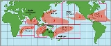
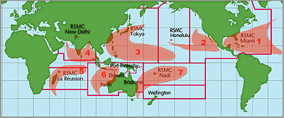
Tropical cyclone basins
Encyclopedia
Tropical cyclone
A tropical cyclone is a storm system characterized by a large low-pressure center and numerous thunderstorms that produce strong winds and heavy rain. Tropical cyclones strengthen when water evaporated from the ocean is released as the saturated air rises, resulting in condensation of water vapor...
formation are divided into seven basins. These include the north Atlantic Ocean
Atlantic Ocean
The Atlantic Ocean is the second-largest of the world's oceanic divisions. With a total area of about , it covers approximately 20% of the Earth's surface and about 26% of its water surface area...
, the eastern and western parts of the northern Pacific Ocean
Pacific Ocean
The Pacific Ocean is the largest of the Earth's oceanic divisions. It extends from the Arctic in the north to the Southern Ocean in the south, bounded by Asia and Australia in the west, and the Americas in the east.At 165.2 million square kilometres in area, this largest division of the World...
, the southwestern Pacific, the southwestern and southeastern Indian Ocean
Indian Ocean
The Indian Ocean is the third largest of the world's oceanic divisions, covering approximately 20% of the water on the Earth's surface. It is bounded on the north by the Indian Subcontinent and Arabian Peninsula ; on the west by eastern Africa; on the east by Indochina, the Sunda Islands, and...
s, and the northern Indian Ocean. The western Pacific is the most active and the north Indian the least active. An average of 86 tropical cyclones of tropical storm intensity form annually worldwide, with 47 reaching hurricane/typhoon strength, and 20 becoming intense tropical cyclones (at least of Category 3
Saffir-Simpson Hurricane Scale
The Saffir–Simpson Hurricane Scale , or the Saffir–Simpson Hurricane Wind Scale , classifies hurricanes — Western Hemisphere tropical cyclones that exceed the intensities of tropical depressions and tropical storms — into five categories distinguished by the intensities of their sustained winds...
intensity).
Northern Atlantic Ocean

This region includes the North Atlantic Ocean
Atlantic Ocean
The Atlantic Ocean is the second-largest of the world's oceanic divisions. With a total area of about , it covers approximately 20% of the Earth's surface and about 26% of its water surface area...
, the Caribbean Sea
Caribbean Sea
The Caribbean Sea is a sea of the Atlantic Ocean located in the tropics of the Western hemisphere. It is bounded by Mexico and Central America to the west and southwest, to the north by the Greater Antilles, and to the east by the Lesser Antilles....
, and the Gulf of Mexico
Gulf of Mexico
The Gulf of Mexico is a partially landlocked ocean basin largely surrounded by the North American continent and the island of Cuba. It is bounded on the northeast, north and northwest by the Gulf Coast of the United States, on the southwest and south by Mexico, and on the southeast by Cuba. In...
. Tropical cyclone formation here varies widely from year to year, ranging from one to over twenty-five per year. Most Atlantic tropical storms
Tropical cyclone
A tropical cyclone is a storm system characterized by a large low-pressure center and numerous thunderstorms that produce strong winds and heavy rain. Tropical cyclones strengthen when water evaporated from the ocean is released as the saturated air rises, resulting in condensation of water vapor...
and hurricanes form between June 1 and November 30. The United States
United States
The United States of America is a federal constitutional republic comprising fifty states and a federal district...
National Hurricane Center
National Hurricane Center
The National Hurricane Center , located at Florida International University in Miami, Florida, is the division of the National Weather Service responsible for tracking and predicting weather systems within the tropics between the Prime Meridian and the 140th meridian west poleward to the 30th...
monitors the basin and issues reports, watches and warnings about tropical weather systems for the Atlantic Basin as one of the Regional Specialized Meteorological Centre
Regional Specialized Meteorological Centre
A Regional Specialized Meteorological Centre is responsible for the distribution of information, advisories, and warnings regarding the specific program they have a part of, agreed by consensus at the World Meteorological Organization as part of the World Weather Watch.-Tropical...
s for tropical cyclone
Tropical cyclone
A tropical cyclone is a storm system characterized by a large low-pressure center and numerous thunderstorms that produce strong winds and heavy rain. Tropical cyclones strengthen when water evaporated from the ocean is released as the saturated air rises, resulting in condensation of water vapor...
s as defined by the World Meteorological Organization
World Meteorological Organization
The World Meteorological Organization is an intergovernmental organization with a membership of 189 Member States and Territories. It originated from the International Meteorological Organization , which was founded in 1873...
. On average, 11 named storms (of tropical storm or higher strength) occur each season, with an average of 6 becoming hurricanes and 2 becoming major hurricanes. The climatological
Climatology
Climatology is the study of climate, scientifically defined as weather conditions averaged over a period of time, and is a branch of the atmospheric sciences...
peak of activity is around September 10 each season.
The United States
United States
The United States of America is a federal constitutional republic comprising fifty states and a federal district...
Atlantic coast, Mexico
Mexico
The United Mexican States , commonly known as Mexico , is a federal constitutional republic in North America. It is bordered on the north by the United States; on the south and west by the Pacific Ocean; on the southeast by Guatemala, Belize, and the Caribbean Sea; and on the east by the Gulf of...
, Central America
Central America
Central America is the central geographic region of the Americas. It is the southernmost, isthmian portion of the North American continent, which connects with South America on the southeast. When considered part of the unified continental model, it is considered a subcontinent...
, the Caribbean Islands, and Bermuda
Bermuda
Bermuda is a British overseas territory in the North Atlantic Ocean. Located off the east coast of the United States, its nearest landmass is Cape Hatteras, North Carolina, about to the west-northwest. It is about south of Halifax, Nova Scotia, Canada, and northeast of Miami, Florida...
are frequently affected by storms in this basin. Venezuela, the south-east of Canada and Atlantic Macaronesian islands
Macaronesia
Macaronesia is a modern collective name for several groups of islands in the North Atlantic Ocean near Europe and North Africa belonging to three countries: Portugal, Spain, and Cape Verde...
also are occasionally affected. Many of the more intense Atlantic storms are Cape Verde-type hurricane
Cape Verde-type hurricane
A Cape Verde-type hurricane is an Atlantic hurricane that develops near the Cape Verde islands, off the west coast of Africa. The average hurricane season has about two Cape Verde-type hurricanes, which are usually the largest and most intense storms of the season because they often have plenty of...
s, which form off the west coast of Africa
Africa
Africa is the world's second largest and second most populous continent, after Asia. At about 30.2 million km² including adjacent islands, it covers 6% of the Earth's total surface area and 20.4% of the total land area...
near the Cape Verde
Cape Verde
The Republic of Cape Verde is an island country, spanning an archipelago of 10 islands located in the central Atlantic Ocean, 570 kilometres off the coast of Western Africa...
islands. Occasionally, a hurricane that evolves into an extratropical cyclone
Extratropical cyclone
Extratropical cyclones, sometimes called mid-latitude cyclones or wave cyclones, are a group of cyclones defined as synoptic scale low pressure weather systems that occur in the middle latitudes of the Earth having neither tropical nor polar characteristics, and are connected with fronts and...
can reach western Europe
Europe
Europe is, by convention, one of the world's seven continents. Comprising the westernmost peninsula of Eurasia, Europe is generally 'divided' from Asia to its east by the watershed divides of the Ural and Caucasus Mountains, the Ural River, the Caspian and Black Seas, and the waterways connecting...
, including Hurricane Gordon
Hurricane Gordon (2006)
Hurricane Gordon was the first tropical cyclone since 1992 to affect the Azores while retaining tropical characteristics. The eighth tropical storm, third hurricane, and first major hurricane of the 2006 Atlantic hurricane season, Gordon formed on September 10 in the tropical Atlantic Ocean...
, which spread high winds across Spain
Spain
Spain , officially the Kingdom of Spain languages]] under the European Charter for Regional or Minority Languages. In each of these, Spain's official name is as follows:;;;;;;), is a country and member state of the European Union located in southwestern Europe on the Iberian Peninsula...
and the British Isles
British Isles
The British Isles are a group of islands off the northwest coast of continental Europe that include the islands of Great Britain and Ireland and over six thousand smaller isles. There are two sovereign states located on the islands: the United Kingdom of Great Britain and Northern Ireland and...
in September 2006. Hurricane Vince
Hurricane Vince (2005)
Hurricane Vince was an unusual hurricane that developed in the northeastern Atlantic basin. Forming in October during the 2005 Atlantic hurricane season, the waters over which it developed were considered too cold for tropical development...
, which made landfall on the southwestern coast of Spain
Spain
Spain , officially the Kingdom of Spain languages]] under the European Charter for Regional or Minority Languages. In each of these, Spain's official name is as follows:;;;;;;), is a country and member state of the European Union located in southwestern Europe on the Iberian Peninsula...
as a tropical depression in October 2005, is the only known system to impact mainland Europe as a tropical cyclone.
Northeast Pacific Ocean

The Northeastern Pacific is the second most active basin and has the highest number of storms per unit area. The hurricane season runs between May 15 and November 30 each year, and encompasses the vast majority of tropical cyclone activity in the region. In the 1971–2005 period, there were an average of 15–16 tropical storms, 9 hurricanes, and 4–5 major hurricanes (storms of Category 3 intensity
Saffir-Simpson Hurricane Scale
The Saffir–Simpson Hurricane Scale , or the Saffir–Simpson Hurricane Wind Scale , classifies hurricanes — Western Hemisphere tropical cyclones that exceed the intensities of tropical depressions and tropical storms — into five categories distinguished by the intensities of their sustained winds...
or greater) annually in the basin.
Storms that form here often affect western Mexico
Mexico
The United Mexican States , commonly known as Mexico , is a federal constitutional republic in North America. It is bordered on the north by the United States; on the south and west by the Pacific Ocean; on the southeast by Guatemala, Belize, and the Caribbean Sea; and on the east by the Gulf of...
, and less commonly the Continental United States (in particular California
California
California is a state located on the West Coast of the United States. It is by far the most populous U.S. state, and the third-largest by land area...
), or northern Central America
Central America
Central America is the central geographic region of the Americas. It is the southernmost, isthmian portion of the North American continent, which connects with South America on the southeast. When considered part of the unified continental model, it is considered a subcontinent...
. No hurricane included in the modern database has made landfall in California; however, historical records from 1858 speak of a storm
1858 San Diego Hurricane
The 1858 San Diego hurricane was a very rare California hurricane. It is the only known tropical cyclone to impact California as a hurricane, although other systems impacted California as tropical storms.-Meteorological history:...
that brought San Diego winds over 75 mph/65 kts (marginal hurricane force), though it is not known if the storm actually made landfall. Tropical storms in 1939
1939 Long Beach Tropical Storm
The 1939 California tropical storm, also called the 1939 Long Beach Tropical Storm, El Cordonazo, The Lash of St. Francis was a tropical cyclone that hit Southern California in September, 1939. Formerly a hurricane, it was the only tropical storm to make landfall in California in the twentieth...
, 1976
Hurricane Kathleen (1976)
Hurricane Kathleen was a hurricane of the 1976 Pacific hurricane season that caused destructive impacts in California. Kathleen caused widespread flooding and damage in northern Mexico and parts of the southwestern United States. It also took an unusual path. On September 7, a tropical depression...
and 1997
Hurricane Nora (1997)
Hurricane Nora was only the third tropical cyclone on record to reach Arizona as a tropical storm. Nora was the fourteenth named tropical cyclone and seventh hurricane of the 1997 Pacific hurricane season...
brought gale-force winds to California.
The Central Pacific Hurricane Center
Central Pacific Hurricane Center
The Central Pacific Hurricane Center of the United States National Weather Service is the official body responsible for tracking and issuing tropical cyclone warnings, watches, advisories, discussions, and statements for the Central North Pacific Basin...
's area of responsibility
Area of responsibility
Area Of Responsibility is a pre-defined geographic region assigned to a Combatant commanders of the Unified Command Plan , that are used to define an area with specific geographic boundaries where they have the authority to plan and conduct operations; for which a force, or component commander...
(AOR) begins at the boundary with the National Hurricane Center
National Hurricane Center
The National Hurricane Center , located at Florida International University in Miami, Florida, is the division of the National Weather Service responsible for tracking and predicting weather systems within the tropics between the Prime Meridian and the 140th meridian west poleward to the 30th...
' AOR (at 140 °W
Longitude
Longitude is a geographic coordinate that specifies the east-west position of a point on the Earth's surface. It is an angular measurement, usually expressed in degrees, minutes and seconds, and denoted by the Greek letter lambda ....
), and ends at the International Date Line
International Date Line
The International Date Line is a generally north-south imaginary line on the surface of the Earth, passing through the middle of the Pacific Ocean, that designates the place where each calendar day begins...
, where the Northwestern Pacific begins. The hurricane season in the North Central Pacific runs annually from June 1 to November 30; The Central Pacific Hurricane Center monitors the storms that develop or move into the defined area of responsibility. The CPHC previously tasked with monitoring tropical activity in the basin was originally known as the Joint Hurricane Warning Center; today it is called the Joint Typhoon Warning Center
Joint Typhoon Warning Center
The Joint Typhoon Warning Center is a joint United States Navy – United States Air Force task force located at the Naval Maritime Forecast Center in Pearl Harbor, Hawaii...
.
Central Pacific hurricanes are rare and on average 4 to 5 storms form or move in this area annually. As there are no large contiguous landmasses in the basin, direct hits and landfall
Landfall (meteorology)
Landfall is the event of a tropical cyclone or a waterspout coming onto land after being over water. When a waterspout makes landfall it is reclassified as a tornado, which can then cause damage inland...
s are rare; however, they occur occasionally, as with Hurricane Iniki
Hurricane Iniki
Hurricane Iniki was the most powerful hurricane to strike the U.S. state of Hawaii in recorded history. Forming on September 5 during the strong El Niño of 1991–1994, Iniki was one of eleven Central Pacific tropical cyclones during the 1992 season. It attained tropical storm status on...
in 1992, which made landfall on Hawaii
Hawaii
Hawaii is the newest of the 50 U.S. states , and is the only U.S. state made up entirely of islands. It is the northernmost island group in Polynesia, occupying most of an archipelago in the central Pacific Ocean, southwest of the continental United States, southeast of Japan, and northeast of...
, and Hurricane Ioke
Hurricane Ioke
Hurricane Ioke was the strongest hurricane ever recorded in the Central Pacific...
in 2006, which made a direct hit on Johnston Atoll
Johnston Atoll
Johnston Atoll is a atoll in the North Pacific Ocean about west of Hawaii. There are four islands located on the coral reef platform, two natural islands, Johnston Island and Sand Island, which have been expanded by coral dredging, as well as North Island and East Island , an additional two...
.
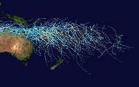
Northwestern Pacific Ocean
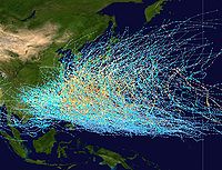
The Northwest Pacific Ocean is the most active basin on the planet. Annually, an average of 25.7 tropical cyclones in the basin acquire tropical storm strength or greater; also, an average of 16 typhoons occurred each year during the 1968–1989 period. The basin occupies all the territory north of the equator
Equator
An equator is the intersection of a sphere's surface with the plane perpendicular to the sphere's axis of rotation and containing the sphere's center of mass....
and west of the International Date Line
International Date Line
The International Date Line is a generally north-south imaginary line on the surface of the Earth, passing through the middle of the Pacific Ocean, that designates the place where each calendar day begins...
, including the South China Sea
South China Sea
The South China Sea is a marginal sea that is part of the Pacific Ocean, encompassing an area from the Singapore and Malacca Straits to the Strait of Taiwan of around...
. The basin sees activity year-round; however, tropical activity is at its minimum in February and March.
Tropical storms in this region often affect China
China
Chinese civilization may refer to:* China for more general discussion of the country.* Chinese culture* Greater China, the transnational community of ethnic Chinese.* History of China* Sinosphere, the area historically affected by Chinese culture...
, Japan
Japan
Japan is an island nation in East Asia. Located in the Pacific Ocean, it lies to the east of the Sea of Japan, China, North Korea, South Korea and Russia, stretching from the Sea of Okhotsk in the north to the East China Sea and Taiwan in the south...
, South Korea
South Korea
The Republic of Korea , , is a sovereign state in East Asia, located on the southern portion of the Korean Peninsula. It is neighbored by the People's Republic of China to the west, Japan to the east, North Korea to the north, and the East China Sea and Republic of China to the south...
, Hong Kong
Hong Kong
Hong Kong is one of two Special Administrative Regions of the People's Republic of China , the other being Macau. A city-state situated on China's south coast and enclosed by the Pearl River Delta and South China Sea, it is renowned for its expansive skyline and deep natural harbour...
, the Philippines
Philippines
The Philippines , officially known as the Republic of the Philippines , is a country in Southeast Asia in the western Pacific Ocean. To its north across the Luzon Strait lies Taiwan. West across the South China Sea sits Vietnam...
, and Taiwan
Taiwan
Taiwan , also known, especially in the past, as Formosa , is the largest island of the same-named island group of East Asia in the western Pacific Ocean and located off the southeastern coast of mainland China. The island forms over 99% of the current territory of the Republic of China following...
, as well as countries in Southeast Asia such as Vietnam
Vietnam
Vietnam – sometimes spelled Viet Nam , officially the Socialist Republic of Vietnam – is the easternmost country on the Indochina Peninsula in Southeast Asia. It is bordered by China to the north, Laos to the northwest, Cambodia to the southwest, and the South China Sea –...
and parts of Indonesia
Indonesia
Indonesia , officially the Republic of Indonesia , is a country in Southeast Asia and Oceania. Indonesia is an archipelago comprising approximately 13,000 islands. It has 33 provinces with over 238 million people, and is the world's fourth most populous country. Indonesia is a republic, with an...
, plus numerous Oceania
Oceania
Oceania is a region centered on the islands of the tropical Pacific Ocean. Conceptions of what constitutes Oceania range from the coral atolls and volcanic islands of the South Pacific to the entire insular region between Asia and the Americas, including Australasia and the Malay Archipelago...
n islands. This is by far the most active basin, accounting for one-third of all tropical cyclone activity. The coast of China
People's Republic of China
China , officially the People's Republic of China , is the most populous country in the world, with over 1.3 billion citizens. Located in East Asia, the country covers approximately 9.6 million square kilometres...
sees the most landfalling tropical cyclones worldwide. The Philippines archipelago
Archipelago
An archipelago , sometimes called an island group, is a chain or cluster of islands. The word archipelago is derived from the Greek ἄρχι- – arkhi- and πέλαγος – pélagos through the Italian arcipelago...
receives an average of 6-7 tropical cyclone landfalls per year.
North Indian Ocean
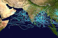
Bay of Bengal
The Bay of Bengal , the largest bay in the world, forms the northeastern part of the Indian Ocean. It resembles a triangle in shape, and is bordered mostly by the Eastern Coast of India, southern coast of Bangladesh and Sri Lanka to the west and Burma and the Andaman and Nicobar Islands to the...
and the Arabian Sea
Arabian Sea
The Arabian Sea is a region of the Indian Ocean bounded on the east by India, on the north by Pakistan and Iran, on the west by the Arabian Peninsula, on the south, approximately, by a line between Cape Guardafui in northeastern Somalia and Kanyakumari in India...
, with the Bay of Bengal dominating (5 to 6 times more activity). Still, this basin is the most inactive worldwide, with only 4 to 6 storms per year. This basin's season has a double peak: one in April and May, before the onset of the monsoon
Monsoon
Monsoon is traditionally defined as a seasonal reversing wind accompanied by corresponding changes in precipitation, but is now used to describe seasonal changes in atmospheric circulation and precipitation associated with the asymmetric heating of land and sea...
, and another in October and November, just after. Although it is an inactive basin, the deadliest tropical cyclones in the world have formed here, including the 1970 Bhola cyclone
1970 Bhola cyclone
The 1970 Bhola cyclone was a devastating tropical cyclone that struck East Pakistan and India's West Bengal on November 12, 1970. It was the deadliest tropical cyclone ever recorded, and one of the deadliest natural disasters in modern times...
, which killed 500,000 people. Nations affected include India
India
India , officially the Republic of India , is a country in South Asia. It is the seventh-largest country by geographical area, the second-most populous country with over 1.2 billion people, and the most populous democracy in the world...
, Bangladesh
Bangladesh
Bangladesh , officially the People's Republic of Bangladesh is a sovereign state located in South Asia. It is bordered by India on all sides except for a small border with Burma to the far southeast and by the Bay of Bengal to the south...
, Sri Lanka
Sri Lanka
Sri Lanka, officially the Democratic Socialist Republic of Sri Lanka is a country off the southern coast of the Indian subcontinent. Known until 1972 as Ceylon , Sri Lanka is an island surrounded by the Indian Ocean, the Gulf of Mannar and the Palk Strait, and lies in the vicinity of India and the...
, Thailand
Thailand
Thailand , officially the Kingdom of Thailand , formerly known as Siam , is a country located at the centre of the Indochina peninsula and Southeast Asia. It is bordered to the north by Burma and Laos, to the east by Laos and Cambodia, to the south by the Gulf of Thailand and Malaysia, and to the...
, Myanmar
Myanmar
Burma , officially the Republic of the Union of Myanmar , is a country in Southeast Asia. Burma is bordered by China on the northeast, Laos on the east, Thailand on the southeast, Bangladesh on the west, India on the northwest, the Bay of Bengal to the southwest, and the Andaman Sea on the south....
, and Pakistan
Pakistan
Pakistan , officially the Islamic Republic of Pakistan is a sovereign state in South Asia. It has a coastline along the Arabian Sea and the Gulf of Oman in the south and is bordered by Afghanistan and Iran in the west, India in the east and China in the far northeast. In the north, Tajikistan...
. Rarely do tropical cyclones that form in this basin affect the Arabian Peninsula
Arabian Peninsula
The Arabian Peninsula is a land mass situated north-east of Africa. Also known as Arabia or the Arabian subcontinent, it is the world's largest peninsula and covers 3,237,500 km2...
or Somalia
Somalia
Somalia , officially the Somali Republic and formerly known as the Somali Democratic Republic under Socialist rule, is a country located in the Horn of Africa. Since the outbreak of the Somali Civil War in 1991 there has been no central government control over most of the country's territory...
; however, Cyclone Gonu
Cyclone Gonu
Cyclone Gonu is the strongest tropical cyclone on record in the Arabian Sea, and is also the strongest named cyclone in the northern Indian Ocean...
caused heavy damage in Oman on the peninsula in 2007.
South-West Indian Ocean

Météo-France
Météo-France is the French national meteorological service.The organisation was established by decree in June 1993 and is a department of the Ministry of Transportation. It is headquartered in Paris but many domestic operations have been decentralised to Toulouse...
began assigning additional personnel for research purposes. Cyclones forming in this area can affect Madagascar
Madagascar
The Republic of Madagascar is an island country located in the Indian Ocean off the southeastern coast of Africa...
, Mozambique
Mozambique
Mozambique, officially the Republic of Mozambique , is a country in southeastern Africa bordered by the Indian Ocean to the east, Tanzania to the north, Malawi and Zambia to the northwest, Zimbabwe to the west and Swaziland and South Africa to the southwest...
, Mauritius
Mauritius
Mauritius , officially the Republic of Mauritius is an island nation off the southeast coast of the African continent in the southwest Indian Ocean, about east of Madagascar...
, Réunion
Réunion
Réunion is a French island with a population of about 800,000 located in the Indian Ocean, east of Madagascar, about south west of Mauritius, the nearest island.Administratively, Réunion is one of the overseas departments of France...
, Comoros
Comoros
The Comoros , officially the Union of the Comoros is an archipelago island nation in the Indian Ocean, located off the eastern coast of Africa, on the northern end of the Mozambique Channel, between northeastern Mozambique and northwestern Madagascar...
, Tanzania
Tanzania
The United Republic of Tanzania is a country in East Africa bordered by Kenya and Uganda to the north, Rwanda, Burundi, and the Democratic Republic of the Congo to the west, and Zambia, Malawi, and Mozambique to the south. The country's eastern borders lie on the Indian Ocean.Tanzania is a state...
, and Kenya
Kenya
Kenya , officially known as the Republic of Kenya, is a country in East Africa that lies on the equator, with the Indian Ocean to its south-east...
. An average of about ten tropical cyclones form in this basin per year, and this basin, annually, is the deadliest worldwide, with up to 80 deaths in every season.
Australian region
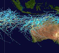
Australia
Australia , officially the Commonwealth of Australia, is a country in the Southern Hemisphere comprising the mainland of the Australian continent, the island of Tasmania, and numerous smaller islands in the Indian and Pacific Oceans. It is the world's sixth-largest country by total area...
and Indonesia
Indonesia
Indonesia , officially the Republic of Indonesia , is a country in Southeast Asia and Oceania. Indonesia is an archipelago comprising approximately 13,000 islands. It has 33 provinces with over 238 million people, and is the world's fourth most populous country. Indonesia is a republic, with an...
. According to the Australian Bureau of Meteorology, the most frequently hit portion of Australia is between Exmouth
Exmouth, Western Australia
-Further reading:* Western Australia. Ministry for Planning. Exmouth-Learmonth structure plan. Perth, W.A. : Western Australian Planning Commission...
and Broome
Broome, Western Australia
Broome is a pearling and tourist town in the Kimberley region of Western Australia, north of Perth. The year round population is approximately 14,436, growing to more than 45,000 per month during the tourist season...
in Western Australia
Western Australia
Western Australia is a state of Australia, occupying the entire western third of the Australian continent. It is bounded by the Indian Ocean to the north and west, the Great Australian Bight and Indian Ocean to the south, the Northern Territory to the north-east and South Australia to the south-east...
. The basin sees an average of about seven cyclones each year, although more can form or come in from other basins, like the South Pacific. Only about five cyclones reach Category 5 each year. The tropical cyclone Cyclone Vance
Cyclone Vance
Cyclone Vance was a tropical cyclone that struck Western Australia during the active 1998–99 Australian region cyclone season, and was also one of six tropical cyclones to form off the coast of Australia during that season. When making landfall the Learmonth Meteorological Office recorded the...
in 1999 produced the highest recorded speed winds in an Australian town or city at around 267 km/h.
South Pacific Ocean
South Atlantic Ocean
Cyclones form rarely or never in other tropical ocean areas, which are not formally considered tropical cyclone basins. Tropical depressions and tropical storms occur occasionally in the South Atlantic, and the only full-blown tropical cyclones on record were 2004's Cyclone CatarinaCyclone Catarina
Cyclone Catarina is one of several informal names for a South Atlantic tropical cyclone that hit southeastern Brazil in late March 2004. The storm developed out of a stationary cold-core upper-level trough on March 12...
, which made landfall in Brazil
Brazil
Brazil , officially the Federative Republic of Brazil , is the largest country in South America. It is the world's fifth largest country, both by geographical area and by population with over 192 million people...
, 2010's Tropical Storm Anita
Tropical Storm Anita (2010)
Tropical Storm Anita was the second tropical cyclone in the Southern Atlantic Ocean on record, following Cyclone Catarina in March 2004. Originating from an extratropical cyclone over southern Brazil, this system quickly moved offshore, entering a region favoring subtropical development...
, which formed off the coast of Rio Grande do Sul
Rio Grande do Sul
Rio Grande do Sul is the southernmost state in Brazil, and the state with the fifth highest Human Development Index in the country. In this state is located the southernmost city in the country, Chuí, on the border with Uruguay. In the region of Bento Gonçalves and Caxias do Sul, the largest wine...
, and 2011's Subtropical Storm Arani
Subtropical Storm Arani
Subtropical Cyclone Arani was a subtropical cyclone that existed in March 2011 in the South Atlantic. Arani was the ninth recorded storm in South Atlantic history, fourth subtropical cyclone, third named storm, and first officially named subtropical storm....
, which formed off Brazil.
Mediterranean Sea
On rare occasions, tropical-like systems occur over the Mediterranean SeaMediterranean Sea
The Mediterranean Sea is a sea connected to the Atlantic Ocean surrounded by the Mediterranean region and almost completely enclosed by land: on the north by Anatolia and Europe, on the south by North Africa, and on the east by the Levant...
. These systems are a subject of some debate within meteorological circles whether they closely fit the definition of tropical cyclone
Tropical cyclone
A tropical cyclone is a storm system characterized by a large low-pressure center and numerous thunderstorms that produce strong winds and heavy rain. Tropical cyclones strengthen when water evaporated from the ocean is released as the saturated air rises, resulting in condensation of water vapor...
s, subtropical cyclone
Subtropical cyclone
A subtropical cyclone is a weather system that has some characteristics of a tropical and an extratropical cyclone. As early as the 1950s, meteorologists were unclear whether they should be characterized as tropical or extratropical cyclones. They were officially recognized by the National...
s, or polar low
Polar low
A polar low is a small-scale, long-lived atmospheric low pressure system that is found over the ocean areas poleward of the main polar front in both the Northern and Southern Hemispheres. The systems usually have a horizontal length scale of less than and exist for no more than a couple of days. ...
s. Their origins are typically non-tropical, and develop over open waters under strong, initially cold-core cyclone
Cyclone
In meteorology, a cyclone is an area of closed, circular fluid motion rotating in the same direction as the Earth. This is usually characterized by inward spiraling winds that rotate anticlockwise in the Northern Hemisphere and clockwise in the Southern Hemisphere of the Earth. Most large-scale...
s, similar to subtropical cyclones in the Atlantic Basin. Sea surface temperatures in late-August and early-September are quite high over the basin (+24/+28°C), though research indicates water temperatures of 20 °C/68 °F are normally required for development.
Meteorological literature documents that such systems occurred in September 1947, September 1969, January 1982, September 1983, January 1995 and November 2011 (the latter officially classified as Tropical Storm 01M). The 1995 system developed a well-defined eye
Eye (cyclone)
The eye is a region of mostly calm weather found at the center of strong tropical cyclones. The eye of a storm is a roughly circular area and typically 30–65 km in diameter. It is surrounded by the eyewall, a ring of towering thunderstorms where the second most severe weather of a cyclone...
, and a ship recorded 85 mph (140 km/h) winds, along with an atmospheric pressure
Atmospheric pressure
Atmospheric pressure is the force per unit area exerted into a surface by the weight of air above that surface in the atmosphere of Earth . In most circumstances atmospheric pressure is closely approximated by the hydrostatic pressure caused by the weight of air above the measurement point...
of 975 mbar
Bar (unit)
The bar is a unit of pressure equal to 100 kilopascals, and roughly equal to the atmospheric pressure on Earth at sea level. Other units derived from the bar are the megabar , kilobar , decibar , centibar , and millibar...
. Although it had the structure of a tropical cyclone, it occurred over 61 °F (16.1 °C) water temperatures, suggesting it could have been a polar low
Polar low
A polar low is a small-scale, long-lived atmospheric low pressure system that is found over the ocean areas poleward of the main polar front in both the Northern and Southern Hemispheres. The systems usually have a horizontal length scale of less than and exist for no more than a couple of days. ...
.