
.gif)
Tropical Storm Dean (2001)
Encyclopedia
Tropical Storm Dean was a strong tropical storm that affected at least twelve islands along its path from the tropical Atlantic Ocean
to east of Atlantic Canada
. Dean developed from a tropical wave
on August 22 over the Lesser Antilles
, and was initially predicted to intensify further to reach hurricane status. However, strong wind shear
quickly weakened Dean to cause it to dissipate on August 23. The remnants turned northward, and redeveloped on August 26 to the north of Bermuda
. Located over warm waters and in an area of favorable conditions, Dean steadily strengthened while moving to the northeast, and peaked just below hurricane status on August 27 about 465 miles (750 km) southwest of Newfoundland. The storm subsequently weakened over cooler waters, and became extratropical on August 28.
The precursor tropical wave dropped heavy rainfall and produced moderate winds throughout the Lesser Antilles
, though no serious damage was reported. In Puerto Rico
, rainfall of up to 12.7 inches (322 mm) produced widespread flooding across the island. Thousands were left without power or water, and two houses lost their roofs from the storm. The passage of Dean resulted in $7.7 million (2001 USD, $9.4 million 2008 USD) in damage in Puerto Rico. The storm produced light to moderate rainfall in Bermuda
and later in Newfoundland, though no damage was reported.
near Dakar
between August 14 and August 15. It moved westward, and gradually developed thunderstorms across the wave axis. On August 21, while located about 450 miles (725 km) east of the Lesser Antilles
, convection increased further within the system, though unfavorable upper-level wind shear
prevented rapid development. It continued to become better organized, and though a Reconnaissance flight
into the system reported strong winds, it lacked a surface circulation. Late on August 21 the wave passed through the northern Lesser Antilles, and subsequent to a decrease in wind shear the system became much better organized on August 22. A surface circulation formed, and the system developed into Tropical Storm Dean on August 22 near Saint Croix
. Dean was upgraded directly to a tropical storm due to the presence of 50 mph (80 km/h) winds in the storm.
Reconnaissance Aircraft and surface reports confirmed the existence of a circulation. Dean moved northwestward at 22 mph (35 km/h), under the influence of the Bermuda High
to its northeast. The storm strengthened slightly to reach winds of 60 mph (95 km/h) later on August 22, though the circulation was exposed on the western edge of the convection due to the storm's quick forward motion and persistent wind shear
. Initial forecasts predicted the shear to decrease, allowing Dean to attain hurricane status with winds of over 80 mph (130 km/h). However, an upper-level trough
produced an increase of shear over the storm, and by August 23 Dean weakened to a tropical depression. Hours later, the circulation dissipated, and Dean degenerated into a tropical wave to the east of the Bahamas. Regeneration was considered unlikely at the time.
The remnants of Dean turned to the north, and became embedded within a large mid-level trough off the East Coast of the United States
. Convection increased around the system early on August 24. The system became better organized, with indications of a broad surface circulation forming about 400 miles (645 km) west-southwest of Bermuda
. However, a reconnaissance flight into the remnants of Dean reported a broad low pressure area
with the strongest winds and convection located far from the area of minimum pressure, indicating it had some non-tropical characteristics
. The weak disturbance passed to the west of Bermuda early on August 25, and subsequently began to drift to the northeast. The remnants of Dean produced convection near its developing circulation, and on August 26, while located 220 miles (350 km) north of Bermuda the system organized sufficiently enough to be re-classified a tropical depression. Operationally, the National Hurricane Center
did not re-initiate advisories until fifteen hours later.
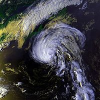 The depression continued to the northeast, and re-strengthened into Tropical Storm Dean early on August 27 while located 580 miles (930 km) south of Halifax, Nova Scotia. The convection became better organized, and Dean steadily strengthened as it tracked northeastward. A ship near the center of Dean confirmed the storm re-developed. The convection near the center greatly organized, and an eye feature
began to develop. Remaining over warm waters, Dean continued to strengthen and reached peak winds of 70 mph (110 km/h) late on August 27 while located about 465 miles (750 km) southwest of Cape Race
, Newfoundland
. The eye feature failed to develop further, and after maintaining its peak intensity for 12 hours Dean weakened over progressively cooler waters. The convection quickly diminished, and on August 28 Dean became extratropical while located 145 miles (235 km) east-southeast of Cape Race, Newfoundland. The extratropical storm continued northeastward until being absorbed by a frontal low
on August 29.
to monitor the progress of the storm. Routine statements issued by the National Hurricane Center warned for the possibility of strong winds and heavy rains. However, because Dean formed after it passed the islands, no tropical cyclone warnings or watches
were issued. The precursor disturbance dropped heavy rainfall on Saint Martin
of around 5 inches (129 mm).
.jpg) The precursor disturbance to Tropical Storm Dean produced 1.07 inches (27 mm) of rain in Saint Thomas
The precursor disturbance to Tropical Storm Dean produced 1.07 inches (27 mm) of rain in Saint Thomas
, where winds reached 40 mph (64 km/h) with gusts to 48 mph (77 km/h). On Saint Croix
, the system produced 0.49 inches (12 mm) of rain and peak wind gusts of 47 mph (76 km/h). There, minor flooding was reported. Moderate wind gusts downed small trees and branches in Saint Croix and Saint John
, and some roads were damaged in Saint John, as well. Heavy rains and gusty winds caused power outages throughout the U.S. Virgin Islands. The passage of Tropical Storm Dean resulted in minor damage totaling to $20,000 (2001 USD, $24,400 2008 USD).
Tropical Storm Dean dropped heavy rainfall across Puerto Rico
, peaking at 12.7 inches (322 mm) in Salinas
. Winds were generally light across the island. The passage of Dean resulted in widespread flooding in eastern and southern Puerto Rico, collapsing two bridges and one road. Several highways were under water, and one car was swept away by the floodwaters. The four inside the vehicle were later rescued and unharmed. Throughout the island, about 1,320 houses were flooded, and two houses experienced collapsed roofs. The rains left various towns without power or water. By the night after the storm passed the island, more than 16,000 were without power, while almost 70,000 lacked potable water. Over 130 people were evacuated from low-lying areas to hurricane shelters.
Two people were injured in Peñuelas
, and three were injured in Nagüabo
when the ceiling of a day care center collapsed, though no deaths occurred on the island. One airline canceled seventeen flights in and out of the island, and one cruise line was required to alter its path to both Dean and earlier due to Tropical Storm Chantal
. Damage in Puerto Rico totaled to $7.7 million (2001 USD, $9.4 million 2008 USD), of which $2.1 million (2001 USD, $2.6 million 2008 USD) was from agricultural damage.
for the southeastern Bahamas and the Turks and Caicos Islands
. When the storm weakened and ultimately dissipated, the warnings were canceled. The remnants of Dean produced unsettled conditions across Bermuda
, including a wind gust of 41 mph (66 km/h) and light rainfall of 0.31 inches (8 mm). The passage of Dean resulted in the coldest day of August 2001 on the island. Dean produced wind gusts peaking at 63 mph (103 km/h) in Newfoundland, along with rainfall up to 4.2 inches (107 mm) in eastern Newfoundland. On land, wave heights reached 30 feet (9.3 m), while a buoy
offshore reported a peak wave height of 47 feet (14.4 m).
Atlantic Ocean
The Atlantic Ocean is the second-largest of the world's oceanic divisions. With a total area of about , it covers approximately 20% of the Earth's surface and about 26% of its water surface area...
to east of Atlantic Canada
Atlantic Canada
Atlantic Canada is the region of Canada comprising the four provinces located on the Atlantic coast, excluding Quebec: the three Maritime provinces – New Brunswick, Prince Edward Island, and Nova Scotia – and Newfoundland and Labrador...
. Dean developed from a tropical wave
Tropical wave
Tropical waves, easterly waves, or tropical easterly waves, also known as African easterly waves in the Atlantic region, are a type of atmospheric trough, an elongated area of relatively low air pressure, oriented north to south, which move from east to west across the tropics causing areas of...
on August 22 over the Lesser Antilles
Lesser Antilles
The Lesser Antilles are a long, partly volcanic island arc in the Western Hemisphere. Most of its islands form the eastern boundary of the Caribbean Sea with the Atlantic Ocean, with the remainder located in the southern Caribbean just north of South America...
, and was initially predicted to intensify further to reach hurricane status. However, strong wind shear
Wind shear
Wind shear, sometimes referred to as windshear or wind gradient, is a difference in wind speed and direction over a relatively short distance in the atmosphere...
quickly weakened Dean to cause it to dissipate on August 23. The remnants turned northward, and redeveloped on August 26 to the north of Bermuda
Bermuda
Bermuda is a British overseas territory in the North Atlantic Ocean. Located off the east coast of the United States, its nearest landmass is Cape Hatteras, North Carolina, about to the west-northwest. It is about south of Halifax, Nova Scotia, Canada, and northeast of Miami, Florida...
. Located over warm waters and in an area of favorable conditions, Dean steadily strengthened while moving to the northeast, and peaked just below hurricane status on August 27 about 465 miles (750 km) southwest of Newfoundland. The storm subsequently weakened over cooler waters, and became extratropical on August 28.
The precursor tropical wave dropped heavy rainfall and produced moderate winds throughout the Lesser Antilles
Lesser Antilles
The Lesser Antilles are a long, partly volcanic island arc in the Western Hemisphere. Most of its islands form the eastern boundary of the Caribbean Sea with the Atlantic Ocean, with the remainder located in the southern Caribbean just north of South America...
, though no serious damage was reported. In Puerto Rico
Puerto Rico
Puerto Rico , officially the Commonwealth of Puerto Rico , is an unincorporated territory of the United States, located in the northeastern Caribbean, east of the Dominican Republic and west of both the United States Virgin Islands and the British Virgin Islands.Puerto Rico comprises an...
, rainfall of up to 12.7 inches (322 mm) produced widespread flooding across the island. Thousands were left without power or water, and two houses lost their roofs from the storm. The passage of Dean resulted in $7.7 million (2001 USD, $9.4 million 2008 USD) in damage in Puerto Rico. The storm produced light to moderate rainfall in Bermuda
Bermuda
Bermuda is a British overseas territory in the North Atlantic Ocean. Located off the east coast of the United States, its nearest landmass is Cape Hatteras, North Carolina, about to the west-northwest. It is about south of Halifax, Nova Scotia, Canada, and northeast of Miami, Florida...
and later in Newfoundland, though no damage was reported.
Meteorological history
A large tropical wave with minimal convection moved off the coast of AfricaAfrica
Africa is the world's second largest and second most populous continent, after Asia. At about 30.2 million km² including adjacent islands, it covers 6% of the Earth's total surface area and 20.4% of the total land area...
near Dakar
Dakar
Dakar is the capital city and largest city of Senegal. It is located on the Cap-Vert Peninsula on the Atlantic coast and is the westernmost city on the African mainland...
between August 14 and August 15. It moved westward, and gradually developed thunderstorms across the wave axis. On August 21, while located about 450 miles (725 km) east of the Lesser Antilles
Lesser Antilles
The Lesser Antilles are a long, partly volcanic island arc in the Western Hemisphere. Most of its islands form the eastern boundary of the Caribbean Sea with the Atlantic Ocean, with the remainder located in the southern Caribbean just north of South America...
, convection increased further within the system, though unfavorable upper-level wind shear
Wind shear
Wind shear, sometimes referred to as windshear or wind gradient, is a difference in wind speed and direction over a relatively short distance in the atmosphere...
prevented rapid development. It continued to become better organized, and though a Reconnaissance flight
Hurricane Hunters
The Hurricane Hunters are aircraft that fly into tropical cyclones in the North Atlantic Ocean and Northeastern Pacific Ocean for the specific purpose of directly measuring weather data in and around those storms. In the United States, the Air Force, Navy, and NOAA units have all participated in...
into the system reported strong winds, it lacked a surface circulation. Late on August 21 the wave passed through the northern Lesser Antilles, and subsequent to a decrease in wind shear the system became much better organized on August 22. A surface circulation formed, and the system developed into Tropical Storm Dean on August 22 near Saint Croix
Saint Croix, U.S. Virgin Islands
Saint Croix is an island in the Caribbean Sea, and a county and constituent district of the United States Virgin Islands , an unincorporated territory of the United States. Formerly the Danish West Indies, they were sold to the United States by Denmark in the Treaty of the Danish West Indies of...
. Dean was upgraded directly to a tropical storm due to the presence of 50 mph (80 km/h) winds in the storm.
Reconnaissance Aircraft and surface reports confirmed the existence of a circulation. Dean moved northwestward at 22 mph (35 km/h), under the influence of the Bermuda High
Anticyclone
An anticyclone is a weather phenomenon defined by the United States' National Weather Service's glossary as "[a] large-scale circulation of winds around a central region of high atmospheric pressure, clockwise in the Northern Hemisphere, counterclockwise in the Southern Hemisphere"...
to its northeast. The storm strengthened slightly to reach winds of 60 mph (95 km/h) later on August 22, though the circulation was exposed on the western edge of the convection due to the storm's quick forward motion and persistent wind shear
Wind shear
Wind shear, sometimes referred to as windshear or wind gradient, is a difference in wind speed and direction over a relatively short distance in the atmosphere...
. Initial forecasts predicted the shear to decrease, allowing Dean to attain hurricane status with winds of over 80 mph (130 km/h). However, an upper-level trough
Trough (meteorology)
A trough is an elongated region of relatively low atmospheric pressure, often associated with fronts.Unlike fronts, there is not a universal symbol for a trough on a weather chart. The weather charts in some countries or regions mark troughs by a line. In the United States, a trough may be marked...
produced an increase of shear over the storm, and by August 23 Dean weakened to a tropical depression. Hours later, the circulation dissipated, and Dean degenerated into a tropical wave to the east of the Bahamas. Regeneration was considered unlikely at the time.
The remnants of Dean turned to the north, and became embedded within a large mid-level trough off the East Coast of the United States
East Coast of the United States
The East Coast of the United States, also known as the Eastern Seaboard, refers to the easternmost coastal states in the United States, which touch the Atlantic Ocean and stretch up to Canada. The term includes the U.S...
. Convection increased around the system early on August 24. The system became better organized, with indications of a broad surface circulation forming about 400 miles (645 km) west-southwest of Bermuda
Bermuda
Bermuda is a British overseas territory in the North Atlantic Ocean. Located off the east coast of the United States, its nearest landmass is Cape Hatteras, North Carolina, about to the west-northwest. It is about south of Halifax, Nova Scotia, Canada, and northeast of Miami, Florida...
. However, a reconnaissance flight into the remnants of Dean reported a broad low pressure area
Low pressure area
A low-pressure area, or "low", is a region where the atmospheric pressure at sea level is below that of surrounding locations. Low-pressure systems form under areas of wind divergence which occur in upper levels of the troposphere. The formation process of a low-pressure area is known as...
with the strongest winds and convection located far from the area of minimum pressure, indicating it had some non-tropical characteristics
Tropical cyclone
A tropical cyclone is a storm system characterized by a large low-pressure center and numerous thunderstorms that produce strong winds and heavy rain. Tropical cyclones strengthen when water evaporated from the ocean is released as the saturated air rises, resulting in condensation of water vapor...
. The weak disturbance passed to the west of Bermuda early on August 25, and subsequently began to drift to the northeast. The remnants of Dean produced convection near its developing circulation, and on August 26, while located 220 miles (350 km) north of Bermuda the system organized sufficiently enough to be re-classified a tropical depression. Operationally, the National Hurricane Center
National Hurricane Center
The National Hurricane Center , located at Florida International University in Miami, Florida, is the division of the National Weather Service responsible for tracking and predicting weather systems within the tropics between the Prime Meridian and the 140th meridian west poleward to the 30th...
did not re-initiate advisories until fifteen hours later.
Eye (cyclone)
The eye is a region of mostly calm weather found at the center of strong tropical cyclones. The eye of a storm is a roughly circular area and typically 30–65 km in diameter. It is surrounded by the eyewall, a ring of towering thunderstorms where the second most severe weather of a cyclone...
began to develop. Remaining over warm waters, Dean continued to strengthen and reached peak winds of 70 mph (110 km/h) late on August 27 while located about 465 miles (750 km) southwest of Cape Race
Cape Race
Cape Race is a point of land located at the southeastern tip of the Avalon Peninsula on the island of Newfoundland, Canada. Its name is thought to come from the original Portuguese name for this cape, "Raso", or "bare"...
, Newfoundland
Newfoundland and Labrador
Newfoundland and Labrador is the easternmost province of Canada. Situated in the country's Atlantic region, it incorporates the island of Newfoundland and mainland Labrador with a combined area of . As of April 2011, the province's estimated population is 508,400...
. The eye feature failed to develop further, and after maintaining its peak intensity for 12 hours Dean weakened over progressively cooler waters. The convection quickly diminished, and on August 28 Dean became extratropical while located 145 miles (235 km) east-southeast of Cape Race, Newfoundland. The extratropical storm continued northeastward until being absorbed by a frontal low
Surface weather analysis
Surface weather analysis is a special type of weather map that provides a view of weather elements over a geographical area at a specified time based on information from ground-based weather stations...
on August 29.
Caribbean
About a day before Dean developed, the National Hurricane Center advised interests in the northern and central Lesser AntillesLesser Antilles
The Lesser Antilles are a long, partly volcanic island arc in the Western Hemisphere. Most of its islands form the eastern boundary of the Caribbean Sea with the Atlantic Ocean, with the remainder located in the southern Caribbean just north of South America...
to monitor the progress of the storm. Routine statements issued by the National Hurricane Center warned for the possibility of strong winds and heavy rains. However, because Dean formed after it passed the islands, no tropical cyclone warnings or watches
Tropical cyclone warnings and watches
Warnings and watches are two levels of alert issued by national weather forecasting bodies to coastal areas threatened by the imminent approach of a tropical cyclone of tropical storm or hurricane intensity. They are notices to the local population and civil authorities to make appropriate...
were issued. The precursor disturbance dropped heavy rainfall on Saint Martin
Saint Martin
Saint Martin is an island in the northeast Caribbean, approximately east of Puerto Rico. The 87 km2 island is divided roughly 60/40 between France and the Kingdom of the Netherlands ; however, the Dutch side has the larger population. It is one of the smallest sea islands divided between...
of around 5 inches (129 mm).
Saint Thomas, U.S. Virgin Islands
Saint Thomas is an island in the Caribbean Sea and with the islands of Saint John, Saint Croix, and Water Island a county and constituent district of the United States Virgin Islands , an unincorporated territory of the United States. Located on the island is the territorial capital and port of...
, where winds reached 40 mph (64 km/h) with gusts to 48 mph (77 km/h). On Saint Croix
Saint Croix, U.S. Virgin Islands
Saint Croix is an island in the Caribbean Sea, and a county and constituent district of the United States Virgin Islands , an unincorporated territory of the United States. Formerly the Danish West Indies, they were sold to the United States by Denmark in the Treaty of the Danish West Indies of...
, the system produced 0.49 inches (12 mm) of rain and peak wind gusts of 47 mph (76 km/h). There, minor flooding was reported. Moderate wind gusts downed small trees and branches in Saint Croix and Saint John
Saint John, U.S. Virgin Islands
Saint John is an island in the Caribbean Sea and a constituent district of the United States Virgin Islands , an unincorporated territory of the United States. St...
, and some roads were damaged in Saint John, as well. Heavy rains and gusty winds caused power outages throughout the U.S. Virgin Islands. The passage of Tropical Storm Dean resulted in minor damage totaling to $20,000 (2001 USD, $24,400 2008 USD).
Tropical Storm Dean dropped heavy rainfall across Puerto Rico
Puerto Rico
Puerto Rico , officially the Commonwealth of Puerto Rico , is an unincorporated territory of the United States, located in the northeastern Caribbean, east of the Dominican Republic and west of both the United States Virgin Islands and the British Virgin Islands.Puerto Rico comprises an...
, peaking at 12.7 inches (322 mm) in Salinas
Salinas, Puerto Rico
Salinas is a small municipality in the southern part of Puerto Rico located in the southern coast of the island, south of Aibonito and Cayey; southeast of Coamo, east of Santa Isabel; and west of Guayama...
. Winds were generally light across the island. The passage of Dean resulted in widespread flooding in eastern and southern Puerto Rico, collapsing two bridges and one road. Several highways were under water, and one car was swept away by the floodwaters. The four inside the vehicle were later rescued and unharmed. Throughout the island, about 1,320 houses were flooded, and two houses experienced collapsed roofs. The rains left various towns without power or water. By the night after the storm passed the island, more than 16,000 were without power, while almost 70,000 lacked potable water. Over 130 people were evacuated from low-lying areas to hurricane shelters.
Two people were injured in Peñuelas
Peñuelas, Puerto Rico
Peñuelas is a municipality in Puerto Rico located in the southern coast of the island, south of Adjuntas, east of Guayanilla, west of Ponce and north of the Caribbean Sea. Peñuelas is spread over 12 wards and Peñuelas Pueblo . It is part of the Yauco Metropolitan Statistical Area...
, and three were injured in Nagüabo
Nagüabo, Puerto Rico
Naguabo is a municipality in Puerto Rico located in the east coast of the island, north of Humacao; south of Río Grande and Ceiba; and east of Las Piedras. Naguabo is spread over 8 wards and Naguabo Pueblo...
when the ceiling of a day care center collapsed, though no deaths occurred on the island. One airline canceled seventeen flights in and out of the island, and one cruise line was required to alter its path to both Dean and earlier due to Tropical Storm Chantal
Tropical Storm Chantal (2001)
Tropical Storm Chantal was an Atlantic tropical cyclone that moved across the Caribbean Sea in August 2001. Chantal developed from a tropical wave on August 14 in the tropical Atlantic Ocean. It tracked rapidly westward for much of its duration, and after degenerating into a tropical wave...
. Damage in Puerto Rico totaled to $7.7 million (2001 USD, $9.4 million 2008 USD), of which $2.1 million (2001 USD, $2.6 million 2008 USD) was from agricultural damage.
Bahamas, Bermuda, and Canada
Shortly after Dean formed, the government of the Bahamas issued a tropical storm warningTropical cyclone warnings and watches
Warnings and watches are two levels of alert issued by national weather forecasting bodies to coastal areas threatened by the imminent approach of a tropical cyclone of tropical storm or hurricane intensity. They are notices to the local population and civil authorities to make appropriate...
for the southeastern Bahamas and the Turks and Caicos Islands
Turks and Caicos Islands
The Turks and Caicos Islands are a British Overseas Territory and overseas territory of the European Union consisting of two groups of tropical islands in the Caribbean, the larger Caicos Islands and the smaller Turks Islands, known for tourism and as an offshore financial centre.The Turks and...
. When the storm weakened and ultimately dissipated, the warnings were canceled. The remnants of Dean produced unsettled conditions across Bermuda
Bermuda
Bermuda is a British overseas territory in the North Atlantic Ocean. Located off the east coast of the United States, its nearest landmass is Cape Hatteras, North Carolina, about to the west-northwest. It is about south of Halifax, Nova Scotia, Canada, and northeast of Miami, Florida...
, including a wind gust of 41 mph (66 km/h) and light rainfall of 0.31 inches (8 mm). The passage of Dean resulted in the coldest day of August 2001 on the island. Dean produced wind gusts peaking at 63 mph (103 km/h) in Newfoundland, along with rainfall up to 4.2 inches (107 mm) in eastern Newfoundland. On land, wave heights reached 30 feet (9.3 m), while a buoy
Buoy
A buoy is a floating device that can have many different purposes. It can be anchored or allowed to drift. The word, of Old French or Middle Dutch origin, is now most commonly in UK English, although some orthoepists have traditionally prescribed the pronunciation...
offshore reported a peak wave height of 47 feet (14.4 m).
See also
- Other storms of the same name
- Timeline of the 2001 Atlantic hurricane seasonTimeline of the 2001 Atlantic hurricane seasonThe timeline of the 2001 Atlantic hurricane season documents all the storm formations, strengthening, weakening, landfalls, extratropical transitions, as well as dissipation...