
Trisul
Encyclopedia
Trisul is a group of three Himalayan
mountain peaks of western Kumaun, with the highest (Trisul I) reaching 7120m. The three peaks resemble a trident - in Hindi
/Sanskrit
, Trishul, trident, is the weapon of Shiva
. The Trishul group forms the southeast corner of the ring of peaks enclosing the Nanda Devi
Sanctuary, about 15 kilometres (9 mi) west-southwest of Nanda Devi itself. The main peak, Trisul I, was the first peak over 7000 m (22,965.9 ft) to have ever been climbed, in 1907.
is a north-south ridge, with Trisul I at the north end and Trisul III at the south. The massif runs roughly North-South, and hence appears compressed when viewed from the south (Ranikhet
, Kausani
), and more stretched out from the Southeast (Chamoli, Bedini Bugyal
).
Nanda Ghunti
lies a few kilometers to the northwest, while Mrigthuni is just to the southeast.
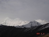
.jpg) T. G. Longstaff made the first climbing reconnaissance of Trisul, in September 1905, focussing on the western and southern sides. He returned in 1907 with two other Britons
T. G. Longstaff made the first climbing reconnaissance of Trisul, in September 1905, focussing on the western and southern sides. He returned in 1907 with two other Britons
, three Alpine
guides
, and a number of Gurkha
s. They ascended through the Rishiganga valley, to the north of the peak, onto the Trisul Glacier, which lies on the east side. From there they climbed the northeast flank to the north ridge, reaching the summit on June 12. At the time Trisul was probably the highest mountain to have been climbed
.
The climb was noted also for the first use of supplementary oxygen in a major climb
Routes on the west face and south ridge of Trisul I have also been climbed. The west face was first ascended in 1976; this was the first ascent of the main summit not using the first-ascent route.
Another Yugoslav expedition made the first traverse of the three peaks in 1987, and two members paraglided
from the summit.
- Kausani
- Garur
- Gwaldam
- Debal - Bagargad - Wan - Bedini Bugyal
- Kelva Vinayak - Roopkund
- Trisul.
Himalayas
The Himalaya Range or Himalaya Mountains Sanskrit: Devanagari: हिमालय, literally "abode of snow"), usually called the Himalayas or Himalaya for short, is a mountain range in Asia, separating the Indian subcontinent from the Tibetan Plateau...
mountain peaks of western Kumaun, with the highest (Trisul I) reaching 7120m. The three peaks resemble a trident - in Hindi
Hindi
Standard Hindi, or more precisely Modern Standard Hindi, also known as Manak Hindi , High Hindi, Nagari Hindi, and Literary Hindi, is a standardized and sanskritized register of the Hindustani language derived from the Khariboli dialect of Delhi...
/Sanskrit
Sanskrit
Sanskrit , is a historical Indo-Aryan language and the primary liturgical language of Hinduism, Jainism and Buddhism.Buddhism: besides Pali, see Buddhist Hybrid Sanskrit Today, it is listed as one of the 22 scheduled languages of India and is an official language of the state of Uttarakhand...
, Trishul, trident, is the weapon of Shiva
Shiva
Shiva is a major Hindu deity, and is the destroyer god or transformer among the Trimurti, the Hindu Trinity of the primary aspects of the divine. God Shiva is a yogi who has notice of everything that happens in the world and is the main aspect of life. Yet one with great power lives a life of a...
. The Trishul group forms the southeast corner of the ring of peaks enclosing the Nanda Devi
Nanda Devi
Nanda Devi is the second highest mountain in India and the highest entirely within the country ; owing to this geography it was the highest known mountain in the world until computations on Dhaulagiri by western surveyors in 1808...
Sanctuary, about 15 kilometres (9 mi) west-southwest of Nanda Devi itself. The main peak, Trisul I, was the first peak over 7000 m (22,965.9 ft) to have ever been climbed, in 1907.
Description of the massif and neighboring peaks
The three peaks are named Trisul I, Trisul II, and Trisul III. The massifMassif
In geology, a massif is a section of a planet's crust that is demarcated by faults or flexures. In the movement of the crust, a massif tends to retain its internal structure while being displaced as a whole...
is a north-south ridge, with Trisul I at the north end and Trisul III at the south. The massif runs roughly North-South, and hence appears compressed when viewed from the south (Ranikhet
Ranikhet
Ranikhet is a hill station and cantonment town in Almora district in the Indian state of Uttarakhand. It is the home for the Military Hospital, Kumaon Regiment & Naga Regiment and is maintained by the Indian Army....
, Kausani
Kausani
Kausani is a hill station situated in the bageshwar district of the Uttarakhand state of India.-Overview:Kausani is a destination for Himalayan tourists. It is located 53 km North of Almora. The altitude of this place is about 1890 mts. This place offers a 350 km view of the Himalayan peaks like...
), and more stretched out from the Southeast (Chamoli, Bedini Bugyal
Bedini Bugyal
Bedini Bugyal is the Himalayan Alpine meadow, situated at an altitude of 3354 meters in the Chamoli district of Uttarakhand state of India. Bedini Bugyal falls on the way to Roopkund near Wan village. Trisul and Nanda Ghunti are clearly visible from here. This lush green meadow is adorned with...
).
Nanda Ghunti
Nanda Ghunti
Nanda Ghunti is a 6,309 metre high mountain in Garhwal, IndiaIt lies on the Outer Rim of the Nanda Devi Sanctuary. It was first surveyed by TG Longstaff in 1907. Eric Shipton surveyed it from West in 1931. First serious attempt was made by BP Goodfellow J Buz , in 1944...
lies a few kilometers to the northwest, while Mrigthuni is just to the southeast.
| Mountain | Height (m) | Height (ft) | Coordinates | Prominence Topographic prominence In topography, prominence, also known as autonomous height, relative height, shoulder drop , or prime factor , categorizes the height of the mountain's or hill's summit by the elevation between it and the lowest contour line encircling it and no higher summit... (m) |
First ascent |
|---|---|---|---|---|---|
| Trisul I | 7,120 | 23,359 | 30°18′46"N 79°46′38"E | 1616 | 1907 |
| Trisul II | 6,690 | 21,949 | 30°17′24"N 79°46′12"E | <200 | 1960 |
| Trisul III | 6,007 | 19,708 | 30°15′00"N 79°46′12"E | <200 | 1960 |
Trisul I
United Kingdom
The United Kingdom of Great Britain and Northern IrelandIn the United Kingdom and Dependencies, other languages have been officially recognised as legitimate autochthonous languages under the European Charter for Regional or Minority Languages...
, three Alpine
Alps
The Alps is one of the great mountain range systems of Europe, stretching from Austria and Slovenia in the east through Italy, Switzerland, Liechtenstein and Germany to France in the west....
guides
Mountain guide
Mountain guides are specially trained and experienced mountaineers and professionals who are generally certified by an association. They are considered experts in mountaineering.-Skills:Their skills usually include climbing, skiing and hiking...
, and a number of Gurkha
Gurkha
Gurkha are people from Nepal who take their name from the Gorkha District. Gurkhas are best known for their history in the Indian Army's Gorkha regiments, the British Army's Brigade of Gurkhas and the Nepalese Army. Gurkha units are closely associated with the kukri, a forward-curving Nepalese knife...
s. They ascended through the Rishiganga valley, to the north of the peak, onto the Trisul Glacier, which lies on the east side. From there they climbed the northeast flank to the north ridge, reaching the summit on June 12. At the time Trisul was probably the highest mountain to have been climbed
World altitude record (mountaineering)
In the history of mountaineering, the world altitude record referred to the highest point on the Earth's surface which had been reached, regardless of whether that point was an actual summit. The world summit record referred to the highest mountain to have been successfully climbed...
.
The climb was noted also for the first use of supplementary oxygen in a major climb
Routes on the west face and south ridge of Trisul I have also been climbed. The west face was first ascended in 1976; this was the first ascent of the main summit not using the first-ascent route.
Trisul II and III
Trisul II and Trisul III were first climbed in 1960 by a Yugoslav team. They climbed from the Bidalgwar glacier, achieving the summit of Trisul II via the southern ridge and Trisul III via the north ridge.Another Yugoslav expedition made the first traverse of the three peaks in 1987, and two members paraglided
Paragliding
Paragliding is the recreational and competitive adventure sport of flying paragliders: lightweight, free-flying, foot-launched glider aircraft with no rigid primary structure...
from the summit.
Trivia
Alex Kunaver was a member of the first Yugoslav team which climbed Trisul in 1960. In 1987, his daughter Vlasta Kunaver climbed Trisul I and was one of the paragliders.Access
The Trisul massif can be accessed via the following route: AlmoraAlmora
Almora is a municipal board, a cantonment town in the Almora district in the state of Uttarakhand, India. Almora was founded in 1568.It is a town bustling with activity and a rich cultural heritage and history. It is considered the cultural heart of the Kumaon region of...
- Kausani
Kausani
Kausani is a hill station situated in the bageshwar district of the Uttarakhand state of India.-Overview:Kausani is a destination for Himalayan tourists. It is located 53 km North of Almora. The altitude of this place is about 1890 mts. This place offers a 350 km view of the Himalayan peaks like...
- Garur
Garur
Garur is a town in the Bageshwar district of the state of Uttarakhand, India.-Geography and demographics:Nearby places include Kausani, Baijnath, Gwaldam and Bageshwar....
- Gwaldam
Gwaldam
Gwaldam is a hill station, situated between the Garhwal and Kumaon. 30 km from Kausani.-Geography:Gwaldam is located at . It has an average elevation of 1,708 metres ....
- Debal - Bagargad - Wan - Bedini Bugyal
Bedini Bugyal
Bedini Bugyal is the Himalayan Alpine meadow, situated at an altitude of 3354 meters in the Chamoli district of Uttarakhand state of India. Bedini Bugyal falls on the way to Roopkund near Wan village. Trisul and Nanda Ghunti are clearly visible from here. This lush green meadow is adorned with...
- Kelva Vinayak - Roopkund
Roopkund
Roopkund is a glacial lake in Uttarakhand state of India famous due to more than five hundred human skeletons found at the edge of a lake...
- Trisul.
Other sources
- This My Voyage by T. G. LongstaffThomas George LongstaffTom George Longstaff was an English doctor, explorer and mountaineer, most famous for being the first person to climb a summit of over 7,000 meters in elevation, Trisul, in the Indian Himalaya in 1907. He also made important explorations and climbs in Tibet, Nepal, the Karakoram, Spitsbergen,...
. - Across Peaks and Passes of Kumaun Himalayas by Harish KapadiaHarish KapadiaHarish Kapadia is a distinguished Himalayan Mountaineer from India. He has been awarded the Patron's Medal of the Royal Geographic Society, UK and the Life Time Achievement Award for Adventure by the President of India and the King Albert Mountain Award presented by The King Albert I Memorial...
.