

Treptow-Köpenick
Encyclopedia
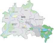
| Arms | Map | |
|---|---|---|
 |
 |
|
| Area Area Area is a quantity that expresses the extent of a two-dimensional surface or shape in the plane. Area can be understood as the amount of material with a given thickness that would be necessary to fashion a model of the shape, or the amount of paint necessary to cover the surface with a single coat... : |
168.43 km² | |
| Inhabitants Population A population is all the organisms that both belong to the same group or species and live in the same geographical area. The area that is used to define a sexual population is such that inter-breeding is possible between any pair within the area and more probable than cross-breeding with individuals... : |
241,335 (2009-11-30) | |
| Population density Population density Population density is a measurement of population per unit area or unit volume. It is frequently applied to living organisms, and particularly to humans... : |
1,432 inhabitants per km² | |
| Website: | official homepage | |
| Politics | ||
| Mayor Mayor In many countries, a Mayor is the highest ranking officer in the municipal government of a town or a large urban city.... of Borough: |
Gabriele Schöttler (SPD) | |
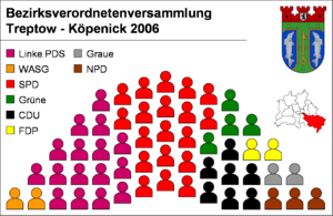
| Parliament of Borough (BVV): | SPD Social Democratic Party of Germany The Social Democratic Party of Germany is a social-democratic political party in Germany... 19, The Left Party.PDS 16, CDU Christian Democratic Union (Germany) The Christian Democratic Union of Germany is a Christian democratic and conservative political party in Germany. It is regarded as on the centre-right of the German political spectrum... 7, Alliance '90/The Greens Alliance '90/The Greens Alliance '90/The Greens is a green political party in Germany, formed from the merger of the German Green Party and Alliance 90 in 1993. Its leaders are Claudia Roth and Cem Özdemir... 4, NPD National Democratic Party of Germany The National Democratic Party of Germany – The People's Union , is a far right German nationalist party. It was founded in 1964 a successor to the German Reich Party . Party statements self-identify as Germany's "only significant patriotic force"... 3, FDP 2, The Greys 2, WASG 2 (last election 2006) |
|
|
||
Berlin
Berlin is the capital city of Germany and is one of the 16 states of Germany. With a population of 3.45 million people, Berlin is Germany's largest city. It is the second most populous city proper and the seventh most populous urban area in the European Union...
, Germany, formed in Berlin's 2001 administrative reform by merging the former boroughs of Treptow
Treptow
Treptow is a former borough in the southeast of Berlin. It merged with Köpenick to form Treptow-Köpenick in 2001.-Geography:The district was composed by the localities of Alt-Treptow, Plänterwald, Baumschulenweg, Niederschöneweide, Johannisthal, Adlershof, Altglienicke and Bohnsdorf....
and Köpenick
Köpenick
Köpenick is a historic town and locality that is situated at the confluence of the rivers Dahme and Spree in the south-east of the German capital city of Berlin. It was formerly known as Copanic and then Cöpenick, only officially adopting the current spelling in 1931...
.
Overview
Among Berlin's boroughs it is the largest by area with the lowest population density. The Johannisthal Air FieldJohannisthal Air Field
The Johannisthal Air Field, located 15 km southeast of Berlin, between Johannisthal and Adlershof, was Germany's first airfield. It opened on 26 September 1909, a few weeks after the world's first airfield at Rheims, France .-Overview:...
lies between Johannisthal
Johannisthal (Berlin)
Johannisthal is a German locality within the Berlin borough of Treptow-Köpenick. Until 2001 it was part of the former borough of Treptow.-History:The first mention of the locality was on November 16, 1753...
and Adlershof
Adlershof
-External links:*...
.
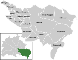
Subdivision
Treptow-Köpenick is divided into 15 localities:- Alt-TreptowAlt-TreptowAlt-Treptow is a German locality in the borough of Treptow-Köpenick in Berlin. Known also as Treptow it was, until 2001, the main and the eponymous locality of the former Treptow borough.-History:...
- PlänterwaldPlänterwaldPlänterwald is a German locality within the Berlin borough of Treptow-Köpenick. Until 2001 it was part of the former borough of Treptow and the site of its former town hall .-History:...
- BaumschulenwegBaumschulenwegBaumschulenweg is a German locality within the Berlin borough of Treptow-Köpenick. Until 2001 it was part of the former borough of Treptow...
- JohannisthalJohannisthal (Berlin)Johannisthal is a German locality within the Berlin borough of Treptow-Köpenick. Until 2001 it was part of the former borough of Treptow.-History:The first mention of the locality was on November 16, 1753...
- NiederschöneweideNiederschöneweideNiederschöneweide is a German locality within the Berlin borough of Treptow-Köpenick. It is, with Oberschöneweide , part of the geographic quarter of Schöneweide...
- AltglienickeAltglienickeAltglienicke is a locality of Berlin in the district of Treptow-Köpenick. Until 2001 it was par of the former borough of Treptow.-History:The village of Glinik was first mentioned in 1375...
- AdlershofAdlershof-External links:*...
- BohnsdorfBohnsdorfBohnsdorf is a district in the borough Treptow-Köpenick of Berlin, Germany. It is located in the south-east of the city.-Position:The locality is situated in the southeastern suburb of Berlin and borders with Altglienicke, Grünau, and with the municipality of Schönefeld, in the Brandenburg district...
- OberschöneweideOberschöneweideOberschöneweide is a German locality within the Berlin borough of Treptow-Köpenick. It is, with Niederschöneweide , part of the geographic area of Schöneweide...
- KöpenickKöpenickKöpenick is a historic town and locality that is situated at the confluence of the rivers Dahme and Spree in the south-east of the German capital city of Berlin. It was formerly known as Copanic and then Cöpenick, only officially adopting the current spelling in 1931...
- FriedrichshagenFriedrichshagenFriedrichshagen is a German locality within the Berlin borough of Treptow-Köpenick. Until 2001 it was part of the former borough of Köpenick.-History:...
- RahnsdorfRahnsdorfRahnsdorf is a German locality within the Berlin borough of Treptow-Köpenick. Until 2001 it was part of the former borough of Köpenick.-History:...
- GrünauGrünau (Berlin)Grünau is a German locality within the Berlin borough of Treptow-Köpenick. Until 2001 it was part of the former borough of Köpenick.-History:...
- MüggelheimMüggelheimMüggelheim is a German locality within the Berlin borough of Treptow-Köpenick. Until 2001 it was part of the former borough of Köpenick.-History:...
- SchmöckwitzSchmöckwitzSchmöckwitz is a German locality within the Berlin borough of Treptow-Köpenick. Until 2001 it was part of the former borough of Köpenick.-History:The locality was founded in 1375 with the name of Smekewitz...
Twin towns
AlbineaAlbinea
Albinea is a comune in the Province of Reggio Emilia in the Italian region Emilia-Romagna, located about 60 km west of Bologna and about 10 km southwest of Reggio nell'Emilia....
, Italy
Italy
Italy , officially the Italian Republic languages]] under the European Charter for Regional or Minority Languages. In each of these, Italy's official name is as follows:;;;;;;;;), is a unitary parliamentary republic in South-Central Europe. To the north it borders France, Switzerland, Austria and...
Cajamarca
Cajamarca
Cajamarca may refer to:Colombia*Cajamarca, Tolima a town and municipality in Tolima DepartmentPeru* Cajamarca, city in Peru.* Cajamarca District, district in the Cajamarca province.* Cajamarca Province, province in the Cajamarca region....
, Peru
Peru
Peru , officially the Republic of Peru , is a country in western South America. It is bordered on the north by Ecuador and Colombia, on the east by Brazil, on the southeast by Bolivia, on the south by Chile, and on the west by the Pacific Ocean....
Cologne
Cologne
Cologne is Germany's fourth-largest city , and is the largest city both in the Germany Federal State of North Rhine-Westphalia and within the Rhine-Ruhr Metropolitan Area, one of the major European metropolitan areas with more than ten million inhabitants.Cologne is located on both sides of the...
, Germany
Germany
Germany , officially the Federal Republic of Germany , is a federal parliamentary republic in Europe. The country consists of 16 states while the capital and largest city is Berlin. Germany covers an area of 357,021 km2 and has a largely temperate seasonal climate...
East Norriton Township
East Norriton Township, Pennsylvania
East Norriton Township is a census-designated place and township in Montgomery County, Pennsylvania, United States. The population was 13,590 at the 2010 census.-Geography:East Norriton Township is located at ....
, United States
United States
The United States of America is a federal constitutional republic comprising fifty states and a federal district...
Izola
Izola
Izola is an old fishing city and a municipality in southwestern Slovenia on the Adriatic coast of the Istrian peninsula. Its name originates from the Italian Isola, which means island.- History :...
, Slovenia
Slovenia
Slovenia , officially the Republic of Slovenia , is a country in Central and Southeastern Europe touching the Alps and bordering the Mediterranean. Slovenia borders Italy to the west, Croatia to the south and east, Hungary to the northeast, and Austria to the north, and also has a small portion of...
Mürzzuschlag
Mürzzuschlag
Mürzzuschlag is a town in northeastern Styria, Austria, the capital of the Mürzzuschlag District. It is located on the Mürz river near the Semmering Pass, the border with the state of Lower Austria, about southwest of Vienna. The population is 8,745...
, Austria
Austria
Austria , officially the Republic of Austria , is a landlocked country of roughly 8.4 million people in Central Europe. It is bordered by the Czech Republic and Germany to the north, Slovakia and Hungary to the east, Slovenia and Italy to the south, and Switzerland and Liechtenstein to the...
Olomouc
Olomouc
Olomouc is a city in Moravia, in the east of the Czech Republic. The city is located on the Morava river and is the ecclesiastical metropolis and historical capital city of Moravia. Nowadays, it is an administrative centre of the Olomouc Region and sixth largest city in the Czech Republic...
, Czech Republic
Czech Republic
The Czech Republic is a landlocked country in Central Europe. The country is bordered by Poland to the northeast, Slovakia to the east, Austria to the south, and Germany to the west and northwest....
Subotica
Subotica
Subotica is a city and municipality in northern Serbia, in the Autonomous Province of Vojvodina...
, Serbia
Serbia
Serbia , officially the Republic of Serbia , is a landlocked country located at the crossroads of Central and Southeast Europe, covering the southern part of the Carpathian basin and the central part of the Balkans...
Veszprém
Veszprém
Veszprém is one of the oldest urban areas in Hungary, and a city with county rights. It lies approximately north of the Lake Balaton. It is the administrative center of the county of the same name.-Location:...
, Hungary
Hungary
Hungary , officially the Republic of Hungary , is a landlocked country in Central Europe. It is situated in the Carpathian Basin and is bordered by Slovakia to the north, Ukraine and Romania to the east, Serbia and Croatia to the south, Slovenia to the southwest and Austria to the west. The...