
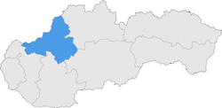
Trencín Region
Encyclopedia
Regions of Slovakia
Since 1949 , Slovakia has been divided into a number of kraje . Their number, borders and functions have been changed several times. There are currently eight regions of Slovakia and they correspond to the EU's NUTS 3 level of local administrative units. Each kraj consists of okresy...
. It consists of 9 districts (okresy
Districts of Slovakia
An okres is an administrative unit in Slovakia. It is inferior to a Region and superior to a municipality.-Characteristics:Several districts form a "Region"...
).
Geography
It is located in the north-western SlovakiaSlovakia
The Slovak Republic is a landlocked state in Central Europe. It has a population of over five million and an area of about . Slovakia is bordered by the Czech Republic and Austria to the west, Poland to the north, Ukraine to the east and Hungary to the south...
, has an area of 4,502 km² and a population of 600,386 (2005). The Danubian Lowland
Danubian Lowland
The Danubian Lowland or Danube Lowland is the name of the part of Little Alföld situated in Slovakia, located between the Danube, the Little Carpathians and all other parts of the Western Carpathians....
reaches the region to Nové Mesto nad Váhom
Nové Mesto nad Váhom
Nové Mesto nad Váhom is a town in the Trenčín Region of Slovakia.- Geography :District town located at the northern edge of the Danubian Hills at the foothills of the northern end of the White Carpathians, on the Váh river. Other mountains nearby are the White Carpathians and the Považský Inovec...
and Partizánske
Partizánske
Partizánske |partisan]] town, formerly: Baťovany) is a town in Trenčín Region, Slovakia.-Geography:It is located in the northern part of the Danubian Hills around from Nitra, on the Nitra River, near the Tribeč mountains.-History:...
areas. There are several mountain ranges in the region: a small part of the Little Carpathians
Little Carpathians
The Little Carpathians are a low, about 100 km long, mountain range, part of the Carpathian Mountains. The mountains are situated in Western Slovakia, covering the area from Bratislava to Nové Mesto nad Váhom, a very small part called Hundsheimer Berge is situated south of Devín Gate in...
in the south-west, White Carpathians
White Carpathians
The White Carpathians is the westernmost mountain range of the Carpathian Mountains.They are part of the Slovak-Moravian Carpathians, stretching from the Váh river and the Little Carpathians in the south along the border between the Czech Republic and Slovakia to the Morava and the Javorníky range...
in the north-west, Javorníky
Javorníky
Maple Mountains is a mountain range of the Slovak-Moravian Carpathians that forms part of the border between the Czech Republic and Slovakia....
in the north, Strážovské vrchy mountains in the centre, Považský Inovec
Považský Inovec
Považský Inovec is a mountain range in western Slovakia, named after the Váh river. It is 48 km long and 15-25 km wide mountain range...
in the south, Vtáčnik
Vtácnik
Vtáčnik is a mountain range in central Slovakia, which is part of the Slovenské stredohorie Mountains and part of the Inner Western Carpathians....
in the south-east and Žiar
Žiar (mountain range)
Žiar is a mountain range in the Trenčín Region of northwestern Slovakia, part of the ranges of the Fatra-Tatra Area of the Inner Western Carpathians....
in the east. Small parts of Lesser Fatra
Lesser Fatra
Lesser Fatra is a mountain range in the Western Carpathians in the north-west of Central Slovakia. In the geomorphological system, it is a part of the Fatra-Tatra Area....
and of the Kremnické vrchy mountains also stretch to the region. Major rivers are the Váh
Váh
The Váh is the longest river in entire Slovakia. A left tributary of the Danube river, the Váh is 406 km long, including its Čierny Váh branch...
in the westerm part of the region, creating so-called Váh Basin and Nitra
Nitra River
The Nitra is a 197 km long river in western Slovakia. It flows into the Váh river close to its confluence with the Danube in Komárno. Its source is in the Malá Fatra mountains north of Prievidza. The river Nitra passes through the towns of Bojnice, Topoľčany, Nitra and Nové Zámky....
in the south-east and east, creating the Upper Nitra Basin. The Myjava River
Myjava River
The Myjava River is a river in western Slovakia and for a small part in the Czech Republic and left tributary of the Morava River.It rises in the White Carpathians near the village of Nová Lhota in Moravia, but crosses the Czech-Slovak border shortly afterwards and flows in a southern direction...
springs in the west, but flows into the Trnava Region. The region borders Žilina Region
Žilina Region
The Žilina Region is one of the eight Slovak administrative regions and consists of 11 districts .-Geography:It is located in northern Slovakia and has an area of 6,804 km² and a population of 694,763 . The whole area is mountainous, belonging to the Western Carpathians...
in the north-east and east, Banská Bystrica Region
Banská Bystrica Region
The Banská Bystrica Region is one of the Slovak regions in the country of Slovakia in Europe.-Geography:It is located in the central part of Slovakia and has an area of 9,455 km². The region is prevailingly mountains, with several ranges within the area. The highest of them are the Low Tatras...
in the south-east, Nitra Region
Nitra Region
The Nitra Region is one of the administrative regions of Slovakia.-Geography:This region with a long history is situated in the southwest of Slovakia, mostly in the eastern part of the Danubian Lowland. It is divided into two sub-units: the Danubian Flat in the south-west, with eastern part of the...
in the south, Trnava Region
Trnava Region
The Trnava Region is one of the eight Slovak administrative regions.-Geography:It is located in the middlewest part of Slovakia and forms a territorial band between the Bratislava Region and the rest of Slovakia, between Austrian and Czech borders in the north and Hungarian border in the south...
in the south and south-west, Czech
Czech Republic
The Czech Republic is a landlocked country in Central Europe. The country is bordered by Poland to the northeast, Slovakia to the east, Austria to the south, and Germany to the west and northwest....
South Moravian Region
South Moravian Region
South Moravian Region is an administrative unit of the Czech Republic, located in the south-western part of its historical region of Moravia, with exception of Jobova Lhota, that belongs to Bohemia. Its capital is Brno the 2nd largest city of the Czech Republic. The region is famous for its wine...
in the west and the Zlín Region
Zlín Region
Zlín Region is an administrative unit of the Czech Republic, located in the central-eastern part of the historical region of Moravia. It is named after its capital Zlín....
in the north-west and north.
Demographics
The population density is 214 inhabitants per km², which is more than Slovak average (110 per km²), and the second highest after the Bratislava RegionBratislava Region
The Bratislava Region is one of the administrative regions of Slovakia. Its capital is Bratislava. It is the smallest of the eight regions of Slovakia.-Geography:...
. The largest towns are Trenčín
Trencín
Trenčín is a city in western Slovakia of the central Váh River valley near the Czech border, around from Bratislava. It has a population of more than 56,000, which makes it the ninth largest municipality of the country and is the seat of the Trenčín Region and the Trenčín District...
, Prievidza
Prievidza
Prievidza is a city in the central-western Slovakia. With 51,200 inhabitants it is one of the biggest municipalities in the Trenčín Region.-Features:...
, Považská Bystrica
Považská Bystrica
Považská Bystrica is a town in northwestern Slovakia. It is located on the Váh river, around 30 km from the city of Žilina. It belongs to Upper Váh region of tourism.- Profile :...
, Dubnica nad Váhom
Dubnica nad Váhom
Dubnica nad Váhom ) is a town in the Ilava District, Trenčín Region in Slovakia.-Geography:It is located on the Váh river, in the Ilava Basin, between the White Carpathians and Strážovské vrchy mountains, at an altitude of 242 metres...
and Partizánske
Partizánske
Partizánske |partisan]] town, formerly: Baťovany) is a town in Trenčín Region, Slovakia.-Geography:It is located in the northern part of the Danubian Hills around from Nitra, on the Nitra River, near the Tribeč mountains.-History:...
. According to the 2001 census, the region had 605,583 inhabitants, with Slovaks
Slovaks
The Slovaks, Slovak people, or Slovakians are a West Slavic people that primarily inhabit Slovakia and speak the Slovak language, which is closely related to the Czech language.Most Slovaks today live within the borders of the independent Slovakia...
forming a relatively homogeneous majority (97.3%), with a small minority of Czechs
Czech people
Czechs, or Czech people are a western Slavic people of Central Europe, living predominantly in the Czech Republic. Small populations of Czechs also live in Slovakia, Austria, the United States, the United Kingdom, Chile, Argentina, Canada, Germany, Russia and other countries...
(1%) and others.
List of districts
- Bánovce nad Bebravou DistrictBánovce nad Bebravou DistrictBánovce nad Bebravou District is adistrict inthe Trenčín Region of western Slovakia.Until 1918, the district was mostly part of theHungarian countyof Trenčín, except for a small...
- Ilava DistrictIlava DistrictIlava District is adistrict inthe Trenčín Region of western Slovakia.Until 1918, the district was part of theHungarian countyof Trenčín.-Municipalities:*Bohunice*Bolešov*Borčice*Červený Kameň*Dubnica nad Váhom*Dulov...
- Myjava DistrictMyjava DistrictMyjava District is adistrict inthe Trenčín Region of western Slovakia.Until 1918, the district was part of theHungarian countyof Nitra.- Municipalities :*Brestovec*Brezová pod Bradlom*Bukovec*Hrašné*Chvojnica*Jablonka...
- Nové Mesto nad Váhom DistrictNové Mesto nad Váhom DistrictNové Mesto nad Váhom District is adistrict inthe Trenčín Region of western Slovakia.Until 1918, the district was mostly part of theHungarian countyof Nitra, with an area in the north...
- Partizánske DistrictPartizánske DistrictPartizánske District is adistrict inthe Trenčín Region of western Slovakia.Until 1918, the district was mostly part of theHungarian countyof Tekov, with an area in the northforming part of the county of Nitra.-Municipalities:...
- Považská Bystrica DistrictPovažská Bystrica DistrictPovažská Bystrica District is adistrict inthe Trenčín Region of western Slovakia.Until 1918, the district was part of theHungarian countyof Trenčín.-Municipalities:*Bodiná*Brvnište*Čelkova Lehota*Dolná Mariková...
- Prievidza DistrictPrievidza DistrictPrievidza District is a district inthe Trenčín Region of western Slovakia.Until 1918, the district was mostly part of the Hungarian county of Nitra, apart from a small area in the south west around Handlová which formed part of the county of...
- Púchov DistrictPúchov DistrictPúchov District is adistrict inthe Trenčín Region of western Slovakia.Until 1918, the district was part of theHungarian countyof Trenčín...
- Trenčín DistrictTrencín DistrictTrenčín District is adistrict inthe Trenčín Region of western Slovakia.Until 1918, the district was part of theHungarian countyof Trenčín.-Municipalities:*Adamovské Kochanovce*Bobot*Dolná Poruba*Dolná Súča*Drietoma*Dubodiel...