

Transport in Mali
Encyclopedia
Mali
Mali , officially the Republic of Mali , is a landlocked country in Western Africa. Mali borders Algeria on the north, Niger on the east, Burkina Faso and the Côte d'Ivoire on the south, Guinea on the south-west, and Senegal and Mauritania on the west. Its size is just over 1,240,000 km² with...
's transportation infrastructure is regarded as poor, even by regional standards, and deficiencies have limited economic growth and development. Nevertheless, improvements have been noted in the early 2000s. A number of road and airport projects were initiated prior to Mali’s hosting of the African Nations Cup football tournament in 2002.
Railways
Mali has only one railroad, including 729 kilometers in Mali, which runs from the port of Koulikoro via Bamako to the border with Senegal and continues on to Dakar. The Bamako-Dakar line, which has been described as dilapidated, is owned by a joint company established by Mali and Senegal in 1995, with the eventual goal of privatization. In 2003 the two countries sold a 25-year concession to run the rail line to a Canadian company, which has pledged to upgrade equipment and infrastructure. The Malian portion of the railroad carried an estimated 536,000 tons of freight and 778,000 passengers in 1999, but the track is in poor condition and the line is closed frequently during the rainy season. The line is potentially significant because it links landlocked Mali to the port of Dakar, increasingly of interest for Malian exports in the face of the disruption of access to Abidjan, Côte d’Ivoire, as a result of civil conflict in that country beginning in late 2002. In the early 2000s, there also were plans to construct a new rail line between Bamako and Kouroussa and Kankan in Guinea.Technical
- GaugeRail gaugeTrack gauge or rail gauge is the distance between the inner sides of the heads of the two load bearing rails that make up a single railway line. Sixty percent of the world's railways use a standard gauge of . Wider gauges are called broad gauge; smaller gauges, narrow gauge. Break-of-gauge refers...
: - BrakesBrake (railway)Brakes are used on the cars of railway trains to enable deceleration, control acceleration or to keep them standing when parked. While the basic principle is familiar from road vehicle usage, operational features are more complex because of the need to control multiple linked carriages and to be...
: The railway uses vacuum brakeVacuum brakeThe vacuum brake is a braking system employed on trains and introduced in the mid-1860s. A variant, the automatic vacuum brake system, became almost universal in British train equipment and in those countries influenced by British practice. Vacuum brakes also enjoyed a brief period of adoption in...
s. - CouplersCoupling (railway)A coupling is a mechanism for connecting rolling stock in a train. The design of the coupler is standard, and is almost as important as the railway gauge, since flexibility and convenience are maximised if all rolling stock can be coupled together.The equipment that connects the couplings to the...
: Buffers and chain, European. - see loco CC2286.
Railway links with adjacent countries
AlgeriaTransport in Algeria
- Railways :There are a total of 3,973 km of railways: 2,888 km is standard gauge, with 283 km of that being electrified and 215 km of that being double tracked...
- no - potential break of gauge / Niger
Transport in Niger
Transport in Niger is crucial to the economy of this vast landlocked nation, with cities separated by huge uninhabited deserts, mountain ranges, and other natural features. A poor nation, Niger's transport system was little developed during the colonial period , relying upon animal transport,...
- no railways Burkina Faso
Transport in Burkina Faso
This article concerns the systems of transport in Burkina Faso, which primarily include road and rail infrastructure.- Railways :There are 622 kilometres of railway in Burkina Faso, of which 517 km run from Ouagadougou to Abidjan, Côte d'Ivoire; and 105 km from Ouagadougou to Kaya. All...
- no - same gauge Côte d'Ivoire
Transport in Côte d'Ivoire
- Railways :As of 2004, the nation’s railway system consisted of a state-controlled 660 km section of a 1,146 km narrow gauge railroad that ran north from Abidjan through Bouaké and Ferkéssédougou to Ouagadougou, Burkina Faso.total:660 km...
- no - same gauge Guinea
Transport in Guinea
- Railways :total:1,086 kmstandard gauge:279 km gaugemetre gauge:807 km gauge The lines do not all connect.- Northern line :...
- no - same gauge also Senegal
Transport in Senegal
- Railways :total: 906 kmnarrow gauge: 906 km of gauge - Maps :* * - Ground transport :There were an estimated 4,271 km of paved roads and 10,305 km of unpaved roads as of 1996....
- yes - same gauge Mauritania
Transport in Mauritania
- Railways :*717 km total of single track , owned and operated by a government mining company, Société Nationale Industrielle et Minière...
- no - break of gauge /
Maps
Existing
- DakarDakarDakar is the capital city and largest city of Senegal. It is located on the Cap-Vert Peninsula on the Atlantic coast and is the westernmost city on the African mainland...
, SenegalSenegalSenegal , officially the Republic of Senegal , is a country in western Africa. It owes its name to the Sénégal River that borders it to the east and north...
- port - ThiesThièsThiès is the third largest city in Senegal with a population officially estimated at 320,000 in 2005. It lies 60 km east of Dakar on the N2 road and at the junction of railway lines to Dakar, Bamako and St-Louis...
, SenegalSenegalSenegal , officially the Republic of Senegal , is a country in western Africa. It owes its name to the Sénégal River that borders it to the east and north...
- junction; workships - DiourbelDiourbelDiourbel is a town in Senegal lying east of Thiès. It is known for its mosque and local groundnut industry. It is the capital of the Diourbel Region. Estimated population 2007: 100,445- Transport :...
, SenegalSenegalSenegal , officially the Republic of Senegal , is a country in western Africa. It owes its name to the Sénégal River that borders it to the east and north... - GuinguinéoGuinguinéoGuinguinéo is a city in the center of Senegal, situated in 22 kilometers to the northeast of Kaolack. Its history is an indisputable fame, Before 1956, Guinguinéo crossed the phenomenon of kingdoms piloted by the succession of several kings whose most famous is Fodé DIOUF. Guinguinéo became a...
, SenegalSenegalSenegal , officially the Republic of Senegal , is a country in western Africa. It owes its name to the Sénégal River that borders it to the east and north... - KaffrineKaffrineKaffrine is the capital town of Kaffrine Region of Senegal....
, SenegalSenegalSenegal , officially the Republic of Senegal , is a country in western Africa. It owes its name to the Sénégal River that borders it to the east and north... - TambacoundaTambacoundaTambacounda is the largest city in eastern Senegal, southeast of Dakar, and is the Regional capital of the province of the same name. Its estimated population in 2007 was 78,800.-Geography:...
, SenegalSenegalSenegal , officially the Republic of Senegal , is a country in western Africa. It owes its name to the Sénégal River that borders it to the east and north... - KidiraKidira- Transport :It is an important transport hub and lies on the N1 and N2 roads, the Dakar – Bamako railway and the Falémé River....
, SenegalSenegalSenegal , officially the Republic of Senegal , is a country in western Africa. It owes its name to the Sénégal River that borders it to the east and north...
- MaliMaliMali , officially the Republic of Mali , is a landlocked country in Western Africa. Mali borders Algeria on the north, Niger on the east, Burkina Faso and the Côte d'Ivoire on the south, Guinea on the south-west, and Senegal and Mauritania on the west. Its size is just over 1,240,000 km² with...
border - KayesKayesKayes is a city in western Mali on the Sénégal River, with a population of roughly 100,000 people. Kayes is the capital of the administrative region of the same name. The name "Kayes" comes from the Soninké word "karré", which describes a low humid place that floods in rainy season...
, MaliMaliMali , officially the Republic of Mali , is a landlocked country in Western Africa. Mali borders Algeria on the north, Niger on the east, Burkina Faso and the Côte d'Ivoire on the south, Guinea on the south-west, and Senegal and Mauritania on the west. Its size is just over 1,240,000 km² with... - DiamouDiamouDiamou is a town and commune in the Cercle of Kayes in the Kayes Region of south-western Mali. It is located 45 km from Kayes city. As of 1998 the commune had a population of 12,255. Telephone services are available for residents of the town....
, MaliMaliMali , officially the Republic of Mali , is a landlocked country in Western Africa. Mali borders Algeria on the north, Niger on the east, Burkina Faso and the Côte d'Ivoire on the south, Guinea on the south-west, and Senegal and Mauritania on the west. Its size is just over 1,240,000 km² with... - KitaKita-People:* Ikki Kita, Japanese philosopher* Hideki Kita , Japanese long-distance runner.* Michal Kita, Polish mixed martial artist* Kita, the stage name of Sampsa Astala, a member of the Finnish band Lordi...
, MaliMaliMali , officially the Republic of Mali , is a landlocked country in Western Africa. Mali borders Algeria on the north, Niger on the east, Burkina Faso and the Côte d'Ivoire on the south, Guinea on the south-west, and Senegal and Mauritania on the west. Its size is just over 1,240,000 km² with... - KatiKatiKati is a town made up of 37 communes in Mali's Koulikoro Region, about 15 km from Bamako, Mali's capital. It has a population of approximately 40,000 inhabitants.-Economy:...
, MaliMaliMali , officially the Republic of Mali , is a landlocked country in Western Africa. Mali borders Algeria on the north, Niger on the east, Burkina Faso and the Côte d'Ivoire on the south, Guinea on the south-west, and Senegal and Mauritania on the west. Its size is just over 1,240,000 km² with... - BamakoBamakoBamako is the capital of Mali and its largest city with a population of 1.8 million . Currently, it is estimated to be the fastest growing city in Africa and sixth fastest in the world...
- national capital - KoulikoroKoulikoroKoulikoro is a city in Mali. The capital of the Koulikoro Region, Koulikoro is located on banks of the Niger River, from Mali's capital Bamako....
- railheadRailheadThe word railhead is a railway term with two distinct meanings, depending upon its context.Sometimes, particularly in the context of modern freight terminals, the word is used to denote a terminus of a railway line, especially if the line is not yet finished, or if the terminus interfaces with...
and river port.
Highways
Abidjan
Abidjan is the economic and former official capital of Côte d'Ivoire, while the current capital is Yamoussoukro. it was the largest city in the nation and the third-largest French-speaking city in the world, after Paris, and Kinshasa but before Montreal...
in Côte d’Ivoire. The European Development Fund
European Development Fund
The European Development Fund is the main instrument for European Union aid for development cooperation in Africa, the Caribbean, and Pacific countries and the Overseas Countries and Territories...
is financing
construction of a road linking Bamako and Dakar
Dakar
Dakar is the capital city and largest city of Senegal. It is located on the Cap-Vert Peninsula on the Atlantic coast and is the westernmost city on the African mainland...
, Senegal
Senegal
Senegal , officially the Republic of Senegal , is a country in western Africa. It owes its name to the Sénégal River that borders it to the east and north...
. The African Development Bank
African Development Bank
The African Development Bank Group is a development bank established in 1964 with the intention of promoting economic and social development in Africa...
is funding the construction of a road linking Bamako and Kankan
Kankan
Kankan is the largest city in Guinea in land area, and the third largest in population at 207,790 . The city is located on the Milo River in eastern Guinea and lying about 345 miles east of Conakry....
in Guinea
Guinea
Guinea , officially the Republic of Guinea , is a country in West Africa. Formerly known as French Guinea , it is today sometimes called Guinea-Conakry to distinguish it from its neighbour Guinea-Bissau. Guinea is divided into eight administrative regions and subdivided into thirty-three prefectures...
. There are also plans for a trans-Saharan road linking Mali with Algeria
Algeria
Algeria , officially the People's Democratic Republic of Algeria , also formally referred to as the Democratic and Popular Republic of Algeria, is a country in the Maghreb region of Northwest Africa with Algiers as its capital.In terms of land area, it is the largest country in Africa and the Arab...
. In general, road conditions outside of urban areas are hazardous, especially at night. Because of isolation, poor road conditions, and the prevalence of banditry, overland travel to the north of Mali is regarded as especially dangerous; flying or traveling by boat is reported to be preferable where possible. Many of Mali’s major thoroughfares in the north are little more than desert tracks with long isolated stretches.
Urban transport
Because rate of automobile ownership is low, and formal government run public transit is sparse, informal buses and taxis abound in Malian urban centers. BamakoBamako
Bamako is the capital of Mali and its largest city with a population of 1.8 million . Currently, it is estimated to be the fastest growing city in Africa and sixth fastest in the world...
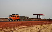
in particular is known for its green and yellow taxi fleet. Other vehicles, including trucks, buses, motorcycles and mini-vans, function as taxis. In recent years small motorcycles, imported from China and most lacking licenses, have come to dominate much of Bamako's traffic. Inexpensive motorbikes are often the only affordable transport in Mali, with Chinese made bikes selling for $700 USD. While the government formally requires licensing for both motorcycles and their operators, these rules are largely ignored. Some 500,000 motorcycles were estimated to be operating in Mali in 2009, with two thirds of them inexpensive Chinese made cycles, known locally as "Jakarta"s, which boast better fuel economy but fewer safety features than more expensive Japanese or Western brands. In the 1990s, Bamako banned horse carts, which caused an increase in hand carts on the streets. Recent road construction has included separated lanes for two wheeled (carts, bicycles, motorcycles), four wheeled, and pedestrian traffic.
Road fatalities
Motor vehicle accidents are relatively common on Mali's roads. The Malian Equipment and Transport Ministry reported that the first half of 2008 saw 254 deaths and 1,924 injuries on Mali's roads, following on 579 deaths in 2007 and 642 in 2006. The government has pledged 15 billion CFAF in 2009 to fund road safety, and has pledged to create a national road security agency to control highway traffic.Barriers to transport
While police control barriers are a common sight on African highways, and while illicit demands for bribes at such stops are common in many countries, the main Malian highway heading south from BamakoBamako
Bamako is the capital of Mali and its largest city with a population of 1.8 million . Currently, it is estimated to be the fastest growing city in Africa and sixth fastest in the world...
to the Burkina Faso
Burkina Faso
Burkina Faso – also known by its short-form name Burkina – is a landlocked country in west Africa. It is surrounded by six countries: Mali to the north, Niger to the east, Benin to the southeast, Togo and Ghana to the south, and Côte d'Ivoire to the southwest.Its size is with an estimated...
border was singled out in late 2008 as the worst in West Africa. A survey by the Observatory of Abnormal Practices (OPA) of the West African Economic and Monetary Union (WAEMU) found the Malian section of this road to have the highest number of police roadblocks with the highest average amount paid in bribes per trip in West Africa. An average of twenty-nine roadblocks, almost 4 for every 100 km, were reported from June to September 2008. The amount paid in bribes in the Mali section (per trip) was CFA F 31,509. While in other nations the customs officials were responsible for most stops, in Mali, gendarmerie
Gendarmerie
A gendarmerie or gendarmery is a military force charged with police duties among civilian populations. Members of such a force are typically called "gendarmes". The Shorter Oxford English Dictionary describes a gendarme as "a soldier who is employed on police duties" and a "gendarmery, -erie" as...
(National paramilitary police) and the Police force were found creating the majority of bribe extorting roadblocks. The number of roadblocks on the Bamako-Burkina highway also increased by 12 per cent during the third quarter of 2008, going from 67 to 75.
Ports and waterways
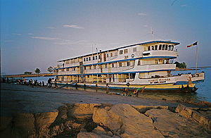
Koulikoro
Koulikoro is a city in Mali. The capital of the Koulikoro Region, Koulikoro is located on banks of the Niger River, from Mali's capital Bamako....
on the Niger River near Bamako, serves as a principal river port. Traditionally, Abidjan in Côte d’Ivoire has been Mali’s main seaport, handling as much as 70 percent of Mali’s trade (except for gold exports). Mali’s export trade suffered when turbulence in Côte d’Ivoire in the early 2000s interrupted that trade route.
Mali has 1,815 kilometers of inland waterways, principally the Niger River, some portions of which are navigable for medium and large shipping during the rainy season (June/July–November/December) in years of normal rainfall. Parts of the Senegal River also are navigable, providing year-round access to the Atlantic from Kayes to St. Louis in Senegal.
Aviation
In 2007 Mali reportedly had 29 airports, 8 of which had paved runways. The main airport is Senou International AirportSenou International Airport
-Accidents and incidents:*On 24 July 1971, Douglas C-47A 6V-AAP of Air Ivoire crashed into a hill shortly after take-off. The aircraft was operating a scheduled passenger flight. All six people on board were killed.-Traffic and statistics:...
in Bamako, which offers flights to neighboring countries and to Europe. As part of infrastructure improvements in 2002, the runway at Bamako was extended, and new airstrips were built in previously isolated areas of the west—Kayes, Mopti, and Sikasso. Air Mali was liquidated in April 2003, but intercontinental services from Bamako are provided by Air France and a Belgian airline, among others.