

Transport in Afghanistan
Encyclopedia
Transportation in Afghanistan, which serves a population of about 29 million people
, is limited and still in the developing stages. Landlocked Afghanistan
has no seaports but the Amu Darya
(Oxus) River, which forms part of the nation's border with Turkmenistan
, Uzbekistan
, and Tajikistan
, does have barge traffic. Rebuilding of airports, roads, and a railway line has led to rapid economic boost in the country in the last five years. Much of Afghanistan's road network was built during the 1960s. New national highways, roads, and bridges have been rebuilt in recent years to help increase travel as well as trade with neighboring countries. The nation has about 53 airports, which have been built within the last 50 years.
 Most major roads were built in the 1960s, by the United States
and the Soviet Union. The Soviets built a road and tunnel
through the Salang pass in 1964, connecting northern and southern Afghanistan. A highway connecting the principal cities of Herat
, Kandahar
, Ghazni
, and Kabul
with links to highways in neighboring Pakistan
formed the primary road system.
The network includes 12,350 kilometers of paved roads and 29,800 kilometers of unpaved roads, for an approximate total road system of 42,150 kilometers as of 2006.
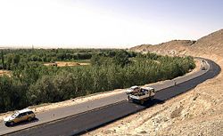 The highway system is currently going through a total reconstruction phase. Most of the regional roads are also being repaired or improved. For the last 30 years, the poor state of the Afghan transportation and communication networks have further fragmented and hampered the struggling economy.
Since the fall of the Taliban many roads have been rebuilt, including the following:
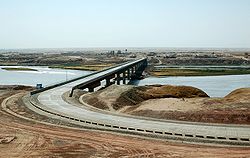
A road bridge linking Tajikistan and Afghanistan which cost $37 million was inaugurated in 2007. The bridge, nearly 700 metres long and 11 metres across, straddles the Panj river
which forms a natural border between the two countries, between the ports of Nizhny Panj on the Tajik side and Shir Khan Bandar
in Afghanistan. The Delaram-Zaranj highway was constructed with India
n assistance and was inaugurated in January 2009.
service between Uzbekistan
and the northern Afghan city of Mazar-i-Sharif, all of which is built to broad gauge
. The line begins from Termez
and crosses the Amu Darya river on the Soviet
-built Afghanistan–Uzbekistan Friendship Bridge
, finally reaching a site next to the Mazar-i-Sharif Airport. The Afghan government expects to have the rail line extended to Kabul
and then to the eastern border town of Torkham
, connecting with Pakistan Railways
. The work is carried out by China Metallurgical Group Corporation
(MCC) and is expected to be completed by 2014. For strategic reasons
, past Afghan governments preferred to discourage the construction of railways which could aid foreign interference in Afghanistan by Britain
or Russia.
in Turkmenistan to the town of Towraghondi
in Afghanistan. An upgrade of this Soviet-built line began in 2007.
in Iran is a standard gauge
line which terminates at Mashhad
. This line is being extended 191 kilometers east to Herat
, of which 77 km is located inside Iran and the remaining 114 km in Afghanistan.
in Balochistan
near the Khojak Pass
; and at Torkham, the border town
near the Khyber Pass
. Various proposals exist to extend these lines on to Kandahar
and Kabul
respectively. In July 2010, Pakistan and Afghanistan signed a Memorandum of understanding
for going ahead with the laying of rail tracks
between the two countries. Work on the proposed project was set to start in late 2010.
or Tajikistan, though a connection to the latter was proposed in 2008.
pipelines
from Bagram
into Uzbekistan and Shindand
into Turkmenistan. These pipelines have been in disrepair and disuse for years. There are 180 kilometers of natural gas pipelines. The $3 billion Trans-Afghanistan Pipeline
proposal for a natural gas pipeline across Afghanistan into Pakistan is moving forward.
.
, and by several private companies such as Kam Air
, Pamir Airways, and Safi Airways
. Airlines from a number of nations also provide air services to fly in and out of the country.
The nation has approximately 53 airports, about 19 of these have paved runways. Of those, 4 have runways over 3,000 meters, 3 have runways between about 2,500 and 3,000 meters, 8 have runways between 1500 and 2500 meters, and 2 has a runway under 1000 meters. About 34 have unpaved runways. Of those, 5 have runways between 2500 and 3000 meters, 14 have runways between 1500 and 2500 meters, 6 have runways between 1000 and 1500 meters, and 9 have runways under 1000 meters.
Bagram Air Base
is used by the US military and allied forces. It has heavy traffic, especially helicopters. It can also handle larger airliners such as Boeing 747
s, C-5 Galaxy
and C-17 Globemaster III
military cargo planes. KBR
and some other companies fly into and out of Bagram on a regular basis.
Afghanistan government priorities include upgrading of Kabul Airport to international airport meeting ICAO standards and upgrading Herat, Mazari Sharif and Jalalabad airports to international standards.
Demography of Afghanistan
The population of Afghanistan is around 29,835,392 as of the year 2011, which is unclear if the refugees living outside the country are included or not. The nation is composed of a multi-ethnic and multi-lingual society, reflecting its location astride historic trade and invasion routes between...
, is limited and still in the developing stages. Landlocked Afghanistan
Afghanistan
Afghanistan , officially the Islamic Republic of Afghanistan, is a landlocked country located in the centre of Asia, forming South Asia, Central Asia and the Middle East. With a population of about 29 million, it has an area of , making it the 42nd most populous and 41st largest nation in the world...
has no seaports but the Amu Darya
Amu Darya
The Amu Darya , also called Oxus and Amu River, is a major river in Central Asia. It is formed by the junction of the Vakhsh and Panj rivers...
(Oxus) River, which forms part of the nation's border with Turkmenistan
Turkmenistan
Turkmenistan , formerly also known as Turkmenia is one of the Turkic states in Central Asia. Until 1991, it was a constituent republic of the Soviet Union, the Turkmen Soviet Socialist Republic . Turkmenistan is one of the six independent Turkic states...
, Uzbekistan
Uzbekistan
Uzbekistan , officially the Republic of Uzbekistan is a doubly landlocked country in Central Asia and one of the six independent Turkic states. It shares borders with Kazakhstan to the west and to the north, Kyrgyzstan and Tajikistan to the east, and Afghanistan and Turkmenistan to the south....
, and Tajikistan
Tajikistan
Tajikistan , officially the Republic of Tajikistan , is a mountainous landlocked country in Central Asia. Afghanistan borders it to the south, Uzbekistan to the west, Kyrgyzstan to the north, and China to the east....
, does have barge traffic. Rebuilding of airports, roads, and a railway line has led to rapid economic boost in the country in the last five years. Much of Afghanistan's road network was built during the 1960s. New national highways, roads, and bridges have been rebuilt in recent years to help increase travel as well as trade with neighboring countries. The nation has about 53 airports, which have been built within the last 50 years.
Highways
United States
The United States of America is a federal constitutional republic comprising fifty states and a federal district...
and the Soviet Union. The Soviets built a road and tunnel
Salang tunnel
The Salang Tunnel , located in Parwan province, is a link between northern and southern Afghanistan crossing the Hindukush mountain range under the difficult Salang Pass....
through the Salang pass in 1964, connecting northern and southern Afghanistan. A highway connecting the principal cities of Herat
Herat
Herāt is the capital of Herat province in Afghanistan. It is the third largest city of Afghanistan, with a population of about 397,456 as of 2006. It is situated in the valley of the Hari River, which flows from the mountains of central Afghanistan to the Karakum Desert in Turkmenistan...
, Kandahar
Kandahar
Kandahar is the second largest city in Afghanistan, with a population of about 512,200 as of 2011. It is the capital of Kandahar Province, located in the south of the country at about 1,005 m above sea level...
, Ghazni
Ghazni
For the Province of Ghazni see Ghazni ProvinceGhazni is a city in central-east Afghanistan with a population of about 141,000 people...
, and Kabul
Kabul
Kabul , spelt Caubul in some classic literatures, is the capital and largest city of Afghanistan. It is also the capital of the Kabul Province, located in the eastern section of Afghanistan...
with links to highways in neighboring Pakistan
Pakistan
Pakistan , officially the Islamic Republic of Pakistan is a sovereign state in South Asia. It has a coastline along the Arabian Sea and the Gulf of Oman in the south and is bordered by Afghanistan and Iran in the west, India in the east and China in the far northeast. In the north, Tajikistan...
formed the primary road system.
The network includes 12,350 kilometers of paved roads and 29,800 kilometers of unpaved roads, for an approximate total road system of 42,150 kilometers as of 2006.
Major highways
Since the fall of the Taliban many roads have been rebuilt, including the following:
- Kabul-Kandahar HighwayKabul-Kandahar highwayThe Kabul-Kandahar Highway is a road linking Afghanistan's two largest cities, Kabul and Kandahar. This highway is a key portion of Afghanistan's national road system or "Ring Road"...
- Kabul-Jalalabad-Torkham Highway
- Kabul-Gardez Highway
- Kabul-Mazar Highway
- Kandahar-Boldak Highway
- Kandahar-Herat HighwayKandahar-Herat HighwayThe Kandahar-Herat Highway is road that links the cities of Kandahar and Herat in Afghanistan. This highway is part of a larger road network, the "Ring Road", and was first constructed by the Soviets in the 1960s....
- Herat-Islam Qala Highway
- Herat-Mazar Highway
- Route TridentRoute TridentRoute Trident was built by the British Army's Royal Engineers in Helmand Province, Afghanistan. The construction of the road was codenamed Operation Lar Jarowel by the Ministry of Defence...
(Lashkar Gah to GereshkGereshkGereshk is a town in Gerishk District in Helmand province on the Helmand River in central Afghanistan, some northwest of Kandahar at 817 m altitude. Gereshk is the centre of a rich agricultural region with the Kajakai dam upriver diverting water to the Boghra Irrigation Canal. Gereshk was...
) - Delaram-Zaranj Highway
A road bridge linking Tajikistan and Afghanistan which cost $37 million was inaugurated in 2007. The bridge, nearly 700 metres long and 11 metres across, straddles the Panj river
Panj River
The Panj River , also known as Pyandzh River or Piandj River , is a tributary of the Amu Darya. The river is 1,125 km long and forms a considerable part of the Afghanistan - Tajikistan border....
which forms a natural border between the two countries, between the ports of Nizhny Panj on the Tajik side and Shir Khan Bandar
Shir Khan Bandar
Shir Khan Bandar is a port on the Panj River in Afghanistan on the border with Tajikistan. Its old name was Qezel Qal‘eh. It was renamed after Shir Khan Nashir, Khan of the Kharoti tribe, governor of Kunduz and the rest of northern Afghanistan in the 1930s.- Transport :It is currently served via a...
in Afghanistan. The Delaram-Zaranj highway was constructed with India
India
India , officially the Republic of India , is a country in South Asia. It is the seventh-largest country by geographical area, the second-most populous country with over 1.2 billion people, and the most populous democracy in the world...
n assistance and was inaugurated in January 2009.
Railways
There is a 75 kilometres railwayRail transport
Rail transport is a means of conveyance of passengers and goods by way of wheeled vehicles running on rail tracks. In contrast to road transport, where vehicles merely run on a prepared surface, rail vehicles are also directionally guided by the tracks they run on...
service between Uzbekistan
Uzbekistan
Uzbekistan , officially the Republic of Uzbekistan is a doubly landlocked country in Central Asia and one of the six independent Turkic states. It shares borders with Kazakhstan to the west and to the north, Kyrgyzstan and Tajikistan to the east, and Afghanistan and Turkmenistan to the south....
and the northern Afghan city of Mazar-i-Sharif, all of which is built to broad gauge
Russian gauge
In railway terminology, Russian gauge refers to railway track with a gauge between 1,520 mm and . In a narrow sense as defined by Russian Railways it refers to gauge....
. The line begins from Termez
Termez
Termez is a city in southern Uzbekistan near the border with Afghanistan.Some link the name of the city to thermos, "hot" in Greek, tracing its name back to Alexander the Great. Others suggest that it came from Sanskrit taramato, meaning "on the river bank". It is the hottest point of Uzbekistan...
and crosses the Amu Darya river on the Soviet
Soviet Union
The Soviet Union , officially the Union of Soviet Socialist Republics , was a constitutionally socialist state that existed in Eurasia between 1922 and 1991....
-built Afghanistan–Uzbekistan Friendship Bridge
Afghanistan–Uzbekistan Friendship Bridge
The Afghanistan–Uzbekistan Friendship Bridge is a road and rail bridge across the river Amu Darya in the northern Balkh province of Afghanistan, which connects the town of Hairatan with Termez in Uzbekistan...
, finally reaching a site next to the Mazar-i-Sharif Airport. The Afghan government expects to have the rail line extended to Kabul
Kabul
Kabul , spelt Caubul in some classic literatures, is the capital and largest city of Afghanistan. It is also the capital of the Kabul Province, located in the eastern section of Afghanistan...
and then to the eastern border town of Torkham
Torkham
Torkham is a border crossing town in the Nangarhar province of Afghanistan and the Khyber Agency of Pakistan's Federally Administered Tribal Areas, right on the Durand Line border....
, connecting with Pakistan Railways
Pakistan Railways
This article is about the rail company in Pakistan. For technical details and operations see: Transport in Pakistan.Pakistan Railways is a national state-owned rail transport service of Pakistan, head-quartered in Lahore. It is administered by the federal government under the Ministry of Railways....
. The work is carried out by China Metallurgical Group Corporation
China Metallurgical Group Corporation
China Metallurgical Group Corporation , , is a state-owned enterprise in Beijing, China, engaging in EPC , natural resources exploitation, papermaking, equipment fabrication, real estate development...
(MCC) and is expected to be completed by 2014. For strategic reasons
The Great Game
The Great Game or Tournament of Shadows in Russia, were terms for the strategic rivalry and conflict between the British Empire and the Russian Empire for supremacy in Central Asia. The classic Great Game period is generally regarded as running approximately from the Russo-Persian Treaty of 1813...
, past Afghan governments preferred to discourage the construction of railways which could aid foreign interference in Afghanistan by Britain
British Empire
The British Empire comprised the dominions, colonies, protectorates, mandates and other territories ruled or administered by the United Kingdom. It originated with the overseas colonies and trading posts established by England in the late 16th and early 17th centuries. At its height, it was the...
or Russia.
Turkmenistan border
A 10 kilometer long 1,520 mm (4 ft 11+5⁄6 in) gauge line extends from SerhetabatSerhetabat
Serhetabat is a small town in the Mary Province in Turkmenistan, located in the valley of the Kushka River. Population: 5,200 ....
in Turkmenistan to the town of Towraghondi
Towraghondi
Towraghondi is a border town in Afghanistan. It is immediately opposite Serhetabat in Turkmenistan, with which it is connected by a road and a 1520 mm gauge railway which was restored to use in 2007.- See also :*Islam Qala*Hairatan...
in Afghanistan. An upgrade of this Soviet-built line began in 2007.
Iranian border
The nearest railheadRailhead
The word railhead is a railway term with two distinct meanings, depending upon its context.Sometimes, particularly in the context of modern freight terminals, the word is used to denote a terminus of a railway line, especially if the line is not yet finished, or if the terminus interfaces with...
in Iran is a standard gauge
Standard gauge
The standard gauge is a widely-used track gauge . Approximately 60% of the world's existing railway lines are built to this gauge...
line which terminates at Mashhad
Mashhad
Mashhad , is the second largest city in Iran and one of the holiest cities in the Shia Muslim world. It is also the only major Iranian city with an Arabic name. It is located east of Tehran, at the center of the Razavi Khorasan Province close to the borders of Afghanistan and Turkmenistan. Its...
. This line is being extended 191 kilometers east to Herat
Herat
Herāt is the capital of Herat province in Afghanistan. It is the third largest city of Afghanistan, with a population of about 397,456 as of 2006. It is situated in the valley of the Hari River, which flows from the mountains of central Afghanistan to the Karakum Desert in Turkmenistan...
, of which 77 km is located inside Iran and the remaining 114 km in Afghanistan.
Pakistan border
Two broad gauge Pakistan Railways lines terminate near the border at ChamanChaman
Chaman is the capital of Qilla Abdullah District, Balochistan, Pakistan. It is situated just south of the border with Afghanistan. Across the border in Afghanistan is the neighbouring town of Spin Boldak, in Kandahar Province...
in Balochistan
Balochistan (Pakistan)
Balochistan is one of the four provinces or federating units of Pakistan. With an area of 134,051 mi2 or , it is the largest province of Pakistan, constituting approximately 44% of the total land mass of Pakistan. According to the 1998 population census, Balochistan had a population of...
near the Khojak Pass
Khojak Pass
Khojak Pass connects Qila Abdullah with Chaman in the province of Baluchistan, Pakistan.* Khojak Pass is between Quetta and Chaman...
; and at Torkham, the border town
Border town
A border town is a town or city close to the boundary between two countries, states or regions. Usually the term implies that it is one of the things the town is most famous for. Border towns can have highly cosmopolitan communities, a feature they share with port cities...
near the Khyber Pass
Khyber Pass
The Khyber Pass, is a mountain pass linking Pakistan and Afghanistan.The Pass was an integral part of the ancient Silk Road. It is mentioned in the Bible as the "Pesh Habor," and it is one of the oldest known passes in the world....
. Various proposals exist to extend these lines on to Kandahar
Kandahar
Kandahar is the second largest city in Afghanistan, with a population of about 512,200 as of 2011. It is the capital of Kandahar Province, located in the south of the country at about 1,005 m above sea level...
and Kabul
Kabul
Kabul , spelt Caubul in some classic literatures, is the capital and largest city of Afghanistan. It is also the capital of the Kabul Province, located in the eastern section of Afghanistan...
respectively. In July 2010, Pakistan and Afghanistan signed a Memorandum of understanding
Memorandum of understanding
A memorandum of understanding is a document describing a bilateral or multilateral agreement between parties. It expresses a convergence of will between the parties, indicating an intended common line of action. It is often used in cases where parties either do not imply a legal commitment or in...
for going ahead with the laying of rail tracks
Rail tracks
The track on a railway or railroad, also known as the permanent way, is the structure consisting of the rails, fasteners, sleepers and ballast , plus the underlying subgrade...
between the two countries. Work on the proposed project was set to start in late 2010.
Other borders
There are no rail links to ChinaTransportation in China
Transport in China may refer to:*Transport in the People's Republic of China *Transport in Hong Kong*Transport in Macau*Transportation in Taiwan...
or Tajikistan, though a connection to the latter was proposed in 2008.
Pipelines
There are petroleumPetroleum
Petroleum or crude oil is a naturally occurring, flammable liquid consisting of a complex mixture of hydrocarbons of various molecular weights and other liquid organic compounds, that are found in geologic formations beneath the Earth's surface. Petroleum is recovered mostly through oil drilling...
pipelines
Pipeline transport
Pipeline transport is the transportation of goods through a pipe. Most commonly, liquids and gases are sent, but pneumatic tubes that transport solid capsules using compressed air are also used....
from Bagram
Bagram
Bagram , founded as Alexandria on the Caucasus and known in medieval times as Kapisa, is a small town and seat in Bagram District in Parwan Province of Afghanistan, about 60 kilometers north of the capital Kabul. It is the site of an ancient city located at the junction of the Ghorband and Panjshir...
into Uzbekistan and Shindand
Shindand
Shindand may refer to:*Shindand, Herat, Afghanistan**Shindand Air Base, north of the city*Shindand, Farah, Afghanistan*Shindand, Pakistan, village in FATA, Pakistan...
into Turkmenistan. These pipelines have been in disrepair and disuse for years. There are 180 kilometers of natural gas pipelines. The $3 billion Trans-Afghanistan Pipeline
Trans-Afghanistan Pipeline
The Trans-Afghanistan Pipeline is a proposed natural gas pipeline being developed by the Asian Development Bank. The pipeline will transport Caspian Sea natural gas from Turkmenistan through Afghanistan into Pakistan and then to India. The abbreviation comes from the first letters of those...
proposal for a natural gas pipeline across Afghanistan into Pakistan is moving forward.
Ports and harbors
The chief inland waterway of land-locked Afghanistan is the Amu Darya River which forms part of Afghanistan's northern border. The river handles barge traffic up to about 500 metric tons. The main river ports are located at Kheyrabad and Shir Khan BandarShir Khan Bandar
Shir Khan Bandar is a port on the Panj River in Afghanistan on the border with Tajikistan. Its old name was Qezel Qal‘eh. It was renamed after Shir Khan Nashir, Khan of the Kharoti tribe, governor of Kunduz and the rest of northern Afghanistan in the 1930s.- Transport :It is currently served via a...
.
Air transport
Air transport in Afghanistan is provided by the national carrier Ariana Afghan AirlinesAriana Afghan Airlines
Ariana Afghan Airlines Co. Ltd. is the oldest and the national airline of Afghanistan, and is currently the largest Afghan airline, headquartered in Kabul...
, and by several private companies such as Kam Air
Kam Air
Kam Air is an airline headquartered in the Kabul Business Centre in Shah-e-Naw, Kabul, Afghanistan. It operates scheduled domestic passenger services and international services to the Middle East and several Asian republics...
, Pamir Airways, and Safi Airways
Safi Airways
Safi Airways Co. is an Afghan airline. The airline Safi Airways - IATA-Code 4Q - was founded in 2006 by Abdul Qudos Safi, an Afghan Businessman...
. Airlines from a number of nations also provide air services to fly in and out of the country.
The nation has approximately 53 airports, about 19 of these have paved runways. Of those, 4 have runways over 3,000 meters, 3 have runways between about 2,500 and 3,000 meters, 8 have runways between 1500 and 2500 meters, and 2 has a runway under 1000 meters. About 34 have unpaved runways. Of those, 5 have runways between 2500 and 3000 meters, 14 have runways between 1500 and 2500 meters, 6 have runways between 1000 and 1500 meters, and 9 have runways under 1000 meters.
- Kabul International AirportKabul International Airport-Facilities:The airport has two terminal buildings, the modern for international flights and the Soviet built one for domestic flights. Several hangars along the runway are for military aircraft...
(3500 m runway) is the nation's largest airport and the primary hub for international civilian flights. - Kandahar International Airport (3200 m runway) is a dual-use airport serving southern Afghanistan.
- Mazari Sharif AirportMazari Sharif AirportMazar-i-Sharif Airport is located 9 km east of the Mazar-i-Sharif city, a journey of 15 minutes by taxi.-ISAF:Germany took command of the International Security Assistance Force’s Regional Area North at the end of March 2006...
(3100 m runway) is a dual-use airport serving the northern and central portions of the country. - Herat Airport (2600 m runway) is the primary civil airport for the western portion of the country.
- Jalalabad AirportJalalabad Airport-External links:*...
(1800 m runway)
Bagram Air Base
Bagram Air Base
Bagram Airfield, also referred to as Bagram Air Base, is a militarized airport and housing complex that is located next to the ancient city of Bagram, southeast of Charikar in Parwan province of Afghanistan. The base is run by a US Army division headed by a major general. A large part of the base,...
is used by the US military and allied forces. It has heavy traffic, especially helicopters. It can also handle larger airliners such as Boeing 747
Boeing 747
The Boeing 747 is a wide-body commercial airliner and cargo transport, often referred to by its original nickname, Jumbo Jet, or Queen of the Skies. It is among the world's most recognizable aircraft, and was the first wide-body ever produced...
s, C-5 Galaxy
C-5 Galaxy
The Lockheed C-5 Galaxy is a large military transport aircraft built by Lockheed. It provides the United States Air Force with a heavy intercontinental-range strategic airlift capability, one that can carry outsize and oversize cargos, including all air-certifiable cargo. The Galaxy has many...
and C-17 Globemaster III
C-17 Globemaster III
The Boeing C-17 Globemaster III is a large military transport aircraft. Developed for the United States Air Force from the 1980s to the early 1990s by McDonnell Douglas, the C-17 is used for rapid strategic airlift of troops and cargo to main operating bases or forward operating bases throughout...
military cargo planes. KBR
Kellogg, Brown and Root
KBR, Inc. is an American engineering, construction and private military contracting company, formerly a subsidiary of Halliburton, headquartered in Houston. The company also has large offices in Arlington, Birmingham, Newark, Delaware and Leatherhead, UK. After Halliburton acquired Dresser...
and some other companies fly into and out of Bagram on a regular basis.
Afghanistan government priorities include upgrading of Kabul Airport to international airport meeting ICAO standards and upgrading Herat, Mazari Sharif and Jalalabad airports to international standards.