

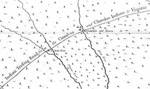
Trading Path
Encyclopedia
Chesapeake Bay
The Chesapeake Bay is the largest estuary in the United States. It lies off the Atlantic Ocean, surrounded by Maryland and Virginia. The Chesapeake Bay's drainage basin covers in the District of Columbia and parts of six states: New York, Pennsylvania, Delaware, Maryland, Virginia, and West...
region (mainly the Petersburg, Virginia
Petersburg, Virginia
Petersburg is an independent city in Virginia, United States located on the Appomattox River and south of the state capital city of Richmond. The city's population was 32,420 as of 2010, predominantly of African-American ethnicity...
area) and the Cherokee
Cherokee
The Cherokee are a Native American people historically settled in the Southeastern United States . Linguistically, they are part of the Iroquoian language family...
, Catawba
Catawba
Catawba may refer to several things:*Catawba , a Native American tribe*Catawban languages-Botany:*Catalpa, a genus of trees, based on the name used by the Catawba and other Native American tribes*Catawba , a variety of grape...
, and other Native-American groups in the Piedmont region of North Carolina
North Carolina
North Carolina is a state located in the southeastern United States. The state borders South Carolina and Georgia to the south, Tennessee to the west and Virginia to the north. North Carolina contains 100 counties. Its capital is Raleigh, and its largest city is Charlotte...
, South Carolina
South Carolina
South Carolina is a state in the Deep South of the United States that borders Georgia to the south, North Carolina to the north, and the Atlantic Ocean to the east. Originally part of the Province of Carolina, the Province of South Carolina was one of the 13 colonies that declared independence...
, and Georgia
Georgia (U.S. state)
Georgia is a state located in the southeastern United States. It was established in 1732, the last of the original Thirteen Colonies. The state is named after King George II of Great Britain. Georgia was the fourth state to ratify the United States Constitution, on January 2, 1788...
. Indians had used and maintained much of the path for their expansive trading network centuries prior to its use by Europeans and/or European-Americans. Indian and later European/European-American settlements occupied key points along the path.
Both Natives and Newcomers mainly used the Trading Path for commercial cargo carriage. In early colonial times, Virginian traders
Fur trade
The fur trade is a worldwide industry dealing in the acquisition and sale of animal fur. Since the establishment of world market for in the early modern period furs of boreal, polar and cold temperate mammalian animals have been the most valued...
used the path to travel to Native American towns in the Waxhaws. They led long pack caravans of horses carrying "loads of guns, gunpowder, knives, jewelry, blankets, and hatchets, among other goods", and travel southwest to Indian villages along the journey to the Waxhaws
Waxhaws
The Waxhaws is a geographical area on the border of North and South Carolina.-Geography:The Waxhaws region is in the Piedmont region of North and South Carolina, southwest of the Uwharrie Mountains. The region encompasses an area just south of Charlotte, North Carolina, to Lancaster, South...
region, in the vicinity of present-day Mecklenburg County
Mecklenburg County
Mecklenburg County is the name of two counties in the United States:* Mecklenburg County, North Carolina* Mecklenburg County, Virginia...
. They exchanged European goods for furs and deerskins
Deerskin trade
The deerskin trade between Colonial America and the Native Americans was one of the most important trading relationships between Europeans and Native Americans, especially in the southeast. It was a form of the fur trade, but less known, since deer skins were not as valuable as furs from the north...
.
Because the path was well laid out through the complex geography of the piedmont area, connecting fords of many streams, it was roughly followed by the 19th-century railroad. Later, engineers who designed Interstate 85
Interstate 85
Interstate 85 is a major interstate highway in the Southeastern United States. Its current southern terminus is at an interchange with Interstate 65 in Montgomery, Alabama; its northern terminus interchanges with Interstate 95 in Petersburg, Virginia, near Richmond...
followed much of this route again from Petersburg, VA, to roughly the Georgia state border. Many of the earliest towns along its route remain to this day. Many remnants of the Trading Path are still visible.
The Trading Path underlies the Piedmont Urban Crescent
Piedmont Crescent
The Piedmont Crescent, also known as the Piedmont Urban Crescent, is a large, polycentric urbanized region in the U.S. state of North Carolina that forms the northern section of the rapidly developing I-85 Corridor megalopolis in the southeastern United States...
, which since the late 19th century has had steady growth. It is a spine of polycentric urban development in North Carolina. Cities of the Crescent are the centers of government, finance, education and research, and business in the state.