
Topologically Integrated Geographic Encoding and Referencing
Encyclopedia
United States Census Bureau
The United States Census Bureau is the government agency that is responsible for the United States Census. It also gathers other national demographic and economic data...
to describe land attributes such as roads, buildings, rivers, and lakes, as well as areas such as census tracts. TIGER was developed to support and improve the Bureau's process of taking the Decennial Census
United States Census
The United States Census is a decennial census mandated by the United States Constitution. The population is enumerated every 10 years and the results are used to allocate Congressional seats , electoral votes, and government program funding. The United States Census Bureau The United States Census...
.
The TIGER files do not contain the census demographic data, but merely the map data. GIS can be used to merge census demographics or other data sources with the TIGER files to create maps and conduct analysis. TIGER data is available without cost because U.S. Government publications
Work of the United States Government
A work of the United States government, as defined by United States copyright law, is "a work prepared by an officer or employee of the U.S. government as part of that person's official duties." The term only applies to the work of the federal government, including the governments of "non-organized...
are required to be released into the public domain
Public domain
Works are in the public domain if the intellectual property rights have expired, if the intellectual property rights are forfeited, or if they are not covered by intellectual property rights at all...
.
Development and maintenance
United States Census, 1960
The Eighteenth United States Census, conducted by the Census Bureau, determined the resident population of the United States to be 179,323,175, an increase of 18.5 percent over the 151,325,798 persons enumerated during the 1950 Census.-Census questions:...
, the Census Bureau had enumerators visit each household in the United States to have them fill out a questionnaire. The Census Bureau provided enumerators with maps, showing the assigned area to canvass. In the late 1960s, the United States Census Bureau developed Dual Independent Map Encoding
Dual Independent Map Encoding
Dual Independent Map Encoding is an encoding scheme developed by the US Bureau of the Census for efficiently storing geographical data. The committee behind the case study that eventually resulted in DIME was established in 1965, although the term DIME itself was first coined by George Farnsworth...
(DIME), a geographic information system to handle spatial data. DIME was superseded in the 1980s, with development of TIGER, which addressed problems encountered during the 1980 census with maps and geographic classifications. TIGER first used with the 1990 census.
All aspects of TIGER, including the data model
Data model
A data model in software engineering is an abstract model, that documents and organizes the business data for communication between team members and is used as a plan for developing applications, specifically how data is stored and accessed....
, data structure
Data structure
In computer science, a data structure is a particular way of storing and organizing data in a computer so that it can be used efficiently.Different kinds of data structures are suited to different kinds of applications, and some are highly specialized to specific tasks...
, user interface
User interface
The user interface, in the industrial design field of human–machine interaction, is the space where interaction between humans and machines occurs. The goal of interaction between a human and a machine at the user interface is effective operation and control of the machine, and feedback from the...
, software applications, and map creation process, were developed in-house by Census Bureau staff, along with help from the USGS. Hydrography
Hydrography
Hydrography is the measurement of the depths, the tides and currents of a body of water and establishment of the sea, river or lake bed topography and morphology. Normally and historically for the purpose of charting a body of water for the safe navigation of shipping...
, railroads
Rail transport
Rail transport is a means of conveyance of passengers and goods by way of wheeled vehicles running on rail tracks. In contrast to road transport, where vehicles merely run on a prepared surface, rail vehicles are also directionally guided by the tracks they run on...
, and other features were scanned or digitized from USGS topographic map
Topographic map
A topographic map is a type of map characterized by large-scale detail and quantitative representation of relief, usually using contour lines in modern mapping, but historically using a variety of methods. Traditional definitions require a topographic map to show both natural and man-made features...
s (1:100,000 scale), vertically and horizontally integrated, then combined with updated addressing data from DIME and topology added. The process was largely automated with use of batch processing
Batch processing
Batch processing is execution of a series of programs on a computer without manual intervention.Batch jobs are set up so they can be run to completion without manual intervention, so all input data is preselected through scripts or command-line parameters...
, though a dedicated staff manually digitized from 1:24,000 scale annotated USGS maps to make updates to early TIGER during its construction in the late 1980's.
TIGER defines geographic areas and features using topology
Geospatial topology
Geospatial topology studies the rules concerning the relationships between the points, lines, and polygons that represent the features of a geographic region. For example, where two polygons represent adjacent counties, typical topological rules would require that the counties share a common...
, to represent the relationships between such features on a map. TIGER enables geocoding
Geocoding
Geocoding is the process of finding associated geographic coordinates from other geographic data, such as street addresses, or zip codes...
of street address
Address (geography)
An address is a collection of information, presented in a mostly fixed format, used for describing the location of a building, apartment, or other structure or a plot of land, generally using political boundaries and street names as references, along with other identifiers such as house or...
es. However, because of temporal changes and typographical errors such as missing directionals and feature attributes, this can result in poor or incorrect matches in some areas. While the TIGER database itself models linear features and political and statistical geography, it is also linked topologically to the Census Bureau's Master Address File (MAF). The MAF and TIGER together (MAF/TIGER) are used to locate all data for purposes of collecting and tabulating the census. The Census Bureau receives a Delivery Sequence File (DSF) from the US Postal Service semi-annually and it is by use of this and select monthly field surveys that it locates new and problem addresses in MAF/TIGER. The Census Bureau also mails annual Boundary and Annexation Survey (BAS) maps to tribal, municipal, and county governments to allow them a chance to update or correct boundaries and/or linework that may be in error in TIGER. A few years before each decennial census, the Census Bureau administers a program known as the Local Update of Census Addresses (LUCA) in which it allows political jurisdictions to improve its MAF/TIGER by submitting address lists and local GIS data for inclusion in the Census.
Coverage
The TIGER/Line shapefile data includes complete coverage of the United StatesUnited States
The United States of America is a federal constitutional republic comprising fifty states and a federal district...
, Puerto Rico
Puerto Rico
Puerto Rico , officially the Commonwealth of Puerto Rico , is an unincorporated territory of the United States, located in the northeastern Caribbean, east of the Dominican Republic and west of both the United States Virgin Islands and the British Virgin Islands.Puerto Rico comprises an...
, the U.S. Virgin Islands, American Samoa
American Samoa
American Samoa is an unincorporated territory of the United States located in the South Pacific Ocean, southeast of the sovereign state of Samoa...
, Guam
Guam
Guam is an organized, unincorporated territory of the United States located in the western Pacific Ocean. It is one of five U.S. territories with an established civilian government. Guam is listed as one of 16 Non-Self-Governing Territories by the Special Committee on Decolonization of the United...
, the Commonwealth of the Northern Mariana Islands, and the Midway Islands.
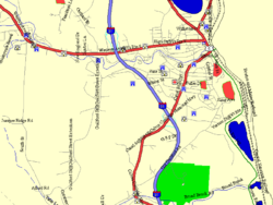
TIGER includes both land attributes such as roads, buildings, rivers, and lakes, as well as areas such as counties, census tracts, and census blocks. Some of the geographic areas represented in TIGER are political areas, including state and federally recognized tribal lands, cities, counties, congressional districts, and school districts. Others are statistical areas, including Metropolitan Statistical Areas (MSA), census tracts, census block groups, and census blocks. ZIP Code Tabulation Areas (ZCTA) are quasi-statistical areas which attempt to approximate, but are by no means the same as, the USPS ZIP code
ZIP Code
ZIP codes are a system of postal codes used by the United States Postal Service since 1963. The term ZIP, an acronym for Zone Improvement Plan, is properly written in capital letters and was chosen to suggest that the mail travels more efficiently, and therefore more quickly, when senders use the...
s. ZIP codes are not truly areas, but rather a range of deliverable addresses. Some or all of a ZIP's addresses may be reassigned to another ZIP. As many as 3% of ZIP codes undergo change each quarter. Thus, the 5-digit ZCTAs are of limited value over the long term.
Future
TIGER data published through February 2007 (2006 Second Edition) were in a custom text-based format formally known as TIGER/LineTM files. In 2008, data in shapefileShapefile
The Esri Shapefile or simply a shapefile is a popular geospatial vector data format for geographic information systems software. It is developed and regulated by Esri as a open specification for data interoperability among Esri and other software products.Shapefiles spatially describe geometries:...
format was published. Future editions will be available for download in GML
Geography Markup Language
The Geography Markup Language is the XML grammar defined by the Open Geospatial Consortium to express geographical features. GML serves as a modeling language for geographic systems as well as an open interchange format for geographic transactions on the Internet...
. The Census Bureau will also make the data available through WFS
Web Feature Service
The Open Geospatial Consortium Web Feature Service Interface Standard provides an interface allowing requests for geographical features across the web using platform-independent calls...
and WMS
Web Map Service
A Web Map Service is a standard protocol for serving georeferenced map images over the Internet that are generated by a map server using data from a GIS database...
servers. The data forms a base for OpenStreetMap
OpenStreetMap
OpenStreetMap is a collaborative project to create a free editable map of the world. Two major driving forces behind the establishment and growth of OSM have been restrictions on use or availability of map information across much of the world and the advent of inexpensive portable GPS devices.The...
in the USA.