
Tomalá
Encyclopedia
Tomalá is a municipality
in the Honduran
department of Lempira.
 Tomalá is one of the smallest municipalities of the Lempira department in Honduras
. It is situated 10 minutes away from Tambla
municipality.
district.
-San Marcos de Ocotepeque-Cololaca-Tambla. It takes about 2 hr, the road up to Cololaca
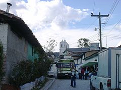
is being paved, but once one passes Cololaca the road is in very good conditions. This town will sure a very pleasant visit for the traveler, because it is located at a very quite and nice place, with many Pine forests and magnificent views to other mountain ranges, especially "Congolón". The parades and holidays are very crowded for their entertainment and "showy". The people are very welcoming and nice as well. Its church is dated 1904, and they take good care of it. It looks like time never passes by in this place.
Municipality
A municipality is essentially an urban administrative division having corporate status and usually powers of self-government. It can also be used to mean the governing body of a municipality. A municipality is a general-purpose administrative subdivision, as opposed to a special-purpose district...
in the Honduran
Honduras
Honduras is a republic in Central America. It was previously known as Spanish Honduras to differentiate it from British Honduras, which became the modern-day state of Belize...
department of Lempira.
Honduras
Honduras is a republic in Central America. It was previously known as Spanish Honduras to differentiate it from British Honduras, which became the modern-day state of Belize...
. It is situated 10 minutes away from Tambla
Tambla
Tambla is a municipality in the Honduran department of Lempira.Tambla is one of the municipalities of the Lempira department. In order to arrive to its municipality capital is better to go via Santa Rosa de Copán-San Marcos de Ocotepeque-Cololaca-Tambla.- History :At the beginning it was located at...
municipality.
History
It started as a small village back in 1576. Since it was originally located on a swamp, the community decided to relocate it onto the toe of a hill, and it has been there ever since. In the census of 1791 it was a town belonging to "Curato de Sensenti" and in 1889 it was a municipality of GuaritaGuarita
Guarita is a municipality in the Honduran department of Lempira.Guarita is one of the oldest municipalities of the Lempira department. The best way to go to Guarita is via Santa Rosa de Copán-San Marcos de Ocotepeque-Cololaca-Guarita and it takes about 2.5 hours. This way is much more preferable...
district.
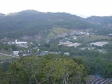
Geography
It is situated at the top of a mountain. There are also huge mountains around the municipality capital. All of these are covered with Pine forests. The weather is very cool along the year, except for the summer because it increases a little.Boundaries
Its boundaries are:- North : San SebastiánSan Sebastian, LempiraSan Sebastian is a municipality in the Honduran department of Lempira.San Sebastián is one of the farthest municipalities of the Lempira department. It is 13 km ahead of San Manuel Colohete. It is highly recommended to go on a 4 wheel drive vehicle when visiting this municipality.- History :In the...
municipality. - South : TamblaTamblaTambla is a municipality in the Honduran department of Lempira.Tambla is one of the municipalities of the Lempira department. In order to arrive to its municipality capital is better to go via Santa Rosa de Copán-San Marcos de Ocotepeque-Cololaca-Tambla.- History :At the beginning it was located at...
municipality. - East : San AndrésSan Andrés, LempiraSan Andrés is a municipality in the Honduran department of Lempira. It is notable as the principal site in Honduras for the mining of andesite opals from Las Colinas deposit near Sosoal, which is in the municipality. This mining is largely performed by artisanal miners, rather than on an industrial...
municipality. - West : TamblaTamblaTambla is a municipality in the Honduran department of Lempira.Tambla is one of the municipalities of the Lempira department. In order to arrive to its municipality capital is better to go via Santa Rosa de Copán-San Marcos de Ocotepeque-Cololaca-Tambla.- History :At the beginning it was located at...
municipality.
- Surface Extents: 48 km² (19 sq mi)
Resources
It is one more of the municipalities proper for coffee plantation. Obviously they take advantadge of the elevation from sea level. The next activity is raising cattle followed by beans and corn crops. The commerce is a very important economical activity as well. As the rest of the department it has electricity in the municipality capital and mobile communications coverage.Population
In Tomalá the cross-breed of Spanish and Indians represent 80 % of the people. The rest is take by Indians descendants who live in the villages around the municipality capital.- Population: the figure was 5,032 people back in 2001, for the year of 2008 the figure is expected to increase up to 6,124.
- Villages: 13
- Settlements: 33
Tourism
In order to arrive to its municipality capital is better to go via Santa Rosa de CopánSanta Rosa de Copán
Santa Rosa de Copán is the departmental capital of the Honduran department of Copán. It is set at an elevation of approximately above mean sea level....
-San Marcos de Ocotepeque-Cololaca-Tambla. It takes about 2 hr, the road up to Cololaca
Cololaca
Cololaca is a municipality in the Honduran department of Lempira.Cololaca is one of the municipalities of the Lempira department. It is located more than 200 km away from Gracias. There is also an alternate way to go there, and that is taking a deviation in San Marcos de Ocotepeque. Taking this...
is being paved, but once one passes Cololaca the road is in very good conditions. This town will sure a very pleasant visit for the traveler, because it is located at a very quite and nice place, with many Pine forests and magnificent views to other mountain ranges, especially "Congolón". The parades and holidays are very crowded for their entertainment and "showy". The people are very welcoming and nice as well. Its church is dated 1904, and they take good care of it. It looks like time never passes by in this place.
- Local Holidays: "San Francisco de Asis" day on October 4th and "Inmaculada Concepción" day on December 8th.
External links