
Tivoli, New York
Encyclopedia
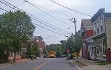
Tivoli is a village
in Dutchess County, New York
, United States
. The population was 1,118 at the 2010 census. The village, which was incorporated in 1872 from parts of Upper Red Hook Landing and Madalin, is the northernmost settlement in the county, located in the northwest part of the Town of Red Hook
. It is part of the Poughkeepsie
–Newburgh
–Middletown
, NY Metropolitan Statistical Area
as well as the larger New York
–Newark
–Bridgeport
, NY-NJ
-CT
-PA
Combined Statistical Area
. It is also entirely within the Hudson River Historic District
, a National Historic Landmark
. The village is accessible via New York State Route 9G
at an intersection with Dutchess County Route 78.
A private liberal arts college, Bard College
, is located just south of the village, and the Kaatsbaan International Dance Center is located within the village boundaries.
.
According to the United States Census Bureau
, the village has a total area of 1.8 square miles (4.7 km²), of which, 1.8 square miles (4.7 km²) of it is land and 0.04 square mile (0.1035995244 km²) of it (1.68%) is water.
- is known as Broadway, Route 78 within the village. CR 78 ends at the Hudson River
. At one time a ferry crossed the Hudson River
from here to Saugerties
in Ulster County
. The second highway, New York State Route 9G
, runs along the village border and has an intersection with CR 78.
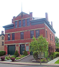 The government of Tivoli is made up of five elected officials, who meet at the Watts dePeyster Hall
. The hall is part of the village municipal campus, and contains the village offices. The current elected officials in Tivoli are:
of 2000, there were 1,163 people, 487 households, and 261 families residing in the village. The population density
was 662.1 people per square mile (255.1/km²). There were 531 housing units at an average density of 302.3 per square mile (116.5/km²). The racial makeup of the village was 95.70% White, 0.43% African American, 0.17% Native American, 0.95% Asian, 0.69% from other races
, and 2.06% from two or more races. Hispanic or Latino of any race were 2.92% of the population.
There were 487 households out of which 30.0% had children under the age of 18 living with them, 40.7% were married couples
living together, 9.4% had a female householder with no husband present, and 46.4% were non-families. 31.4% of all households were made up of individuals and 8.0% had someone living alone who was 65 years of age or older. The average household size was 2.38 and the average family size was 3.10.
In the village the population was spread out with 23.8% under the age of 18, 16.8% from 18 to 24, 28.7% from 25 to 44, 20.5% from 45 to 64, and 10.2% who were 65 years of age or older. The median age was 34 years. For every 100 females there were 84.6 males. For every 100 females age 18 and over, there were 79.4 males.
The median income for a household in the village was $40,536, and the median income for a family was $53,393. Males had a median income of $41,375 versus $26,000 for females. The per capita income
for the village was $20,478. About 6.2% of families and 17.5% of the population were below the poverty line, including 11.9% of those under age 18 and 3.8% of those age 65 or over.
Village
A village is a clustered human settlement or community, larger than a hamlet with the population ranging from a few hundred to a few thousand , Though often located in rural areas, the term urban village is also applied to certain urban neighbourhoods, such as the West Village in Manhattan, New...
in Dutchess County, New York
Dutchess County, New York
Dutchess County is a county located in the U.S. state of New York, in the state's Mid-Hudson Region of the Hudson Valley. The 2010 census lists the population as 297,488...
, United States
United States
The United States of America is a federal constitutional republic comprising fifty states and a federal district...
. The population was 1,118 at the 2010 census. The village, which was incorporated in 1872 from parts of Upper Red Hook Landing and Madalin, is the northernmost settlement in the county, located in the northwest part of the Town of Red Hook
Red Hook, New York
Red Hook is a town in Dutchess County, New York, United States. The population was reported to be 11,319 during the 2010 census. The name is supposedly derived from the red foliage on trees on a small strip of land on the Hudson River. The town contains two villages; the village of Red Hook and the...
. It is part of the Poughkeepsie
Poughkeepsie (city), New York
Poughkeepsie is a city in the state of New York, United States, which serves as the county seat of Dutchess County. Poughkeepsie is located in the Hudson River Valley midway between New York City and Albany...
–Newburgh
Newburgh (city), New York
Newburgh is a city located in Orange County, New York, United States, north of New York City, and south of Albany, on the Hudson River. Newburgh is a principal city of the Poughkeepsie-Newburgh-Middletown metropolitan area, which includes all of Dutchess and Orange counties. The Newburgh area was...
–Middletown
Middletown, Orange County, New York
Middletown is a city in Orange County, New York, United States. It lies in New York's Hudson Valley region, near the Wallkill River and the foothills of the Shawangunk Mountains. Middletown is situated between Port Jervis and Newburgh, New York. The city's population was 25,388 at the 2000 census...
, NY Metropolitan Statistical Area
Poughkeepsie-Newburgh-Middletown metropolitan area
The Poughkeepsie–Newburgh–Middletown Metropolitan Statistical Area, as defined by the United States Census Bureau, is an area consisting of two counties in New York's Hudson Valley, with the cities of Poughkeepsie, Newburgh, and Middletown, and the Arlington census-designated place as...
as well as the larger New York
New York City
New York is the most populous city in the United States and the center of the New York Metropolitan Area, one of the most populous metropolitan areas in the world. New York exerts a significant impact upon global commerce, finance, media, art, fashion, research, technology, education, and...
–Newark
Newark, New Jersey
Newark is the largest city in the American state of New Jersey, and the seat of Essex County. As of the 2010 United States Census, Newark had a population of 277,140, maintaining its status as the largest municipality in New Jersey. It is the 68th largest city in the U.S...
–Bridgeport
Bridgeport, Connecticut
Bridgeport is the most populous city in the U.S. state of Connecticut. Located in Fairfield County, the city had an estimated population of 144,229 at the 2010 United States Census and is the core of the Greater Bridgeport area...
, NY-NJ
New Jersey
New Jersey is a state in the Northeastern and Middle Atlantic regions of the United States. , its population was 8,791,894. It is bordered on the north and east by the state of New York, on the southeast and south by the Atlantic Ocean, on the west by Pennsylvania and on the southwest by Delaware...
-CT
Connecticut
Connecticut is a state in the New England region of the northeastern United States. It is bordered by Rhode Island to the east, Massachusetts to the north, and the state of New York to the west and the south .Connecticut is named for the Connecticut River, the major U.S. river that approximately...
-PA
Pennsylvania
The Commonwealth of Pennsylvania is a U.S. state that is located in the Northeastern and Mid-Atlantic regions of the United States. The state borders Delaware and Maryland to the south, West Virginia to the southwest, Ohio to the west, New York and Ontario, Canada, to the north, and New Jersey to...
Combined Statistical Area
New York metropolitan area
The New York metropolitan area, also known as Greater New York, or the Tri-State area, is the region that composes of New York City and the surrounding region...
. It is also entirely within the Hudson River Historic District
Hudson River Historic District
The Hudson River Historic District, also known as Hudson River Heritage Historic District, is the largest such district on the mainland of the contiguous United States...
, a National Historic Landmark
National Historic Landmark
A National Historic Landmark is a building, site, structure, object, or district, that is officially recognized by the United States government for its historical significance...
. The village is accessible via New York State Route 9G
New York State Route 9G
New York State Route 9G is a state highway in the Hudson Valley of New York in the United States. It runs north from U.S. Route 9 at Poughkeepsie, starting out as Violet Avenue, then follows the Hudson River mostly along the eastern side of the US 9 to Rhinebeck, where the two...
at an intersection with Dutchess County Route 78.
A private liberal arts college, Bard College
Bard College
Bard College, founded in 1860 as "St. Stephen's College", is a small four-year liberal arts college located in Annandale-on-Hudson, New York.-Location:...
, is located just south of the village, and the Kaatsbaan International Dance Center is located within the village boundaries.
History
The region was part of the Schuyler Patent, a 1788 patent defining some of the towns and villages in Dutchess County and the Poughkeepsie Regional Area. The village was formerly known as "Upper Red Hook Landing." An adjacent community, "Madalin," was contiguous to Upper Red Hook Landing. The Village of Tivoli was incorporated in 1872, consolidating both Madalin and Upper Red Hook Landing. The village government sits in an old firehouse which was constructed by General John Watts de PeysterJohn Watts de Peyster
John Watts de Peyster, Sr. was an author on the art of war, philanthropist, and early Adjutant General of the New York National Guard. He served in the New York State Militia during the Mexican-American War and American Civil War...
.
Geography
Tivoli is located at 42°3′34"N 73°54′38"W (42.059370, -73.910663).According to the United States Census Bureau
United States Census Bureau
The United States Census Bureau is the government agency that is responsible for the United States Census. It also gathers other national demographic and economic data...
, the village has a total area of 1.8 square miles (4.7 km²), of which, 1.8 square miles (4.7 km²) of it is land and 0.04 square mile (0.1035995244 km²) of it (1.68%) is water.
Major roads
There are two major highways that traverse Tivoli. County Route 78 - formerly New York State Route 402New York State Route 402
New York State Route 402 was a state highway located within the village of Tivoli in Dutchess County, New York, United States. It was assigned in the early 1930s and served as a connector between NY 9G and what was once a ferry landing on the Hudson River west of the village...
- is known as Broadway, Route 78 within the village. CR 78 ends at the Hudson River
Hudson River
The Hudson is a river that flows from north to south through eastern New York. The highest official source is at Lake Tear of the Clouds, on the slopes of Mount Marcy in the Adirondack Mountains. The river itself officially begins in Henderson Lake in Newcomb, New York...
. At one time a ferry crossed the Hudson River
Hudson River
The Hudson is a river that flows from north to south through eastern New York. The highest official source is at Lake Tear of the Clouds, on the slopes of Mount Marcy in the Adirondack Mountains. The river itself officially begins in Henderson Lake in Newcomb, New York...
from here to Saugerties
Saugerties (village), New York
Saugerties is a village in Ulster County, New York, USA. The population was 4,955 at the 2000 census.The Village of Saugerties is a Town in the eastern part of the Town of Saugerties. U.S. Route 9W passes through the village...
in Ulster County
Ulster County, New York
Ulster County is a county located in the state of New York, USA. It sits in the state's Mid-Hudson Region of the Hudson Valley. As of the 2010 census, the population was 182,493. Recent population estimates completed by the United States Census Bureau for the 12-month period ending July 1 are at...
. The second highway, New York State Route 9G
New York State Route 9G
New York State Route 9G is a state highway in the Hudson Valley of New York in the United States. It runs north from U.S. Route 9 at Poughkeepsie, starting out as Violet Avenue, then follows the Hudson River mostly along the eastern side of the US 9 to Rhinebeck, where the two...
, runs along the village border and has an intersection with CR 78.
Government
Watts De Peyster Fireman's Hall
The Watts De Peyster Fireman's Hall is located on Broadway in the village of Tivoli, New York, United States. John Watts De Peyster, a resident, paid for it and gave it to the village for its fire department in 1898...
. The hall is part of the village municipal campus, and contains the village offices. The current elected officials in Tivoli are:
| Elected position | Current official |
|---|---|
| Mayor | Bryan F. Cranna |
| Deputy Mayor | Michael S. Leedy |
| Trustees | Susan Ezrati, Robin Bruno, Joel Griffith |
Demographics
As of the censusCensus
A census is the procedure of systematically acquiring and recording information about the members of a given population. It is a regularly occurring and official count of a particular population. The term is used mostly in connection with national population and housing censuses; other common...
of 2000, there were 1,163 people, 487 households, and 261 families residing in the village. The population density
Population density
Population density is a measurement of population per unit area or unit volume. It is frequently applied to living organisms, and particularly to humans...
was 662.1 people per square mile (255.1/km²). There were 531 housing units at an average density of 302.3 per square mile (116.5/km²). The racial makeup of the village was 95.70% White, 0.43% African American, 0.17% Native American, 0.95% Asian, 0.69% from other races
Race (United States Census)
Race and ethnicity in the United States Census, as defined by the Federal Office of Management and Budget and the United States Census Bureau, are self-identification data items in which residents choose the race or races with which they most closely identify, and indicate whether or not they are...
, and 2.06% from two or more races. Hispanic or Latino of any race were 2.92% of the population.
There were 487 households out of which 30.0% had children under the age of 18 living with them, 40.7% were married couples
Marriage
Marriage is a social union or legal contract between people that creates kinship. It is an institution in which interpersonal relationships, usually intimate and sexual, are acknowledged in a variety of ways, depending on the culture or subculture in which it is found...
living together, 9.4% had a female householder with no husband present, and 46.4% were non-families. 31.4% of all households were made up of individuals and 8.0% had someone living alone who was 65 years of age or older. The average household size was 2.38 and the average family size was 3.10.
In the village the population was spread out with 23.8% under the age of 18, 16.8% from 18 to 24, 28.7% from 25 to 44, 20.5% from 45 to 64, and 10.2% who were 65 years of age or older. The median age was 34 years. For every 100 females there were 84.6 males. For every 100 females age 18 and over, there were 79.4 males.
The median income for a household in the village was $40,536, and the median income for a family was $53,393. Males had a median income of $41,375 versus $26,000 for females. The per capita income
Per capita income
Per capita income or income per person is a measure of mean income within an economic aggregate, such as a country or city. It is calculated by taking a measure of all sources of income in the aggregate and dividing it by the total population...
for the village was $20,478. About 6.2% of families and 17.5% of the population were below the poverty line, including 11.9% of those under age 18 and 3.8% of those age 65 or over.