

Tirari Desert
Encyclopedia
The Tirari Desert is a 15250 square kilometres (5,888 sq mi) desert
in the eastern part of the Far North
region of South Australia
.
It is located partly within the Lake Eyre National Park
. It lies mainly to the east of Lake Eyre
North. Cooper Creek
runs through the centre of the desert.
The adjacent deserts of the area include Simpson Desert
which lies to the north while the Strzelecki Desert
is to the east and the Sturt Stony Desert runs aligned with the Birdsville track to the north east.
The desert experiences harsh conditions with high temperatures and very low rainfall (mean annual rainfall is below 125 millimetres (4.9 in)).
which runs northwards from Marree
to Birdsville
. The Mungerannie Hotel is the only location between the two towns that provides services.
The Tirari Desert region has a number of large cattle station
s which are stopping points on the Channel Country
aviation mail run.
Dulkaninna Station has been run by the same family for 110 years, has 2000 cattle and breeds horses and kelpie
s. Etadunna Station to the north is a 1 million acres (4,046.9 km²) cattle station
with 2500 cattle.
The station environs include a number of heritage sites include Bucaltaninna Homestead ruins, the Woolshed ruins and Canny Trig Point
(also known as Milner's Pile) and the state heritage-registered Killalpaninna Mission site.
Further north again is Mulka Station which also has a number of heritage sites including homestead ruins at Apatoongannie, Old Mulka and Ooroowillannie. The Mulka Store ruins is listed on the South Australian state register of heritage places.
 The vegetation of the dunefields of the Tirari Desert is dominated by either Sandhill Wattle (Acacia ligulata) or Sandhill Cane-grass (Zygochloa paradoxa) which occur on the crests and slopes of dunes. Tall, open shrubland also occurs on the slopes. The otherwise sparsely vegetated dunefields become covered by a carpet of grasses, herbs and colourful flowering plant
s following rains.
The interdune soil type
s and hence the vegetation, varies with the dune spacing. Closer spaced dunes result in sandy valleys that have similar vegetation to the dune sides while widely spaced dunes are separated by gibber or flood plains, each supporting particular vegetation communities.
The vegetation on the floodplains varies with the capacity of the land to retain floodwaters, and the frequency of inundation. In drier areas, species including Old Man Saltbush (Atriplex nummularia
), Cottonbush (Maireana aphylla
) and Queensland Bluebush (Chenopodium auricomum) form a sparse, open shrubland, whereas swamps and depressions are frequently associated with Swamp Cane-grass (Eragrostis australasica) and Lignum (Muehlenbeckia florulenta
).
The intermittent watercourses and permanent waterholes associated with tributaries of Cooper Creek
support woodland dominated by River Red Gum (Eucalyptus camaldulensis) and Coolibah (Eucalyptus coolabah
).
As at 2008, the Tirari Desert is included in biogeographic regions (IBRA)
SSD3: Dieri, part of the Simpson Strzelecki Dunefields (SSD) Region. The desert is also part of the Tirari-Sturt stony desert
ecoregion
.
, a 3.5 square kilometres (1.4 sq mi) area on Australia's Register of the National Estate
with significant Tertiary period
vertebrate
fossils.
people's native title
claim. The Australian anthropologist Norman Tindale
reported a small tribe now extinct which he referred to as the Tirari. They were located at the eastern shore of Lake Eyre from Muloorina north to Warburton River; east to Killalapaninna. Tindale disagreed with the earlier findings of Alfred William Howitt
that these people were a horde of the Dieri as the language spoken was different from Dieri. Since Tindale's work was published, much of the data relating to Aboriginal language group
distribution and definition has undergone revision since 1974. Tindale's focus was to depict Aboriginal tribal distribution at the time of European contact.
Bethesda Mission was established by German Lutherans at nearby Lake Killalpaninna around the same period and, after also being abandoned for a short time, was re-established and by the 1880s it resembled a small town with more than 20 dwellings including a church. At this time, it had a population of "several hundred aborigines and a dozen whites". Primarily financed by sheep grazing, the mission closed in 1917 due to the effects of drought and rabbit plagues. Currently, there is little evidence of the settlement other than a small cemetery and some remnant timber posts.
border, retracing the route on the return journey and then headed south to the Kopperamanna mission. Subsequently, they followed the course of Cooper Creek
to conduct a survey of the east shore of Lake Eyre. Lewis, in a later account of his expedition, said of the lake "I sincerely trust I may never see it again; it is useless in every respect, and the very sight of it creates thirst in man and beast."
Desert
A desert is a landscape or region that receives an extremely low amount of precipitation, less than enough to support growth of most plants. Most deserts have an average annual precipitation of less than...
in the eastern part of the Far North
Far North, South Australia
The Far North is the region of South Australia that is close to the border with the Northern Territory. Colloquial usage in South Australia tends to use the term "Far North" as referring to that part of South Australia north of a line roughly from Ceduna through Port Augusta to Broken Hill.It is...
region of South Australia
South Australia
South Australia is a state of Australia in the southern central part of the country. It covers some of the most arid parts of the continent; with a total land area of , it is the fourth largest of Australia's six states and two territories.South Australia shares borders with all of the mainland...
.
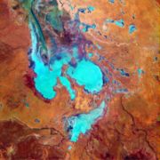
Location and description
The Tirari Desert features salt lakes and large north-south running sand dunes.It is located partly within the Lake Eyre National Park
Lake Eyre National Park
Lake Eyre National Park is located in South Australia , 697 km north of Adelaide. It contains both the North and South sections of Lake Eyre as well as sections of the Tirari Desert....
. It lies mainly to the east of Lake Eyre
Lake Eyre
Lake Eyre is the lowest point in Australia, at approximately below sea level, and, on the rare occasions that it fills, it is the largest lake in Australia and 18th largest in the world...
North. Cooper Creek
Cooper Creek
Cooper Creek is one of the most famous and yet least visited rivers in Australia. It is sometimes known as the Barcoo River from one of its tributaries and is one of three major Queensland river systems that flow into the Lake Eyre Basin...
runs through the centre of the desert.
The adjacent deserts of the area include Simpson Desert
Simpson Desert
The Simpson Desert is a large area of dry, red sandy plain and dunes in Northern Territory, South Australia and Queensland in central Australia. It is the fourth largest Australian desert, with an area of 176,500 km² ....
which lies to the north while the Strzelecki Desert
Strzelecki Desert
The Strzelecki Desert is located in the Far North Region of South Australia, southwest Queensland and western New South Wales. It is positioned in the northeast of the Lake Eyre Basin, and north of the Flinders Ranges. Two other deserts occupy the Lake Eyre Basin—the Tirari Desert and the...
is to the east and the Sturt Stony Desert runs aligned with the Birdsville track to the north east.
The desert experiences harsh conditions with high temperatures and very low rainfall (mean annual rainfall is below 125 millimetres (4.9 in)).
Access and stations
The main vehicular access to the desert is via the unpaved Birdsville TrackBirdsville Track
The Birdsville Track is a notable outback road in Australia. The 517 km track runs from Marree, a small town in northern South Australia, north across the Tirari Desert and Sturt Stony Desert, ending in Birdsville in south western Queensland....
which runs northwards from Marree
Marree, South Australia
Marree is a small town located in the north of South Australia. It lies North of Adelaide at the junction of the Oodnadatta Track and the Birdsville Track, above sea level. The area is the home of the Dieri people. At the 2006 census, Marree had a population of 70.The town was home to Australia's...
to Birdsville
Birdsville, Queensland
-External links:*...
. The Mungerannie Hotel is the only location between the two towns that provides services.
The Tirari Desert region has a number of large cattle station
Cattle station
Cattle station is an Australian term for a large farm , whose main activity is the rearing of cattle. In Australia, the owner of a cattle station is called a grazier...
s which are stopping points on the Channel Country
Channel Country
The Channel Country is region of outback Australia located mostly in the state of Queensland but also in portions of South Australia, Northern Territory and New South Wales. The name comes from the numerous intertwined rivulets that cross the region, which cover 150,000 km²...
aviation mail run.
Dulkaninna Station has been run by the same family for 110 years, has 2000 cattle and breeds horses and kelpie
Australian Kelpie
The Kelpie is an Australian sheep dog successful at mustering and droving with little or no command guidance. They are medium-sized dogs and come in a variety of colours...
s. Etadunna Station to the north is a 1 million acres (4,046.9 km²) cattle station
Cattle station
Cattle station is an Australian term for a large farm , whose main activity is the rearing of cattle. In Australia, the owner of a cattle station is called a grazier...
with 2500 cattle.
The station environs include a number of heritage sites include Bucaltaninna Homestead ruins, the Woolshed ruins and Canny Trig Point
Trig point
A triangulation station, also known as a triangulation pillar, trigonometrical station, trigonometrical point, trig station, trig beacon or trig point, and sometimes informally as a trig, is a fixed surveying station, used in geodetic surveying and other surveying projects in its vicinity...
(also known as Milner's Pile) and the state heritage-registered Killalpaninna Mission site.
Further north again is Mulka Station which also has a number of heritage sites including homestead ruins at Apatoongannie, Old Mulka and Ooroowillannie. The Mulka Store ruins is listed on the South Australian state register of heritage places.
Vegetation
Flowering plant
The flowering plants , also known as Angiospermae or Magnoliophyta, are the most diverse group of land plants. Angiosperms are seed-producing plants like the gymnosperms and can be distinguished from the gymnosperms by a series of synapomorphies...
s following rains.
The interdune soil type
Soil type
In terms of soil texture, soil type usually refers to the different sizes of mineral particles in a particular sample. Soil is made up in part of finely ground rock particles, grouped according to size as sand, silt and clay...
s and hence the vegetation, varies with the dune spacing. Closer spaced dunes result in sandy valleys that have similar vegetation to the dune sides while widely spaced dunes are separated by gibber or flood plains, each supporting particular vegetation communities.
The vegetation on the floodplains varies with the capacity of the land to retain floodwaters, and the frequency of inundation. In drier areas, species including Old Man Saltbush (Atriplex nummularia
Atriplex nummularia
Atriplex nummularia is a species of saltbush known by the common names old man saltbush, bluegreen saltbush, and giant saltbush. It is native to Australia, occurring in Western Australia, South Australia, the Northern Territory, Victoria, New South Wales, and Queensland...
), Cottonbush (Maireana aphylla
Maireana aphylla
Maireana aphylla, also known as Cotton Bush or Leafless Bluebush, is a leafless shrub which is endemic to Australia. It is usually rounded in form and grows to around 1.5 metres in height....
) and Queensland Bluebush (Chenopodium auricomum) form a sparse, open shrubland, whereas swamps and depressions are frequently associated with Swamp Cane-grass (Eragrostis australasica) and Lignum (Muehlenbeckia florulenta
Muehlenbeckia florulenta
Muehlenbeckia florulenta, commonly known as Tangled Lignum or often simply Lignum, is a plant native to inland Australia. It is associated with wetland habitats, especially those in arid and semiarid regions subject to cycles of intermittent flooding and drying out...
).
The intermittent watercourses and permanent waterholes associated with tributaries of Cooper Creek
Cooper Creek
Cooper Creek is one of the most famous and yet least visited rivers in Australia. It is sometimes known as the Barcoo River from one of its tributaries and is one of three major Queensland river systems that flow into the Lake Eyre Basin...
support woodland dominated by River Red Gum (Eucalyptus camaldulensis) and Coolibah (Eucalyptus coolabah
Eucalyptus coolabah
Eucalyptus coolabah is a eucalypt of riparian zones and is found throughout Australia from arid inland to coastal regions. The plant is commonly called coolibah or coolabah, the name being a loanword from the Indigenous Australian Yuwaaliyaay word, gulabaa.Propagation is dependent on periods of...
).
As at 2008, the Tirari Desert is included in biogeographic regions (IBRA)
Interim Biogeographic Regionalisation for Australia
The Interim Biogeographic Regionalisation for Australia is a biogeographic regionalisation of Australia developed by the Australian Government's Department of the Environment, Water, Heritage and the Arts...
SSD3: Dieri, part of the Simpson Strzelecki Dunefields (SSD) Region. The desert is also part of the Tirari-Sturt stony desert
Tirari-Sturt stony desert
The Tirari-Sturt stony desert is a large dry World Wildlife Fund ecoregion of southern Australia.-Location and description:The Tirari-Sturt stony desert ecoregion contains the gibber plains and red sands of the large Sturt Stony Desert, the Tirari Desert to its southwest and the Flinders and...
ecoregion
Ecoregion
An ecoregion , sometimes called a bioregion, is an ecologically and geographically defined area that is smaller than an ecozone and larger than an ecosystem. Ecoregions cover relatively large areas of land or water, and contain characteristic, geographically distinct assemblages of natural...
.
Fossils
The desert incorporates the Lake Ngapakaldi to Lake Palankarinna Fossil AreaLake Ngapakaldi to Lake Palankarinna Fossil Area
The Lake Ngapakaldi to Lake Palankarinna Fossil Area is a fossil protection reserve in the Tirari Desert, in the eastern part of the Far North region of South Australia. Some 3500 ha in area, it is about 70 km east of Lake Eyre and 100 km north-north-east of Marree, off the...
, a 3.5 square kilometres (1.4 sq mi) area on Australia's Register of the National Estate
Register of the National Estate
The Register of the National Estate is a listing of natural and cultural heritage places in Australia. The listing was initially compiled between 1976 and 2003 by the Australian Heritage Commission. The register is now maintained by the Australian Heritage Council...
with significant Tertiary period
Tertiary
The Tertiary is a deprecated term for a geologic period 65 million to 2.6 million years ago. The Tertiary covered the time span between the superseded Secondary period and the Quaternary...
vertebrate
Vertebrate
Vertebrates are animals that are members of the subphylum Vertebrata . Vertebrates are the largest group of chordates, with currently about 58,000 species described. Vertebrates include the jawless fishes, bony fishes, sharks and rays, amphibians, reptiles, mammals, and birds...
fossils.
History
The area was first explored by Europeans in 1866 and was previously settled by a small tribe of Aboriginals.Dieri people
The Tirari Desert has been part of the DieriDieri
The Dieri is an Indigenous Australian group and language from the South Australian desert—specifically Cooper and Leigh Creek, Lake Howitt, and Lake Hope, Lake Gregory and Clayton River and low country north of Mount Freeling.-Alternate names:DiariDiyeri...
people's native title
Native title
Native title is the Australian version of the common law doctrine of aboriginal title.Native title is "the recognition by Australian law that some Indigenous people have rights and interests to their land that come from their traditional laws and customs"...
claim. The Australian anthropologist Norman Tindale
Norman Tindale
Norman Barnett Tindale was an Australian anthropologist, archaeologist and entomologist. Born in Perth, his family moved to Tokyo from 1907 to 1915, where his father worked as an accountant at the Salvation Army mission in Japan. Soon after returning to Australia, Tindale got a job at the South...
reported a small tribe now extinct which he referred to as the Tirari. They were located at the eastern shore of Lake Eyre from Muloorina north to Warburton River; east to Killalapaninna. Tindale disagreed with the earlier findings of Alfred William Howitt
Alfred William Howitt
Alfred William Howitt was an Australian anthropologist and naturalist.-Background:Howitt was born in Nottingham, England, the son of authors William Howitt and Mary Botham. He came to the Victorian gold fields in 1852 with his father and brother to visit his uncle, Godfrey Howitt...
that these people were a horde of the Dieri as the language spoken was different from Dieri. Since Tindale's work was published, much of the data relating to Aboriginal language group
Language family
A language family is a group of languages related through descent from a common ancestor, called the proto-language of that family. The term 'family' comes from the tree model of language origination in historical linguistics, which makes use of a metaphor comparing languages to people in a...
distribution and definition has undergone revision since 1974. Tindale's focus was to depict Aboriginal tribal distribution at the time of European contact.
Missions
In the 1860s two Aboriginal missions were established near the Cooper Creek crossing of the Birdsville Track. The Moravians established a short-lived mission at Lake Kopperamanna in 1866. This was closed in 1869 due to drought conditions and poor relations with the local indigenous community.Bethesda Mission was established by German Lutherans at nearby Lake Killalpaninna around the same period and, after also being abandoned for a short time, was re-established and by the 1880s it resembled a small town with more than 20 dwellings including a church. At this time, it had a population of "several hundred aborigines and a dozen whites". Primarily financed by sheep grazing, the mission closed in 1917 due to the effects of drought and rabbit plagues. Currently, there is little evidence of the settlement other than a small cemetery and some remnant timber posts.
European exploration
On an 1866 expedition to determine the northern limit of Lake Eyre, Peter Egerton Warburton approached the desert from the west and followed the upstream course of what is now known as the Warburton River, but which he incorrectly believed was Cooper Creek. In 1874 another expedition, led by James William Lewis, again followed the river upstream to the QueenslandQueensland
Queensland is a state of Australia, occupying the north-eastern section of the mainland continent. It is bordered by the Northern Territory, South Australia and New South Wales to the west, south-west and south respectively. To the east, Queensland is bordered by the Coral Sea and Pacific Ocean...
border, retracing the route on the return journey and then headed south to the Kopperamanna mission. Subsequently, they followed the course of Cooper Creek
Cooper Creek
Cooper Creek is one of the most famous and yet least visited rivers in Australia. It is sometimes known as the Barcoo River from one of its tributaries and is one of three major Queensland river systems that flow into the Lake Eyre Basin...
to conduct a survey of the east shore of Lake Eyre. Lewis, in a later account of his expedition, said of the lake "I sincerely trust I may never see it again; it is useless in every respect, and the very sight of it creates thirst in man and beast."