
Tidal River, Wilsons Promontory
Encyclopedia
Tidal River is a river in Wilsons Promontory National Park
, Wilsons Promontory
, Victoria
, Australia
. It is also a permanent camping ground that takes its name from the river, which flows past the camping ground to the north, and provides it with all its fresh water.
 Tidal River is the only permanent camping ground within Wilsons Promontory National Park
. All other camping is restricted to overnight stays at bush camps while undertaking the many through-walks available in the park.
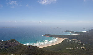
Tidal River camping ground nestles in sand dunes behind Norman Bay, on the western side of the peninsula. The only road open to visitors leads from Yanakie at the park entrance to Tidal River, a distance of 32 km. When fully occupied, Tidal River is a township of over 2000 people with a general store, a service station, fish and chippery, café and an outdoor cinema, established since the late 1940s. It is a nostalgic favourite amongst summer campers who will sometimes line up for over an hour before tickets can be bought so they can save a seat in the front row with a blanket for the 9.15pm start. Tidal River is the only place in Wilsons Promontory that has proper, flushing toilets.
Tidal River is the starting point of numerous short and not so short walks. Probably the most popular is the overnight hike to South Point
and the Wilsons Promontory Lighthouse
on South East Point
. South Point (the most southerly point of the Australian mainland) is mostly unremarkable of itself, and is easily overshadowed by South East Point, the site of the Wilsons Promontory Lighthouse
. The hike to the Wilsons Promontory Lighthouse, with detour to South Point , is over 25 km. The return walk, via a different path (and no detour) is a little over 20 km.
One of the most popular walks for families staying at Tidal river is the 3 km Squeaky Beach walk, an enjoyable walk which passes over the ridge separating Norman and Squeaky Beach. As its name suggests, Squeaky Beach, squeaks when walked on. This is due to the ultra-fine quartz
sand particles, all of which are the same size and shape. The beach is very popular among children as it has many large rocks that can be climbed. The water, however, is very rough and often full of rips. The beach also has a small stream, similar in colour to Tidal River.
For most of the year campers can set up their tents without having to book a place at the campsite. However, in the peak seasons, such as Christmas and Easter a reservation is required due to the popularity of the site.
Tidal River is a very interesting colour, ranging from a deep-yellow in shallower areas to a dark-purple and almost black in the deeper spots. This discolouration is due to the large number of tea tree
s present in the area. The trees dye the river, making it appear like black tea (hence the name 'tea tree'). Even though the water is very clean and clear it is impossible to see to the bottom in the deep areas. Few water creatures inhabit the river.
Wilsons Promontory National Park
Wilsons Promontory National Park, commonly known as Wilsons Prom or The Prom, is a national park in the Gippsland region of Victoria , 157 km southeast of Melbourne....
, Wilsons Promontory
Wilsons Promontory
Wilsons Promontory is a peninsula that forms the southernmost part of the Australian mainland and is located at . South Point at is the southernmost tip of Wilsons Promontory and hence of mainland Australia...
, Victoria
Victoria (Australia)
Victoria is the second most populous state in Australia. Geographically the smallest mainland state, Victoria is bordered by New South Wales, South Australia, and Tasmania on Boundary Islet to the north, west and south respectively....
, Australia
Australia
Australia , officially the Commonwealth of Australia, is a country in the Southern Hemisphere comprising the mainland of the Australian continent, the island of Tasmania, and numerous smaller islands in the Indian and Pacific Oceans. It is the world's sixth-largest country by total area...
. It is also a permanent camping ground that takes its name from the river, which flows past the camping ground to the north, and provides it with all its fresh water.
The campsite
Wilsons Promontory National Park
Wilsons Promontory National Park, commonly known as Wilsons Prom or The Prom, is a national park in the Gippsland region of Victoria , 157 km southeast of Melbourne....
. All other camping is restricted to overnight stays at bush camps while undertaking the many through-walks available in the park.
Tidal River camping ground nestles in sand dunes behind Norman Bay, on the western side of the peninsula. The only road open to visitors leads from Yanakie at the park entrance to Tidal River, a distance of 32 km. When fully occupied, Tidal River is a township of over 2000 people with a general store, a service station, fish and chippery, café and an outdoor cinema, established since the late 1940s. It is a nostalgic favourite amongst summer campers who will sometimes line up for over an hour before tickets can be bought so they can save a seat in the front row with a blanket for the 9.15pm start. Tidal River is the only place in Wilsons Promontory that has proper, flushing toilets.
Tidal River is the starting point of numerous short and not so short walks. Probably the most popular is the overnight hike to South Point
South Point (Wilsons Promontory)
South Point is the southernmost point of the Australian mainland located on the northern side of Bass Strait. It is also the southernmost point of the mainland of the Wilsons Promontory-Peninsula. South Point is located at . South Point is also part of the Wilsons Promontory National Park in...
and the Wilsons Promontory Lighthouse
Wilsons Promontory Lighthouse
Wilsons Promontory Lighthouse is situated on South East Point, Wilsons Promontory, Victoria, Australia. From its pont on the peninsula, it commands almost 360° views of Bass Strait. The Wilson's Promontory lighthouse is the southernmost lighthouse on mainland Australia. The walk from the nearest...
on South East Point
South East Point, Wilsons Promontory
South East Point lies on the southerly tip of Wilsons Promontory, Victoria, Australia. South East Point is located at . It commands sensational views of Bass Strait and is a major landmark for all ships travelling between the southern Australian ports and the Pacific Ocean. South East Point is the...
. South Point (the most southerly point of the Australian mainland) is mostly unremarkable of itself, and is easily overshadowed by South East Point, the site of the Wilsons Promontory Lighthouse
Wilsons Promontory Lighthouse
Wilsons Promontory Lighthouse is situated on South East Point, Wilsons Promontory, Victoria, Australia. From its pont on the peninsula, it commands almost 360° views of Bass Strait. The Wilson's Promontory lighthouse is the southernmost lighthouse on mainland Australia. The walk from the nearest...
. The hike to the Wilsons Promontory Lighthouse, with detour to South Point , is over 25 km. The return walk, via a different path (and no detour) is a little over 20 km.
One of the most popular walks for families staying at Tidal river is the 3 km Squeaky Beach walk, an enjoyable walk which passes over the ridge separating Norman and Squeaky Beach. As its name suggests, Squeaky Beach, squeaks when walked on. This is due to the ultra-fine quartz
Quartz
Quartz is the second-most-abundant mineral in the Earth's continental crust, after feldspar. It is made up of a continuous framework of SiO4 silicon–oxygen tetrahedra, with each oxygen being shared between two tetrahedra, giving an overall formula SiO2. There are many different varieties of quartz,...
sand particles, all of which are the same size and shape. The beach is very popular among children as it has many large rocks that can be climbed. The water, however, is very rough and often full of rips. The beach also has a small stream, similar in colour to Tidal River.
For most of the year campers can set up their tents without having to book a place at the campsite. However, in the peak seasons, such as Christmas and Easter a reservation is required due to the popularity of the site.
The river
As its name suggests, Tidal River swells with the tide. When a high tide occurs at the same time as a large amount of precipitation, the river can flood the tracks and boardwalks surrounding the area. The river runs into Norman Beach, one of the 'safer' beaches of the promontory. Because of its proximity to the beach and the types of rocks in the area, the Tidal River bed is composed purely of fine sand. The sand can be walked on when the tide it is low. However, it is very squishy and squelchy, due to the fineness of the sand particles mixed with the surrounding dirt.Tidal River is a very interesting colour, ranging from a deep-yellow in shallower areas to a dark-purple and almost black in the deeper spots. This discolouration is due to the large number of tea tree
Tea tree
Tea tree or Ti-tree is a popular name that has been applied to a number of different, unrelated plants:*Camellia sinensis , from which black, green, oolong and white tea are all obtained....
s present in the area. The trees dye the river, making it appear like black tea (hence the name 'tea tree'). Even though the water is very clean and clear it is impossible to see to the bottom in the deep areas. Few water creatures inhabit the river.