

Thwaites Glacier
Encyclopedia
Thwaites Glacier is an unusually broad and fast Antarctic glacier flowing into Pine Island Bay, part of the Amundsen Sea
, east of Mount Murphy
, on the Walgreen Coast
of Marie Byrd Land
. Its surface speeds exceed 2 km/yr near its grounding line, and its fastest flowing grounded ice is centred between 50 and 100 km east of Mount Murphy. It was named by ACAN
for Fredrik T. Thwaites, a glacial geologist, geomorphologist
and professor emeritus at the University of Wisconsin–Madison
. Thwaits Glacier drains into west Antarctica’s Amundsen Sea and is being closely watched for its potential to raise global sea levels.
Along with Pine Island Glacier
, Thwaites Glacier has been described as part of the "weak underbelly" of the West Antarctic Ice Sheet
, due to its apparent vulnerability to significant retreat. This hypothesis is based on both theoretical studies of the stability of marine ice sheets and recent observations of large changes on both of these glaciers. In recent years, the flow of both of these glaciers has accelerated, their surfaces have lowered, and their grounding lines have retreated.
In 2011, using geophysical data collected from flights over Thwaites Glacier (data collected under NASA's Ice Bridge campaign), a study by scientists at Columbia University’s Lamont-Doherty Earth Observatory showed a rock feature, a ridge 700 meters tall helps anchor the glacier and actually helped slow the glacier's slide into the sea. The study also confirms the importance of seafloor topography in predicting how these glaciers will behave in the near future.
 The Thwaites Glacier Tongue, or Thwaites Ice Tongue (75°0′S 106°50′W), is about 50 km wide and has progressively shortened due to ice calving
, based on the observational record. It was initially delineated from aerial photographs collected during Operation Highjump
in January 1947.
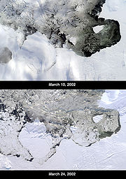
On 15 March 2002, the National Ice Center
reported that an iceberg
named B-22 broke off from the ice tongue
. This iceberg was about 85 km long by 65 km wide, with a total area of some 5,490 km². As of 2003, B-22 had broken into five pieces, with B-22A still in the vicinity of the tongue, while the other smaller pieces had drifted farther west.
. The feature was about 112-km long and 32-km wide, and in January 1966 its southern extent was only 5 km north of Thwaites Glacier Tongue. It consisted of icebergs which had broken off from the Thwaites Ice Tongue and ran aground, and should not be confused with the latter, which is still attached to the grounded ice. It was delineated by the USGS
from aerial photographs collected during Operation Highjump
and Operation Deepfreeze. It was first noted in the 1930s, but finally detached from the ice tongue off and broke up in the late 1980s.
Amundsen Sea
The Amundsen Sea is an arm of the Southern Ocean off Marie Byrd Land in western Antarctica. It is bounded by Cape Flying Fish, the northwestern tip of Thurston Island to the east and Cape Dart on Siple Island to the west. East of Cape Flying Fish starts the Bellingshausen Sea. West of Cape Dart is...
, east of Mount Murphy
Mount Murphy
Mount Murphy is a massive, snow-covered and highly eroded shield volcano with steep, rocky slopes. It is directly south of Bear Peninsula, Marie Byrd Land. The mountain is bounded by the Smith, Pope and Haynes Glaciers....
, on the Walgreen Coast
Walgreen Coast
The Walgreen Coast is a portion of the coast of Antarctica between Cape Herlacher and Cape Waite, or between Bakutis Coast in the west, and Eights Coast. It is the easternmost part of Marie Byrd Land. It stretches from 114°12'W to 103°24'W. Eights Coast to the east is already part of Ellsworth Land...
of Marie Byrd Land
Marie Byrd Land
Marie Byrd Land is the portion of West Antarctica lying east of the Ross Ice Shelf and the Ross Sea and south of the Pacific Ocean, extending eastward approximately to a line between the head of the Ross Ice Shelf and Eights Coast. It stretches between 158°W and 103°24'W...
. Its surface speeds exceed 2 km/yr near its grounding line, and its fastest flowing grounded ice is centred between 50 and 100 km east of Mount Murphy. It was named by ACAN
Advisory Committee on Antarctic Names
The Advisory Committee on Antarctic Names is an advisory committee of the United States Board on Geographic Names responsible for recommending names for features in Antarctica...
for Fredrik T. Thwaites, a glacial geologist, geomorphologist
Geomorphology
Geomorphology is the scientific study of landforms and the processes that shape them...
and professor emeritus at the University of Wisconsin–Madison
University of Wisconsin–Madison
The University of Wisconsin–Madison is a public research university located in Madison, Wisconsin, United States. Founded in 1848, UW–Madison is the flagship campus of the University of Wisconsin System. It became a land-grant institution in 1866...
. Thwaits Glacier drains into west Antarctica’s Amundsen Sea and is being closely watched for its potential to raise global sea levels.
Along with Pine Island Glacier
Pine Island Glacier
- Ice sheet drainage :The Antarctic ice sheet is the largest mass of ice on earth, containing a volume of water equivalent to of global sea level. The ice sheet forms from snow which falls onto the continent and compacts under its own weight. The ice then moves under its own weight toward the...
, Thwaites Glacier has been described as part of the "weak underbelly" of the West Antarctic Ice Sheet
West Antarctic Ice Sheet
The West Antarctic Ice Sheet is the segment of the continental ice sheet that covers West Antarctica, the portion of Antarctica on the side of the Transantarctic Mountains which lies in the Western Hemisphere. The WAIS is classified as a marine-based ice sheet, meaning that its bed lies well...
, due to its apparent vulnerability to significant retreat. This hypothesis is based on both theoretical studies of the stability of marine ice sheets and recent observations of large changes on both of these glaciers. In recent years, the flow of both of these glaciers has accelerated, their surfaces have lowered, and their grounding lines have retreated.
In 2011, using geophysical data collected from flights over Thwaites Glacier (data collected under NASA's Ice Bridge campaign), a study by scientists at Columbia University’s Lamont-Doherty Earth Observatory showed a rock feature, a ridge 700 meters tall helps anchor the glacier and actually helped slow the glacier's slide into the sea. The study also confirms the importance of seafloor topography in predicting how these glaciers will behave in the near future.
Thwaites Glacier Tongue
Calving
Calving may refer to:*Calving, the process of giving birth to a calf*Ice calving, the process by which an iceberg breaks off from an ice shelf or glacier...
, based on the observational record. It was initially delineated from aerial photographs collected during Operation Highjump
Operation Highjump
Operation Highjump , officially titled The United States Navy Antarctic Developments Program, 1946-1947, was a United States Navy operation organized by RADM Richard E. Byrd Jr. USN, , Officer in Charge, Task Force 68, and led by RADM Richard H. Cruzen, USN, Commanding Officer, Task Force 68....
in January 1947.
On 15 March 2002, the National Ice Center
National Ice Center
The National Ice Center is a tri-agency operational center whose mission is to provide world-wide navigational ice analyses for the armed forces of the United States, allied nations, and U.S...
reported that an iceberg
Iceberg
An iceberg is a large piece of ice from freshwater that has broken off from a snow-formed glacier or ice shelf and is floating in open water. It may subsequently become frozen into pack ice...
named B-22 broke off from the ice tongue
Ice tongue
An ice tongue is a long and narrow sheet of ice projecting out from the coastline. An ice tongue forms when a valley glacier moves very rapidly out into the ocean or a lake....
. This iceberg was about 85 km long by 65 km wide, with a total area of some 5,490 km². As of 2003, B-22 had broken into five pieces, with B-22A still in the vicinity of the tongue, while the other smaller pieces had drifted farther west.
Thwaites Iceberg Tongue
The Thwaites Iceberg Tongue (74°0′S 108°30′W) was a large iceberg tongue which was aground in the Amundsen Sea, about 32 km northeast of Bear PeninsulaBear Peninsula
Bear Peninsula is a peninsula about 80 km long and 40 km wide which is ice covered except for several isolated rock bluffs and outcrops along its margins, lying 48 km 30 mi) east of Martin Peninsula on Walgreen Coast, Marie Byrd Land.First delineated from aerial photographs...
. The feature was about 112-km long and 32-km wide, and in January 1966 its southern extent was only 5 km north of Thwaites Glacier Tongue. It consisted of icebergs which had broken off from the Thwaites Ice Tongue and ran aground, and should not be confused with the latter, which is still attached to the grounded ice. It was delineated by the USGS
United States Geological Survey
The United States Geological Survey is a scientific agency of the United States government. The scientists of the USGS study the landscape of the United States, its natural resources, and the natural hazards that threaten it. The organization has four major science disciplines, concerning biology,...
from aerial photographs collected during Operation Highjump
Operation Highjump
Operation Highjump , officially titled The United States Navy Antarctic Developments Program, 1946-1947, was a United States Navy operation organized by RADM Richard E. Byrd Jr. USN, , Officer in Charge, Task Force 68, and led by RADM Richard H. Cruzen, USN, Commanding Officer, Task Force 68....
and Operation Deepfreeze. It was first noted in the 1930s, but finally detached from the ice tongue off and broke up in the late 1980s.