

Three Rivers Park District
Encyclopedia
Three Rivers Park District is a "special park district" serving the suburban areas of the Twin Cities metro including suburban Hennepin, Carver, Dakota, Scott and Ramsey counties. The mission of Three Rivers is, "[T]o promote environmental stewardship through recreation and education in a natural resources-based park system." Three Rivers currently operates twenty parks and ten regional trails, with at least two more planned regional trails. Nearly seven million people visit Three Rivers facilities each year.
had been proposed as early as 1901, but it was not until 1955 that the Minnesota Legislature passed the enabling legislation which cleared the way to establish the park system in 1957. It was known then as the Hennepin County Park Reserve District. For its first decade, the Park District purchased nearly 21000 acres (85 km²) of property, mostly farmland in the fast-growing suburban areas of Hennepin County. In 1967, the Park District began efforts to restore wetland, prairie, woodland, and wildlife habitat to their natural state, before 19th century settlement. The park district now has a policy stating that at least 80% of the land in a park reserve must be maintained or restored to its natural state, and only 20% of the land will be developed for active recreation. Not all of the parks in the system are park reserves; some of the smaller or more-developed parks are "regional parks".
Beginning in the 1970s, the focus shifted from acquisition of new lands to development. The building of recreational facilities including park buildings, beaches, boat launches, paved trails for hiking and biking, and cross-country ski trails began in earnest.
In 2005 the park system was renamed Three Rivers Park District to better reflect the areas it serves. Each of the Park District's facilities is located with watersheds that flow into three rivers - the Mississippi, Minnesota and Crow. These rivers have historically been and continue to be, significant in the lives of the region's residents.

. Its highlights include the Baker Near-Wilderness Settlement retreat, available for use by families and groups, and Baker National Golf Course. It has 8 miles (12.9 km) of paved biking/hiking trails. There is a mountain biking
trail available by special-use permit in the winter.
and has an area of 170 acre (0.6879662 km²). It features a swimming beach on Bryant Lake, a disc golf
course, and a mix of paved and unpaved trails.
, in Carver County
, it features the Lowry Nature Center with interpretive programs, nine miles (14 km) of paved biking/hiking trails, 22 miles (35.4 km) of unpaved hiking trails, and nine miles (14 km) of horse trails. It is also connected to the Southwest LRT Trail
's northern branch.
. Its 1186 acres (4.8 km²) contain a nine-hole golf course, an off-leash pet exercise area, and four miles (6 km) of paved biking/hiking trails.
and Coon Rapids, Minnesota
. The dam, for which the park was named, was built by Northern States Power Company
in 1913 for electrical power generation. Power generation was discontinued in 1966, so the dam is now used for recreation. Anoka County
operates a park on its side of the dam.
There is a pedestrian and bicycle walkway across the Dam. It also connects to the Elm Creek Regional Trail, which stretches six miles (10 km) across Brooklyn Park and Maple Grove to meet up with Elm Creek Park Reserve.
This park and the Coon Rapids Dam East, a walk across the dam, are sites for the National Parks Passport Program
for the Mississippi National River and Recreation Area
.
, Crow-Hassan Park Reserve has an area of 2597 acres (10.5 km²), including 600 acres (2.4 km²) of tall-grass prairie
. The park features 18 miles (29 km) of unpaved hiking trails, 11 miles (17.7 km) of horse trails, and an off-leash dog area.
and Maple Grove, Minnesota
and features a nine-hole golf course with a lighted driving range.
, Champlin
and Dayton
. It features 19 miles (30.6 km) of paved biking/hiking trails, 21 miles (33.8 km) of horse trails, and a five mile (8 km) mountain bike trail. It also has a championship level disc golf course and a popular chlorinated swimming pond and a creative play area. A regional trail system connects Elm Creek Park Reserve to Fish Lake Regional Park and Coon Rapids Dam Regional Park. In the winter, portions of the 11 miles (17.7 km) cross-country ski trail system are served by snowmaking. They also offer a snowtubing hill and a small downhill ski/snowboard area featuring a small terrain park. The Eastman Nature Center provides interpretive programs. This park also has more bike trails than all other parks in the park district, at 29.1 miles (46.8 km).
and offers boat access to Fish Lake, as well as a swimming beach and four-season pavilion.
, Clifton E. French Regional Park (referred to locally as French Park) contains a popular creative play area and a large Nature Exploration Area, where patrons do not have to stay on paths and may do activities that are forbidden elsewhere in the park, such as digging or building forts. It also includes boat access to Medicine Lake. In the winter, it has six miles (10 km) of cross-country ski trails. The park is connected to Medicine Lake Regional Trail.
, is a working farm featuring interpretive programs where visitors can learn about agriculture and land stewardship. The farm is also home to the Gale Woods Folk School that offers classes in cooking and the fiber arts. The park also includes a barn-style pavilion overlooking the lake.
and Eden Prairie
. It features a popular nine-hole golf course, along with a driving range and practice areas. It is built on the site of the former Glen Lake Sanatorium
.
, is a living history museum featuring a number of restored buildings from the 19th century. Interpreters in period clothing show visitors what life was like in the pioneering days of Minnesota. The site is open to the public from Memorial Day through October, and available for school groups from April through December. It also offers a popular "Folkways of the Holidays" program in December.
 Hyland Lake Park Reserve, located in Bloomington
, features the Hyland Ski and Snowboard Area, a downhill ski area with two terrain parks. The park is home to a massive creative play area that is a favorite of local residents.(pictured right). The ski area is popular for lessons and for its proximity to the metro area. On Hyland Lake at the playground there is a chalet with a concessions stand and tables and chairs. During the winter the chalet has cross country ski rentals. The rest of the park reserve's 1000 acres (4 km²) contain nine miles (14 km) of paved biking/hiking trails and other unpaved hiking trails. In addition, the park features an 18-hole championship-level disc golf course playing along the ski slopes. The visitor's center offers boat and kayak rentals for use on Hyland Lake. In the winter, seven miles (11 km) of cross-country ski trails are offered, and some trails are lit for evening use. Hyland Lake Park Reserve also hosts Richardson Nature Center. The center offers live animal displays, interpretive nature programs and winter snowshoe
rentals.
, Lake Minnetonka Regional Park is a relatively new park in the Three Rivers system. It offers a chlorinated sand-bottom swimming pond and a creative play area. It also provides boat access to Lake Minnetonka
.
and Independence
, is a large park reserve with 2577 acres (10.4 km²). It offers seven miles (11 km) of biking/hiking trails, 13 miles (20.9 km) of unpaved hiking trails, and a four mile (6 km) mountain bike trail. It also has a non-motorized lake for canoeing, rowing, and fishing. In the winter, there are 10 miles (16.1 km) of cross-country ski trails.
, and Credit River Township
, features a hilly cross-country ski trail system and a six mile (10 km) hilly mountain bike trail. The mountain bike trail is probably one of the most challenging trails in the Twin Cities due to its long climbs and rapid descents. The park reserve, at 2786 acres (11.3 km²), also includes 14 miles (22.5 km) of horse trails, as well as bird watching. It is the only known nesting site of the hooded warbler
in Minnesota. Also includes a hiking trail that is 3.1 miles (5 km) at the longest and 2.3 miles (3.7 km) at the shortest
, is considered one of Minnesota's finest formal public gardens. It was donated to the park reserve by the estate of Frederick Noerenberg, founder of the Grain Belt
brewery. The gardens are open May through October for tours, programs, informal viewing, and weddings.

on the border of Minneapolis
and Brooklyn Center
. It has a scenic view of the river and surrounding woods, along with a paved biking/hiking trail that connects to the Minneapolis trail system and to the Anoka County Park trails that go north to the Coon Rapids Dam.
Silver Lake Camp. Silverwood serves as a regional center devoted to connecting the community with the natural world and artistic creation. Through a gallery space, an amphitheater, art circles, and classrooms, artists engage and inspire the community with exhibitions, creations, teaching and performance. The park also features a coffee shop specializing in local, natural, organic, and sustainable foods. Picnicking, hiking trails and fishing are also available.
.
in Golden Valley to Plymouth, where it becomes the Luce Line State Trail. In Plymouth Luce Line Regional Trail connects with Medicine Lake Regional Trail.
line. In Hopkins the trail connects to Cedar Lake LRT Regional Trail and North Cedar Lake Regional Trail. It is part of the Southwest LRT Trail
.
, Cedar Lake LRT Trail, idtown_Greenway|Midtown Greenway], and the Kenilworth Trail.
History
A park system in the areas of Hennepin County outside of MinneapolisMinneapolis, Minnesota
Minneapolis , nicknamed "City of Lakes" and the "Mill City," is the county seat of Hennepin County, the largest city in the U.S. state of Minnesota, and the 48th largest in the United States...
had been proposed as early as 1901, but it was not until 1955 that the Minnesota Legislature passed the enabling legislation which cleared the way to establish the park system in 1957. It was known then as the Hennepin County Park Reserve District. For its first decade, the Park District purchased nearly 21000 acres (85 km²) of property, mostly farmland in the fast-growing suburban areas of Hennepin County. In 1967, the Park District began efforts to restore wetland, prairie, woodland, and wildlife habitat to their natural state, before 19th century settlement. The park district now has a policy stating that at least 80% of the land in a park reserve must be maintained or restored to its natural state, and only 20% of the land will be developed for active recreation. Not all of the parks in the system are park reserves; some of the smaller or more-developed parks are "regional parks".
Beginning in the 1970s, the focus shifted from acquisition of new lands to development. The building of recreational facilities including park buildings, beaches, boat launches, paved trails for hiking and biking, and cross-country ski trails began in earnest.
In 2005 the park system was renamed Three Rivers Park District to better reflect the areas it serves. Each of the Park District's facilities is located with watersheds that flow into three rivers - the Mississippi, Minnesota and Crow. These rivers have historically been and continue to be, significant in the lives of the region's residents.
Parks
Most Three Rivers Park District parks are open from 5 a.m. through 10 p.m.Baker Park Reserve
Baker Park Reserve, with an area of 3313 acres (13.4 km²), is located in Medina, MinnesotaMedina, Minnesota
Medina is a city in Hennepin County, Minnesota, United States. The population was 4,892 at the 2010 census.-Geography:According to the United States Census Bureau, the city has a total area of , of which, of it is land and of it is water...
. Its highlights include the Baker Near-Wilderness Settlement retreat, available for use by families and groups, and Baker National Golf Course. It has 8 miles (12.9 km) of paved biking/hiking trails. There is a mountain biking
Mountain biking
Mountain biking is a sport which consists of riding bicycles off-road, often over rough terrain, using specially adapted mountain bikes. Mountain bikes share similarities with other bikes, but incorporate features designed to enhance durability and performance in rough terrain.Mountain biking can...
trail available by special-use permit in the winter.
Bryant Lake Regional Park
Bryant Lake Regional Park is located in Eden Prairie, MinnesotaEden Prairie, Minnesota
As of the census of 2000, there were 54,901 people, 20,457 households, and 14,579 families residing in the city. The population density was . There were 21,026 housing units at an average density of 649.2 per square mile...
and has an area of 170 acre (0.6879662 km²). It features a swimming beach on Bryant Lake, a disc golf
Disc golf
Disc golf is a disc game in which individual players throw a flying disc into a basket or at a target. According to the Professional Disc Golf Association, "The object of the game is to traverse a course from beginning to end in the fewest number of throws of the disc." Of the more than 3000...
course, and a mix of paved and unpaved trails.
Carver Park Reserve
With an area of 3719 acres (15.1 km²), Carver Park Reserve is the second-largest park reserve in the system. Located near Victoria, MinnesotaVictoria, Minnesota
As of the census of 2000, there were 4,025 people, 1,367 households, and 1,141 families residing in the city. The population density was 575.4 people per square mile . There were 1,410 housing units at an average density of 201.6 per square mile...
, in Carver County
Carver County, Minnesota
As of the census of 2000, there were 70,205 people, 24,356 households, and 18,778 families residing in the county. The population density was 197 people per square mile . There were 24,883 housing units at an average density of 70 per square mile...
, it features the Lowry Nature Center with interpretive programs, nine miles (14 km) of paved biking/hiking trails, 22 miles (35.4 km) of unpaved hiking trails, and nine miles (14 km) of horse trails. It is also connected to the Southwest LRT Trail
Southwest LRT Trail
The Southwest LRT Trail is a system of bicycle trails that extends through several western suburbs of Minneapolis, Minnesota. They are operated by the Three Rivers Park District....
's northern branch.
Cleary Lake Regional Park
Cleary Lake Regional Park is located near Prior Lake, in Scott CountyScott County, Minnesota
Scott County is a county located in the U.S. state of Minnesota. It was organized in 1853 and named in honor of General Winfield Scott. As of 2010, the population was 129,928. Its county seat is Shakopee...
. Its 1186 acres (4.8 km²) contain a nine-hole golf course, an off-leash pet exercise area, and four miles (6 km) of paved biking/hiking trails.
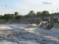
Coon Rapids Dam Regional Park
Coon Rapids Dam Regional Park is located in Brooklyn Park, MinnesotaBrooklyn Park, Minnesota
According to the 2010 census, there were 75,781 people residing in the city. The racial makeup of the city was 52% White, 24% African American, 1% Native American, 15% Asian, 42 residents identifying themselves as Pacific Islander, 4% from other races, and 4% from two or more races...
and Coon Rapids, Minnesota
Coon Rapids, Minnesota
As of the census of 2000, there were 61,627 people, 22,578 households, and 16,572 families residing in the city. The population density was 2,718.1 people per square mile . There were 22,828 housing units at an average density of 1,007.2 per square mile...
. The dam, for which the park was named, was built by Northern States Power Company
Northern States Power Company
Northern States Power Company was a publicly-traded S&P 500 electric and natural gas utility holding company based in Minneapolis, Minnesota that is now a subsidiary of Xcel Energy .-History:...
in 1913 for electrical power generation. Power generation was discontinued in 1966, so the dam is now used for recreation. Anoka County
Anoka County, Minnesota
Anoka County is the fourth-most populous county in the U.S. state of Minnesota. The county is bordered by the counties of Isanti on the north, Chisago and Washington on the east, Hennepin and Ramsey on the south, Sherburne on the west, and the Mississippi River on the southwest.As of 2010, Anoka...
operates a park on its side of the dam.
There is a pedestrian and bicycle walkway across the Dam. It also connects to the Elm Creek Regional Trail, which stretches six miles (10 km) across Brooklyn Park and Maple Grove to meet up with Elm Creek Park Reserve.
This park and the Coon Rapids Dam East, a walk across the dam, are sites for the National Parks Passport Program
National Park Passport Stamps
At nearly all of the American National Park units , one or more National Park Passport Stamps can be acquired at no cost at park visitor centers and ranger stations. The stamps are similar in nature to passport stamps stamped in a traveler's national passport...
for the Mississippi National River and Recreation Area
Mississippi National River and Recreation Area
The Mississippi National River and Recreation Area protects a and corridor along the Mississippi River from the cities of Dayton and Ramsey, Minnesota to just downstream of Hastings, Minnesota. This includes the stretch of Mississippi River which flows through Minneapolis and St. Paul, Minnesota...
.
Crow-Hassan Park Reserve
Located in Hassan Township, MinnesotaHassan Township, Minnesota
Hassan Township is a urban township in Hennepin County, Minnesota, United States. Located in the northwestern corner of the county, it is the only township in the county...
, Crow-Hassan Park Reserve has an area of 2597 acres (10.5 km²), including 600 acres (2.4 km²) of tall-grass prairie
Prairie
Prairies are considered part of the temperate grasslands, savannas, and shrublands biome by ecologists, based on similar temperate climates, moderate rainfall, and grasses, herbs, and shrubs, rather than trees, as the dominant vegetation type...
. The park features 18 miles (29 km) of unpaved hiking trails, 11 miles (17.7 km) of horse trails, and an off-leash dog area.
Eagle Lake Regional Park
Eagle Lake Regional Park is located in Plymouth, MinnesotaPlymouth, Minnesota
As of the census of 2000, there were 65,894 people, 24,820 households, and 17,647 families residing in the city. The population density was 2,002.0 persons per square mile . There were 25,258 housing units at an average density of 767.4 per square mile...
and Maple Grove, Minnesota
Maple Grove, Minnesota
As of the census of 2000, there were 50,365 people , 17,532 households, and 13,955 families residing in the city. The population density was 1,532.3 people per square mile . There were 17,745 housing units at an average density of 539.9 per square mile...
and features a nine-hole golf course with a lighted driving range.
Elm Creek Park Reserve
Elm Creek Park Reserve, at 5315 acres (21.5 km²), is the largest park reserve in the system and occupies portions of Maple GroveMaple Grove, Minnesota
As of the census of 2000, there were 50,365 people , 17,532 households, and 13,955 families residing in the city. The population density was 1,532.3 people per square mile . There were 17,745 housing units at an average density of 539.9 per square mile...
, Champlin
Champlin, Minnesota
Champlin is a city in Hennepin County, Minnesota, United States. The population was 23,089 at the 2010 census.U.S. Route 169 serves as a main arterial route in the city.- Geography :...
and Dayton
Dayton, Minnesota
Dayton is a city in Hennepin and Wright counties in the U.S. state of Minnesota. The population was 4,671 at the 2010 census. Dayton is mainly in Hennepin County, but a part of the city extends into Wright County as well. It is the northernmost city in Hennepin County.The city of Dayton, platted...
. It features 19 miles (30.6 km) of paved biking/hiking trails, 21 miles (33.8 km) of horse trails, and a five mile (8 km) mountain bike trail. It also has a championship level disc golf course and a popular chlorinated swimming pond and a creative play area. A regional trail system connects Elm Creek Park Reserve to Fish Lake Regional Park and Coon Rapids Dam Regional Park. In the winter, portions of the 11 miles (17.7 km) cross-country ski trail system are served by snowmaking. They also offer a snowtubing hill and a small downhill ski/snowboard area featuring a small terrain park. The Eastman Nature Center provides interpretive programs. This park also has more bike trails than all other parks in the park district, at 29.1 miles (46.8 km).
Fish Lake Regional Park
Fish Lake Regional Park is located in Maple GroveMaple Grove, Minnesota
As of the census of 2000, there were 50,365 people , 17,532 households, and 13,955 families residing in the city. The population density was 1,532.3 people per square mile . There were 17,745 housing units at an average density of 539.9 per square mile...
and offers boat access to Fish Lake, as well as a swimming beach and four-season pavilion.
Clifton E. French Regional Park
Located on Medicine Lake in PlymouthPlymouth, Minnesota
As of the census of 2000, there were 65,894 people, 24,820 households, and 17,647 families residing in the city. The population density was 2,002.0 persons per square mile . There were 25,258 housing units at an average density of 767.4 per square mile...
, Clifton E. French Regional Park (referred to locally as French Park) contains a popular creative play area and a large Nature Exploration Area, where patrons do not have to stay on paths and may do activities that are forbidden elsewhere in the park, such as digging or building forts. It also includes boat access to Medicine Lake. In the winter, it has six miles (10 km) of cross-country ski trails. The park is connected to Medicine Lake Regional Trail.
Gale Woods
Gale Woods, located on the shores of Whaletale Lake in MinnetristaMinnetrista, Minnesota
Minnetrista is a settlement mainly in Hennepin County, Minnesota. A very small part of Minnetrista Extends into Carver County. The name Minnetrista is said to owe its origin to the Dakota language, in which minne means "water" and trista means "crooked." The city is generally rural and still has...
, is a working farm featuring interpretive programs where visitors can learn about agriculture and land stewardship. The farm is also home to the Gale Woods Folk School that offers classes in cooking and the fiber arts. The park also includes a barn-style pavilion overlooking the lake.
Glen Lake Golf and Practice Center
Glen Lake Golf and Practice Center is located on the boundary of MinnetonkaMinnetonka, Minnesota
As of the census of 2000, there were 51,301 people, 21,393 households, and 14,097 families residing in the city. The population density was 1,893.0 persons per square mile . There were 22,228 housing units at an average density of 818.9 per square mile...
and Eden Prairie
Eden Prairie, Minnesota
As of the census of 2000, there were 54,901 people, 20,457 households, and 14,579 families residing in the city. The population density was . There were 21,026 housing units at an average density of 649.2 per square mile...
. It features a popular nine-hole golf course, along with a driving range and practice areas. It is built on the site of the former Glen Lake Sanatorium
Glen Lake Sanatorium
Glen Lake Sanatorium, a tuberculosis treatment center serving Hennepin County in Minnesota, opened on January 4, 1916, with a capacity of 50 patients. In 1909, the Minnesota State Legislature had passed a bill authorizing the appointment of county sanatorium boards and appropriating money for the...
.
The Landing
The Landing – Minnesota River Heritage Park, formerly Historic Murphy's Landing, in ShakopeeShakopee, Minnesota
Shakopee is a city southwest of downtown Minneapolis in the U.S. state of Minnesota and is the county seat of Scott County. Located on the south bank bend of the Minnesota River, Shakopee and nearby suburbs comprise the southwest portion of Minneapolis-Saint Paul, the thirteenth largest...
, is a living history museum featuring a number of restored buildings from the 19th century. Interpreters in period clothing show visitors what life was like in the pioneering days of Minnesota. The site is open to the public from Memorial Day through October, and available for school groups from April through December. It also offers a popular "Folkways of the Holidays" program in December.
Hyland Lake Park Reserve
Bloomington, Minnesota
Bloomington is the fifth largest city in the U.S. state of Minnesota in Hennepin County. Located on the north bank of the Minnesota River above its confluence with the Mississippi River, Bloomington lies at the heart of the southern...
, features the Hyland Ski and Snowboard Area, a downhill ski area with two terrain parks. The park is home to a massive creative play area that is a favorite of local residents.(pictured right). The ski area is popular for lessons and for its proximity to the metro area. On Hyland Lake at the playground there is a chalet with a concessions stand and tables and chairs. During the winter the chalet has cross country ski rentals. The rest of the park reserve's 1000 acres (4 km²) contain nine miles (14 km) of paved biking/hiking trails and other unpaved hiking trails. In addition, the park features an 18-hole championship-level disc golf course playing along the ski slopes. The visitor's center offers boat and kayak rentals for use on Hyland Lake. In the winter, seven miles (11 km) of cross-country ski trails are offered, and some trails are lit for evening use. Hyland Lake Park Reserve also hosts Richardson Nature Center. The center offers live animal displays, interpretive nature programs and winter snowshoe
Snowshoe
A snowshoe is footwear for walking over the snow. Snowshoes work by distributing the weight of the person over a larger area so that the person's foot does not sink completely into the snow, a quality called "flotation"....
rentals.
Lake Minnetonka Regional Park
Located in MinnetristaMinnetrista, Minnesota
Minnetrista is a settlement mainly in Hennepin County, Minnesota. A very small part of Minnetrista Extends into Carver County. The name Minnetrista is said to owe its origin to the Dakota language, in which minne means "water" and trista means "crooked." The city is generally rural and still has...
, Lake Minnetonka Regional Park is a relatively new park in the Three Rivers system. It offers a chlorinated sand-bottom swimming pond and a creative play area. It also provides boat access to Lake Minnetonka
Lake Minnetonka
Lake Minnetonka is a lake in the U.S. state of Minnesota. Throughout its recorded history, the lake has been a resort destination. It is located west-southwest of Minneapolis-St. Paul. The lake is an irregular shape with numerous bays and islands which make up about of shoreline...
.
Lake Rebecca Park Reserve
Lake Rebecca Park Reserve, in GreenfieldGreenfield, Minnesota
Greenfield is a city in Hennepin County, Minnesota, United States, along the Crow River. The population was 2,777 at the 2010 census.-Geography:...
and Independence
Independence, Minnesota
Independence is a city in Hennepin County, Minnesota, United States. The population was 3,504 at the 2010 census. U.S. Route 12 serves as a main arterial route in the community.-Geography:...
, is a large park reserve with 2577 acres (10.4 km²). It offers seven miles (11 km) of biking/hiking trails, 13 miles (20.9 km) of unpaved hiking trails, and a four mile (6 km) mountain bike trail. It also has a non-motorized lake for canoeing, rowing, and fishing. In the winter, there are 10 miles (16.1 km) of cross-country ski trails.
Murphy-Hanrehan Park Reserve
Murphy-Hanrehan Park Reserve, in Burnsville, Lakeville, SavageSavage, Minnesota
Savage is a suburban city south-southwest of downtown Minneapolis in Scott County in the U.S. state of Minnesota. The city is situated on the south bank of the Minnesota River in a region commonly referred to as South of the River, comprising the southern portion of Minneapolis-St. Paul, the...
, and Credit River Township
Credit River Township, Minnesota
Credit River Township is a township in Scott County, Minnesota, United States. The population was 3,895 at the 2000 census. The Credit River flows northwardly through the township.-Geography:...
, features a hilly cross-country ski trail system and a six mile (10 km) hilly mountain bike trail. The mountain bike trail is probably one of the most challenging trails in the Twin Cities due to its long climbs and rapid descents. The park reserve, at 2786 acres (11.3 km²), also includes 14 miles (22.5 km) of horse trails, as well as bird watching. It is the only known nesting site of the hooded warbler
Hooded Warbler
The Hooded Warbler, Wilsonia citrina, is a New World warbler. It breeds in eastern North America and across the eastern USA and into southernmost Canada, . It is migratory, wintering in Central America and the West Indies...
in Minnesota. Also includes a hiking trail that is 3.1 miles (5 km) at the longest and 2.3 miles (3.7 km) at the shortest
Noerenberg Memorial Gardens
Noerenberg Memorial Gardens, located in OronoOrono, Minnesota
As of the census of 2000, there were 7,538 people, 2,766 households, and 2,196 families residing in the city. The population density was 468.9 people per square mile . There were 2,909 housing units at an average density of 181.0 per square mile...
, is considered one of Minnesota's finest formal public gardens. It was donated to the park reserve by the estate of Frederick Noerenberg, founder of the Grain Belt
Grain Belt (beer)
Grain Belt is a brand of beer brewed in the American state of Minnesota, by the August Schell Brewing Company. The beer has been produced in Three varieties: Grain Belt Golden, the original style introduced in 1893, and Grain Belt Premium, first introduced in 1947, and the brand new Grain Belt...
brewery. The gardens are open May through October for tours, programs, informal viewing, and weddings.
North Mississippi Regional Park
North Mississippi Regional Park is located on the west bank of the Mississippi RiverMississippi River
The Mississippi River is the largest river system in North America. Flowing entirely in the United States, this river rises in western Minnesota and meanders slowly southwards for to the Mississippi River Delta at the Gulf of Mexico. With its many tributaries, the Mississippi's watershed drains...
on the border of Minneapolis
Minneapolis, Minnesota
Minneapolis , nicknamed "City of Lakes" and the "Mill City," is the county seat of Hennepin County, the largest city in the U.S. state of Minnesota, and the 48th largest in the United States...
and Brooklyn Center
Brooklyn Center, Minnesota
As of the census of 2010, there were 30,104 residents in Brooklyn Center. The racial makeup of the city was 49% White, 26% African American, 1% Native American, 14% Asian, 0.07% Pacific Islander, 5% from other races, and 4% from two or more races...
. It has a scenic view of the river and surrounding woods, along with a paved biking/hiking trail that connects to the Minneapolis trail system and to the Anoka County Park trails that go north to the Coon Rapids Dam.
Silverwood Park
Silverwood is the park district's newest acquisition. Located on the northwest shore of Silver Lake in St. Anthony, it was formerly the site of the Salvation ArmySalvation Army
The Salvation Army is a Protestant Christian church known for its thrift stores and charity work. It is an international movement that currently works in over a hundred countries....
Silver Lake Camp. Silverwood serves as a regional center devoted to connecting the community with the natural world and artistic creation. Through a gallery space, an amphitheater, art circles, and classrooms, artists engage and inspire the community with exhibitions, creations, teaching and performance. The park also features a coffee shop specializing in local, natural, organic, and sustainable foods. Picnicking, hiking trails and fishing are also available.
Cedar Lake LRT Regional Trail
Cedar Lake LRT Regional Trail runs from downtown Minneapolis to Hopkins along former railroad lines. It connects to other trails including Luce Line Regional Trail, North Cedar Lake Regional Trail, and Minnesota River Bluffs LRT Regional Trail. It is part of the Southwest LRT TrailSouthwest LRT Trail
The Southwest LRT Trail is a system of bicycle trails that extends through several western suburbs of Minneapolis, Minnesota. They are operated by the Three Rivers Park District....
Dakota Rail Regional Trail
The Dakota Rail Regional Trail follows the former Dakota Rail Corridor along the north side of Lake Minnetonka. The trail runs 13.5 miles (21.7 km) from Wayzata southwest to St. Bonifacius.Lake Independence Regional Trail
The Lake Independence Regional Trail is a paved trail which runs from Crow-Hassan Park Reservein Orono through Baker Park Reserve to the Luce Line State Trail in Corcoran.Lake Minnetonka LRT Regional Trail
Lake Minnetonka LRT Regional Trail is a limestone trail which runs from Hopkins to Victoria, where it connects to Carver Park Reserve. It is part of the Southwest LRT TrailSouthwest LRT Trail
The Southwest LRT Trail is a system of bicycle trails that extends through several western suburbs of Minneapolis, Minnesota. They are operated by the Three Rivers Park District....
.
Luce Line Regional Trail
Luce Line Regional Trail is a paved trail which runs nine miles (14 km) from Theodore Wirth ParkTheodore Wirth Park
Theodore Wirth Park is the largest park managed by the Minneapolis Park and Recreation Board. The park land is shared by Minneapolis and the neighboring suburb of Golden Valley. The park includes two golf courses , Wirth Lake, Birch Pond, and other amenities...
in Golden Valley to Plymouth, where it becomes the Luce Line State Trail. In Plymouth Luce Line Regional Trail connects with Medicine Lake Regional Trail.
Medicine Lake Regional Trail
Medicine Lake Regional Trail is a paved trail which runs from Elm Creek Park Reserve in Maple Grove to Luce Line Regional Trail on the south end of Medicine Lake. In between, the trail runs through Fish Lake Regional Park and Clifton E. French Regional Park. A short branch of the trail extends east of French Park into the surrounding neighborhood, ending at a city park.Minnesota River Bluffs LRT Regional Trail
Minnesota River Bluffs LRT Regional Trail is a limestone trail which runs from Hopkins to Chanhassen along the former Minneapolis and St. Louis RailwayMinneapolis and St. Louis Railway
The Minneapolis and St. Louis Railway was an American Class I railroad that built and operated lines radiating south and west from Minneapolis, Minnesota which existed for 90 years from 1870 to 1960....
line. In Hopkins the trail connects to Cedar Lake LRT Regional Trail and North Cedar Lake Regional Trail. It is part of the Southwest LRT Trail
Southwest LRT Trail
The Southwest LRT Trail is a system of bicycle trails that extends through several western suburbs of Minneapolis, Minnesota. They are operated by the Three Rivers Park District....
.
North Cedar Lake Regional Trail
North Cedar Lake Regional Trail is a paved trail which runs from Minneapolis to Hopkins, where it connects to Cedar Lake LRT Regional Trail and Minnesota River Bluffs LRT Regional Trail. North Cedar Lake Regional Trail forms part of the Cedar Lake Loop, along with Cedar Lake Regional TrailCedar Lake Trail
The Cedar Lake Regional Trail is America's first bicycle freeway. It is a rail trail that runs about from downtown Minneapolis, Minnesota west to Minnesota State Highway 100 in the neighboring suburb of St. Louis Park. The trail was inaugurated on February 17, 1995. At the trail's west end,...
, Cedar Lake LRT Trail, idtown_Greenway|Midtown Greenway], and the Kenilworth Trail.
Kenilworth Trail
The Kenilworth Trail is a paved bicycle trail in Minneapolis, Minnesota. It runs nearly and acts as a connector between the Cedar Lake Trail in the north and the Midtown Greenway in the south. Like the Cedar Lake Trail, most of the route is composed of a triple-divided cycleway/pedway with a...