

Thomas Jefferys
Encyclopedia
George III of the United Kingdom
George III was King of Great Britain and King of Ireland from 25 October 1760 until the union of these two countries on 1 January 1801, after which he was King of the United Kingdom of Great Britain and Ireland until his death...
", was an English
England
England is a country that is part of the United Kingdom. It shares land borders with Scotland to the north and Wales to the west; the Irish Sea is to the north west, the Celtic Sea to the south west, with the North Sea to the east and the English Channel to the south separating it from continental...
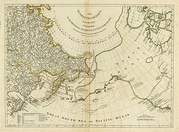
cartographer who was the leading map supplier of his day. He engraved and printed maps for government and other official bodies and produced a wide range of commercial maps and atlases, especially of North America
North America
North America is a continent wholly within the Northern Hemisphere and almost wholly within the Western Hemisphere. It is also considered a northern subcontinent of the Americas...
.
Early work
As "Geographer to the Prince of WalesFrederick, Prince of Wales
Frederick, Prince of Wales was a member of the House of Hanover and therefore of the Hanoverian and later British Royal Family, the eldest son of George II and father of George III, as well as the great-grandfather of Queen Victoria...
", he produced A Plan of all the Houses, destroyed & damaged by the Great Fire, which begun in Exchange Alley Cornhill, on Friday March 25, 1748. He produced The Small English Atlas with Thomas Kitchin
Thomas Kitchin
Thomas Kitchin was an English engraver and map-maker, who became hydrographer to the king.-Life:He was born in Southwark, and was apprenticed to Emanuel Bowen in 1732. Originally based in Clerkenwell, by late 1755 Kitchin was established on Holborn Hill. From 1773 Kitchin was royal hydrographer...
, and he engraved plans of towns in the English Midlands
English Midlands
The Midlands, or the English Midlands, is the traditional name for the area comprising central England that broadly corresponds to the early medieval Kingdom of Mercia. It borders Southern England, Northern England, East Anglia and Wales. Its largest city is Birmingham, and it was an important...
.
Maps of North America
In 1754, Jefferys published a map of VirginiaVirginia
The Commonwealth of Virginia , is a U.S. state on the Atlantic Coast of the Southern United States. Virginia is nicknamed the "Old Dominion" and sometimes the "Mother of Presidents" after the eight U.S. presidents born there...
which had been surveyed by Joshua Fry and Peter Jefferson
Peter Jefferson
Peter Jefferson was the father of American President Thomas Jefferson . A surveyor and cartographer, his Fry-Jefferson Map of 1751 accurately depicted the Allegheny Mountains for the first time and showed the route of "The Great Road from the Yadkin River thro Virginia to Philadelphia distant 455...
in 1751. The next year he published a Map of the Most Inhabited Part of New England surveyed by John Green, and in 1768 he published A General Topography of North America and the West Indies in association with Robert Sayer. In 1775, after his death, collections of his maps were published by Sayer as The American Atlas and The West-India Atlas.
Maps of English counties
Jefferys commissioned surveys and published maps of several English counties. These were large-scale maps with several sheets for each county; in the case of Bedfordshire and Huntingdonshire the scaleScale (map)
The scale of a map is defined as the ratio of a distance on the map to the corresponding distance on the ground.If the region of the map is small enough for the curvature of the Earth to be neglected, then the scale may be taken as a constant ratio over the whole map....
was two inches to one mile (1:31680).
- BedfordshireBedfordshireBedfordshire is a ceremonial county of historic origin in England that forms part of the East of England region.It borders Cambridgeshire to the north-east, Northamptonshire to the north, Buckinghamshire to the west and Hertfordshire to the south-east....
, surveyed 1765, published 1765, reprinted 1983 - HuntingdonshireHuntingdonshireHuntingdonshire is a local government district of Cambridgeshire, covering the area around Huntingdon. Traditionally it is a county in its own right...
, surveyed 1766, published 1768 - OxfordshireOxfordshireOxfordshire is a county in the South East region of England, bordering on Warwickshire and Northamptonshire , Buckinghamshire , Berkshire , Wiltshire and Gloucestershire ....
, surveyed 1766-67, published (by Andrew Dury) 1767 - County DurhamCounty DurhamCounty Durham is a ceremonial county and unitary district in north east England. The county town is Durham. The largest settlement in the ceremonial county is the town of Darlington...
, published 1768 - BuckinghamshireBuckinghamshireBuckinghamshire is a ceremonial and non-metropolitan home county in South East England. The county town is Aylesbury, the largest town in the ceremonial county is Milton Keynes and largest town in the non-metropolitan county is High Wycombe....
, surveyed 1766-68, published 1770, reprinted 2000 - WestmorelandWestmorlandWestmorland is an area of North West England and one of the 39 historic counties of England. It formed an administrative county from 1889 to 1974, after which the entirety of the county was absorbed into the new county of Cumbria.-Early history:...
, surveyed 1768, published 1770 - YorkshireYorkshireYorkshire is a historic county of northern England and the largest in the United Kingdom. Because of its great size in comparison to other English counties, functions have been increasingly undertaken over time by its subdivisions, which have also been subject to periodic reform...
, surveyed 1767-70, published 1771-72 - CumberlandCumberlandCumberland is a historic county of North West England, on the border with Scotland, from the 12th century until 1974. It formed an administrative county from 1889 to 1974 and now forms part of Cumbria....
, surveyed 1770-71, published 1774 - NorthamptonshireNorthamptonshireNorthamptonshire is a landlocked county in the English East Midlands, with a population of 629,676 as at the 2001 census. It has boundaries with the ceremonial counties of Warwickshire to the west, Leicestershire and Rutland to the north, Cambridgeshire to the east, Bedfordshire to the south-east,...
, survey (originally by Thomas Eyre) revised 1771, published 1779
After the death of Jefferys, these maps were re-issued by other map publishers such as William Faden.