

The Wedge (border)
Encyclopedia
The Wedge is a small tract of land along the borders of Delaware
, Maryland
and Pennsylvania
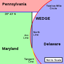
. Ownership of the land was disputed until 1921; it is now recognized as part of Delaware. The tract was created primarily due to the shortcomings of contemporary surveying techniques. It is bounded on the north by an eastern extension of the east-west portion of the Mason-Dixon Line
, on the west by the north-south portion of the Mason-Dixon line, and on the southeast by the New Castle, Delaware Twelve-Mile Circle
. The crossroads community of McClellandville, Delaware lies within the area today.
 Even though the area of the Wedge is quite small, just over one square mile , to understand its significance requires some background of the colonial history of the Province of Maryland
, the Delaware Colony
, and the Province of Pennsylvania
.
The original 1632 charter for Maryland gave the Calverts
what is now called the Delmarva Peninsula
above the latitude of Watkins Point, Maryland up to the 40th parallel
. A small Dutch settlement, Zwaanendael (1631–1632), was within their territory, as were other later New Sweden
and New Netherland
settlements along the Delaware Bay
and Delaware River
. Although the Calverts publicly stated that they wanted the settlements removed, because of the foreign policy implications for the Crown, they did not personally confront them militarily.
In 1664, the Duke of York
, brother of King Charles II
, removed foreign authority over these settlements, but in the process the Crown eventually decided that the area around New Castle
and land below it on the Delaware Bay should be separated from Maryland and administered as a new colony.
In 1681, William Penn
received his charter for Pennsylvania. This charter granted him land west of the Delaware River, and north of the 40th parallel
. However, any land within 12 miles (19.3 km) of New Castle was excluded from Pennsylvania. This demonstrates how poorly charted this area was, as New Castle is actually about 25 miles (40.2 km) south of the 40th parallel
. The Penns later acquired the New Castle lands from the Duke of York, which they called the Three Lower Counties and are now known as Delaware. Delaware, however, remained a distinct possession from Pennsylvania.
 The exact, and even approximate, boundaries of these three colonies remained in considerable dispute for the next eighty years. After settling Philadelphia
and the surrounding area, the Penns discovered that it was actually below the 40th parallel
, and tried to make claims to the land south of Philadelphia. The Calverts had failed to confirm their hold on their grant, either by surveying it or by establishing loyal settlers. The main progress through the 1750s was to survey the famous Twelve-Mile Circle around New Castle as the northern and western boundary of Delaware, and to establish the Transpeninsular Line
as its southern border. A decision was also reached between the Calverts and Penns that the boundary between their respective possessions would be:
When this was agreed upon, no one knew what the final shape would really be. Mostly due to the difficulty of surveying the Twelve-Mile Circle tangent point and the Tangent Line, astronomer Charles Mason
and surveyor Jeremiah Dixon
were hired. This complex border became known as the Mason-Dixon Line
. It turned out that there is a small wedge of land between 39° 43' N latitude, the Twelve-Mile Circle, and the North Line. The top is roughly 0.75 miles (1.2 km), and the side is roughly 3 miles (4.8 km) long. Clearly Maryland no longer had a claim to the Wedge, as it is east of the Mason-Dixon Line and as both Pennsylvania and Delaware were owned by the Penns, there was no particular incentive to determine which possession it was a part of, at least until they became separate states.
Mason and Dixon actually began surveying the Maryland-Pennsylvania border line at the Delaware River, or at least fixed the longitude of the intersection of 39° 43' N and the river. Even though this point is within the Twelve Mile Circle, the western boundary of Pennsylvania was to be five degrees of longitude west of it, and Mason and Dixon were to survey the Maryland line to Pennsylvania's western border.
By simple merits of the geometry, the Wedge more logically fit as a part of Delaware, which exercised jurisdiction of the area. In 1849, Lt. Col. J. D. Graham of the U.S. Corps of Topographical Engineers resurveyed the northeast corner of Maryland and the Twelve-Mile Circle. This survey reminded Pennsylvania of the issue and they once again claimed the Wedge. Delaware ignored the claim. In 1892, W.C. Hodgkins of the Office of the U. S. Coast and Geodetic Survey monumented an eastward extension of the Maryland-Pennsylvania border, and created the "Top of The Wedge Line". In 1921 both states settled on this boundary.
Delaware
Delaware is a U.S. state located on the Atlantic Coast in the Mid-Atlantic region of the United States. It is bordered to the south and west by Maryland, and to the north by Pennsylvania...
, Maryland
Maryland
Maryland is a U.S. state located in the Mid Atlantic region of the United States, bordering Virginia, West Virginia, and the District of Columbia to its south and west; Pennsylvania to its north; and Delaware to its east...
and Pennsylvania
Pennsylvania
The Commonwealth of Pennsylvania is a U.S. state that is located in the Northeastern and Mid-Atlantic regions of the United States. The state borders Delaware and Maryland to the south, West Virginia to the southwest, Ohio to the west, New York and Ontario, Canada, to the north, and New Jersey to...
. Ownership of the land was disputed until 1921; it is now recognized as part of Delaware. The tract was created primarily due to the shortcomings of contemporary surveying techniques. It is bounded on the north by an eastern extension of the east-west portion of the Mason-Dixon Line
Mason-Dixon line
The Mason–Dixon Line was surveyed between 1763 and 1767 by Charles Mason and Jeremiah Dixon in the resolution of a border dispute between British colonies in Colonial America. It forms a demarcation line among four U.S. states, forming part of the borders of Pennsylvania, Maryland, Delaware, and...
, on the west by the north-south portion of the Mason-Dixon line, and on the southeast by the New Castle, Delaware Twelve-Mile Circle
The Twelve-Mile Circle
The Twelve-Mile Circle is an approximately circular arc which forms most of the boundary between the Commonwealth of Pennsylvania and the State of Delaware in the United States...
. The crossroads community of McClellandville, Delaware lies within the area today.
History
Province of Maryland
The Province of Maryland was an English and later British colony in North America that existed from 1632 until 1776, when it joined the other twelve of the Thirteen Colonies in rebellion against Great Britain and became the U.S...
, the Delaware Colony
Delaware Colony
Delaware Colony in the North American Middle Colonies was a region of the Province of Pennsylvania although never legally a separate colony. From 1682 until 1776 it was part of the Penn proprietorship and was known as the lower counties...
, and the Province of Pennsylvania
Province of Pennsylvania
The Province of Pennsylvania, also known as Pennsylvania Colony, was founded in British America by William Penn on March 4, 1681 as dictated in a royal charter granted by King Charles II...
.
The original 1632 charter for Maryland gave the Calverts
Baron Baltimore
Baron Baltimore, of Baltimore Manor in County Longford, was a title in the Peerage of Ireland. It was created in 1625 for George Calvert and became extinct on the death of the sixth Baron in 1771. The title was held by several members of the Calvert family who were proprietors of the palatinates...
what is now called the Delmarva Peninsula
Delmarva Peninsula
The Delmarva Peninsula is a large peninsula on the East Coast of the United States, occupied by most of Delaware and portions of Maryland and Virginia...
above the latitude of Watkins Point, Maryland up to the 40th parallel
40th parallel north
The 40th parallel north is a circle of latitude that is 40 degrees north of the Earth's equatorial plane. It crosses Europe, the Mediterranean Sea, Asia, the Pacific Ocean, North America, and the Atlantic Ocean....
. A small Dutch settlement, Zwaanendael (1631–1632), was within their territory, as were other later New Sweden
New Sweden
New Sweden was a Swedish colony along the Delaware River on the Mid-Atlantic coast of North America from 1638 to 1655. Fort Christina, now in Wilmington, Delaware, was the first settlement. New Sweden included parts of the present-day American states of Delaware, New Jersey, and Pennsylvania....
and New Netherland
New Netherland
New Netherland, or Nieuw-Nederland in Dutch, was the 17th-century colonial province of the Republic of the Seven United Netherlands on the East Coast of North America. The claimed territories were the lands from the Delmarva Peninsula to extreme southwestern Cape Cod...
settlements along the Delaware Bay
Delaware Bay
Delaware Bay is a major estuary outlet of the Delaware River on the Northeast seaboard of the United States whose fresh water mixes for many miles with the waters of the Atlantic Ocean. It is in area. The bay is bordered by the State of New Jersey and the State of Delaware...
and Delaware River
Delaware River
The Delaware River is a major river on the Atlantic coast of the United States.A Dutch expedition led by Henry Hudson in 1609 first mapped the river. The river was christened the South River in the New Netherland colony that followed, in contrast to the North River, as the Hudson River was then...
. Although the Calverts publicly stated that they wanted the settlements removed, because of the foreign policy implications for the Crown, they did not personally confront them militarily.
In 1664, the Duke of York
James II of England
James II & VII was King of England and King of Ireland as James II and King of Scotland as James VII, from 6 February 1685. He was the last Catholic monarch to reign over the Kingdoms of England, Scotland, and Ireland...
, brother of King Charles II
Charles II of England
Charles II was monarch of the three kingdoms of England, Scotland, and Ireland.Charles II's father, King Charles I, was executed at Whitehall on 30 January 1649, at the climax of the English Civil War...
, removed foreign authority over these settlements, but in the process the Crown eventually decided that the area around New Castle
New Castle, Delaware
New Castle is a city in New Castle County, Delaware, six miles south of Wilmington, situated on the Delaware River. In 1900, 3,380 people lived here; in 1910, 3,351...
and land below it on the Delaware Bay should be separated from Maryland and administered as a new colony.
In 1681, William Penn
William Penn
William Penn was an English real estate entrepreneur, philosopher, and founder of the Province of Pennsylvania, the English North American colony and the future Commonwealth of Pennsylvania. He was an early champion of democracy and religious freedom, notable for his good relations and successful...
received his charter for Pennsylvania. This charter granted him land west of the Delaware River, and north of the 40th parallel
40th parallel north
The 40th parallel north is a circle of latitude that is 40 degrees north of the Earth's equatorial plane. It crosses Europe, the Mediterranean Sea, Asia, the Pacific Ocean, North America, and the Atlantic Ocean....
. However, any land within 12 miles (19.3 km) of New Castle was excluded from Pennsylvania. This demonstrates how poorly charted this area was, as New Castle is actually about 25 miles (40.2 km) south of the 40th parallel
40th parallel north
The 40th parallel north is a circle of latitude that is 40 degrees north of the Earth's equatorial plane. It crosses Europe, the Mediterranean Sea, Asia, the Pacific Ocean, North America, and the Atlantic Ocean....
. The Penns later acquired the New Castle lands from the Duke of York, which they called the Three Lower Counties and are now known as Delaware. Delaware, however, remained a distinct possession from Pennsylvania.
Philadelphia, Pennsylvania
Philadelphia is the largest city in the Commonwealth of Pennsylvania and the county seat of Philadelphia County, with which it is coterminous. The city is located in the Northeastern United States along the Delaware and Schuylkill rivers. It is the fifth-most-populous city in the United States,...
and the surrounding area, the Penns discovered that it was actually below the 40th parallel
40th parallel north
The 40th parallel north is a circle of latitude that is 40 degrees north of the Earth's equatorial plane. It crosses Europe, the Mediterranean Sea, Asia, the Pacific Ocean, North America, and the Atlantic Ocean....
, and tried to make claims to the land south of Philadelphia. The Calverts had failed to confirm their hold on their grant, either by surveying it or by establishing loyal settlers. The main progress through the 1750s was to survey the famous Twelve-Mile Circle around New Castle as the northern and western boundary of Delaware, and to establish the Transpeninsular Line
Transpeninsular Line
The Transpeninsular Line is a surveyed line, the eastern half of which forms the north-south border between Delaware and Maryland...
as its southern border. A decision was also reached between the Calverts and Penns that the boundary between their respective possessions would be:
- The Transpeninsular LineTranspeninsular LineThe Transpeninsular Line is a surveyed line, the eastern half of which forms the north-south border between Delaware and Maryland...
from the Atlantic OceanAtlantic OceanThe Atlantic Ocean is the second-largest of the world's oceanic divisions. With a total area of about , it covers approximately 20% of the Earth's surface and about 26% of its water surface area...
to its mid-point to the Chesapeake BayChesapeake BayThe Chesapeake Bay is the largest estuary in the United States. It lies off the Atlantic Ocean, surrounded by Maryland and Virginia. The Chesapeake Bay's drainage basin covers in the District of Columbia and parts of six states: New York, Pennsylvania, Delaware, Maryland, Virginia, and West...
. According to NOAA, the Middle Point monument is at: (NAD27) 382735.8698 N / 754138.4554 W or (NAD83(91)) 382736.29213 N / 754137.18951 W. The monument is a short distance east of U.S. Route 50 near Mardela Springs, MD. - A TangentTangentIn geometry, the tangent line to a plane curve at a given point is the straight line that "just touches" the curve at that point. More precisely, a straight line is said to be a tangent of a curve at a point on the curve if the line passes through the point on the curve and has slope where f...
Line from the mid-point of the Transpeninsular Line to the western side of the Twelve-Mile Circle. - A North Line from the tangent point to a line running 15 miles south of Philadelphia (approximately 39° 43' N latitude).
- The parallel at 39° 43' N was reached as a compromise to the 40th parallel40th parallel northThe 40th parallel north is a circle of latitude that is 40 degrees north of the Earth's equatorial plane. It crosses Europe, the Mediterranean Sea, Asia, the Pacific Ocean, North America, and the Atlantic Ocean....
. - Should any land within the Twelve-Mile Circle fall west of the North Line, it would remain part of Delaware. (This indeed was the case, and this segment is known as the Arc Line.)
When this was agreed upon, no one knew what the final shape would really be. Mostly due to the difficulty of surveying the Twelve-Mile Circle tangent point and the Tangent Line, astronomer Charles Mason
Charles Mason
Charles Mason was an English astronomer who made significant contributions to 18th-century science and American history, particularly through his involvement with the survey of the Mason-Dixon line, which came to mark the division between the northern and southern United States...
and surveyor Jeremiah Dixon
Jeremiah Dixon
Jeremiah Dixon was an English surveyor and astronomer who is perhaps best known for his work with Charles Mason, from 1763 to 1767, in determining what was later called the Mason-Dixon line....
were hired. This complex border became known as the Mason-Dixon Line
Mason-Dixon line
The Mason–Dixon Line was surveyed between 1763 and 1767 by Charles Mason and Jeremiah Dixon in the resolution of a border dispute between British colonies in Colonial America. It forms a demarcation line among four U.S. states, forming part of the borders of Pennsylvania, Maryland, Delaware, and...
. It turned out that there is a small wedge of land between 39° 43' N latitude, the Twelve-Mile Circle, and the North Line. The top is roughly 0.75 miles (1.2 km), and the side is roughly 3 miles (4.8 km) long. Clearly Maryland no longer had a claim to the Wedge, as it is east of the Mason-Dixon Line and as both Pennsylvania and Delaware were owned by the Penns, there was no particular incentive to determine which possession it was a part of, at least until they became separate states.
- Pennsylvania claimed the Wedge because it was beyond the Twelve-Mile Circle and past the Maryland side of the Mason-Dixon Line, therefore neither part of Maryland or Delaware. So by default it should be part of Pennsylvania.
- Delaware claimed the Wedge because it was never intended that Pennsylvania should go below the northern border of Maryland (which originally ran at 40° N all the way to the Delaware River). The North Line is logically an extension of the Tangent Line and therefore should separate Maryland and Delaware. Even though the Wedge is outside the Twelve-Mile Circle, because it is south of the 39° 43' N compromise line, it should not be part of Pennsylvania.
Mason and Dixon actually began surveying the Maryland-Pennsylvania border line at the Delaware River, or at least fixed the longitude of the intersection of 39° 43' N and the river. Even though this point is within the Twelve Mile Circle, the western boundary of Pennsylvania was to be five degrees of longitude west of it, and Mason and Dixon were to survey the Maryland line to Pennsylvania's western border.
By simple merits of the geometry, the Wedge more logically fit as a part of Delaware, which exercised jurisdiction of the area. In 1849, Lt. Col. J. D. Graham of the U.S. Corps of Topographical Engineers resurveyed the northeast corner of Maryland and the Twelve-Mile Circle. This survey reminded Pennsylvania of the issue and they once again claimed the Wedge. Delaware ignored the claim. In 1892, W.C. Hodgkins of the Office of the U. S. Coast and Geodetic Survey monumented an eastward extension of the Maryland-Pennsylvania border, and created the "Top of The Wedge Line". In 1921 both states settled on this boundary.