
The Deepings
Encyclopedia

Village
A village is a clustered human settlement or community, larger than a hamlet with the population ranging from a few hundred to a few thousand , Though often located in rural areas, the term urban village is also applied to certain urban neighbourhoods, such as the West Village in Manhattan, New...
s near the River Welland
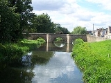
River Welland
The River Welland is a river in the east of England, some long. It rises in the Hothorpe Hills, at Sibbertoft in Northamptonshire, then flows generally northeast to Market Harborough, Stamford and Spalding, to reach The Wash near Fosdyke. For much of its length it forms the county boundary between...
, 8 miles to the north of Peterborough
Peterborough
Peterborough is a cathedral city and unitary authority area in the East of England, with an estimated population of in June 2007. For ceremonial purposes it is in the county of Cambridgeshire. Situated north of London, the city stands on the River Nene which flows into the North Sea...
and 10 miles or so east of Stamford
Stamford, Lincolnshire
Stamford is a town and civil parish within the South Kesteven district of the county of Lincolnshire, England. It is approximately to the north of London, on the east side of the A1 road to York and Edinburgh and on the River Welland...
in England
England
England is a country that is part of the United Kingdom. It shares land borders with Scotland to the north and Wales to the west; the Irish Sea is to the north west, the Celtic Sea to the south west, with the North Sea to the east and the English Channel to the south separating it from continental...
. The area is just north of the Peterborough
Peterborough
Peterborough is a cathedral city and unitary authority area in the East of England, with an estimated population of in June 2007. For ceremonial purposes it is in the county of Cambridgeshire. Situated north of London, the city stands on the River Nene which flows into the North Sea...
border in the Lincolnshire
Lincolnshire
Lincolnshire is a county in the east of England. It borders Norfolk to the south east, Cambridgeshire to the south, Rutland to the south west, Leicestershire and Nottinghamshire to the west, South Yorkshire to the north west, and the East Riding of Yorkshire to the north. It also borders...
fen
Fen
A fen is a type of wetland fed by mineral-rich surface water or groundwater. Fens are characterised by their water chemistry, which is neutral or alkaline, with relatively high dissolved mineral levels but few other plant nutrients...
s. The Deepings include: Deeping Gate
Deeping Gate
Deeping Gate is a village and civil parish, lying on the River Welland in Cambridgeshire. Traditionally, the area was part of the Soke of Peterborough, geographically considered a part of Northamptonshire; it now falls within the City of Peterborough unitary authority area...
, Deeping St James
Deeping St James
Deeping St James is a large village in Lincolnshire, England.-Geography:Deeping St James lies east of Market Deeping on the River Welland, in the middle of rich sedimentary agricultural land on the B1166 and B1162 roads. With a population of 6,923 in 2837 households, it is the largest of The...
, Deeping St Nicholas, Market Deeping
Market Deeping
Market Deeping is a market town in Lincolnshire, England, on the north bank of the River Welland and the A15 road.-Geography:It is the second largest of The Deepings and its eponymous market has been held since at least 1220. The river here forms the Lincolnshire/Cambridgeshire border with...
& West Deeping
West Deeping
West Deeping is a village in Lincolnshire, England that forms part of The Deepings, lying just off the A16 road towards Stamford to the west of Market Deeping, hence its name West Deeping. It has a population of 277. It is a Civil Parish in South Kesteven....
.
The area is very low-lying, and gave The Deepings their name (a Saxon name translatable as either 'deep places' or 'deep lands'). The villages are mentioned in the Domesday Book
Domesday Book
Domesday Book , now held at The National Archives, Kew, Richmond upon Thames in South West London, is the record of the great survey of much of England and parts of Wales completed in 1086...
. Deeping Fen
Deeping Fen
Deeping Fen is a low-lying area in Lincolnshire in the east of England, which covers around . It is bounded by the River Welland and the River Glen, and is extensively drained, but the efficient drainage of the land exercised the minds of several of the great civil engineers of the 17th and 18th...
lies to the North, and the drainage of it was an important part of 17th and 18th century land reclamation. It is now the responsibility of the Welland and Deepings Internal Drainage Board
Internal Drainage Board
An internal drainage board is a type of operating authority which is established in areas of special drainage need in England and Wales with permissive powers to undertake work to secure clean water drainage and water level management within drainage districts...
.
The town has a total population of approximately 14,900, 98% of whom are of white ethnicity
White people
White people is a term which usually refers to human beings characterized, at least in part, by the light pigmentation of their skin...
, and many of whom are retired. The town is a close-knit community. It has a large church-going
Church service
In Christianity, a church service is a term used to describe a formalized period of communal worship, often but not exclusively occurring on Sunday, or Saturday in the case of those churches practicing seventh-day Sabbatarianism. The church service is the gathering together of Christians to be...
population to the two limestone
Limestone
Limestone is a sedimentary rock composed largely of the minerals calcite and aragonite, which are different crystal forms of calcium carbonate . Many limestones are composed from skeletal fragments of marine organisms such as coral or foraminifera....
churches, one in Market Deeping
Market Deeping
Market Deeping is a market town in Lincolnshire, England, on the north bank of the River Welland and the A15 road.-Geography:It is the second largest of The Deepings and its eponymous market has been held since at least 1220. The river here forms the Lincolnshire/Cambridgeshire border with...
(Saint Guthlac
Saint Guthlac
Saint Guthlac of Crowland was a Christian saint from Lincolnshire in England. He is particularly venerated in the Fens of eastern England.-Life:...
's church
Saint Guthlac's Church, Market Deeping
Saint Guthlac's Church, Market Deeping is a parish church in the Church of England in Market Deeping, Lincolnshire.-Background:The largely 15th century church of St Guthlac is the only church in Market Deeping, Lincolnshire, England and part of the Church of England in the Anglo-Catholic Tradition...
), and the other in the village of Deeping St James
Deeping St James
Deeping St James is a large village in Lincolnshire, England.-Geography:Deeping St James lies east of Market Deeping on the River Welland, in the middle of rich sedimentary agricultural land on the B1166 and B1162 roads. With a population of 6,923 in 2837 households, it is the largest of The...
(the parish
Parish
A parish is a territorial unit historically under the pastoral care and clerical jurisdiction of one parish priest, who might be assisted in his pastoral duties by a curate or curates - also priests but not the parish priest - from a more or less central parish church with its associated organization...
church of Deeping St James). However, recently there has been a decline in the proportion of the population attending the churches with many families moving in because of the four well-performing primary schools and the excellent secondary School
Secondary school
Secondary school is a term used to describe an educational institution where the final stage of schooling, known as secondary education and usually compulsory up to a specified age, takes place...
in the area. A skatepark
Skatepark
A skatepark is a purpose-built recreational environment made for skateboarding, BMX, aggressive inline skating and scooters. A skatepark may contain half-pipes, quarter pipes, spine transfers, handrails, funboxes, vert ramps, pyramids, banked ramps, full pipes, pools, bowls, snake runs stairsets,...
and BMX
BMX
Bicycle motocross or BMX refers to the sport in which the main goal is extreme racing on bicycles in motocross style on tracks with inline start and expressive obstacles, and it is also the term that refers to the bicycle itself that is designed for dirt and motocross cycling.- History :BMX started...
track have been constructed with council
County council
A county council is the elected administrative body governing an area known as a county. This term has slightly different meanings in different countries.-United Kingdom:...
funding to accommodate the growing number of teenagers in the area. The local fish and chip shops that are beside the River Welland are popular.
As well as these two settlements, other villages that are sometimes included in The Deepings are Deeping Gate
Deeping Gate
Deeping Gate is a village and civil parish, lying on the River Welland in Cambridgeshire. Traditionally, the area was part of the Soke of Peterborough, geographically considered a part of Northamptonshire; it now falls within the City of Peterborough unitary authority area...
, a small hamlet across the River Welland in Cambridgeshire, Deeping St Nicholas to the north east on the A16 Spalding road, the longest village in Britain, and to the west West Deeping
West Deeping
West Deeping is a village in Lincolnshire, England that forms part of The Deepings, lying just off the A16 road towards Stamford to the west of Market Deeping, hence its name West Deeping. It has a population of 277. It is a Civil Parish in South Kesteven....
, which lies on King Street
King Street (Roman road)
King Street is the name of a modern road on the line of a Roman road |Durobrivae]]. The whole is I.D. Margary's Roman road number 26. -The Roman road's route:Archaeological work has revealed more of its length than is in use nowadays...
where it crosses the Welland. The villages of Frognall
Frognall
Frognall is a small village lying North East of Deeping St James in Lincolnshire, England. It is located on Spalding road , the B1525 on its route Northwards from Deeping towards the Deeping bypass and on to Spalding...
, Stowgate
Stowgate
Stowgate is a small farming settlement in Lincolnshire, England, located approximately two miles North-East of Deeping St James. Stowgate contains very few houses, most of which are farm houses, complementing the agricultural way of life in the Deepings....
, Hop Pole
Hop Pole
Hop Pole is a small Hamlet on the A16 road between Deeping St. James and Deeping St. Nicholas....
and Tongue End
Tongue End
Tongue End is a small Lincolnshire village of Victorian redbrick farmworkers' cottages and early 20th century former council houses at . It is located alongside the Counter Drain Between Baston, Bourne, and Pode Hole, spread out along the road...
are all within the various civil parish
Civil parish
In England, a civil parish is a territorial designation and, where they are found, the lowest tier of local government below districts and counties...
es.
History
Drainage of the area dates back at least as far as the Romans, and the Car DykeCar Dyke
The Car Dyke was, and to large extent still is, an eighty-five mile long ditch which runs along the western edge of the Fens in eastern England. It is generally accepted as being of Roman age and, for many centuries, to have been taken as marking the western edge of the Fens...
, but the capital involved always required a strong state, and rich men, to improve the land.
Further reading
History of the Deepings (or Three Deepings in a Row) by Florence A. Day (n.d.)The Medieval Fenland by H. C. Darby (first published by The Cambridge University Press, 1940, reprinted by David & Charles, 1974)