

The Battery, St. John's
Encyclopedia
The Battery is a small neighbourhood within the city of St. John's, Newfoundland and Labrador
.
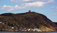
The Battery sits on the entrance to the harbour located on the slopes of Signal Hill
. Sometimes described as an outport
within the city of St. John's. The area is noted for its steep slopes, colourful houses, and its importance as a battery for the defence of St. John's Harbour in both World Wars.
The Battery is home to Chain Rock, a land outcropping to which a large chain and anti-submarine boom were attached connecting to Fort Amherst in order to prevent the entry of German U-boats into the harbour during World War II. Chain Rock is one of two rocks located on opposite sides of the Narrows
, Chain Rock on the battery side and Pancake Rock on the opposite. The space between the two rocks is 174 meters. Chain Rock and Pancake Rock were used as early as 1770. A chain was stretched between both rocks by means of a capstan at nightfall to prevent illegal entry of enemy ships. During World War I the chain was replaced with anti-submarine nets.
Another historic property in the area is Anderson House located at 42 Powers Court in the Battery as it is believed to be the oldest structure in the city of St. John's.
Although no major events have occurred since 1959, in 1995 the city of St. John's began studying the area in an attempt to minimize risk associated with rock slides and avalanches. The Canadian Avalanche Association conducted studies in the area, and based on their work, the city spent an estimated $300,000 to protect the area from further instability.

St. John's, Newfoundland and Labrador
St. John's is the capital and largest city in Newfoundland and Labrador, and is the oldest English-founded city in North America. It is located on the eastern tip of the Avalon Peninsula on the island of Newfoundland. With a population of 192,326 as of July 1, 2010, the St...
.
The Battery sits on the entrance to the harbour located on the slopes of Signal Hill
Signal Hill, Newfoundland and Labrador
Signal Hill is a hill which overlooks the city of St. John's, Newfoundland and Labrador, Canada.Due to its strategic placement overlooking the harbour, fortifications have been placed on the hill since the mid 17th century.-History:...
. Sometimes described as an outport
Outport
Outport is the name given in the United Kingdom for a subsidiary port built in deeper water than the original port. The Port of Tilbury from the Port of London is a good example. Avonmouth and Bristol and, on a smaller and now historical scale, Fordwich and Canterbury are others....
within the city of St. John's. The area is noted for its steep slopes, colourful houses, and its importance as a battery for the defence of St. John's Harbour in both World Wars.
The Battery is home to Chain Rock, a land outcropping to which a large chain and anti-submarine boom were attached connecting to Fort Amherst in order to prevent the entry of German U-boats into the harbour during World War II. Chain Rock is one of two rocks located on opposite sides of the Narrows
The Narrows, St. John's
The Narrows, the only entrance to St. John's Harbour, Newfoundland, is a narrow channel between the Southside and Signal hills. It has a least depth of 11 metres and at its narrowest point near Chain Rock is 61 metres wide....
, Chain Rock on the battery side and Pancake Rock on the opposite. The space between the two rocks is 174 meters. Chain Rock and Pancake Rock were used as early as 1770. A chain was stretched between both rocks by means of a capstan at nightfall to prevent illegal entry of enemy ships. During World War I the chain was replaced with anti-submarine nets.
Another historic property in the area is Anderson House located at 42 Powers Court in the Battery as it is believed to be the oldest structure in the city of St. John's.
Slope instability
While there have been only three major cases of recorded slope instability in The Battery, archived reports and evidence suggest that minor landslides, and a small number of avalanches, have been frequent in the area's past. A list of notable incidents of slope instability resulting in injury or death includes:| Date of Avalanche | Homes Destroyed | Human Losses |
|---|---|---|
| February 8, 1921 | One Occupied, Numerous Unoccupied | Two Severe Injuries |
| February 18, 1921 | One Home Destroyed | One Death |
| February 16, 1959 | Two Homes Destroyed | Five Deaths, Multiple Injuries |
Although no major events have occurred since 1959, in 1995 the city of St. John's began studying the area in an attempt to minimize risk associated with rock slides and avalanches. The Canadian Avalanche Association conducted studies in the area, and based on their work, the city spent an estimated $300,000 to protect the area from further instability.