
The Avenues, Salt Lake City, Utah
Encyclopedia
_map.png)
Utah
Utah is a state in the Western United States. It was the 45th state to join the Union, on January 4, 1896. Approximately 80% of Utah's 2,763,885 people live along the Wasatch Front, centering on Salt Lake City. This leaves vast expanses of the state nearly uninhabited, making the population the...
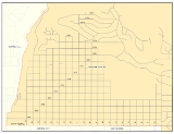
. It is named after the perfectly grid-like, closely laid out road
Road
A road is a thoroughfare, route, or way on land between two places, which typically has been paved or otherwise improved to allow travel by some conveyance, including a horse, cart, or motor vehicle. Roads consist of one, or sometimes two, roadways each with one or more lanes and also any...
s called Avenues and Streets. First surveyed in the 1850s, the Avenues became Salt Lake City's first neighborhood. Today, the Avenues neighborhood is generally considered younger, more progressive, and somewhat "artsy" when compared to other neighborhoods. Many young professionals choose to live there due to the culture and easy commute to downtown. The Avenues neighborhood is often referred to by locals as the "Avs". It is also one of the most important strongholds of the Democratic political party in Utah.
Layout and geography
The Avenues neighborhood lies on the "benches" of the Wasatch Mountains. The bottom of the Avenues is South Temple Street (1st Avenue is the next street north), and from there the neighborhood is built up onto the lower slopes of the mountains.The north-south roads in the Avenues sloping up the hillside are lettered from "A" to "U" Street and then "Virginia Street", from west to east. The fairly level east-west roads are numbered 1st to 18th Avenues counting south to north. The rigid grid system breaks down around 13th Avenue, as more recent development farther north has taken a more serpentine bend. The 'major' streets used more for through-traffic, particularly for their connections at South Temple to city arteries, are B, E, I, and Virginia; the 'major' avenues are 2nd, 3rd, 6th, 11th, and 13th.
The Avenues lie just northeast of downtown Salt Lake City, and just east—over City Creek Canyon—from Capitol Hill. The neighborhood to the east of the lower (below 11th) Avenues is known as Federal Heights, and is traditionally thought of as beginning north of South Temple Street and East of Virginia Street. It is sometimes considered a part of the Avenues, though the neighborhood may be considered as generally more affluent than the Avenues. Above Federal Heights is a more recently developed area often called Arlington Hills. Compared to the neighborhoods to the east, the Avenues are in places quite steep as they climb the foothills to the north.
The large Salt Lake City Cemetery
Salt Lake City Cemetery
thumb|The northern section of the cemetery at night, looking towards Salt Lake CityThe Salt Lake City Cemetery is in The Avenues neighborhood of Salt Lake City, Utah. Approximately 120,000 persons are buried in the cemetery. Many religious leaders and politicians, particularly many leaders of The...
occupies a significant portion of the eastern Avenues below 11th Avenue, and abuts Lindsey Gardens (park) and the 11th Avenue Park.
The "lower Avenues" (below 11th or 13th) is a neighborhood of older Victorian-era houses, and at one time was popular with younger homeowners looking for affordable "fixer-uppers", but in recent years a large renovation boom has swept the area. As fixer-uppers are diminishing, it has become less affordable to the younger crowd. It is also especially popular due to its proximity to downtown, the large and remote Memory Grove/City Creek Canyon recreation area to the West, the University of Utah to the East/Southeast, and the airport, as well as low traffic and minimal commercial development. The only significant non-residential developments are a supermarket, a few surrounding businesses, the LDS Hospital
LDS Hospital
LDS Hospital is a general urban hospital and surgical center in Salt Lake City, Utah. The hospital was originally owned by the LDS Church but is now owned and operated by Intermountain Healthcare...
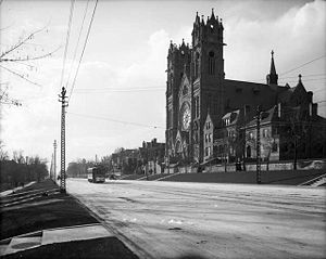
complex, and the Salt Lake Regional Medical Center
Salt Lake Regional Medical Center
The Salt Lake Regional Medical Center is a hospital in Salt Lake City, Utah.Salt Lake Regional Medical Center was formerly known as Holy Cross Hospital, which was the only Catholic Hospital in Utah for over a century. The hospital was sold by the Sisters of the Holy Cross in 1994 and renamed....
(formerly Holy Cross Hospital).
History
The Avenues is the first section of Salt Lake City to deviate from the original ten acreAcre
The acre is a unit of area in a number of different systems, including the imperial and U.S. customary systems. The most commonly used acres today are the international acre and, in the United States, the survey acre. The most common use of the acre is to measure tracts of land.The acre is related...
(40,000 m²) block grid pattern. Blocks were one half the dimension of the original grid, making them 2.5 acres (10,000 m²). Streets and sidewalks were narrower too, meaning that the Avenues' streets match poorly to the original blocks at the base of the neighborhood along South Temple Street. The first lots were surveyed in the early 1850s, but the Avenues' deviant platting violated the law. The territorial
Utah Territory
The Territory of Utah was an organized incorporated territory of the United States that existed from September 9, 1850, until January 4, 1896, when the final extent of the territory was admitted to the Union as the State of Utah....
legislature had to pass a new survey ordinance for the Avenues, which they did in 1860.
Originally, all of the streets were named. North-south streets were named for trees, and east-west streets had names like "Fruit," "Garden," "Bluff," and "Wall" (for what are now 2nd through 5th avenue respectively.) By 1885 the north-south streets gained their current alphabetical designations (A Street through V Street, although V was turned into Virginia Street.) However, the east-west streets were still known as Streets. They were not retitled into Avenues until 1907. Up until that time, the area was known as "the dry bench" because it lacked water.
Until 1884, residents in the northeastern Avenues had to haul water for everyday use. Protests prompted the city to install pipeline
Pipeline transport
Pipeline transport is the transportation of goods through a pipe. Most commonly, liquids and gases are sent, but pneumatic tubes that transport solid capsules using compressed air are also used....
s along 6th Avenue, but those living in the higher Avenues would be without water until 1908.
In spite of water problems, the Avenues proved to be an attractive residential neighborhood. In the southwest Avenues, artisans could live very close to downtown. In the east Avenues, "Butcherville" sprang up after slaughterhouses relocated to the east side in 1860.
Mule
A mule is the offspring of a male donkey and a female horse. Horses and donkeys are different species, with different numbers of chromosomes. Of the two F1 hybrids between these two species, a mule is easier to obtain than a hinny...
and horse
Horse
The horse is one of two extant subspecies of Equus ferus, or the wild horse. It is a single-hooved mammal belonging to the taxonomic family Equidae. The horse has evolved over the past 45 to 55 million years from a small multi-toed creature into the large, single-toed animal of today...
-drawn trolley
Tram
A tram is a passenger rail vehicle which runs on tracks along public urban streets and also sometimes on separate rights of way. It may also run between cities and/or towns , and/or partially grade separated even in the cities...
rides in the Avenues by 1872, and the trolleys became electric in 1889. Salt Lake Rapid Transit Company incorporated in 1890 and the companies competed fiercely until merging in 1903. The trolley system expanded to other parts of the city as the Utah Light and Traction Company, but rail lines were denser in the Avenues than any other part of the city save downtown. The tracks were removed in the 1940s after National City Lines
National City Lines
National City Lines, Inc. , was a controversial company founded in Minnesota, United States in 1920 as a modest local transport company operating two buses which was reorganized into a holding company in 1936 with equity funding from General Motors, Firestone Tire, Standard Oil of California and...
acquired (and dismantled) the trolley lines.
At the turn of the century, the neighborhood was a predominantly middle
Middle class
The middle class is any class of people in the middle of a societal hierarchy. In Weberian socio-economic terms, the middle class is the broad group of people in contemporary society who fall socio-economically between the working class and upper class....
- and upper-middle class
Social class
Social classes are economic or cultural arrangements of groups in society. Class is an essential object of analysis for sociologists, political scientists, economists, anthropologists and social historians. In the social sciences, social class is often discussed in terms of 'social stratification'...
trolley suburb, and home to many professionals. Developers, including future LDS Church President
President of the Church (Mormonism)
In the Latter Day Saint movement, the President of the Church is generally considered to be the highest office of the church. It was the office held by Joseph Smith, Jr., founder of the movement, and the office assumed by many of Smith's claimed successors, such as Brigham Young, Joseph Smith III,...
Heber J. Grant
Heber J. Grant
Heber Jeddy Grant was the seventh president of The Church of Jesus Christ of Latter-day Saints . He was ordained an apostle on October 16, 1882, on the same day as George Teasdale...
promoted Avenues home ownership.
The old Primary Children's Hospital was located in the avenues.
With the rise of other, more affluent neighborhoods like Federal Heights, the Avenues became less popular. By the 1960s, deterioration was evident as landlords often found it economically advantageous to let properties go neglected. Most homes, built between about 1880 and 1920, showed their age, and the community dealt with increasing problems with transients
Homelessness
Homelessness describes the condition of people without a regular dwelling. People who are homeless are unable or unwilling to acquire and maintain regular, safe, and adequate housing, or lack "fixed, regular, and adequate night-time residence." The legal definition of "homeless" varies from country...
. In response to these problems, residents formed the Greater Avenues Community Council (GACC) to help revitalize and restore livability to the neighborhood. Today the neighborhood has been revitalized and is considered by many to be one of Salt Lake's most desirable neighborhoods.