

Thai Nguyen Province
Encyclopedia
Thái Nguyên is a province in northeastern
Vietnam
. It is a mountainous, midland province with natural area of 3534.45 square kilometres and a population of 1,149,100 people as of 2008. Its multiethnic society is represented by eight ethnic groups.
With its rich mineral resources and salubrious climate, the province offers significant opportunities for industrial development for domestic and foreign investors. Thai Nguyen is also known as an educational centre and ranks 3rd nationwide with 21 universities and colleges. The province is also the centre of tea industry in the country with an area of 16,000 ha (second only to Lam Dong) with a production of 100,000 tonnes/year; dried tea production is 25,000 tonnes/year. The tea produced here is considered the finest in Vietnam.
 Thái Nguyên borders five provinces: Bắc Kạn
to the north, Vĩnh Phúc
and Tuyên Quang
to the west, and Lạng Sơn
and Bắc Giang
to the east. Thái Nguyên also borders the Vietnamese capital of Hanoi
to the south. Thái Nguyên is the gateway for socio-economic exchange with the Red River
delta. The exchange is carried out via road, rail and waterways in the province Main water features include the Cong River and Nui Coc Lake
.
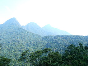
Thái Nguyên has many mountain ranges running from south to north. The structure of them is made of strongly decayed rocks with many caves and valleys. In the southwest is the Tam Dao mountain range, located on the northern fringe of the Red River Delta. The range spans some 80 kilometres, with its highest peak of 1,529 metres (note other sources state 1590 or 1592 metres) and many cliffs running from northwest to southeast.
The Tam Dao mountain region is protected by the Tam Dao National Park
, established in 1996, which is one of the largest national parks in the country. There are over 20 peaks with the park area, others of note include Thien Thi at 1375 m, Thach Ban at 1388 m and Phu Nghia at 1300 m. Sharp peaks with sloping sides and numerous, deep partitions are characteristic of the topology. The boundary of the national park is located at an altitude of 100 m around the Tam Dao range. There is a larger buffer zone (which has area of approximately 535 km2) which surrounds the national park which has an altitude below 100 m. Seventy per cent of the area of the park is covered by natural and artificial forest. The natural forest is about 220 km2 and the human altered forest is about 30 km2
There are two other mountain ranges in the province, both running in a northwest-southeast direction; the Ngan Son range running from Bắc Kạn to Vo Nhai district and the Bac Son range. Many of the mountains of Thái Nguyên Province provide shelter for a considerable part from monsoon winds.
The average temperatures in the hottest and the coldest months are 28.9 °C in June and 15.2 °C in January. The lowest recorded is 13.7 °C. Total number of sunny hours in a year is ranges between 1,300 and 1,750, which is equally distributed for months in a year. The climate of Thái Nguyên has two distinct seasons: the rainy season from May to October and dry season from October to May. The average rainfall per annum lies in the range of 2,000 to 2,500 mm; it rains most in August and least in January. Generally speaking, Thái Nguyên's climate is favourable for developing agriculture
and forestry
.
, rocks and sedimentary rock. Hilly land accounts for 31.4% area and is made of condensed sand, clay and ancient alluvia
. Hill land in some places such as Dai Tu, Phu Luong is 120 to 200 metres high and more with a sloping gradient of 5° to 20° and is an ideal place for planting industrial crops and perennial
fruit trees. Field land accounts 12.4%, a part of which is scattered along streams and can be easily exposed to severe meteorological conditions (such as sudden floods and droughts) and is difficult to harvest. Of the total land area, 2,207.89 km² (65.22% of natural area) are used and 1,096.69 km² (30.78% of natural area) are unused. Of unused land area, only 17.14 km² area is cultivable; bare land and deserted hills occupy 412.5 km². A major problem faced by Thái Nguyên Province is to recover deserted areas.
), one township (thị xã) (Sông Công
) and 7 districts (huyện): Đại Từ District, Định Hóa District, Đồng Hỷ District, Phổ Yên District, Phú Bình District, Phú Lương District and Võ Nhai District. These are divided into 180 communes, of which 125 are highland and mountainous regions; the rest are plains and midlands.
There are many ethnic groups in Thái Nguyên Province, of which 8 main ethnic groups are Kinh
, Tày, Nùng, Sán Dìu, H'Mông
, Sán Chay, Dao
, and Hoa. Demographic distribution varies greatly: population density in the highlands and mountainous regions is low, while that of urban areas is very high. Vo Nhai District has lowest population density with 72 inhabitants/km² and Thái Nguyên city has the highest with 1,260 inhabitants/km².
There were 638 farms as against the national number of 120699 in 2008. The output value of agriculture produce at constant 1994 prices in the province was 1667.1 billion đồngs against the national value of 156681.9 billion dongs.
The province produced 410400 tonnes of cereals as against the national production of 43.68 million tonnes. The per capita production of cereals in the province was 356.9 kg as against the national figure of 501.9 kg in 2007. In 2007, the industrial output of the province was a meagre 11987.5 Bhilldongs against the national output of 1.47 million Bhilldongs.
The economy of the province is largely dictated by its capital city, the Thai Nguyen, which is the fastest growing city of North Vietnam. The city is the gateway to northwest Vietnam. It is famous for its tree plantations. Its historical importance is due to the fact that Ho Chi Minh resided here in the Phu Dinh village of Dinh Hoa district when he planned Dien Bien Phu. Before he moved to Hanoi, he came here from Tan Trao and declared independence. The city is also the centre of heavy industries of northern Vietnam. Thai Nguyen Iron and Steel Company (TISCO), which is located in Thai Nguyen city, is one of Vietnam's top 20 state-owned companies, and has made a sizable contribution to Vietnam's economy. The city is located on the bank of the Cau River
has a geographical area of approximately ha acre and its population was 228,064 in 2005.
Nui Coc reservoir and Irrigation
The Nui Coc reservoir
created for irrigation is 25 km west of the Thai Nguyen city is a popular visitor attraction on account of the legend associated with the 89 islands within the lake. The reservoir has an area of 2500 hectares (6,177.6 acre) with 23 metres (75.5 ft) deep waters with a storage capacity of 175 million cubic metres. A circular motor boat ride around the lake is an attraction.
An eco-tourism park was also developed in March 2007 with musical fountains. The Tourism Trade Union Joint Stock Co., has invested VND 15 billion dongs in this eco-tourism park in an area of 1 hectares (2.5 acre). The main fountain rises to a height of over 40 metres (131.2 ft) with several subsidiary fountains, which presents a spectacular sight. The water fall of the fountain is accompanied by the music played on the khen, a musical instrument of the local ethnic people. The park has an animal reservation enclosure where animals such as alligators, ostriches and bears are reared and protected.
Other attractions in the park are: a 'Fairy Tale House Underworld and Water park' with a total area of about 6 hectares (14.8 acre); an artificial cave system, a large fish statue; in one of the large islands of 89 islets in the lake Vietnamese traditional culture is on display with 2061 cultural and historical items, which include the Bodhisattva
of Compassion with thousands of hands and eyes. The flora found in the lake precincts are Rhodomyrtus tomentosa
, Melanoma candidum, Cratocylon spp and many more.The lake precinct (reservoir area) also is home for 40 species of birds and 15 species of mammals. Duck species seen in the island within the lake during the winter are: Dendrocygna javanica, Anas crecca and A. acuta. A small breeding centre of Ardeola bacchus and Egretta spp. has also been established on an island within the lake. Since a very large number of storks and many other birds, are seen in an island in the lake, it is also known as "Stork Island", and another island in the lake where large number of goats has been named as 'Goat Island'.
Nui Coc lake and hydropower
The lake waters are used for hydropower generation at a small power station with 3 units of 630 KW capacity each, on a canal head of an irrigation canal that takes off from the reservoir. The energy generation is about 2 GWh. The irrigation system was built in 1977. However, the power plant construction on the irrigation canal was started in Jan 2008 and the plant commissioned in Jan 2010. A 22 kV transmission line evacuates the power generated to a nearby grid.
Two railway lines serve Thai Nguyen Province, and particularly the city of Thai Nguyen. The first line connects Hanoi Railway Station
to Quan Trieu Railway Station
(Quán Triều Ward), and the second connects Luu Xa Railway Station
(Phú Xá Ward) to Ha Long Railway Station
, Ha Long
, via a railway junction at Kép
in Bac Giang Province
. Both lines were built after the First Indochina War
; contrary to most railway lines in Vietnam, which were established in metre gauge
, the 163 km (101.3 mi) Luu Xa–Ha Long line was built at standard gauge
, and the 75 km (46.6 mi) Hanoi–Quan Trieu line was built at mixed gauge
. The rail spur connecting Luu Xa and Kép was a strategic line constructed between October 1965 and December 1966 by a railroad engineering division of the Chinese
People's Liberation Army
, who operated in North Vietnam
repairing railway lines at the request of Ho Chi Minh
.
Museum of cultures
Museum of Cultures of Vietnam’s Ethnic Groups is located in Thai Ngyuyen City. It is the largest Montagnard
museum, spread over an area of 39,000 sqm in Vietnam and was established in 1960. It is housed in a pink coloured building where an assortment of impressive exhibits of more than 10,000 documents, and artefacts which belong to the cultural heritage of 54 ethnic tribes of Vietnam can be seen.
Phuong Hoang cave
Phuong Hoang cave is one of the largest caves in Vietnam located at a distance of 40 km from Thai Ngyuen city. The cave has four chambers where stalagmite
and stalactites formations are seen. Two of the caves get lighted by sun light when the incidence direction of the rays is right. Torch light is required to see the lake interior. It served as the camp hospital and an ammunition dump for the American army during the Vietnam war
.
Dong Bac
The Northeast is the region at the north of the Red River Delta, Vietnam. Northeast called to distinguish them from the Northwest, but it's actually in the north and northeast of Hanoi, wider than Việt Bắc. The northeast is one of three sub-regions of northern Vietnam...
Vietnam
Vietnam
Vietnam – sometimes spelled Viet Nam , officially the Socialist Republic of Vietnam – is the easternmost country on the Indochina Peninsula in Southeast Asia. It is bordered by China to the north, Laos to the northwest, Cambodia to the southwest, and the South China Sea –...
. It is a mountainous, midland province with natural area of 3534.45 square kilometres and a population of 1,149,100 people as of 2008. Its multiethnic society is represented by eight ethnic groups.
With its rich mineral resources and salubrious climate, the province offers significant opportunities for industrial development for domestic and foreign investors. Thai Nguyen is also known as an educational centre and ranks 3rd nationwide with 21 universities and colleges. The province is also the centre of tea industry in the country with an area of 16,000 ha (second only to Lam Dong) with a production of 100,000 tonnes/year; dried tea production is 25,000 tonnes/year. The tea produced here is considered the finest in Vietnam.
Etymology
The province's name derives from Sino-Vietnamese (Hán Tự: 太原).Geography
Bắc Kạn Province
Bắc Kạn , also spelt as Bắc Cạn, is a province of Vietnam. It is located in the northeastern part of the country, due north of the capital Hanoi. Bắc Kạn is the only town of the province which is the capital of the province and is a municipality...
to the north, Vĩnh Phúc
Vinh Phuc Province
Vĩnh Phúc is a province in the Red River Delta of northern Vietnam. It is divided into one city , one town , and seven districts:#Bình Xuyên#Lập Thạch#Tam Đảo#Tam Dương#Vĩnh Tường#Yên Lạc- Etymology :...
and Tuyên Quang
Tuyên Quang Province
Tuyên Quang is a province of Vietnam, located in the northeastern part of the country to the northwest of Hanoi, at the centre of Lo River valley, a tributary of the Red River. The delta formation in the province is called the Tonkin Delta. Its capital is Tuyên Quang Township...
to the west, and Lạng Sơn
Lạng Sơn Province
Lạng Sơn is a province in far northern Vietnam, bordering Guangxi province in China. Its capital is also called Lang Son, which is a strategically important town at the border with China and is northeast of Hanoi connected by rail and road...
and Bắc Giang
Bắc Giang Province
Bắc Giang is a province of Vietnam. It is located in the northeastern part of the country, being situated to the east of Hanoi. The province covers an area of 3827.45 square kilometres and as of 2008 it had a population of 1,628,400 people....
to the east. Thái Nguyên also borders the Vietnamese capital of Hanoi
Hanoi
Hanoi , is the capital of Vietnam and the country's second largest city. Its population in 2009 was estimated at 2.6 million for urban districts, 6.5 million for the metropolitan jurisdiction. From 1010 until 1802, it was the most important political centre of Vietnam...
to the south. Thái Nguyên is the gateway for socio-economic exchange with the Red River
Red River (Vietnam)
The Red River , also known as the Sông Cái - Mother River , or Yuan River , is a river that flows from southwest China through northern Vietnam to the Gulf of Tonkin...
delta. The exchange is carried out via road, rail and waterways in the province Main water features include the Cong River and Nui Coc Lake
Nui Coc Lake
Nui Coc Lake is a man-made lake, approximately west of the city of Thai Nguyen in Thai Nguyen Province, Vietnam, in the Tam Dao National Park. It is a popular visitor attraction on account of the legend associated with the 89 islands within the lake....
.
Thái Nguyên has many mountain ranges running from south to north. The structure of them is made of strongly decayed rocks with many caves and valleys. In the southwest is the Tam Dao mountain range, located on the northern fringe of the Red River Delta. The range spans some 80 kilometres, with its highest peak of 1,529 metres (note other sources state 1590 or 1592 metres) and many cliffs running from northwest to southeast.
The Tam Dao mountain region is protected by the Tam Dao National Park
Tam Dao National Park
Tam Dao National Park is a protected area zone in North Vietnam. It was established in 1996, succeeding from The Conservation Forest Tam Dao which was formed in 1977. The park is about 85 km northwest of Hanoi....
, established in 1996, which is one of the largest national parks in the country. There are over 20 peaks with the park area, others of note include Thien Thi at 1375 m, Thach Ban at 1388 m and Phu Nghia at 1300 m. Sharp peaks with sloping sides and numerous, deep partitions are characteristic of the topology. The boundary of the national park is located at an altitude of 100 m around the Tam Dao range. There is a larger buffer zone (which has area of approximately 535 km2) which surrounds the national park which has an altitude below 100 m. Seventy per cent of the area of the park is covered by natural and artificial forest. The natural forest is about 220 km2 and the human altered forest is about 30 km2
There are two other mountain ranges in the province, both running in a northwest-southeast direction; the Ngan Son range running from Bắc Kạn to Vo Nhai district and the Bac Son range. Many of the mountains of Thái Nguyên Province provide shelter for a considerable part from monsoon winds.
Climate
With terrain sloping from high mountains to the low zones and midlands, in terms temperature in winter, Thái Nguyên has three climatic sub-zones. A cold sub-zone in Vo Nhai district, a temperate subzone including Dinh Hoa, Phu Luong and southern Vo Nhai districts and a warm subzone which includes Dai Tu, Dong Hy, Phu Binh, Pho Yen districts, Thái Nguyên City and Song Cong town.The average temperatures in the hottest and the coldest months are 28.9 °C in June and 15.2 °C in January. The lowest recorded is 13.7 °C. Total number of sunny hours in a year is ranges between 1,300 and 1,750, which is equally distributed for months in a year. The climate of Thái Nguyên has two distinct seasons: the rainy season from May to October and dry season from October to May. The average rainfall per annum lies in the range of 2,000 to 2,500 mm; it rains most in August and least in January. Generally speaking, Thái Nguyên's climate is favourable for developing agriculture
Agriculture
Agriculture is the cultivation of animals, plants, fungi and other life forms for food, fiber, and other products used to sustain life. Agriculture was the key implement in the rise of sedentary human civilization, whereby farming of domesticated species created food surpluses that nurtured the...
and forestry
Forestry
Forestry is the interdisciplinary profession embracing the science, art, and craft of creating, managing, using, and conserving forests and associated resources in a sustainable manner to meet desired goals, needs, and values for human benefit. Forestry is practiced in plantations and natural stands...
.
Soil structure
The total land area is 3534.45 square kilometre and can be divided into three classes. Mountainous land accounts for 48.4% area and is formed from the decaying of magmaMagma
Magma is a mixture of molten rock, volatiles and solids that is found beneath the surface of the Earth, and is expected to exist on other terrestrial planets. Besides molten rock, magma may also contain suspended crystals and dissolved gas and sometimes also gas bubbles. Magma often collects in...
, rocks and sedimentary rock. Hilly land accounts for 31.4% area and is made of condensed sand, clay and ancient alluvia
Alluvium
Alluvium is loose, unconsolidated soil or sediments, eroded, deposited, and reshaped by water in some form in a non-marine setting. Alluvium is typically made up of a variety of materials, including fine particles of silt and clay and larger particles of sand and gravel...
. Hill land in some places such as Dai Tu, Phu Luong is 120 to 200 metres high and more with a sloping gradient of 5° to 20° and is an ideal place for planting industrial crops and perennial
Perennial plant
A perennial plant or simply perennial is a plant that lives for more than two years. The term is often used to differentiate a plant from shorter lived annuals and biennials. The term is sometimes misused by commercial gardeners or horticulturalists to describe only herbaceous perennials...
fruit trees. Field land accounts 12.4%, a part of which is scattered along streams and can be easily exposed to severe meteorological conditions (such as sudden floods and droughts) and is difficult to harvest. Of the total land area, 2,207.89 km² (65.22% of natural area) are used and 1,096.69 km² (30.78% of natural area) are unused. Of unused land area, only 17.14 km² area is cultivable; bare land and deserted hills occupy 412.5 km². A major problem faced by Thái Nguyên Province is to recover deserted areas.
Administrative divisions
Thái Nguyên is divided into one city municipality (thành phố) (Thái NguyênThai Nguyen
Thái Nguyên is a city and municipality in Vietnam. It is the capital and located in center of Thai Nguyen province, in northeastern Vietnam. This is the largest city and often considered as center of Northern midlands and mountain areas...
), one township (thị xã) (Sông Công
Song Cong
Sông Công is a district-level town of Thai Nguyen Province in the northeastern region of Vietnam. As of 2008 the district had a population of 49,983. The district covers an area of 83,64 km².-Administrative divisions:...
) and 7 districts (huyện): Đại Từ District, Định Hóa District, Đồng Hỷ District, Phổ Yên District, Phú Bình District, Phú Lương District and Võ Nhai District. These are divided into 180 communes, of which 125 are highland and mountainous regions; the rest are plains and midlands.
| Name | Division type | Population (2003) | Area (km²) | Towns (huyện lỵ or thị trấn) (bold) and communes (xã) |
|---|---|---|---|---|
| Thái Nguyên Thai Nguyen Thái Nguyên is a city and municipality in Vietnam. It is the capital and located in center of Thai Nguyen province, in northeastern Vietnam. This is the largest city and often considered as center of Northern midlands and mountain areas... |
City (thành phố) | 330,000 (20105) | 189.7 | Wards (phường): Trưng Vương,Thịnh Đán, Tân Long,Quán Triều, Quang Vinh, Quang Trung,Hoàng Văn Thụ, Đồng Quang, Phan Đình Phùng, Túc Duyên, Tân Thịnh,Gia Sàng, Tân Lập, Phú Xá,Cam Giá,Trung Thành, Hương Sơn,Tân Thanh,Quyết Thắng. Communes:Phúc Hà, Phúc Xuân, Phúc Trìu, Thịnh Đức, Tân Cương, Tích Lương, Lương Sơn, Cao Ngạn,Đồng Bẩm. |
| Sông Công Song Cong Sông Công is a district-level town of Thai Nguyen Province in the northeastern region of Vietnam. As of 2008 the district had a population of 49,983. The district covers an area of 83,64 km².-Administrative divisions:... |
Township (thị xã) | 49,983 (2008) | 83.64 | Wards (phường): Cải Đan, Lương Châu, Mỏ Chè, Phố Cò, Thắng Lợi. Communes: Bá Xuyên, Bình Sơn, Tân Quang, Vinh Sơn. |
| Đại Từ District | District (huyện) | 163,637 | 578 | Đại Từ, Quân Chu, An Khánh, Bản Ngoại, Bình Thuận, Cát Nê, Cù Vân, Đức Lương, Hà Thượng, Hoàng Nông, Hùng Sơn, Khôi Kỳ, Ký Phú, La Bằng, Lục Ba, Minh Tiến, Mỹ Yên, Na Mao, Phú Cường, Phú Lạc, Phú Thịnh, Phú Xuyên, Phúc Lương, Phục Linh, Quân Chu, Tân Linh, Tân Thái, Tiên Hội,Vạn Thọ, Văn Yên, Yên Lãng. |
| Định Hóa District | District (huyện) | 90,086 | 521 | Chợ Chu, Bảo Cường, Bảo Linh, Bình Thành, Bình Yên, Bộc Nhiêu, Điềm Mặc, Định Biên, Đồng Thịnh, Kim Phượng, Kim Sơn, Lam Vỹ, Linh Thông, Phú Đình, Phú Tiến, Phúc Chu, Phượng Tiến, Quy Kỳ, Sơn Phú, Tân Dương, Tân Thịnh, Thanh Định, Trung Hội, Trung Lương. |
| Đồng Hỷ District | District (huyện) | 107,769 | 461.7 | Chùa Hang, Trại Cau, Sông Cầu, Hóa Thượng, Huống Thượng, Nam Hòa, Tân Lợi, Cây Thị, Hợp Tiến, Khe Mo, Văn Hán, Hóa Trung, Quang Sơn, Văn Lăng, Tân Long, Hòa Bình, Minh Lập, Linh Sơn. |
| Phổ Yên District | District (huyện) | 135,711 | 257 | Ba Hàng, Bãi Bông, Bắc Sơn, Đắc Sơn, Đông Cao, Đồng Tiến, Hồng Tiến, Minh Đức, Nam Tiến, Phúc Thuận, Phúc Tân, Tân Hương, Tân Phú, Thành Công, Tiên Phong, Thuận Thành, Trung Thành, Vạn Phái. |
| Phú Bình District | District (huyện) | 139,753 | 249 | Hương Sơn, Bàn Đạt, Bảo Lý, Dương Thành, Đào Xá, Điềm Thụy, Đồng Liên, Hà Châu, Kha Sơn, Lương Phú, Nga My, Nhã Lộng, Tân Đức, Tân Hòa, Tân Khánh, Tân Kim,Tân Thành, Thanh Ninh, Thượng Đình, Úc Kỳ, Xuân Phương |
| Phú Lương District | District (huyện) | 106,834 | 369 | Đu, Giang Tiên, Cổ Lũng, Động Đạt,Hợp Thành, Ôn Lương,Phấn Mễ, Phú Đô, Phủ Lý, Sơn Cẩm, Tức Tranh, Vô Tranh, Yên Đổ, Yên Lạc, Yên Ninh, Yên Trạch |
| Võ Nhai District | District (huyện) | 62,326 | 845 | Đình Cả, Bình Long, Cúc Đường, Dân Tiến, La Hiên, Lâu Thượng, Liên Minh, Nghinh Tường, Phú Thượng, Phương Giao, Sảng Mộc, Thần Sa, Thượng Nung, Tràng Xá, Vũ Chấn |
Demographics
According to the General Statistics Office of the Government of Vietnam, the population of Thái Nguyên province as on 2008 was 1,149,100 with a density of 325 persons per sqkm over a total land area of 3534.45 square kilometre of the province. The male population during this period was 5,62, 900 with females accounting for 586,200. The rural population was 871300 against an urban population of 277800 (31.88% of the total population).There are many ethnic groups in Thái Nguyên Province, of which 8 main ethnic groups are Kinh
Vietnamese people
The Vietnamese people are an ethnic group originating from present-day northern Vietnam and southern China. They are the majority ethnic group of Vietnam, comprising 86% of the population as of the 1999 census, and are officially known as Kinh to distinguish them from other ethnic groups in Vietnam...
, Tày, Nùng, Sán Dìu, H'Mông
Hmong people
The Hmong , are an Asian ethnic group from the mountainous regions of China, Vietnam, Laos, and Thailand. Hmong are also one of the sub-groups of the Miao ethnicity in southern China...
, Sán Chay, Dao
Yao people
The Yao nationality is a government classification for various minorities in China. They form one of the 55 ethnic minority groups officially recognized by the People's Republic of China, where they reside in the mountainous terrain of the southwest and south...
, and Hoa. Demographic distribution varies greatly: population density in the highlands and mountainous regions is low, while that of urban areas is very high. Vo Nhai District has lowest population density with 72 inhabitants/km² and Thái Nguyên city has the highest with 1,260 inhabitants/km².
Economy and development
Farming, aquaculture and industries are some of the important economic activities of the province. In 2008, as against the national figure of 7,592 cooperatives of Agriculture, Forestry and Fishery cooperatives, there are only 83 agriculture cooperatives in the province.There were 638 farms as against the national number of 120699 in 2008. The output value of agriculture produce at constant 1994 prices in the province was 1667.1 billion đồngs against the national value of 156681.9 billion dongs.
The province produced 410400 tonnes of cereals as against the national production of 43.68 million tonnes. The per capita production of cereals in the province was 356.9 kg as against the national figure of 501.9 kg in 2007. In 2007, the industrial output of the province was a meagre 11987.5 Bhilldongs against the national output of 1.47 million Bhilldongs.
The economy of the province is largely dictated by its capital city, the Thai Nguyen, which is the fastest growing city of North Vietnam. The city is the gateway to northwest Vietnam. It is famous for its tree plantations. Its historical importance is due to the fact that Ho Chi Minh resided here in the Phu Dinh village of Dinh Hoa district when he planned Dien Bien Phu. Before he moved to Hanoi, he came here from Tan Trao and declared independence. The city is also the centre of heavy industries of northern Vietnam. Thai Nguyen Iron and Steel Company (TISCO), which is located in Thai Nguyen city, is one of Vietnam's top 20 state-owned companies, and has made a sizable contribution to Vietnam's economy. The city is located on the bank of the Cau River
Cau River
Cầu River is a river of northern Vietnam. It flows through the city of Thai Nguyen. The river has a length of 288 km and basin area of 6030 km²....
has a geographical area of approximately ha acre and its population was 228,064 in 2005.
Nui Coc reservoir and Irrigation
The Nui Coc reservoir
Nui Coc Lake
Nui Coc Lake is a man-made lake, approximately west of the city of Thai Nguyen in Thai Nguyen Province, Vietnam, in the Tam Dao National Park. It is a popular visitor attraction on account of the legend associated with the 89 islands within the lake....
created for irrigation is 25 km west of the Thai Nguyen city is a popular visitor attraction on account of the legend associated with the 89 islands within the lake. The reservoir has an area of 2500 hectares (6,177.6 acre) with 23 metres (75.5 ft) deep waters with a storage capacity of 175 million cubic metres. A circular motor boat ride around the lake is an attraction.
An eco-tourism park was also developed in March 2007 with musical fountains. The Tourism Trade Union Joint Stock Co., has invested VND 15 billion dongs in this eco-tourism park in an area of 1 hectares (2.5 acre). The main fountain rises to a height of over 40 metres (131.2 ft) with several subsidiary fountains, which presents a spectacular sight. The water fall of the fountain is accompanied by the music played on the khen, a musical instrument of the local ethnic people. The park has an animal reservation enclosure where animals such as alligators, ostriches and bears are reared and protected.
Other attractions in the park are: a 'Fairy Tale House Underworld and Water park' with a total area of about 6 hectares (14.8 acre); an artificial cave system, a large fish statue; in one of the large islands of 89 islets in the lake Vietnamese traditional culture is on display with 2061 cultural and historical items, which include the Bodhisattva
Bodhisattva
In Buddhism, a bodhisattva is either an enlightened existence or an enlightenment-being or, given the variant Sanskrit spelling satva rather than sattva, "heroic-minded one for enlightenment ." The Pali term has sometimes been translated as "wisdom-being," although in modern publications, and...
of Compassion with thousands of hands and eyes. The flora found in the lake precincts are Rhodomyrtus tomentosa
Rhodomyrtus tomentosa
Rhodomyrtus tomentosa is a flowering plant in the family Myrtaceae, native to southern and southeastern Asia, from India, east to southern China, Taiwan and the Philippines, and south to Malaysia and Sulawesi...
, Melanoma candidum, Cratocylon spp and many more.The lake precinct (reservoir area) also is home for 40 species of birds and 15 species of mammals. Duck species seen in the island within the lake during the winter are: Dendrocygna javanica, Anas crecca and A. acuta. A small breeding centre of Ardeola bacchus and Egretta spp. has also been established on an island within the lake. Since a very large number of storks and many other birds, are seen in an island in the lake, it is also known as "Stork Island", and another island in the lake where large number of goats has been named as 'Goat Island'.
Nui Coc lake and hydropower
The lake waters are used for hydropower generation at a small power station with 3 units of 630 KW capacity each, on a canal head of an irrigation canal that takes off from the reservoir. The energy generation is about 2 GWh. The irrigation system was built in 1977. However, the power plant construction on the irrigation canal was started in Jan 2008 and the plant commissioned in Jan 2010. A 22 kV transmission line evacuates the power generated to a nearby grid.
Transport
RailTwo railway lines serve Thai Nguyen Province, and particularly the city of Thai Nguyen. The first line connects Hanoi Railway Station
Hanoi Railway Station
Hanoi Railway Station is one of the main railway stations on the North-South Railway in Vietnam. It serves the city of Hanoi. The station is located at 120 Le Duan Street, Cua Nam Ward, Hoan Kiem District of Hanoi and is the starting point of five railway lines leading to almost every Vietnamese...
to Quan Trieu Railway Station
Quan Trieu Railway Station
Quan Trieu Railway Station is a railway station in Vietnam. It serves the town of Quán Triều, in Thái Nguyên Province....
(Quán Triều Ward), and the second connects Luu Xa Railway Station
Luu Xa Railway Station
Thai Nguyen Railway Station is a railway station in Vietnam. It serves the town of Thái Nguyên, in Thái Nguyên Province....
(Phú Xá Ward) to Ha Long Railway Station
Ha Long Railway Station
Ha Long Railway Station is a railway station in Vietnam. It serves the town of Hạ Long, in Quang Ninh Province....
, Ha Long
Ha Long
Hạ Long also known as Hong Gai, Hon Gai and Hongay, is the capital city of Quang Ninh province, Vietnam. The city mainly lies on Bai Tu Long Bay, which is part of the Hạ Long Bay. It is located at about 160 km northeast of Hanoi...
, via a railway junction at Kép
Kép
Kép is a township and town and capital of Lạng Giang District, Bac Giang Province, in northeastern Vietnam....
in Bac Giang Province
Bắc Giang Province
Bắc Giang is a province of Vietnam. It is located in the northeastern part of the country, being situated to the east of Hanoi. The province covers an area of 3827.45 square kilometres and as of 2008 it had a population of 1,628,400 people....
. Both lines were built after the First Indochina War
First Indochina War
The First Indochina War was fought in French Indochina from December 19, 1946, until August 1, 1954, between the French Union's French Far East...
; contrary to most railway lines in Vietnam, which were established in metre gauge
Metre gauge
Metre gauge refers to narrow gauge railways and tramways with a track gauge of . In some African, American and Asian countries it is the main gauge. In Europe it has been used for local railways in France, Germany, and Belgium, most of which were closed down in mid 20th century. Only in Switzerland...
, the 163 km (101.3 mi) Luu Xa–Ha Long line was built at standard gauge
Standard gauge
The standard gauge is a widely-used track gauge . Approximately 60% of the world's existing railway lines are built to this gauge...
, and the 75 km (46.6 mi) Hanoi–Quan Trieu line was built at mixed gauge
Dual gauge
A dual-gauge or mixed-gauge railway has railway track that allows trains of different gauges to use the same track. Generally, a dual-gauge railway consists of three rails, rather than the standard two rails. The two outer rails give the wider gauge, while one of the outer rails and the inner rail...
. The rail spur connecting Luu Xa and Kép was a strategic line constructed between October 1965 and December 1966 by a railroad engineering division of the Chinese
People's Republic of China
China , officially the People's Republic of China , is the most populous country in the world, with over 1.3 billion citizens. Located in East Asia, the country covers approximately 9.6 million square kilometres...
People's Liberation Army
People's Liberation Army
The People's Liberation Army is the unified military organization of all land, sea, strategic missile and air forces of the People's Republic of China. The PLA was established on August 1, 1927 — celebrated annually as "PLA Day" — as the military arm of the Communist Party of China...
, who operated in North Vietnam
North Vietnam
The Democratic Republic of Vietnam , was a communist state that ruled the northern half of Vietnam from 1954 until 1976 following the Geneva Conference and laid claim to all of Vietnam from 1945 to 1954 during the First Indochina War, during which they controlled pockets of territory throughout...
repairing railway lines at the request of Ho Chi Minh
Ho Chi Minh
Hồ Chí Minh , born Nguyễn Sinh Cung and also known as Nguyễn Ái Quốc, was a Vietnamese Marxist-Leninist revolutionary leader who was prime minister and president of the Democratic Republic of Vietnam...
.
Attractions
There are several attractions in the province. Some of them are listed below.Museum of cultures
Museum of Cultures of Vietnam’s Ethnic Groups is located in Thai Ngyuyen City. It is the largest Montagnard
Montagnard
The French term Montagnard, meaning "People from the mountain" refers to an indigenous people group generally from the Central Highlands of Vietnam. It includes individuals from multiple tribal groups, including the Bahnar, Jarai, Koho, Mnong and E De peoples...
museum, spread over an area of 39,000 sqm in Vietnam and was established in 1960. It is housed in a pink coloured building where an assortment of impressive exhibits of more than 10,000 documents, and artefacts which belong to the cultural heritage of 54 ethnic tribes of Vietnam can be seen.
Phuong Hoang cave
Phuong Hoang cave is one of the largest caves in Vietnam located at a distance of 40 km from Thai Ngyuen city. The cave has four chambers where stalagmite
Stalagmite
A stalagmite is a type of speleothem that rises from the floor of a limestone cave due to the dripping of mineralized solutions and the deposition of calcium carbonate. This stalagmite formation occurs only under certain pH conditions within the underground cavern. The corresponding formation on...
and stalactites formations are seen. Two of the caves get lighted by sun light when the incidence direction of the rays is right. Torch light is required to see the lake interior. It served as the camp hospital and an ammunition dump for the American army during the Vietnam war
Vietnam War
The Vietnam War was a Cold War-era military conflict that occurred in Vietnam, Laos, and Cambodia from 1 November 1955 to the fall of Saigon on 30 April 1975. This war followed the First Indochina War and was fought between North Vietnam, supported by its communist allies, and the government of...
.