

Tepui
Encyclopedia
A tepui or tepuy, is a table-top mountain
or mesa
found in the Guiana Highlands of South America
, especially in Venezuela
. The word tepui means "house of the gods" in the native tongue of the Pemon, the indigenous people
who inhabit the Gran Sabana
.
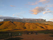
Tepuis tend to be found as isolated entities rather than in connected ranges, which makes them the host of a unique array of endemic
plant and animal species. Some of the most outstanding tepuis are Neblina
, Autana
, Auyantepui
and Mount Roraima. They are typically composed of sheer blocks of Precambrian
quartz arenite sandstone
that rise abruptly from the jungle, giving rise to spectacular natural scenery. Auyantepui
is the source of Angel Falls, the world's tallest waterfall
.
and the Orinoco
, between the Atlantic coast and the Rio Negro. Throughout the course of the history of Earth
, the plateau was eroded, and the tepuis were formed from the remaining monadnock
s.
There are 115 such mesas in the Gran Sabana
in the south-east of Venezuela on the border with Guyana
and Brazil
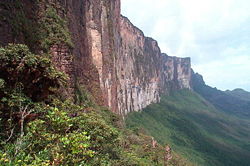
, where the highest concentration of tepuis is found. The precipitous mountain
s tower over the surrounding area by up to 1,000 meters. On top of the mountains grow various types of forests with a wide variety of orchids and bromeliads species.
Because of their great age, some tepuis exhibit surface features and subsurface caves that are typical of more water-soluble rock such as limestone
. Caves here include the 671m deep Abismo Guy Collet
, the deepest quartzite cave in the world. Some of the mesas are pocked with giant sinkhole
s up to 300 metres in diameter and with sheer walls up to 300 metres deep. These sinkholes are formed when the roofs of tunnels carved by underground rivers collapse.
 The plateau of the tepuis is completely isolated from the ground forest, making them ecological island
s. The altitude causes them to have a different climate from the ground forest. The top presents cool temperatures with frequent rainfall, while the bases of the mountains have a tropical, warm and humid climate. The isolation has led to the presence of endemic
flora and fauna through evolution over millennia of a different world of animal and plants, cut off from the rest of the world by the imposing rock walls. Some tepui sinkholes contain species that have evolved in these "islands within islands" that are unique to that sinkhole. The tepuis are often referred to as the Galápagos Islands
of the mainland, having a large number of unique plants and animals not found anywhere else in the world. The floors of the mesas are poor in nutrients, which has led to a rich variety of carnivorous plants. The weathered, craggy nature of the rocky ground means no layers of humus are formed.
The tepuis, also known as 'islands above the rainforest', are a challenge for researchers, as they are home to a high number of new species which have yet to be described. A few of these mountains are cloaked by thick clouds almost the whole year round. Their surfaces could previously only be photographed by helicopter radar equipment. Humans have still yet to set foot on many of the tepuis.
Many tepuis are in the Canaima National Park
in Venezuela, which has been classified as a World Heritage Site
by UNESCO.
 A few of the most notable of the 115 tepuis:
Table (landform)
A table, when used in reference to landforms, is a hill, flank of a mountain, or mountain, that has a flat top.This landform has numerous names in addition to "table", including:*Tuya*Tepui*Mesa*Potrero*Butte*Plateau*Terrace-Description:...
or mesa
Mesa
A mesa or table mountain is an elevated area of land with a flat top and sides that are usually steep cliffs. It takes its name from its characteristic table-top shape....
found in the Guiana Highlands of South America
South America
South America is a continent situated in the Western Hemisphere, mostly in the Southern Hemisphere, with a relatively small portion in the Northern Hemisphere. The continent is also considered a subcontinent of the Americas. It is bordered on the west by the Pacific Ocean and on the north and east...
, especially in Venezuela
Venezuela
Venezuela , officially called the Bolivarian Republic of Venezuela , is a tropical country on the northern coast of South America. It borders Colombia to the west, Guyana to the east, and Brazil to the south...
. The word tepui means "house of the gods" in the native tongue of the Pemon, the indigenous people
Indigenous peoples of the Americas
The indigenous peoples of the Americas are the pre-Columbian inhabitants of North and South America, their descendants and other ethnic groups who are identified with those peoples. Indigenous peoples are known in Canada as Aboriginal peoples, and in the United States as Native Americans...
who inhabit the Gran Sabana
La Gran Sabana
The Gran Sabana is an important natural attraction in Venezuela, located in the south of Bolívar State on the Venezuelan-Brazilian border, approximately 1,400 km from Caracas. The area has a tropical humid climate with an average temperature of 28 °C, but at night it can go down to 13 °C...
.
Tepuis tend to be found as isolated entities rather than in connected ranges, which makes them the host of a unique array of endemic
Endemic (ecology)
Endemism is the ecological state of being unique to a defined geographic location, such as an island, nation or other defined zone, or habitat type; organisms that are indigenous to a place are not endemic to it if they are also found elsewhere. For example, all species of lemur are endemic to the...
plant and animal species. Some of the most outstanding tepuis are Neblina
Neblina massif
The Neblina massif is a sandstone mountain located in the Northern Amazon Basin. The massif is a tilted, heavily eroded plateau, with a deep canyon in its central portion , drained by the Baria River...
, Autana
Autana
Autana, the tree of life, is a spectacular tepui located in the Amazonas state in Venezuela, part of the Guiana Shield. It stands 1,220 m above sea level. A unique cave runs from one side of the mountain through the other. Boat trips are available from Puerto Ayacucho . Allow at least 3 days for...
, Auyantepui
Auyantepui
Auyantepui, also Auyantepuy, Auyan-Tepui, or Aiyan-Tepui, is a tepui plateau in the Gran Sabana region of the Bolivar State in Venezuela. It is one of the largest tepuis in the Guiana Highlands, with an area of .Angel Falls, the tallest waterfall in the world, drops from a cleft near the summit...
and Mount Roraima. They are typically composed of sheer blocks of Precambrian
Precambrian
The Precambrian is the name which describes the large span of time in Earth's history before the current Phanerozoic Eon, and is a Supereon divided into several eons of the geologic time scale...
quartz arenite sandstone
Sandstone
Sandstone is a sedimentary rock composed mainly of sand-sized minerals or rock grains.Most sandstone is composed of quartz and/or feldspar because these are the most common minerals in the Earth's crust. Like sand, sandstone may be any colour, but the most common colours are tan, brown, yellow,...
that rise abruptly from the jungle, giving rise to spectacular natural scenery. Auyantepui
Auyantepui
Auyantepui, also Auyantepuy, Auyan-Tepui, or Aiyan-Tepui, is a tepui plateau in the Gran Sabana region of the Bolivar State in Venezuela. It is one of the largest tepuis in the Guiana Highlands, with an area of .Angel Falls, the tallest waterfall in the world, drops from a cleft near the summit...
is the source of Angel Falls, the world's tallest waterfall
Waterfall
A waterfall is a place where flowing water rapidly drops in elevation as it flows over a steep region or a cliff.-Formation:Waterfalls are commonly formed when a river is young. At these times the channel is often narrow and deep. When the river courses over resistant bedrock, erosion happens...
.
Morphology
These table-top mountains are the remains of a large sandstone plateau that once covered the granite basement complex between the north border of the Amazon BasinAmazon Basin
The Amazon Basin is the part of South America drained by the Amazon River and its tributaries that drains an area of about , or roughly 40 percent of South America. The basin is located in the countries of Bolivia, Brazil, Colombia, Ecuador, Guyana, Peru, and Venezuela...
and the Orinoco
Orinoco
The Orinoco is one of the longest rivers in South America at . Its drainage basin, sometimes called the Orinoquia, covers , with 76.3% of it in Venezuela and the remainder in Colombia...
, between the Atlantic coast and the Rio Negro. Throughout the course of the history of Earth
History of Earth
The history of the Earth describes the most important events and fundamental stages in the development of the planet Earth from its formation 4.578 billion years ago to the present day. Nearly all branches of natural science have contributed to the understanding of the main events of the Earth's...
, the plateau was eroded, and the tepuis were formed from the remaining monadnock
Monadnock
A monadnock or inselberg is an isolated rock hill, knob, ridge, or small mountain that rises abruptly from a gently sloping or virtually level surrounding plain...
s.
There are 115 such mesas in the Gran Sabana
La Gran Sabana
The Gran Sabana is an important natural attraction in Venezuela, located in the south of Bolívar State on the Venezuelan-Brazilian border, approximately 1,400 km from Caracas. The area has a tropical humid climate with an average temperature of 28 °C, but at night it can go down to 13 °C...
in the south-east of Venezuela on the border with Guyana
Guyana
Guyana , officially the Co-operative Republic of Guyana, previously the colony of British Guiana, is a sovereign state on the northern coast of South America that is culturally part of the Anglophone Caribbean. Guyana was a former colony of the Dutch and of the British...
and Brazil
Brazil
Brazil , officially the Federative Republic of Brazil , is the largest country in South America. It is the world's fifth largest country, both by geographical area and by population with over 192 million people...
, where the highest concentration of tepuis is found. The precipitous mountain
Mountain
Image:Himalaya_annotated.jpg|thumb|right|The Himalayan mountain range with Mount Everestrect 58 14 160 49 Chomo Lonzorect 200 28 335 52 Makalurect 378 24 566 45 Mount Everestrect 188 581 920 656 Tibetan Plateaurect 250 406 340 427 Rong River...
s tower over the surrounding area by up to 1,000 meters. On top of the mountains grow various types of forests with a wide variety of orchids and bromeliads species.
Because of their great age, some tepuis exhibit surface features and subsurface caves that are typical of more water-soluble rock such as limestone
Limestone
Limestone is a sedimentary rock composed largely of the minerals calcite and aragonite, which are different crystal forms of calcium carbonate . Many limestones are composed from skeletal fragments of marine organisms such as coral or foraminifera....
. Caves here include the 671m deep Abismo Guy Collet
Abismo Guy Collet
The Abismo Guy Collet is the deepest cave in South America, and the deepest in the world that is formed in quartzite. Located in a tepui in northern Brazil near the border with Venezuela, this cave was first explored by cavers in 2006 to a depth of -671 meters....
, the deepest quartzite cave in the world. Some of the mesas are pocked with giant sinkhole
Sinkhole
A sinkhole, also known as a sink, shake hole, swallow hole, swallet, doline or cenote, is a natural depression or hole in the Earth's surface caused by karst processes — the chemical dissolution of carbonate rocks or suffosion processes for example in sandstone...
s up to 300 metres in diameter and with sheer walls up to 300 metres deep. These sinkholes are formed when the roofs of tunnels carved by underground rivers collapse.
Flora and fauna
Ecological island
An ecological island is not necessarily an island surrounded by water, but is an area of land, isolated by natural or artificial means from the surrounding land, where a natural micro-habitat exists amidst a larger differing ecosystem....
s. The altitude causes them to have a different climate from the ground forest. The top presents cool temperatures with frequent rainfall, while the bases of the mountains have a tropical, warm and humid climate. The isolation has led to the presence of endemic
Endemic (ecology)
Endemism is the ecological state of being unique to a defined geographic location, such as an island, nation or other defined zone, or habitat type; organisms that are indigenous to a place are not endemic to it if they are also found elsewhere. For example, all species of lemur are endemic to the...
flora and fauna through evolution over millennia of a different world of animal and plants, cut off from the rest of the world by the imposing rock walls. Some tepui sinkholes contain species that have evolved in these "islands within islands" that are unique to that sinkhole. The tepuis are often referred to as the Galápagos Islands
Galápagos Islands
The Galápagos Islands are an archipelago of volcanic islands distributed around the equator in the Pacific Ocean, west of continental Ecuador, of which they are a part.The Galápagos Islands and its surrounding waters form an Ecuadorian province, a national park, and a...
of the mainland, having a large number of unique plants and animals not found anywhere else in the world. The floors of the mesas are poor in nutrients, which has led to a rich variety of carnivorous plants. The weathered, craggy nature of the rocky ground means no layers of humus are formed.
The tepuis, also known as 'islands above the rainforest', are a challenge for researchers, as they are home to a high number of new species which have yet to be described. A few of these mountains are cloaked by thick clouds almost the whole year round. Their surfaces could previously only be photographed by helicopter radar equipment. Humans have still yet to set foot on many of the tepuis.
Many tepuis are in the Canaima National Park
Canaima National Park
Canaima National Park is a 30,000 km² park in south-eastern Venezuela that borders Brazil and Guyana. It is located in Bolívar State, and roughly occupies the same area as the Gran Sabana region....
in Venezuela, which has been classified as a World Heritage Site
World Heritage Site
A UNESCO World Heritage Site is a place that is listed by the UNESCO as of special cultural or physical significance...
by UNESCO.
Selected tepuis
- AuyantepuiAuyantepuiAuyantepui, also Auyantepuy, Auyan-Tepui, or Aiyan-Tepui, is a tepui plateau in the Gran Sabana region of the Bolivar State in Venezuela. It is one of the largest tepuis in the Guiana Highlands, with an area of .Angel Falls, the tallest waterfall in the world, drops from a cleft near the summit...
is the largest of the tepuis with a surface area of 700 km². Angel Falls, the highest waterfall in the world, drops from a cleft in the summit. - Mount RoraimaMonte RoraimaMount Roraima is the highest of the Pakaraima chain of tepui plateau in South America. First described by the English explorer Sir Walter Raleigh in 1596, its summit area is defended by 400-metre-tall cliffs on all sides...
, also known as Roraima Tepui. A report by the noted South American researcher Robert SchomburgkRobert Hermann SchomburgkSir Robert Hermann Schomburgk , was a German-born explorer for Great Britain who carried out geographical, ethnological and botanical studies in South America and the West Indies, and also fulfilled diplomatic missions for Great Britain in the Dominican Republic and Thailand.-Biography:Schomburgk...
inspired the Scottish author Arthur Conan DoyleArthur Conan DoyleSir Arthur Ignatius Conan Doyle DL was a Scottish physician and writer, most noted for his stories about the detective Sherlock Holmes, generally considered a milestone in the field of crime fiction, and for the adventures of Professor Challenger...
to write his novel The Lost World about the discovery of a living prehistoric world full of dinosaurs and primeval plants. The borders of VenezuelaVenezuelaVenezuela , officially called the Bolivarian Republic of Venezuela , is a tropical country on the northern coast of South America. It borders Colombia to the west, Guyana to the east, and Brazil to the south...
, BrazilBrazilBrazil , officially the Federative Republic of Brazil , is the largest country in South America. It is the world's fifth largest country, both by geographical area and by population with over 192 million people...
, and GuyanaGuyanaGuyana , officially the Co-operative Republic of Guyana, previously the colony of British Guiana, is a sovereign state on the northern coast of South America that is culturally part of the Anglophone Caribbean. Guyana was a former colony of the Dutch and of the British...
meet on the top. - Matawi TepuiKukenan TepuiKukenan is a tepui in Guayana Region, Venezuela. It is 2,680m high and about 3 km long. The 674m high Kukenan Falls is located at the south end of the tepui....
, also known as Kukenán, because it is the source of the Kukenán River, is considered the "place of the dead" by the local Pemon Indians. Located next to Mount Roraima in Venezuela. - Autana TepuiAutanaAutana, the tree of life, is a spectacular tepui located in the Amazonas state in Venezuela, part of the Guiana Shield. It stands 1,220 m above sea level. A unique cave runs from one side of the mountain through the other. Boat trips are available from Puerto Ayacucho . Allow at least 3 days for...
stands 1,300 m above the forest floor. A unique caveCaveA cave or cavern is a natural underground space large enough for a human to enter. The term applies to natural cavities some part of which is in total darkness. The word cave also includes smaller spaces like rock shelters, sea caves, and grottos.Speleology is the science of exploration and study...
runs from one side of the mountain to the other. - Ptari Tepui's sheer rock walls are so isolated, it is believed a high number of endemic plant and animal species could be found there.
- SarisariñamaSarisariñamaThe Sarisariñama tepui is a mountain in the Jaua-Sarisariñama National Park at the far south-west of Bolívar State, Venezuela, near the border with Brazil. Altitude: 300 - 2,350 metres. The name of the mountain originates from the tale of local Ye'kuana Indians about an evil spirit living in caves...
Tepui, famous for its almost perfectly circular sinkholes which go straight down from the mountain top - the largest such sinkhole is 350 meters in diameter and depth (purportedly created by groundwater erosion). They harbor an ecosystem composed of unique plant and animal species at the bottom.
External links
- http://www.worldwildlife.org/wildworld/profiles/terrestrial/nt/nt0169_full.html
- The Making of the Tepuis Film : "The Living Edens : The Lost World"
- Mongabay.com -- pictures from Tepuis in Venezuela.