

Tashkurgan
Encyclopedia
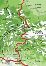
Karakoram Highway
Karakoram Highway
The Karakoram Highway is the highest paved international road in the world, but at its peak at the China-Pakistan border it is only paved on the Chinese side. It connects China and Pakistan across the Karakoram mountain range, through the Khunjerab Pass, at an altitude of as confirmed by both...
which follows the old Silk Road
Silk Road
The Silk Road or Silk Route refers to a historical network of interlinking trade routes across the Afro-Eurasian landmass that connected East, South, and Western Asia with the Mediterranean and European world, as well as parts of North and East Africa...
route from China to Pakistan
Pakistan
Pakistan , officially the Islamic Republic of Pakistan is a sovereign state in South Asia. It has a coastline along the Arabian Sea and the Gulf of Oman in the south and is bordered by Afghanistan and Iran in the west, India in the east and China in the far northeast. In the north, Tajikistan...
. Accommodation is available and it is a recommended overnight stop for road travellers from China
China
Chinese civilization may refer to:* China for more general discussion of the country.* Chinese culture* Greater China, the transnational community of ethnic Chinese.* History of China* Sinosphere, the area historically affected by Chinese culture...
to Pakistan
Pakistan
Pakistan , officially the Islamic Republic of Pakistan is a sovereign state in South Asia. It has a coastline along the Arabian Sea and the Gulf of Oman in the south and is bordered by Afghanistan and Iran in the west, India in the east and China in the far northeast. In the north, Tajikistan...
in order to have the best chance of crossing the snow-prone Khunjerab Pass
Khunjerab Pass
Khunjerab Pass is a high mountain pass in the Karakoram Mountains in a strategic position on the northern border of Pakistan's Gilgit-Baltistan region within the disputed region of Kashmir and on the southwest border of the Xinjiang region of China...
in daylight. Special registration with the police must be made before entering the Tashkurgan, and Chinese citizens must receive written permission from their local police department before entering the region.
Travelling from China, it is about 230 kilometres (142.9 mi) south of Kashgar
Kashgar
Kashgar or Kashi is an oasis city with approximately 350,000 residents in the western part of the Xinjiang Uyghur Autonomous Region of the People's Republic of China. Kashgar is the administrative centre of Kashgar Prefecture which has an area of 162,000 km² and a population of approximately...
and is the last town before the border with Pakistan
Pakistan
Pakistan , officially the Islamic Republic of Pakistan is a sovereign state in South Asia. It has a coastline along the Arabian Sea and the Gulf of Oman in the south and is bordered by Afghanistan and Iran in the west, India in the east and China in the far northeast. In the north, Tajikistan...
, and 120 kilometres (74.6 mi) over the Khunjerab Pass
Khunjerab Pass
Khunjerab Pass is a high mountain pass in the Karakoram Mountains in a strategic position on the northern border of Pakistan's Gilgit-Baltistan region within the disputed region of Kashmir and on the southwest border of the Xinjiang region of China...
from Sust
Sust
Sust or Sost is a dry port in Gojal region of the Northern Areas of Pakistan. It is the last town inside Pakistan on the Karakoram Highway before the Chinese border...
, which is the Pakistani border crossing town. Passenger road service between Tashkurgan and the Pakistani towns of Sust and Gilgit
Gilgit
Gilgit is a city in northern PakistanGilgit may refer to other terms related with the area of the city:* Gilgit River* Gilgit Valley* Gilgit District* Gilgit Agency * Gilgit Airport...
has existed for many years, and road service between Kashgar and Gilgit (via Tashkurgan and Sust) started in summer 2006. However, the border crossing between China and Pakistan at Khunjerab Pass (the highest border of the world) is open only between May 1 and October 15. During winter, the roads are blocked by snow.
External links
- documentary on the Silk Road
- another travel account
- http://depts.washington.edu/silkroad/texts/hhshu/hou_han_shu.html#sec20 Check out note 20.2. to the translation of the Hou Hanshu by John Hill. http://depts.washington.edu/silkroad/texts/hhshu/hou_han_shu.html
- www.gotravelchina.co.uk
- http://www.silkroadcn.com/kashgar/Taxkorgan.htm For a brief description and some photos.
- PIA Northern Areas Page
- www.chinatour.com