

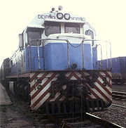
Tanzania-Zambia Railway Authority
Encyclopedia
Landlocked
A landlocked country is a country entirely enclosed by land, or whose only coastlines lie on closed seas. There are 48 landlocked countries in the world, including partially recognized states...
Zambia
Zambia
Zambia , officially the Republic of Zambia, is a landlocked country in Southern Africa. The neighbouring countries are the Democratic Republic of the Congo to the north, Tanzania to the north-east, Malawi to the east, Mozambique, Zimbabwe, Botswana and Namibia to the south, and Angola to the west....
a link to the Tanzania
Tanzania
The United Republic of Tanzania is a country in East Africa bordered by Kenya and Uganda to the north, Rwanda, Burundi, and the Democratic Republic of the Congo to the west, and Zambia, Malawi, and Mozambique to the south. The country's eastern borders lie on the Indian Ocean.Tanzania is a state...
n port of Dar es Salaam
Dar es Salaam
Dar es Salaam , formerly Mzizima, is the largest city in Tanzania. It is also the country's richest city and a regionally important economic centre. Dar es Salaam is actually an administrative province within Tanzania, and consists of three local government areas or administrative districts: ...
, as an alternative to export routes via rail lines to Rhodesia
Rhodesia
Rhodesia , officially the Republic of Rhodesia from 1970, was an unrecognised state located in southern Africa that existed between 1965 and 1979 following its Unilateral Declaration of Independence from the United Kingdom on 11 November 1965...
(now Zimbabwe
Zimbabwe
Zimbabwe is a landlocked country located in the southern part of the African continent, between the Zambezi and Limpopo rivers. It is bordered by South Africa to the south, Botswana to the southwest, Zambia and a tip of Namibia to the northwest and Mozambique to the east. Zimbabwe has three...
), South Africa
South Africa
The Republic of South Africa is a country in southern Africa. Located at the southern tip of Africa, it is divided into nine provinces, with of coastline on the Atlantic and Indian oceans...
, and Mozambique
Mozambique Ports and Railways
Portos e Caminhos de Ferro de Moçambique is the parastatal authority that oversees the railway system of Mozambique and its connected ports. The rail system is composed of a total of 2,983 km rail of the gauge that is compatible with neighboring rail systems...
.
The railroad was a turnkey
Turnkey
A turn-key or a turn-key project is a type of project that is constructed by a developer and sold or turned over to a buyer in a ready-to-use condition.-Common usage:...
project financed and executed by the People's Republic of China
People's Republic of China
China , officially the People's Republic of China , is the most populous country in the world, with over 1.3 billion citizens. Located in East Asia, the country covers approximately 9.6 million square kilometres...
. Total costs were about US $500 million, making it the largest single item foreign-aid project ever undertaken by China.
Genesis
After World War I, TanganyikaTanganyika
Tanganyika , later formally the Republic of Tanganyika, was a sovereign state in East Africa from 1961 to 1964. It was situated between the Indian Ocean and the African Great Lakes of Lake Victoria, Lake Malawi and Lake Tanganyika...
(then German East Africa
German East Africa
German East Africa was a German colony in East Africa, which included what are now :Burundi, :Rwanda and Tanganyika . Its area was , nearly three times the size of Germany today....
) was handed over to the United Kingdom for administration as a League of Nations Mandate
League of Nations mandate
A League of Nations mandate was a legal status for certain territories transferred from the control of one country to another following World War I, or the legal instruments that contained the internationally agreed-upon terms for administering the territory on behalf of the League...
. A railway was envisioned from Northern Rhodesia
Northern Rhodesia
Northern Rhodesia was a territory in south central Africa, formed in 1911. It became independent in 1964 as Zambia.It was initially administered under charter by the British South Africa Company and formed by it in 1911 by amalgamating North-Western Rhodesia and North-Eastern Rhodesia...
(later Zambia) to Tanganyika. However, the plans lay dormant in the worldwide economic depression of the 1930s.
Following World War II, interest in railway construction revived. A map from April 1949 in the Railway Gazette showed a line from Dar es Salaam
Dar es Salaam
Dar es Salaam , formerly Mzizima, is the largest city in Tanzania. It is also the country's richest city and a regionally important economic centre. Dar es Salaam is actually an administrative province within Tanzania, and consists of three local government areas or administrative districts: ...
to Kapiri Mposhi
Kapiri Mposhi
Kapiri Mposhi is a small town in Zambia. Located north of Lusaka, it stands on the Great North Road and is significant for the railway connection between Zambia Railways line from Kitwe to Lusaka and Livingstone and western terminal of the Tanzania-Zambia Railway Authority from Dar-es-Salaam since...
, not far from the route that would eventually be taken by the Chinese railroad. A report in 1952 by Sir Alexander Gibb and Partners concluded that the Northern Rhodesia-Tanganyika railway would not be economically justified, due to the low level of agricultural development and the fact that existing railways through Mozambique and Angola were adequate for carrying copper exports . A World Bank
World Bank
The World Bank is an international financial institution that provides loans to developing countries for capital programmes.The World Bank's official goal is the reduction of poverty...
report in 1964 also concluded that the line was uneconomical, suggesting that a road should be built instead.
Only a year after Zambia's independence, Rhodesia's white-supremacist government issued its Unilateral Declaration of Independence from Britain, threatening Zambia's trade routes. President Nyerere
Julius Nyerere
Julius Kambarage Nyerere was a Tanzanian politician who served as the first President of Tanzania and previously Tanganyika, from the country's founding in 1961 until his retirement in 1985....
of Tanzania and President Kaunda
Kenneth Kaunda
Kenneth David Kaunda, known as KK, served as the first President of Zambia, from 1964 to 1991.-Early life:Kaunda was the youngest of eight children. He was born at Lubwa Mission in Chinsali, Northern Province of Northern Rhodesia, now Zambia...
of Zambia pursued different avenues for the construction of an alternative rail route. Nyerere, after a visit to Beijing, accepted a team of Chinese surveyors, who produced a short report in October 1966. Kaunda was more skeptical of Communist involvement and pursued Western backing. The resulting Canadian-British aerial survey produced a favorable report in July 1966, but Western funding was not forthcoming.
Chairman Mao originally promoted funding the railway, then estimated at 1 billion USD, in order to secure votes against the Soviet Union attending the Asia-Africa summit in Algiers in 1965. After a visit to China in January 1967, Kaunda dropped his objections to Chinese involvement.
Abdulrahman Mohamed Babu
Abdulrahman Mohamed Babu
-Biography:Abdulrahman Mohamed Babu was born in 1924 in Zanzibar, East Africa - then a British protectorate. He described his childhood in a brief autobiographical sketch which was intended to form the basis of memoirs which he had been commissioned to write , but which were always postponed by...
had a key role to play in obtaining Chinese aid for the project. According to his memoirs, Julius Nyerere
Julius Nyerere
Julius Kambarage Nyerere was a Tanzanian politician who served as the first President of Tanzania and previously Tanganyika, from the country's founding in 1961 until his retirement in 1985....
wanted to build on Zanzibar’s close ties with China and create benefits for the whole country. Babu was named head of the trade delegation that preceded Nyerere’s presidential delegation to China in 1964. The outcome of his trip was a trade agreement (separate from the £11 million aid agreement) for £5 million a year for five years. Under this agreement the Tanzanians were to buy whatever they could afford from the Chinese but the Chinese were to buy £5 million worth a year from Tanzania. The Chinese would pay cash for the balance not taken up by purchases from Tanzania. Due to his personal experience with the Chinese and his ideological affinity for their progressive model of development, Babu seized the initiative and mentioned the difficulties his government faced in trying to secure financing for the TAZARA Railway proposal. On 1 July 1965 the Chinese Government made a firm offer of tied aid to the Governments of Tanzania and Zambia, worth £75 million and £150 million to enable them to build the railway line. On September 6, 1967, an agreement was signed in Beijing by the three nations. China committed itself to building a railroad between Tanzania and Zambia, supplying an interest-free loan to be repaid over 30 years.
Construction
Tanzania
The United Republic of Tanzania is a country in East Africa bordered by Kenya and Uganda to the north, Rwanda, Burundi, and the Democratic Republic of the Congo to the west, and Zambia, Malawi, and Mozambique to the south. The country's eastern borders lie on the Indian Ocean.Tanzania is a state...
in a south-west direction. It passes through a largely uninhabited area. Since the line opened, there has been industrial development along the line, including a hydroelectric power plant at Kidatu
Kidatu Dam
Kidatu Dam is a hydroelectric dam located in the Rufiji River Basin in Tanzania. The installed capacity is 200 MW. It has four turbines.The dam was constructed in 1976....
and a paper mill at Rufiji. The line crosses the TAN-ZAM highway at Makambako
Makambako
Makambako is a medium-sized town and ward in Njombe district in the Iringa Region of the Tanzanian Southern Highlands, located roughly 40 miles north of Njombe city by road. It is located at junction of the A104 and B4 roads between Njombe, Iringa, and Mbeya...
and runs parallel toward Mbeya
Mbeya
Mbeya is a city located in southwest Tanzania, Africa. Mbeya's urban population was 280,000 in 2005. Mbeya is the capital of the surrounding rural Mbeya region ....
and the Zambian border, enters Zambia
Zambia
Zambia , officially the Republic of Zambia, is a landlocked country in Southern Africa. The neighbouring countries are the Democratic Republic of the Congo to the north, Tanzania to the north-east, Malawi to the east, Mozambique, Zimbabwe, Botswana and Namibia to the south, and Angola to the west....
, and links to Zambia Railways
Zambia Railways
Zambia Railways is the national railway of Zambia, one of the two major railroad organizations in Zambia, which may also be referred to as Railway Systems of Zambia...
at Kapiri Mposhi
Kapiri Mposhi
Kapiri Mposhi is a small town in Zambia. Located north of Lusaka, it stands on the Great North Road and is significant for the railway connection between Zambia Railways line from Kitwe to Lusaka and Livingstone and western terminal of the Tanzania-Zambia Railway Authority from Dar-es-Salaam since...
. Total length is 1860 kilometres (1,155.8 mi) and the final altitude is 1,400 m.
Running some 1,870 km from Dar es Salaam to Zambia's Kapiri Mposhi the railway is sometimes regarded as the greatest engineering effort of its kind since the Second World War. The railway took only five years to build and was finished ahead of schedule in 1975. Before the railway construction began, 12 Chinese surveyors travelled for nine months on foot from Dar es Salaam to Mbeya in the Southern Highlands to choose and align the railway's path. Thereafter, about 50,000 Tanzanians and 25,000 Chinese were engaged to construct the historical railway.
Braving rain, sun and wind, the workers successfully laid the track through some of Africa's most rugged landscape. The work involved moving 330,000 tonnes of steel rail and the construction of 300 bridges, 23 tunnels and 147 stations. The bridge across the Mpanga River towered 160 feet (48.8 m) in height, and the Irangi Number Tunnel tunnel was one and a half miles long. The section from Mlimba to Makambako was the most difficult of the route, crossing mountains and steep valleys. Almost 30 percent of the bridges, tunnels, viaducts, and earthworks along the entire route were located in a 10 miles (16.1 km) stretch of this section.
Construction camps were set up for each 40 miles (64.4 km) section of track, being relocated as the work progressed. Paw-paw and banana trees were grown to provide shade and food, and workers tended vegetable gardens in the camps in off-hours.
Route
Beginning in Dar es Salaam, the railway cuts through the coastal strip before passing between Mikumi National ParkMikumi National Park
The Mikumi National Park is a national park in Mikumi, near Morogoro, Tanzania. The park was established in 1964, currently covers an area of 3230 km² and is the fourth largest in the country. The park is crossed by Tanzania A-7 highway.-Territory:...
and the vast Selous Game Reserve
Selous Game Reserve
The Selous Game Reserve is one of the largest faunal reserves of the world, located in the south of Tanzania. It was named after Englishman Sir Frederick Selous, a famous big game hunter and early conservationist, who died at Beho Beho in this territory in 1917 while fighting against the Germans...
.
Travellers get the opportunity to see Selous' abundance of game - giraffe, elephant, zebra, antelope and warthog, which with time are now used to the rumbling noise of the train. After the Selous, the railway cuts through the fertile Kilombero Valley. It skirts the great Kibasira Swamp before tackling the greatest challenging area between Mlimba (the Kingdom of Elephants) and Makambako (the Place of Bulls). This is the place where constructors of the railway met the greatest challenge. With the altitude rising 2,500m through contorted mountains, precipitous valleys and deep swamps, it was necessary to construct 18 tunnels, which cross four major rivers. Because of the heavy rainfall experienced in this area, intricate drainage works had to be integrated with every feature. At one stage the railway runs over an aquatic. But perhaps, the most spectacular feature is the bridge across Mpanga River valley, which stands above the river on three 50m tall pillars.
After climbing the Southern Highlands, the railway levels out onto a rolling plateau. Here the weather becomes noticeably cooler, the air sharper. This is the coffee and tea country of Njombe
Njombe
Njombe is one of the 7 districts of the Iringa Region of Tanzania. It is bordered to the North by the Mufindi District, to the South by the Ludewa District, to the East by the Morogoro and Ruvuma Regions, to the West by the Makete District and to the Northwest by the Mbeya Region.According to the...
with large estates punctuated only by groves of bamboo and fields of maize. During the months of June and July, frost, and even an occasional sprinkling of snow, is not uncommon.
On the approach to Makambako the Udzungwa Mountains National Park
Udzungwa Mountains National Park
Udzungwa Mountains National Park is a national park in Tanzania. The habitats contained within the national park include tropical rainforest, mountain forest, miombo woodland, grassland and steppe. There is a vertical height range of 250–2,576 metres , which incorporates the Udzunga Mountains part...
rise 2,137m to the north, while the Kipengere Range roll ahead to the south. Makambako is one of the meeting points of the railway and the Tanzania-Zambia Highway. Another is the Songea-bound road, making Makambako a busy town where travellers in transit to Songea, Iringa, Dar es Salaam and Mbeya find their connections. The residents of Makambako capitalise on the opportunity to sell their products to travelers. Young boys and girls do an enterprising trade in fruits, cooked maize, sweet potatoes, roasted chicken, sugar cane, chewing gum and cigarettes.
From Makambako the railway and the highway run a parallel course towards Mbeya
Mbeya
Mbeya is a city located in southwest Tanzania, Africa. Mbeya's urban population was 280,000 in 2005. Mbeya is the capital of the surrounding rural Mbeya region ....
running past the Kipengere Range that towers to the left. Mostly grassland, with occasional belts of forest along the river courses, they rise to a height of over 2400m. During the wet season, from December to May, this area becomes an enormous carpet of flowers. Travellers by road have the opportunity of stopping to admire some of the more impressive scenic wonders to be found among the southern splendor. For example, from Kitulo a bracing walk may be made to the summit of Chaluhangi (2929m). But perhaps the most rewarding is the walk to the summit of Mtwori, which at 2,961m, is the highest point in the Southern Highlands.
A four-wheel drive vehicle track leading towards Njombe passes near the mountain base. From here a walking track bears left to the ridge of the mountain where a magnificent plateau is covered by monadenium flowers. Visitors are advised, however to arrange for escorts and to inquire about track conditions before setting out.
After the Kipengele Mountains, the Uporoto Range takes over with the Usangu Flats stretching to the right. Many streams cross the highway to empty into these flats where game, which has strayed outside the Ruaha National Park
Ruaha National Park
Ruaha National Park is the largest national park in Tanzania. It covers an area of about 22,000 km². It is located in the middle of Tanzania about 130 km from Iringa...
, may be sighted.
At Chimala
Chimala
Chimala is an administrative ward in the Mbarali district of the Mbeya Region of Tanzania. According to the 2002 census, the ward has a total population of 23,395....
, a track leading south offers a scenic drive to Ntamba
Ntamba
Ntamba is a village in the Commune of Musigati in Bubanza Province in north western Burundi.-External links:*...
in the Uwanji area, where pyrethrum
Pyrethrum
Pyrethrum refers to several Old World plants of the genus Chrysanthemum which are cultivated as ornamentals for their showy flower heads. Pyrethrum is also the name of a natural insecticide made from the dried flower heads of C. cinerariifolium and C...
is cultivated. The woodlands include Brachystegia
Brachystegia
Brachystegia is a genus of tree of the sub-family Caesalpinioideae that is native to tropical Africa. Trees of the genus are commonly known as Miombo, and are the predominant tree in the Miombo woodlands of central and southern Africa.-Species:...
trees, while a variety of flowers, among them the rare Eulophia norlindhii orchid, flourish in the grass beneath the trees. Butterflies and hawk moths add their touch of color. From the top of the Ntamba escarpment one may have a superb view over the Usangu and Buhoro Flats.
These flats form the drainage basin of the Great Ruaha River
Great Ruaha River
The Great Ruaha River is a river in south-central Tanzania that flows through the Usangu wetlands and the Ruaha National Park east into the Rufiji River...
. The flats, which may be explored from Chimala, are a paradise for botanists, lepidopterists and entomologists. From Chimala the highway and the railway pass through a series of scenic delights, including sights of interesting birds such as martins and swifts, waterfalls and stretches of open savannah with flat swampy areas, usually full of flowers, before entering Mbeya town, clustered around verdant hills with the protective backdrop of the Mbeya Range towering over it. From Mbeya town, both the railway and the highway head northwestwards to Tunduma
Tunduma
Tunduma is a Tanzanian border town in Mbeya Region with border posts for both the Tanzam Highway and the TAZARA railway linking the two countries. It is...
where they cross the border into Zambia.
Connection to other systems
The gauge is to match Zambia RailwaysZambia Railways
Zambia Railways is the national railway of Zambia, one of the two major railroad organizations in Zambia, which may also be referred to as Railway Systems of Zambia...
. Zambia Railways are connected to Zimbabwe
Zimbabwe
Zimbabwe is a landlocked country located in the southern part of the African continent, between the Zambezi and Limpopo rivers. It is bordered by South Africa to the south, Botswana to the southwest, Zambia and a tip of Namibia to the northwest and Mozambique to the east. Zimbabwe has three...
, and South Africa
South Africa
The Republic of South Africa is a country in southern Africa. Located at the southern tip of Africa, it is divided into nine provinces, with of coastline on the Atlantic and Indian oceans...
, so that TAZARA is a point of access to the railroad systems of Central and Southern Africa. There was originally no connection with the Tanzania Railways Corporation
Tanzania Railways Corporation
The Tanzania Railways Corporation ' is a state-owned enterprise that runs one of Tanzania's two main railway networks.When the East African Railways and Harbours Corporation was dissolved in 1977 and its assets divided between Kenya, Tanzania and Uganda, TRC was formed to take over EARH's railway,...
system at the port of Dar-es-Salaam. A transshipment
Transshipment
Transshipment or Transhipment is the shipment of goods or containers to an intermediate destination, and then from there to yet another destination....
station has existed at the break of gauge station of Kidatu
Kidatu
Kidatu is a town in southern Tanzania located in Kilombero district, Morogoro Region. The local population is about 3300. Primary economic activity is the large Illovo sugar plantation.Kidatu is a town in central Tanzania...
since 1998.
Standards
- TAZARA uses the American style Janney (AAR) couplingJanney couplerThe Janney coupler, also known as a knuckle coupler, buckeye coupler, alliance coupler and AAR coupler is an automatic coupler patented by Eli H...
. - TAZARA use Air/Vacuum brakes.
There are 22 tunnel
Tunnel
A tunnel is an underground passageway, completely enclosed except for openings for egress, commonly at each end.A tunnel may be for foot or vehicular road traffic, for rail traffic, or for a canal. Some tunnels are aqueducts to supply water for consumption or for hydroelectric stations or are sewers...
s in the Udzungwa Mountains
Udzungwa Mountains
The Udzungwa Mountains are a mountain range south east of Dodoma in Tanzania and are part of the Eastern Arc Mountains. They are covered with tropical rainforest, mountain forest, miombo woodland, grassland, steppe and are home to many large mammals, including the Udzungwa Red Colobus and Tana...
which limit the loading gauge
Loading gauge
A loading gauge defines the maximum height and width for railway vehicles and their loads to ensure safe passage through bridges, tunnels and other structures...
.
Towns served by TAZARA
- Kapiri MposhiKapiri MposhiKapiri Mposhi is a small town in Zambia. Located north of Lusaka, it stands on the Great North Road and is significant for the railway connection between Zambia Railways line from Kitwe to Lusaka and Livingstone and western terminal of the Tanzania-Zambia Railway Authority from Dar-es-Salaam since...
(1258m), link to Zambia Railways - SerenjeSerenjeSerenje is a district in Zambia. There is also the town of Serenje lying just off the Great North Road and TAZARA Railway. The British, during the time that Northern Rhodesia was a British protectorate, designated Serenje as a BOMA . To this day, the locals refer to Serenje Town as the BOMA....
(1424m) - MpikaMpikaMpika is a town in the Northern Province of Zambia, lying at the junction of the Great North Road to Kasama and Mbala and the Tanzam Highway to Dar es Salaam, Tanzania. It also has a railway station on the TAZARA Railway about 5 km away. Mpika is situated between the Muchinga Escarpment to...
(1499m) - Kasama, ZambiaKasama, ZambiaKasama is the capital of the Northern Province of Zambia, situated on the central-southern African plateau at an elevation of about 1400 m. Its population, according to the 2000 census, is approximately 200,000. It grew considerably in the 1970s and 1980s after construction of the TAZARA Railway...
(1240m) - NselukaNseluka- Transport :It has a station on the TAZARA railway. It is the proposed junction for a branch railway to Mpulungu on the shores of Lake Tanganyika....
(1355m) - proposed junction for branch to Port MpulunguMpulunguMpulungu is a town in the Northern Province of Zambia, at the southern tip of Lake Tanganyika.From Mpulungu, boats reach DR Congo, Tanzania and Burundi...
. - TundumaTundumaTunduma is a Tanzanian border town in Mbeya Region with border posts for both the Tanzam Highway and the TAZARA railway linking the two countries. It is...
, Tanzania (1301m) - MbeyaMbeyaMbeya is a city located in southwest Tanzania, Africa. Mbeya's urban population was 280,000 in 2005. Mbeya is the capital of the surrounding rural Mbeya region ....
(1661m) - MlimbaMlimba- Transport :Mlimba is served by a station on the Tanzania Railways Corporation. At the station the line leaves the plains and enters mountainous territory.A proposed railway junctions off at this station according to Railway Gazette International....
(303m) - IfakaraIfakaraIfakara is a small rural town in the Kilombero district, Morogoro region, south central Tanzania. It is the headquarter of the Kilombero district administration and the main trading centre for Kilombero and Ulanga districts...
(192m) - KidatuKidatuKidatu is a town in southern Tanzania located in Kilombero district, Morogoro Region. The local population is about 3300. Primary economic activity is the large Illovo sugar plantation.Kidatu is a town in central Tanzania...
(294m) - minor break of gauge with Tanzanian RailwayCentral Line (Tanzania)The Central Line is the most important railway line in Tanzania apart from TAZARA. It runs west from Dar es Salaam to Kigoma on Lake Tanganyika via Dodoma...
branch - Dar-es-Salaam - ocean port
Significance
The PRC government sponsored construction of the railway specifically to eliminate Zambia's economic dependence on Rhodesia and South Africa. The TAZARA has been a major economic conduit in the region. However, it has never been profitable and more recently it has suffered from competition from road transport (such as the Trans–Caprivi Highway and Walvis Bay Corridor to NamibiaNamibia
Namibia, officially the Republic of Namibia , is a country in southern Africa whose western border is the Atlantic Ocean. It shares land borders with Angola and Zambia to the north, Botswana to the east and South Africa to the south and east. It gained independence from South Africa on 21 March...
) and the re-orientation of Zambia's economic links towards South Africa after the end of apartheid. See following section.
Future of TAZARA
In 2005 the governments of Tanzania and Zambia agreed to privatize TAZARA due to a serious fall in traffic from 1.2mT in 1990 to 630kT in 2003 and a need for $25m worth of locomotive repairs.Officials of the governments opened meetings on April 20, 2006. While the method of privatization was not determined at that time, officials stated that Chinese
People's Republic of China
China , officially the People's Republic of China , is the most populous country in the world, with over 1.3 billion citizens. Located in East Asia, the country covers approximately 9.6 million square kilometres...
interests may be given priority due to their previous involvement in the railway. As of October 2008, a Tanzanian newspaper described the railway's condition as being "on the verge of collapse due to financial crisis", with the company being three months late on paying worker's wages and most of its 12 locomotives being out of service.
At the beginning of 2010 the Chinese government has given the financially crippled Tanzania-Zambia Railways Authority (TAZARA) US$39 million interest-free loan to revive its operations.
See also
- East African Railway Master PlanEast African Railway Master PlanThe East African Railway Master Plan is a proposal for rejuvenating existing railways serving Tanzania, Kenya, Uganda and extending them initially to Rwanda and Burundi and eventually to South Sudan, Ethiopia and beyond...
- Tanzania Railways CorporationTanzania Railways CorporationThe Tanzania Railways Corporation ' is a state-owned enterprise that runs one of Tanzania's two main railway networks.When the East African Railways and Harbours Corporation was dissolved in 1977 and its assets divided between Kenya, Tanzania and Uganda, TRC was formed to take over EARH's railway,...
- Transport in TanzaniaTransport in TanzaniaTransport in Tanzania is mainly by road, supplemented by rail. Tanzania's road network, is of limited quality and not many roads are tarmacked. Dirt roads become impassable during the rainy season and can remain impassable for days, or, more often, weeks. The only reliable surface connection from...
- Transport in ZambiaTransport in Zambia-Railways in Zambia:Total: 2,164 km -Zambia Rail Network Map:-Principal lines:* Zambia Railways Limited — narrow gauge, 846 km Kitwe-Ndola-New Kapiri Mposhi-Kabwe-Lusaka-Livingstone-Zimbabwe with several freight branches mostly in the Copperbelt totalling 427 km including to DR Congo...
- Zambia RailwaysZambia RailwaysZambia Railways is the national railway of Zambia, one of the two major railroad organizations in Zambia, which may also be referred to as Railway Systems of Zambia...
- Li Bao Qi
Maps
External links
- Official website of TAZARA
- Freedom Railway, Jamie Monson, Boston Review, December 2004/January 2005