

Tanasi
Encyclopedia
Tanasi is a historic Overhill Cherokee
village site in Monroe County, Tennessee, in the southeastern United States. The village is best known as the namesake for the state of Tennessee
. Although now submerged by the Tellico Lake impoundment of the Little Tennessee River
, Tanasi served as the de facto capital of the Cherokee
from as early as 1721 until 1730, when the capital shifted to Great Tellico
.
The town of Chota
developed immediately north of Tanasi (the two sites were divided by an unnamed stream) and by the 1740s had become the more prominent of the two towns. Although Chota and Tanasi had distinct political, social, and demographic traits, excavators in the late 1960s determined that the two towns are archaeologically indistinguishable. The two towns are grouped as a single listing on the National Register of Historic Places
, although Tanasi was given its own site designation (40MR62) in 1972.
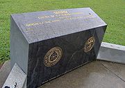
In the 1980s, the Tennessee Valley Authority
placed a monument on the shoreline above the submerged site of Tanasi that commemorates its history and its legacy as the origin of the name Tennessee. This monument is approximately 12 miles (19.3 km) south of Vonore, just off Hwy. 455 (Citico Road). The site is managed by the Eastern Band of the Cherokee Nation
.
and traverses a 40 miles (64.4 km) stretch of northern Monroe County before emptying into the Tennessee River
near Lenoir City
. In 1979, the construction of Tellico Dam
at the mouth of the river created a reservoir that spans the lower 33 miles (53.1 km) of the Little Tennessee and the lower 22 miles (35.4 km) of its tributary, the Tellico River
. Tanasi is located along the west bank of the Little Tennessee 27 miles (43.5 km) upstream from the river's mouth. The site is opposite a sharp bend in the river known as Bacon's Bend.
Before inundation, Tanasi was situated on a relatively flat terrace flanked by the river on one side and a series of high, steep hills on the other. These hills, noted on Timberlake's 1762 map, are part of the Appalachian Ridge-and-Valley Province
, which spans much of the upper Tennessee Valley
. The Appalachian Range
proper rises a few miles south of the Chota-Tanasi site.
reported that the meaning of the town's name is unknown, but noted its occurrence elsewhere among Cherokee lands in Tennessee and North Carolina. The Cherokee
name for the river upon which Tanasi was situated was probably "Callamaco," but early Euro-American explorers and traders renamed the river after Tanasi.
 Among the earliest English agents to reside at Tanasi was Eleazar Wiggan— nicknamed "Old Rabbit" by the Cherokee— who operated out of Tanasi as early as 1711 and would serve as a guide for later diplomats and emissaries. In 1725, South Carolina dispatched Colonel George Chicken to Tanasi to obtain Cherokee assistance in the colony's struggles with the Creeks. Chicken indicated in his journals that the chief of Tanasi— known as the Tanasi Warrior or Head Warrior of Tanasi— ruled over the Cherokee Overhill, Middle, and Valley towns in the region. Chicken recorded a speech in which the Tanasi Warrior pledged support for the English, and the two later engaged in a pipe-smoking session in which the Tanasi Warrior told Chicken of recent Creek hostilities in the area. Colonel John Herbert visited Tanasi on a similar mission in 1727, and reported meeting with the "King and Long Warriour" of Tanasi at the Tanasi townhouse.
In 1730, Sir Alexander Cuming— claiming to be an emissary of King George II— made an ambitious journey to Tanasi in which he managed to obtain the Tanasi Warrior's allegiance for England. As evidence of his success Cuming sought an esteemed symbolic headdress known as the Crown of Tanasi— described as resembling a wig made of dyed possum hair— which he hoped to present to the king of England. To obtain this headdress, Cuming enlisted the aide of Moytoy, chief of Great Tellico. Cuming used his flamboyance and influence to convince the Cherokee to crown Moytoy "Emperor of the Cherokee," and in exchange, Moytoy obtained the headdress sought by Cuming. Cuming departed for England shortly thereafter, taking with him a party that included Eleazar Wiggan, future Cherokee leader Attakullakulla
, and two Tanasi warriors named Clogoittah and Oukanaekah.
The crowning of Moytoy in 1730 shifted the Cherokee center of power to Great Tellico, which was situated along the Tellico River roughly 16 miles (25.7 km) southwest of Tanasi. After the death of Moytoy in 1741, however, Old Hop, the chief of Chota, began to consolidate power. The influence of Chota soon overshadowed that of Tanasi, and by the early 1750s, Chota was clearly the more dominant town. In 1765, Henry Timberlake
, who had visited the Overhill towns as an emissary in 1761-1762, reported 12 dwellings and 21 warriors at Tanasi, and identified Old Hop as chief of both Chota and Tanasi. In 1775, the Tanasi Warrior was among the chiefs who signed a treaty with the Watauga Association
.
Chota doesn't appear in the historical record until around 1745, whereas Tanasi existed when Euro-American traders first reported on the region in the early 18th century. The maps of John Herbert and George Hunter, drawn in 1727 and 1730, respectively, show Tanasi but not Chota. In 1746, English agent George Pawley met with Cherokee leaders at the Chota townhouse, indicating Chota had already usurped Tanasi as the more dominant town. Missionary William Richardson visited the Overhill towns in the late 1750s and described Chota and Tanasi as being separated by a "small river." Richardson's description is supported by Timberlake's map, which recorded the two towns' situation in 1762.
. Lewis and Kneburg, who were searching for cultural data with which to compare their earlier finds at Hiwassee Island, uncovered 22 burials, 85 pit features, 982 postmolds, and one structure.
Between 1969 and 1974, University of Tennessee archaeologists conducted excavations at the Chota-Tanasi site in anticipation of the flooding of the site by the construction of Tellico Dam. Two excavations— one in 1970 and one in 1972— were focused specifically on Tanasi.
Although artifacts dating to the Archaic period (and even a fluted projectile point dating to the Paleo-Indian period) were uncovered at the Chota-Tanasi sites, excavations were mostly focused on the sites' Cherokee occupation. Along with locating the two village sites, investigators hoped to find evidence that would shed light on the Cherokees' relationship to the region's Mississippian
-era (c. 900-1600 A.D.) occupants.
The 1972 excavations uncovered 191 features, 22 burials, 1005 postmolds, and 6 structures at the Tanasi site alone. Two townhouses were uncovered at the Chota-Tanasi sites, one of which was slightly smaller and older than the other. The older of the two townhouses may have been the Tanasi townhouse, the existence of which was reported by traders and emissaries in the 1720s. However, it's also possible that the older townhouse was an earlier version of the Chota townhouse, and that excavators failed to uncover the Tanasi townhouse. The older townhouse had a diameter of just over 50 feet (15.2 m). In 1986, the remains of the 22 burials uncovered at Tanasi— along with those uncovered at Chota— were reinterred in a burial mound at the Sequoyah Museum near Vonore.
Overhill Cherokee
The term Overhill Cherokee refers to the former Cherokee settlements located in what is now Tennessee in the southeastern United States. The name was given by 18th century European traders and explorers who had to cross the Appalachian Mountains to reach these settlements when traveling from...
village site in Monroe County, Tennessee, in the southeastern United States. The village is best known as the namesake for the state of Tennessee
Tennessee
Tennessee is a U.S. state located in the Southeastern United States. It has a population of 6,346,105, making it the nation's 17th-largest state by population, and covers , making it the 36th-largest by total land area...
. Although now submerged by the Tellico Lake impoundment of the Little Tennessee River
Little Tennessee River
The Little Tennessee River is a tributary of the Tennessee River, approximately 135 miles long, in the Appalachian Mountains in the southeastern United States.-Geography:...
, Tanasi served as the de facto capital of the Cherokee
Cherokee
The Cherokee are a Native American people historically settled in the Southeastern United States . Linguistically, they are part of the Iroquoian language family...
from as early as 1721 until 1730, when the capital shifted to Great Tellico
Great Tellico
Great Tellico was a Cherokee town at the site of present-day Tellico Plains, Tennessee, where the Tellico River emerges from the Appalachian Mountains. Great Tellico was one of the largest Cherokee towns in the region, and had a sister town nearby named Chatuga. Its name in Cherokee is more...
.
The town of Chota
Chota (Cherokee town)
Chota is a historic Overhill Cherokee site in Monroe County, Tennessee, in the southeastern United States. For much of its history, Chota was the most important of the Overhill towns, serving as the de facto capital of the Cherokee people from the late 1740s until 1788...
developed immediately north of Tanasi (the two sites were divided by an unnamed stream) and by the 1740s had become the more prominent of the two towns. Although Chota and Tanasi had distinct political, social, and demographic traits, excavators in the late 1960s determined that the two towns are archaeologically indistinguishable. The two towns are grouped as a single listing on the National Register of Historic Places
National Register of Historic Places
The National Register of Historic Places is the United States government's official list of districts, sites, buildings, structures, and objects deemed worthy of preservation...
, although Tanasi was given its own site designation (40MR62) in 1972.
In the 1980s, the Tennessee Valley Authority
Tennessee Valley Authority
The Tennessee Valley Authority is a federally owned corporation in the United States created by congressional charter in May 1933 to provide navigation, flood control, electricity generation, fertilizer manufacturing, and economic development in the Tennessee Valley, a region particularly affected...
placed a monument on the shoreline above the submerged site of Tanasi that commemorates its history and its legacy as the origin of the name Tennessee. This monument is approximately 12 miles (19.3 km) south of Vonore, just off Hwy. 455 (Citico Road). The site is managed by the Eastern Band of the Cherokee Nation
Eastern Band of Cherokee Indians
The Eastern Band of Cherokee Indians , is a federally recognized Native American tribe in the United States of America, who are descended from Cherokee who remained in the Eastern United States while others moved, or were forced to relocate, to the west in the 19th century. The history of the...
.
Geographical setting
The Little Tennessee River flows northwestward from its source in the Appalachian MountainsAppalachian Mountains
The Appalachian Mountains #Whether the stressed vowel is or ,#Whether the "ch" is pronounced as a fricative or an affricate , and#Whether the final vowel is the monophthong or the diphthong .), often called the Appalachians, are a system of mountains in eastern North America. The Appalachians...
and traverses a 40 miles (64.4 km) stretch of northern Monroe County before emptying into the Tennessee River
Tennessee River
The Tennessee River is the largest tributary of the Ohio River. It is approximately 652 miles long and is located in the southeastern United States in the Tennessee Valley. The river was once popularly known as the Cherokee River, among other names...
near Lenoir City
Lenoir City, Tennessee
Lenoir City is a city in Loudon County, Tennessee, United States. Its population was 8,642 at the 2010 census. It is included in the Knoxville Metropolitan Area....
. In 1979, the construction of Tellico Dam
Tellico Dam
Tellico Dam is a dam built by the Tennessee Valley Authority in Loudon County, Tennessee on the Little Tennessee River just above the main stem of the Tennessee River. It impounds the Tellico Reservoir....
at the mouth of the river created a reservoir that spans the lower 33 miles (53.1 km) of the Little Tennessee and the lower 22 miles (35.4 km) of its tributary, the Tellico River
Tellico River
The Tellico River rises in the westernmost mountains of North Carolina, but it flows mainly through Monroe County, Tennessee. It is a major tributary of the Little Tennessee River and the namesake of Tellico Reservoir, a reservoir created by Tellico Dam, which impounds the lower reaches of the...
. Tanasi is located along the west bank of the Little Tennessee 27 miles (43.5 km) upstream from the river's mouth. The site is opposite a sharp bend in the river known as Bacon's Bend.
Before inundation, Tanasi was situated on a relatively flat terrace flanked by the river on one side and a series of high, steep hills on the other. These hills, noted on Timberlake's 1762 map, are part of the Appalachian Ridge-and-Valley Province
Ridge-and-valley Appalachians
The Ridge-and-Valley Appalachians, also called the Ridge and Valley Province or the Valley and Ridge Appalachians, are a physiographic province of the larger Appalachian division and are also a belt within the Appalachian Mountains extending from southeastern New York through northwestern New...
, which spans much of the upper Tennessee Valley
Tennessee Valley
The Tennessee Valley is the drainage basin of the Tennessee River and is largely within the U.S. state of Tennessee. It stretches from southwest Kentucky to northwest Georgia and from northeast Mississippi to the mountains of Virginia and North Carolina...
. The Appalachian Range
Appalachian Mountains
The Appalachian Mountains #Whether the stressed vowel is or ,#Whether the "ch" is pronounced as a fricative or an affricate , and#Whether the final vowel is the monophthong or the diphthong .), often called the Appalachians, are a system of mountains in eastern North America. The Appalachians...
proper rises a few miles south of the Chota-Tanasi site.
Historical background
Tanasi first appears in the historical record in the early 18th century, at a time when the fur trade between the English and the Cherokee had grown to the extent that it required regulation. Ethnologist James MooneyJames Mooney
James Mooney was an American ethnographer who lived for several years among the Cherokee. He did major studies of Southeastern Indians, as well as those on the Great Plains...
reported that the meaning of the town's name is unknown, but noted its occurrence elsewhere among Cherokee lands in Tennessee and North Carolina. The Cherokee
Cherokee language
Cherokee is an Iroquoian language spoken by the Cherokee people which uses a unique syllabary writing system. It is the only Southern Iroquoian language that remains spoken. Cherokee is a polysynthetic language.-North American etymology:...
name for the river upon which Tanasi was situated was probably "Callamaco," but early Euro-American explorers and traders renamed the river after Tanasi.
In 1730, Sir Alexander Cuming— claiming to be an emissary of King George II— made an ambitious journey to Tanasi in which he managed to obtain the Tanasi Warrior's allegiance for England. As evidence of his success Cuming sought an esteemed symbolic headdress known as the Crown of Tanasi— described as resembling a wig made of dyed possum hair— which he hoped to present to the king of England. To obtain this headdress, Cuming enlisted the aide of Moytoy, chief of Great Tellico. Cuming used his flamboyance and influence to convince the Cherokee to crown Moytoy "Emperor of the Cherokee," and in exchange, Moytoy obtained the headdress sought by Cuming. Cuming departed for England shortly thereafter, taking with him a party that included Eleazar Wiggan, future Cherokee leader Attakullakulla
Attacullaculla
Attakullakulla or Atagulkalu , adopted as an infant into the Cherokee tribe, became their First Beloved Man, serving from 1761 to around 1775...
, and two Tanasi warriors named Clogoittah and Oukanaekah.
The crowning of Moytoy in 1730 shifted the Cherokee center of power to Great Tellico, which was situated along the Tellico River roughly 16 miles (25.7 km) southwest of Tanasi. After the death of Moytoy in 1741, however, Old Hop, the chief of Chota, began to consolidate power. The influence of Chota soon overshadowed that of Tanasi, and by the early 1750s, Chota was clearly the more dominant town. In 1765, Henry Timberlake
Henry Timberlake
Henry Timberlake was a colonial Anglo-American officer, journalist, and cartographer. He was born in Virginia in 1730 and died in England...
, who had visited the Overhill towns as an emissary in 1761-1762, reported 12 dwellings and 21 warriors at Tanasi, and identified Old Hop as chief of both Chota and Tanasi. In 1775, the Tanasi Warrior was among the chiefs who signed a treaty with the Watauga Association
Watauga Association
The Watauga Association was a semi-autonomous government created in 1772 by frontier settlers living along the Watauga River in what is now present day Elizabethton, Tennessee...
.
Tanasi's relationship with Chota
Tanasi's relationship with Chota has long puzzled historians and archaeologists. Some have speculated that the two towns were a single community with two districts and two governments, not unlike the situation that reportedly existed with Great Tellico and Chatuga around the same time. Excavators in the early 1970s noted virtually no differences in the types of cultural materials and features uncovered at the two village sites. 18th-century traders and diplomats, however, clearly identified two separate towns.Chota doesn't appear in the historical record until around 1745, whereas Tanasi existed when Euro-American traders first reported on the region in the early 18th century. The maps of John Herbert and George Hunter, drawn in 1727 and 1730, respectively, show Tanasi but not Chota. In 1746, English agent George Pawley met with Cherokee leaders at the Chota townhouse, indicating Chota had already usurped Tanasi as the more dominant town. Missionary William Richardson visited the Overhill towns in the late 1750s and described Chota and Tanasi as being separated by a "small river." Richardson's description is supported by Timberlake's map, which recorded the two towns' situation in 1762.
Archaeological findings
Cyrus Thomas, working for the Smithsonian Institution's Bureau of Ethnology, conducted a mound survey at the Chota-Tanasi site in the late 1880s. Thomas reported the discovery of 13 burials and several artifacts. In 1939, Thomas Lewis and Madeline Kneburg directed an excavation at the Chota-Tanasi site with the help of the Works Progress AdministrationWorks Progress Administration
The Works Progress Administration was the largest and most ambitious New Deal agency, employing millions of unskilled workers to carry out public works projects, including the construction of public buildings and roads, and operated large arts, drama, media, and literacy projects...
. Lewis and Kneburg, who were searching for cultural data with which to compare their earlier finds at Hiwassee Island, uncovered 22 burials, 85 pit features, 982 postmolds, and one structure.
Between 1969 and 1974, University of Tennessee archaeologists conducted excavations at the Chota-Tanasi site in anticipation of the flooding of the site by the construction of Tellico Dam. Two excavations— one in 1970 and one in 1972— were focused specifically on Tanasi.
Although artifacts dating to the Archaic period (and even a fluted projectile point dating to the Paleo-Indian period) were uncovered at the Chota-Tanasi sites, excavations were mostly focused on the sites' Cherokee occupation. Along with locating the two village sites, investigators hoped to find evidence that would shed light on the Cherokees' relationship to the region's Mississippian
Mississippian culture
The Mississippian culture was a mound-building Native American culture that flourished in what is now the Midwestern, Eastern, and Southeastern United States from approximately 800 CE to 1500 CE, varying regionally....
-era (c. 900-1600 A.D.) occupants.
The 1972 excavations uncovered 191 features, 22 burials, 1005 postmolds, and 6 structures at the Tanasi site alone. Two townhouses were uncovered at the Chota-Tanasi sites, one of which was slightly smaller and older than the other. The older of the two townhouses may have been the Tanasi townhouse, the existence of which was reported by traders and emissaries in the 1720s. However, it's also possible that the older townhouse was an earlier version of the Chota townhouse, and that excavators failed to uncover the Tanasi townhouse. The older townhouse had a diameter of just over 50 feet (15.2 m). In 1986, the remains of the 22 burials uncovered at Tanasi— along with those uncovered at Chota— were reinterred in a burial mound at the Sequoyah Museum near Vonore.