

Tamiami Trail
Encyclopedia
The Tamiami Trail is the southernmost 264 miles (424.9 km) of U.S. Highway 41 from State Road 60
in Tampa
to U.S. Route 1 (SR 5
) in Miami. The road also has the hidden designation of State Road 90.
The 165 miles (265.5 km) north–south section (hidden SR 45
) extends to Naples
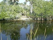
, whereupon it becomes an east–west road (hidden SR 90) crossing the Everglades (and forming part of the northern border of Everglades National Park
) before becoming Southwest Eighth Street in Miami-Dade County
, famous as Calle Ocho in the Little Havana
section of Miami.
At the time, Lee County
was a much larger county (Collier County was created out of Lee County in 1923, along with Hendry County
). In 1919, due to financial reasons, Lee County was not able to complete its portion of the Tamiami Trail. Captain Jaudon had already purchased 207360 acres (839.2 km²) of land, mostly in Monroe County
. His company, the Chevelier Corporation, came to the rescue and offered to build a link of the highway through its holdings in Monroe County if Dade and Lee counties would agree to change the original route and re-route the Tamiami Trail through Monroe County. The proposal was accepted, the Chevelier Corporation began laying out a new route for the road, and in 1921 began construction on the new segment of the Tamiami Trail. This segment is today known as Loop Road (located in Big Cypress National Preserve
).
In 1922, the State of Florida ran out of construction funds for the east–west portion. The following year, Barron Collier
, an advertising mogul who recently diversified his holdings by investing in various types of businesses and millions of acres of southwest Florida wilderness, pledged that he would bankroll the completion of the Tamiami Trail; in return, the State legislature would establish a new county and name it after him.
So in 1923, Collier County was created out of the southern portion of Lee County. Almost immediately contention arose over the change of the route. The sponsors of the new county advocated for the original route which was completely inside the boundaries of Collier County. The State Road Department agreed with Collier County. Even so, the Board of County Commissioners of Dade County gave their support to the Chevelier segment since so much money had already been invested. In fact, only a few miles of road were left to be completed.
Despite this protest, the State Road Department reinstated the original route of the Tamiami Trail to be completed. The already completed portion of roadway in Monroe County was accepted as a "South Loop" of the Tamiami Trail.
As construction of the north–south section resumed, Collier hired A. R. Richardson to be the head engineer of the Naples-to-Miami section (a few months later, A. W. Frederick replaced Richardson, who returned to the Everglades Drainage District), and construction started on the east–west stretch in 1923. An east–west canal was created using explosives; the fill dirt was used to construct the roadway.
In 1926, both the north–south section and the east–west stretch were designated U.S. Highways. Although the Trail was intended to be one road, the two sections received two different numbers: as each section was completed, the north–south portion would receive US 41 signs, and the east–west stretch would be designated US 94 upon completion (to comply with the route numbering guidelines of AASHTO
). In addition, both sections south of Fort Myers would receive the State Road 27 designation.
While a 1927 Rand McNally map indicated the southern terminus to be Fort Myers
, US 41 signs were already up on the completed segment (south to Naples) in late 1926; US 94 signs made their appearances when the final section was completed in April 1928. The Tamiami Trail took 13 years, cost $8 million US, and used 2.6 million sticks of dynamite
in its construction. The Tamiami Trail officially opened on April 25, 1928.
In 1945, a restructuring of Florida’s State Road system resulted in the removal of the SR 27 signs from US 94 and the assignment of the hidden Florida Department of Transportation
designation State Road 90, which continues to be applied to the east–west stretch of highway to this day.
In 1949, the US 94 signage was replaced with US 41 signs, over a decade after AASHTO modified its guidelines to discourage short (under 300 miles) U.S. Routes that are entirely within one state.
.svg.png) In 1950s, the newly-configured US 41 was extended eastward and northward, first to downtown Miami along US 1 in 1950, then to Miami Beach
In 1950s, the newly-configured US 41 was extended eastward and northward, first to downtown Miami along US 1 in 1950, then to Miami Beach
along US 1 and SR A1A
in 1953. In 1965, US 41 was rerouted as a bypass along unsigned SR 45A around Venice Gardens
, while Business US 41 signs grace the three-mile-long former alignment (which is still named Tamiami Trail).
This configuration of US 41 south of Tampa remained intact until the U.S. Highway was truncated to US 1 and Southwest Eighth Street in Miami in 2001 – ironically, the historic eastern terminus of US 94, former SR 27, and current SR 90 (westbound US 41 and SR 90 now begin one block to the north, on Southwest Seventh Street, as the easternmost 2.7 miles (4.3 km) of the U.S. Highway now lie along a one-way pair
).
While US 41 and SR 90 have not significantly changed since the 1960s (aside from the widening to the east of SR 997
in Miami-Dade County in the 1970s and in 2002-2005), its importance to motorists of southeastern Florida
has changed since the opening of Alligator Alley
to the north in 1968. Since then, traffic on the Tamiami Trail across the Everglades has lessened significantly, while urban sections of the road are now often congested.
In 1968, the Dade County Port Authority began construction on what was to become the world's largest airport. The Miami Jetport was located 36 miles (57.9 km) west of Miami, just across the Collier County line. It was to be a six runway supersonic
airport. The project would also transform the Tamiami Trail into a multi-lane expressway
. Conservationists were worried about the impact an airport that size would have on the environment of the Everglades and Big Cypress. After several court hearings, a ban was placed upon further development. The widening of Tamiami Trail as a part of the Jetport had been stopped. One runway had already been completed; so the runway was allowed to be used as a flight training center. The runway remains today as a part of the Dade-Collier Training and Transition Airport
.
Also in 1968, construction of an extension of Interstate 75 south from Tampa to Miami was started, with an eye toward routing the expressway along an upgraded Tamiami Trail from Naples to a soon-to-be completed SR 836
whereupon it would continue on the east–west highway to its intended terminus at an interchange
with Interstate 95
. Plans for the I-75 extension changed for two reasons; Alligator Alley needed upgrading as the then-narrow toll road
was dangerous to both motorists and wildlife (most notably the Florida panther
) alike; and State Road 836, with its left exits and narrow lanes, was not being built to Interstate Highway standards
. As a result, construction for a rerouted I-75 in southern Florida began in 1974, now with I-75 using Alligator Alley instead of US 41 to cross the peninsula, and the configured Interstate highway would not be completed for another 19 years.
Since then, the Tamiami Trail has been designated a National Scenic Byway
by the United States Department of Transportation
for its unique scenery in the Everglades and the Big Cypress National Preserve
.
to Florida Bay
at the southern tip of the peninsula. As a result, the Everglades — the “River of Grass” — has had its water flow greatly diminished over the years, resulting in a devastating effect on the ecology of the region. In the 1990s, a few canal
s were filled and additional culvert
s were constructed under US 41 to help regulate water flow.
Yet, according to the United States Army Corps of Engineers
, this was only a partial solution to the problems of the Everglades and the Tamiami Trail. In 2003, after considering a variety of plans involving the rebuilding of US 41/SR 90, the Corps recommended that a 3000-foot-long causeway
be built near the Northeast Shark Slough northeast of Everglades National Park
, all road fill removed that would otherwise be adjacent to the bridge, the 57 culverts that are already in place maintained, and the appropriate water flow rate maintained under the non-causeway portions of the Tamiami Trail crossing the Everglades. The proposed causeway is being called the Everglades Skyway by the Sierra Club
, Audubon Society, World Wildlife Fund, and other organizations in an Internet-based effort to lobby Florida and United States government officials for project construction money. In December 2009, construction began on the one mile-long bridge (1.6 km) to lift a portion of the road to allow the more natural water flow into the southern Everglades. At the Everglades Foundation’s
America’s Everglades Summit held in mid-May 2010, Assistant Secretary of the U.S. Department of Interior, Thomas Strickland, revealed that the Interior Department's National Park Service released a draft Environmental Impact Statement recommending an additional 5.5 miles of bridging the Tamiami Trail. The Everglades Foundation is a group that supports the Tamiami Trail bridging and dedicated to Everglades restoration.
State Road 60 (Florida)
State Road 60 is an east–west route transversing Florida from the Gulf of Mexico to the Atlantic Ocean. The western terminus of SR 60 is at the Sunsets at Pier 60 in Clearwater...
in Tampa
Tampa, Florida
Tampa is a city in the U.S. state of Florida. It serves as the county seat for Hillsborough County. Tampa is located on the west coast of Florida. The population of Tampa in 2010 was 335,709....
to U.S. Route 1 (SR 5
State Road 5 (Florida)
State Road 5 is a mostly-unsigned state highway in the state of Florida. It is mainly signed as U.S. Route 1 from its south end in Key West, Florida to Jacksonville, Florida, and U.S. Route 17 from Jacksonville to the Georgia state line at the Saint Marys River. U.S...
) in Miami. The road also has the hidden designation of State Road 90.
The 165 miles (265.5 km) north–south section (hidden SR 45
State Road 45 (Florida)
A major north–south highway extending almost the entire length of the Florida peninsula, State Road 45 is the unsigned Florida Department of Transportation designation of most of the current U.S. Route 41 in Florida. The southern terminus of SR 45 is an intersection with SR 951 just east of...
) extends to Naples
Naples, Florida
Naples is a city in Collier County, Florida, United States. As of July 1, 2007, the U.S. Census Bureau estimated the city's population at 21,653. Naples is a principal city of the Naples–Marco Island Metropolitan Statistical Area, which had an estimated total population of 315,839 on July 1, 2007...
, whereupon it becomes an east–west road (hidden SR 90) crossing the Everglades (and forming part of the northern border of Everglades National Park
Everglades National Park
Everglades National Park is a national park in the U.S. state of Florida that protects the southern 25 percent of the original Everglades. It is the largest subtropical wilderness in the United States, and is visited on average by one million people each year. It is the third-largest...
) before becoming Southwest Eighth Street in Miami-Dade County
Miami-Dade County, Florida
Miami-Dade County is a county located in the southeastern part of the state of Florida. As of 2010 U.S. Census, the county had a population of 2,496,435, making it the most populous county in Florida and the eighth-most populous county in the United States...
, famous as Calle Ocho in the Little Havana
Little Havana
Little Havana is a neighborhood of Miami, Florida, United States. Home to many Cuban immigrant residents, Little Havana is named after Havana, the capital and largest city in Cuba. The approximate boundaries are the Miami River , SW 16th Street , SR 9/West 27th Avenue and I-95...
section of Miami.
History
Construction and early designations
Construction on the north–south section was begun in 1915. The east–west portion was originally called the Miami-Marco Road. The following year, Miami’s Capt. James Franklin Jaudon first proposed a road connecting Florida’s Gulf and Atlantic coasts with an eye on developing his properties in the Everglades. The notion was seconded by Tampa’s E.P. Dickey, who also suggested a name, the Tamyami Trail, although D.C. Gillett of Tampa claimed to have originally suggested the name. Tamiami is said to be a contraction of, Tampa to Miami. While support in Tampa for the proposed road was lacking, Miami Herald columnist William Stewart Hill would keep the idea alive whenever he felt that support was waning on the southeastern coast.At the time, Lee County
Lee County, Florida
Lee County is a county located in the U.S. state of Florida. Located in southwest Florida, the principal cities in the county are Fort Myers and Cape Coral...
was a much larger county (Collier County was created out of Lee County in 1923, along with Hendry County
Hendry County, Florida
Hendry County is a county located in the U.S. state of Florida. As of 2000, the population was 36,210. The U.S. Census Bureau 2007 estimate for the county is 39,611 . Its county seat is La Belle. The county comprises the Clewiston, Florida, Micropolitan Statistical Area.-History:Hendry County...
). In 1919, due to financial reasons, Lee County was not able to complete its portion of the Tamiami Trail. Captain Jaudon had already purchased 207360 acres (839.2 km²) of land, mostly in Monroe County
Monroe County, Florida
Monroe County is a county located in the state of Florida. As of 2000, the population was 79,589. The U.S. Census Bureau 2006 estimate for the county was 74,737....
. His company, the Chevelier Corporation, came to the rescue and offered to build a link of the highway through its holdings in Monroe County if Dade and Lee counties would agree to change the original route and re-route the Tamiami Trail through Monroe County. The proposal was accepted, the Chevelier Corporation began laying out a new route for the road, and in 1921 began construction on the new segment of the Tamiami Trail. This segment is today known as Loop Road (located in Big Cypress National Preserve
Big Cypress National Preserve
Big Cypress National Preserve is a United States National Preserve located in southern Florida, about 45 miles west of Miami. The Big Cypress, along with Big Thicket National Preserve in Texas, became the first national preserves in the United States National Park System when they were...
).
In 1922, the State of Florida ran out of construction funds for the east–west portion. The following year, Barron Collier
Barron Collier
Barron Gift Collier was an American advertising entrepreneur, who became the largest landowner and developer in the U.S. state of Florida, as well as, the owner of a chain of hotels, bus lines, several banks, and newspapers. He also owned a telephone company and a steamship line.Collier was born...
, an advertising mogul who recently diversified his holdings by investing in various types of businesses and millions of acres of southwest Florida wilderness, pledged that he would bankroll the completion of the Tamiami Trail; in return, the State legislature would establish a new county and name it after him.
So in 1923, Collier County was created out of the southern portion of Lee County. Almost immediately contention arose over the change of the route. The sponsors of the new county advocated for the original route which was completely inside the boundaries of Collier County. The State Road Department agreed with Collier County. Even so, the Board of County Commissioners of Dade County gave their support to the Chevelier segment since so much money had already been invested. In fact, only a few miles of road were left to be completed.
Despite this protest, the State Road Department reinstated the original route of the Tamiami Trail to be completed. The already completed portion of roadway in Monroe County was accepted as a "South Loop" of the Tamiami Trail.
As construction of the north–south section resumed, Collier hired A. R. Richardson to be the head engineer of the Naples-to-Miami section (a few months later, A. W. Frederick replaced Richardson, who returned to the Everglades Drainage District), and construction started on the east–west stretch in 1923. An east–west canal was created using explosives; the fill dirt was used to construct the roadway.
In 1926, both the north–south section and the east–west stretch were designated U.S. Highways. Although the Trail was intended to be one road, the two sections received two different numbers: as each section was completed, the north–south portion would receive US 41 signs, and the east–west stretch would be designated US 94 upon completion (to comply with the route numbering guidelines of AASHTO
American Association of State Highway and Transportation Officials
AASHTO, the American Association of State Highway and Transportation Officials, is a standards setting body which publishes specifications, test protocols and guidelines which are used in highway design and construction throughout the United States...
). In addition, both sections south of Fort Myers would receive the State Road 27 designation.
While a 1927 Rand McNally map indicated the southern terminus to be Fort Myers
Fort Myers, Florida
Fort Myers is the county seat and commercial center of Lee County, Florida, United States. Its population was 62,298 in the 2010 census, a 29.23 percent increase over the 2000 figure....
, US 41 signs were already up on the completed segment (south to Naples) in late 1926; US 94 signs made their appearances when the final section was completed in April 1928. The Tamiami Trail took 13 years, cost $8 million US, and used 2.6 million sticks of dynamite
Dynamite
Dynamite is an explosive material based on nitroglycerin, initially using diatomaceous earth , or another absorbent substance such as powdered shells, clay, sawdust, or wood pulp. Dynamites using organic materials such as sawdust are less stable and such use has been generally discontinued...
in its construction. The Tamiami Trail officially opened on April 25, 1928.
U.S. 94
Upon the completion of the Tamiami Trail, U.S. Highway 94 extended from the intersection of Ninth Street South and Fifth Avenue South in Naples (the southern terminus of US 41) to the intersection of South Eighth Street and Brickell Avenue (US 1) in Miami. At the time it was considered a major achievement of engineering that was the only route from Naples (and, by extension, from Tampa) to the southeastern coast of Florida.In 1945, a restructuring of Florida’s State Road system resulted in the removal of the SR 27 signs from US 94 and the assignment of the hidden Florida Department of Transportation
Florida Department of Transportation
The Florida Department of Transportation is a decentralized agency charged with the establishment, maintenance, and regulation of public transportation in the state of Florida. The department was formed in 1969. It absorbed the powers of the Florida State Road Department...
designation State Road 90, which continues to be applied to the east–west stretch of highway to this day.
In 1949, the US 94 signage was replaced with US 41 signs, over a decade after AASHTO modified its guidelines to discourage short (under 300 miles) U.S. Routes that are entirely within one state.
U.S. 41 and the Tamiami Trail after US 94
Miami Beach, Florida
Miami Beach is a coastal resort city in Miami-Dade County, Florida, United States, incorporated on March 26, 1915. The municipality is located on a barrier island between the Atlantic Ocean and Biscayne Bay, the latter which separates the Beach from Miami city proper...
along US 1 and SR A1A
State Road A1A (Florida)
State Road A1A is a Florida State Road that runs mostly along the Atlantic Ocean, with sections from Key West at the southern tip of Florida, to Callahan, just south of Georgia. It is the main road through most oceanfront towns. SR A1A is designated the A1A Scenic and Historic Coastal Highway, a...
in 1953. In 1965, US 41 was rerouted as a bypass along unsigned SR 45A around Venice Gardens
Venice Gardens, Florida
Venice Gardens is a census-designated place in Sarasota County, Florida, United States. The population was 7,466 at the 2000 census. It is part of the Bradenton–Sarasota–Venice Metropolitan Statistical Area.-Geography:...
, while Business US 41 signs grace the three-mile-long former alignment (which is still named Tamiami Trail).
This configuration of US 41 south of Tampa remained intact until the U.S. Highway was truncated to US 1 and Southwest Eighth Street in Miami in 2001 – ironically, the historic eastern terminus of US 94, former SR 27, and current SR 90 (westbound US 41 and SR 90 now begin one block to the north, on Southwest Seventh Street, as the easternmost 2.7 miles (4.3 km) of the U.S. Highway now lie along a one-way pair
One-way pair
A one-way pair, one-way couple, or just couplet is a pair of parallel, usually one-way streets that carry opposite directions of a signed route or major traffic flow, or sometimes opposite directions of a bus or streetcar route....
).
While US 41 and SR 90 have not significantly changed since the 1960s (aside from the widening to the east of SR 997
State Road 997 (Florida)
State Road 997, also known as Krome Avenue and West 177 Avenue is a north–south state highway in western Miami-Dade County, Florida. It runs from U.S. Route 1 just south of Florida City north across U.S. Route 41 to U.S. Route 27 near Opa-locka West Airport, just south of the Broward...
in Miami-Dade County in the 1970s and in 2002-2005), its importance to motorists of southeastern Florida
Florida
Florida is a state in the southeastern United States, located on the nation's Atlantic and Gulf coasts. It is bordered to the west by the Gulf of Mexico, to the north by Alabama and Georgia and to the east by the Atlantic Ocean. With a population of 18,801,310 as measured by the 2010 census, it...
has changed since the opening of Alligator Alley
Alligator Alley
Alligator Alley is a section of Interstate 75 and State Road 84 extending from Naples on the west coast of Florida to Weston on the east...
to the north in 1968. Since then, traffic on the Tamiami Trail across the Everglades has lessened significantly, while urban sections of the road are now often congested.
In 1968, the Dade County Port Authority began construction on what was to become the world's largest airport. The Miami Jetport was located 36 miles (57.9 km) west of Miami, just across the Collier County line. It was to be a six runway supersonic
Supersonic
Supersonic speed is a rate of travel of an object that exceeds the speed of sound . For objects traveling in dry air of a temperature of 20 °C this speed is approximately 343 m/s, 1,125 ft/s, 768 mph or 1,235 km/h. Speeds greater than five times the speed of sound are often...
airport. The project would also transform the Tamiami Trail into a multi-lane expressway
Controlled-access highway
A controlled-access highway is a highway designed exclusively for high-speed vehicular traffic, with all traffic flow and ingress/egress regulated...
. Conservationists were worried about the impact an airport that size would have on the environment of the Everglades and Big Cypress. After several court hearings, a ban was placed upon further development. The widening of Tamiami Trail as a part of the Jetport had been stopped. One runway had already been completed; so the runway was allowed to be used as a flight training center. The runway remains today as a part of the Dade-Collier Training and Transition Airport
Dade-Collier Training and Transition Airport
Dade-Collier Training and Transition Airport is a public airport located 36 miles west of the central business district of Miami, in Collier County, Florida, United States. It is owned by Miami-Dade County and operated by the Miami-Dade Aviation Department...
.
Also in 1968, construction of an extension of Interstate 75 south from Tampa to Miami was started, with an eye toward routing the expressway along an upgraded Tamiami Trail from Naples to a soon-to-be completed SR 836
State Road 836 (Florida)
State Road 836, locally known as the Dolphin Expressway, is a 19-mile-long six-lane divided expressway, with the westernmost 14 miles being a tollway, currently extending from just north of the intersection of Southwest 137th Avenue and U.S...
whereupon it would continue on the east–west highway to its intended terminus at an interchange
Interchange (road)
In the field of road transport, an interchange is a road junction that typically uses grade separation, and one or more ramps, to permit traffic on at least one highway to pass through the junction without directly crossing any other traffic stream. It differs from a standard intersection, at which...
with Interstate 95
Interstate 95 in Florida
Interstate 95 is the main Interstate Highway on the east coast of the United States; it serves the Atlantic coast of Florida. It begins at a partial interchange with U.S. Highway 1 just south of downtown Miami, and heads north past Daytona Beach and Jacksonville to the Georgia state line at the St...
. Plans for the I-75 extension changed for two reasons; Alligator Alley needed upgrading as the then-narrow toll road
Toll road
A toll road is a privately or publicly built road for which a driver pays a toll for use. Structures for which tolls are charged include toll bridges and toll tunnels. Non-toll roads are financed using other sources of revenue, most typically fuel tax or general tax funds...
was dangerous to both motorists and wildlife (most notably the Florida panther
Florida Panther
The Florida panther is an endangered subspecies of cougar that lives in forests and swamps of southern Florida in the United States. Its current taxonomic status is unresolved, but recent genetic research alone does not alter the legal conservation status...
) alike; and State Road 836, with its left exits and narrow lanes, was not being built to Interstate Highway standards
Interstate Highway standards
Standards for Interstate Highways in the United States are defined by the American Association of State Highway and Transportation Officials in the publication A Policy on Design Standards - Interstate System...
. As a result, construction for a rerouted I-75 in southern Florida began in 1974, now with I-75 using Alligator Alley instead of US 41 to cross the peninsula, and the configured Interstate highway would not be completed for another 19 years.
Since then, the Tamiami Trail has been designated a National Scenic Byway
National Scenic Byway
A National Scenic Byway is a road recognized by the United States Department of Transportation for its archeological, cultural, historic, natural, recreational, and/or scenic qualities. The program was established by Congress in 1991 to preserve and protect the nation's scenic but often...
by the United States Department of Transportation
United States Department of Transportation
The United States Department of Transportation is a federal Cabinet department of the United States government concerned with transportation. It was established by an act of Congress on October 15, 1966, and began operation on April 1, 1967...
for its unique scenery in the Everglades and the Big Cypress National Preserve
Big Cypress National Preserve
Big Cypress National Preserve is a United States National Preserve located in southern Florida, about 45 miles west of Miami. The Big Cypress, along with Big Thicket National Preserve in Texas, became the first national preserves in the United States National Park System when they were...
.
Plans for the Tamiami Trail
In 1928, the Tamiami Trail was considered a feat of engineering, although no one considered the potential damage to the Everglades by the roadway and the Tamiami Canal. Both have acted as a dam to block water flow from Lake OkeechobeeLake Okeechobee
Lake Okeechobee , locally referred to as The Lake or The Big O, is the largest freshwater lake in the state of Florida. It is the seventh largest freshwater lake in the United States and the second largest freshwater lake contained entirely within the lower 48 states...
to Florida Bay
Florida Bay
Florida Bay is the bay located between the southern end of the Florida mainland and the Florida Keys. Its area is variously stated to be , or , or . Nearly all of Florida Bay is included in Everglades National Park. The southern edge, along the Florida Keys is in the Florida Keys National Marine...
at the southern tip of the peninsula. As a result, the Everglades — the “River of Grass” — has had its water flow greatly diminished over the years, resulting in a devastating effect on the ecology of the region. In the 1990s, a few canal
Canal
Canals are man-made channels for water. There are two types of canal:#Waterways: navigable transportation canals used for carrying ships and boats shipping goods and conveying people, further subdivided into two kinds:...
s were filled and additional culvert
Culvert
A culvert is a device used to channel water. It may be used to allow water to pass underneath a road, railway, or embankment. Culverts can be made of many different materials; steel, polyvinyl chloride and concrete are the most common...
s were constructed under US 41 to help regulate water flow.
Yet, according to the United States Army Corps of Engineers
United States Army Corps of Engineers
The United States Army Corps of Engineers is a federal agency and a major Army command made up of some 38,000 civilian and military personnel, making it the world's largest public engineering, design and construction management agency...
, this was only a partial solution to the problems of the Everglades and the Tamiami Trail. In 2003, after considering a variety of plans involving the rebuilding of US 41/SR 90, the Corps recommended that a 3000-foot-long causeway
Causeway
In modern usage, a causeway is a road or railway elevated, usually across a broad body of water or wetland.- Etymology :When first used, the word appeared in a form such as “causey way” making clear its derivation from the earlier form “causey”. This word seems to have come from the same source by...
be built near the Northeast Shark Slough northeast of Everglades National Park
Everglades National Park
Everglades National Park is a national park in the U.S. state of Florida that protects the southern 25 percent of the original Everglades. It is the largest subtropical wilderness in the United States, and is visited on average by one million people each year. It is the third-largest...
, all road fill removed that would otherwise be adjacent to the bridge, the 57 culverts that are already in place maintained, and the appropriate water flow rate maintained under the non-causeway portions of the Tamiami Trail crossing the Everglades. The proposed causeway is being called the Everglades Skyway by the Sierra Club
Sierra Club
The Sierra Club is the oldest, largest, and most influential grassroots environmental organization in the United States. It was founded on May 28, 1892, in San Francisco, California, by the conservationist and preservationist John Muir, who became its first president...
, Audubon Society, World Wildlife Fund, and other organizations in an Internet-based effort to lobby Florida and United States government officials for project construction money. In December 2009, construction began on the one mile-long bridge (1.6 km) to lift a portion of the road to allow the more natural water flow into the southern Everglades. At the Everglades Foundation’s
Everglades Foundation
-History:The Everglades Foundation was formed by a group of outdoor enthusiasts, environmentalists and residents of Florida who were concerned over the decline of the Everglades and the resulting damage in the nearby natural and protected areas such as Florida Bay...
America’s Everglades Summit held in mid-May 2010, Assistant Secretary of the U.S. Department of Interior, Thomas Strickland, revealed that the Interior Department's National Park Service released a draft Environmental Impact Statement recommending an additional 5.5 miles of bridging the Tamiami Trail. The Everglades Foundation is a group that supports the Tamiami Trail bridging and dedicated to Everglades restoration.
Major intersections
| County | Location | Mile | Destinations | Notes |
|---|---|---|---|---|
| Miami-Dade Miami-Dade County, Florida Miami-Dade County is a county located in the southeastern part of the state of Florida. As of 2010 U.S. Census, the county had a population of 2,496,435, making it the most populous county in Florida and the eighth-most populous county in the United States... |
Miami Miami, Florida Miami is a city located on the Atlantic coast in southeastern Florida and the county seat of Miami-Dade County, the most populous county in Florida and the eighth-most populous county in the United States with a population of 2,500,625... |
0.00 | , American Airlines Arena | Southern terminus of US 41/SR 90 (Tamiami Trail); Roadway continues east as Brickell Key Drive |
| 0.60 | Exit 1B (I-95) | |||
| 1.05 | Southern terminus of US 441/SR 7 | |||
| 1.48 | ||||
| 3.00 | ||||
| 4.52 | - Miami International Airport Miami International Airport Miami International Airport , also known as MIA and historically Wilcox Field, is the primary airport serving the South Florida area... |
|||
| West Miami West Miami, Florida West Miami is a city in Miami-Dade County, Florida, United States. The population was 5,863 at the 2000 census.-Geography:West Miami is located at .... |
6.05 | |||
| Westchester Westchester, Florida Westchester is a census-designated place in suburban Miami-Dade County, Florida, United States. The population was 29,862 at the 2010 census.... |
8.11 | |||
| 9.06 | ||||
| Tamiami Tamiami, Florida Tamiami is a census-designated place in Miami-Dade County, Florida, United States. The population was 55,271 at the 2010 census. Tamiami is a portmanteau of the words "Tampa" and "Miami". The Tamiami Trail, a roadway that connects the two cities, was the reason for this unique combination... |
11.07 | - Florida International University Florida International University Florida International University is an American public research university in metropolitan Miami, Florida, in the United States, with its main campus in University Park... |
||
| 12.13 | Exit 25 (Turnpike) | |||
| 18.11 | ||||
| Collier Collier County, Florida Collier County is a county located in the U.S. state of Florida. As of 2000, the population was 251,377. The U.S. Census Bureau 2007 estimate for the county is 315,839... |
76.05 | |||
| Naples Naples, Florida Naples is a city in Collier County, Florida, United States. As of July 1, 2007, the U.S. Census Bureau estimated the city's population at 21,653. Naples is a principal city of the Naples–Marco Island Metropolitan Statistical Area, which had an estimated total population of 315,839 on July 1, 2007... |
107.27 |   |
Western terminus of SR 84 | |
| Lee Lee County, Florida Lee County is a county located in the U.S. state of Florida. Located in southwest Florida, the principal cities in the county are Fort Myers and Cape Coral... |
Ft. Myers | 140.65 | Western terminus of SR 884 | |
| 143.67 | Southern terminus of US BUS 41; Western Terminus of SR 82; Northern Terminus of SR 867 | |||
| 143.80 | Western terminus of SR 80 | |||
| Palmona Park Palmona Park, Florida Palmona Park is a census-designated place in Lee County, Florida, United States. The population was 1,353 at the 2000 census. It is part of the Cape Coral–Fort Myers Metropolitan Statistical Area.-Geography:... |
147.06 | |||
| 149.24 | Northern terminus of US BUS 41 | |||
| Charlotte Charlotte County, Florida Charlotte County is a county located in the U.S. state of Florida. As of 2000, the population was 141,627. In 2005, the population of the MSA was 154,030.The U.S. Census Bureau 2007 estimate for the county was 152,814... |
Punta Gorda Punta Gorda, Florida Punta Gorda is a city in Charlotte County, Florida, United States. According to the U.S. Census Bureau estimates of 2007, the city had a population of 16,762. It is the county seat of Charlotte County and the only incorporated municipality in the county... |
167.37 | Southern terminus of US 17 | |
| Sarasota Sarasota County, Florida Sarasota County is a county located in the U.S. state of Florida. The U.S. Census Bureau 2008 estimate for the county was 372,057. Its county seat is Sarasota, Florida.... |
Nokomis Nokomis, Florida Nokomis is a census-designated place in Sarasota County, Florida, United States. The population was 3,334 at the 2000 census. It is part of the Bradenton–Sarasota–Venice Metropolitan Statistical Area.... |
200.25 | |
Southern terminus of SR 681; Exit 200 (I-75) |
| Gulf Gate Estates Gulf Gate Estates, Florida Gulf Gate Estates is a census-designated place in Sarasota County, Florida, United States. The population was 11,647 at the 2000 census. It is part of the Bradenton–Sarasota–Venice Metropolitan Statistical Area.-Geography:... |
209.05 | |||
| Sarasota Sarasota, Florida Sarasota is a city located in Sarasota County on the southwestern coast of the U.S. state of Florida. It is south of the Tampa Bay Area and north of Fort Myers... |
213.98 | South end of SR 789 overlap; southern terminus of US 301; eastern terminus of SR 789 | ||
| 215.25 | North end of SR 789 overlap | |||
| 215.46 | Western terminus of SR 780 | |||
| Manatee Manatee County, Florida Manatee County is a county in the state of Florida. According to the 2010 census by the U.S. Census Bureau there are 322,833 people living in Manatee Country.Manatee County is part of the North Port-Bradenton-Sarasota Metropolitan Statistical Area... |
Bradenton Bradenton, Florida Bradenton is a city in Manatee County, Florida, United States. The U.S. Census Bureau estimated the city's 2007 population to be 53,471. Bradenton is the largest Principal City of the Bradenton-Sarasota-Venice, Florida Metropolitan Statistical Area, which had a 2007 estimated population of 682,833... |
223.30 | Western terminus of SR 70 | |
| 224.32 | - Downtown Downtown Downtown is a term primarily used in North America by English speakers to refer to a city's core or central business district .... Bradenton Bradenton, Florida Bradenton is a city in Manatee County, Florida, United States. The U.S. Census Bureau estimated the city's 2007 population to be 53,471. Bradenton is the largest Principal City of the Bradenton-Sarasota-Venice, Florida Metropolitan Statistical Area, which had a 2007 estimated population of 682,833... |
Southern terminus of US BUS 41 | ||
| 226.39 | South end of US 301 overlap | |||
| 227.23 | ||||
| Palmetto Palmetto, Florida Palmetto is a city in Manatee County, Florida, United States. As of the 2010 census, the population was listed as 12,606 It is part of the Bradenton–Sarasota–Venice Metropolitan Statistical Area.-Geography:Palmetto is located at .... |
229.06 | |||
| Memphis Memphis, Florida Memphis is a census-designated place in Manatee County, Florida, United States. The population was 7,264 at the 2000 census. It is part of the Bradenton–Sarasota–Venice Metropolitan Statistical Area.-Geography:... |
230.76 | Southern terminus of US 19; Northern Terminus of US BUS 41 | ||
| Rubonia | 234.07 | Exit 2 (I-275) | ||
| Hillsborough Hillsborough County, Florida As of the census of 2000, there were 998,948 people, 391,357 households, and 255,164 families residing in the county. The population density was 951 people per square mile . There were 425,962 housing units at an average density of 405 per square mile... |
Ruskin Ruskin, Florida Ruskin is an unincorporated census-designated place in Hillsborough County, Florida, United States. The population was 17,208 at the 2010 census.-Geography:Ruskin is located at .... |
246.25 | Western terminus of SR 674 | |
| Palm River-Clair Mel Palm River-Clair Mel, Florida Palm River-Clair Mel is an unincorporated census-designated place in Hillsborough County, Florida, United States. The population was 17,589 at the 2000 census... |
262.16 | Southern terminus of US BUS 41 | ||
| Tampa Tampa, Florida Tampa is a city in the U.S. state of Florida. It serves as the county seat for Hillsborough County. Tampa is located on the west coast of Florida. The population of Tampa in 2010 was 335,709.... |
264.00 | - Downtown Tampa, Florida Tampa is a city in the U.S. state of Florida. It serves as the county seat for Hillsborough County. Tampa is located on the west coast of Florida. The population of Tampa in 2010 was 335,709.... |
Exit 11 (SR 618) | |
| 264.16 |  |
Northern terminus of Tamiami Trail; U.S. Route 41 U.S. Route 41 U.S. Route 41 is a north–south United States Highway that runs from Miami, Florida to the Upper Peninsula of Michigan. Until 1949, the part in southern Florida, from Naples to Miami, was U.S... continues north |
External links
- Endpoints of U.S. highways: U.S. Highway 41 and U.S. Highway 94
- Everglades Skyway site
- http://everglades.fiu.edu/reclaim/bios/jaudon.htm