
.gif)
Tallassee (Cherokee town)
Encyclopedia
Native Americans in the United States
Native Americans in the United States are the indigenous peoples in North America within the boundaries of the present-day continental United States, parts of Alaska, and the island state of Hawaii. They are composed of numerous, distinct tribes, states, and ethnic groups, many of which survive as...
site in Blount County
Blount County, Tennessee
Blount County is a U.S. county located in the U.S. state of Tennessee. Its population was 123,010 at the United States Census, 2010. The county seat is at Maryville, which is also the county's largest city....
and Monroe County, Tennessee, in the southeastern United States. Tallassee was the southernmost of a string of Overhill Cherokee
Overhill Cherokee
The term Overhill Cherokee refers to the former Cherokee settlements located in what is now Tennessee in the southeastern United States. The name was given by 18th century European traders and explorers who had to cross the Appalachian Mountains to reach these settlements when traveling from...
villages that spanned the lower Little Tennessee River
Little Tennessee River
The Little Tennessee River is a tributary of the Tennessee River, approximately 135 miles long, in the Appalachian Mountains in the southeastern United States.-Geography:...
in the 18th century. Although it receives scant attention in primary historical accounts, Tallassee is one of the few Overhill towns to appear on every major 18th-century map of the Little Tennessee Valley.
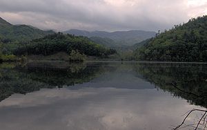
The Tallassee site is now submerged by Chilhowee Lake, an impoundment of the Little Tennessee River created by the completion of Chilhowee Dam
Chilhowee Dam
Chilhowee Dam is a hydroelectric dam located in Blount and Monroe counties, Tennessee, between river mile 33 and 34 on the Little Tennessee River. Construction began in 1955 and was completed in 1957. The dam's reservoir covers approximately at normal full pool and has a drainage area of . The...
in 1957. The shoreline above the site is now home to the Calderwood Hydroelectric Development Area, which was established by the Aluminum Company of America
Alcoa
Alcoa Inc. is the world's third largest producer of aluminum, behind Rio Tinto Alcan and Rusal. From its operational headquarters in Pittsburgh, Pennsylvania, Alcoa conducts operations in 31 countries...
in the 1920s as a base for the construction of Cheoah
Cheoah Dam
The Cheoah Dam is a hydroelectric complex located in Graham and Swain counties, North Carolina on the Little Tennessee River between river miles 51 and 52. The Cheoah Development consists of a dam and powerhouse, the first of several constructed by the Tallassee Power Company, now Tapoco...
, Santeetlah
Santeetlah Dam
Santeetlah Dam is a hydroelectric development on the Cheoah River in Graham County, North Carolina. The dam together with a pipeline/tunnel facility, and a powerhouse form the Santeetlah Development...
, and Calderwood
Calderwood Dam
Calderwood Dam is a hydroelectric dam located along the Little Tennessee River in Blount and Monroe counties, Tennessee. Completed in 1930, the dam is owned and maintained by Tapoco, a subsidiary of the Aluminum Company of America , although the Tennessee Valley Authority controls the dam's...
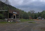
dams further up the river. The modern hamlet of Tallassee— established in the early 20th century— is located 7 miles (11.3 km) downstream, near Chilhowee Dam.
Geographical setting
Tennessee River
The Tennessee River is the largest tributary of the Ohio River. It is approximately 652 miles long and is located in the southeastern United States in the Tennessee Valley. The river was once popularly known as the Cherokee River, among other names...
near Lenoir City
Lenoir City, Tennessee
Lenoir City is a city in Loudon County, Tennessee, United States. Its population was 8,642 at the 2010 census. It is included in the Knoxville Metropolitan Area....
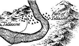
. Chilhowee Dam, situated approximately 34 miles (54.7 km) above the mouth of the river, retains a reservoir that spans the river for 10 miles (16.1 km), all the way to the base of Calderwood Dam. The Tallassee site was located 41.5 miles (66.8 km) above the river's mouth, at the river's confluence with Tallassee Creek. According to 18th-century records, the village was situated on both banks of the river. Calderwood Dam is located just 2 miles (3.2 km) above the Tallassee site, opposite a U-shaped bend in the river.
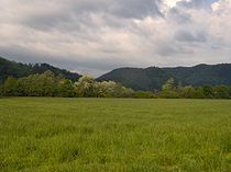
The Tallassee site is surrounded by high mountains on all sides. The Great Smoky Mountains
Great Smoky Mountains
The Great Smoky Mountains are a mountain range rising along the Tennessee–North Carolina border in the southeastern United States. They are a subrange of the Appalachian Mountains, and form part of the Blue Ridge Physiographic Province. The range is sometimes called the Smoky Mountains or the...
rise to the north and east and the Unicoi Mountains
Unicoi Range
The Unicoi Mountains are a mountain range rising along the border between Tennessee and North Carolina in the southeastern United States. They are part of the Blue Ridge Mountain Province of the Southern Appalachian Mountains. The Unicois are located immediately south of the Great Smoky Mountains...
rise to the south and west. The Little Tennessee provides the immediate boundary between the Great Smoky Mountains National Park
Great Smoky Mountains National Park
Great Smoky Mountains National Park is a United States National Park and UNESCO World Heritage Site that straddles the ridgeline of the Great Smoky Mountains, part of the Blue Ridge Mountains, which are a division of the larger Appalachian Mountain chain. The border between Tennessee and North...
and the Cherokee National Forest
Cherokee National Forest
The Cherokee National Forest is a large National Forest created on July 19, 1936, by U.S. President Franklin Roosevelt, operated by the U.S. Forest Service and encompassing some 640,000 acres .-Location:...
.
The Calderwood Hydroelectric Development Area— located on the shores above the ancient Tallassee site— is accessible just off U.S. Route 129
U.S. Route 129
U.S. Route 129 is an offshoot route of U.S. Route 29, which it intersects near Athens, Georgia. US 129 currently runs for 582 miles from Knoxville, Tennessee, to Chiefland, Florida, at U.S. Route 19 and U.S. Route 98. It passes through the states of Tennessee, North Carolina, Georgia and Florida...
approximately 6 miles (9.7 km) south of the road's Foothills Parkway
Foothills Parkway
The Foothills Parkway is a national parkway which, if completed, will traverse the foothills of the northern Great Smoky Mountains in East Tennessee, located in the Southeastern United States. The 71-mile parkway will ideally connect U.S...
junction. The area is open to the public daily from 8 A.M to 3 P.M. Just beyond Calderwood, US-129 enters a dangerous switchback-laden stretch of road known as "The Dragon."
History
Citico (Tellico archaeological site)
Citico is a prehistoric and historic Native American site in Monroe County, Tennessee, in the southeastern United States. The site's namesake Cherokee village was the largest of the Overhill towns, housing an estimated population of 1,000 by the mid-18th century...
and Tanasi
Tanasi
Tanasi is a historic Overhill Cherokee village site in Monroe County, Tennessee, in the southeastern United States. The village is best known as the namesake for the state of Tennessee...
. The "head man" of Tallassee was one of several Overhill and Middle town chiefs that met with Colonel George Chicken at the Tanasi townhouse in 1725 to forge an alliance against the Creeks. Tallassee again appears on Henry Popple's 1733 "Map of the British Empire in North America" along with Citico and Tanasi. In 1751, South Carolina records list Tallassee as one of seven Overhill towns. The same seven are shown on John Mitchell's 1755 map of North America.
In 1761-1762, Henry Timberlake
Henry Timberlake
Henry Timberlake was a colonial Anglo-American officer, journalist, and cartographer. He was born in Virginia in 1730 and died in England...
visited the Overhill towns as a peace envoy. Timberlake's map shows a townhouse and 22 dwellings (15 on the east bank and 7 on the west bank) at Tallassee. The map also reports 47 warriors residing at Tallassee— the third smallest contingent in the valley (only Mialoquo
Mialoquo
Mialoquo is a prehistoric and historic Native American site in Monroe County, Tennessee, in the southeastern United States. The site saw significant periods of occupation during the Mississippian period and later as a Cherokee refugee village...
and Tanasi had fewer warriors)— and states that Tallassee's "governor" had recently died and had yet to be replaced.
The Chickamauga Wars
Chickamauga wars
The Chickamauga Wars were a series of raids, campaigns, ambushes, minor skirmishes, and several full-scale frontier battles which were a continuation of the Cherokee struggle against encroachment by American frontiersmen from the former British colonies...
, which raged in the late 1770s, 1780s, and early 1790s, saw the destruction of most of the Overhill towns and the valley's subsequent decline. In 1776, Colonel William Christian
William Christian (Virginia)
William Christian was an "Indian fighter", Continental soldier, militiaman and politician from Virginia who served in the era of the American Revolution. He was a signatory to the Fincastle Resolutions and founder of Fort William...
invaded the Overhill country and destroyed a number of villages, but spared Tallassee. A militia detachment under Major Jonathan Tipton attempted to burn Tallassee in 1780, but abandoned his assault when the river proved impassable. Tallassee was finally burned by John Sevier
John Sevier
John Sevier served four years as the only governor of the State of Franklin and twelve years as Governor of Tennessee. As a U.S. Representative from Tennessee from 1811 until his death...
in 1788, largely in retaliation for the Nine Mile Creek massacre. The village was attacked again in 1795 by Colonel Alexander Kelley, killing 8 villagers. Tallassee was abandoned in 1819 after the Cherokee signed the Treaty of Calhoun, ceding the Little Tennessee Valley to the United States. For most of the 19th and early 20th centuries, Tallassee was the site of a river ford
Ford (crossing)
A ford is a shallow place with good footing where a river or stream may be crossed by wading or in a vehicle. A ford is mostly a natural phenomenon, in contrast to a low water crossing, which is an artificial bridge that allows crossing a river or stream when water is low.The names of many towns...
connecting the Calloway Turnpike and the Parson's Turnpike.
The modern hamlet of Tallassee
Archaeological findings
When ALCOA announced plans to build Chilhowee Dam in 1955, the Knoxville Chapter of the Tennessee Archaeological Society (under the guidance of Thomas Lewis and Madeline Kneburg of the University of Tennessee) began conducting salvage excavations at the Chilhowee and Tallassee sites, both of which would be flooded by the reservoir. As surface investigations recovered few artifacts at Chilhowee, however, the focus was shifted to Tallassee.Materials gathered from the Tallassee excavations revealed sporadic habitation dating to as early as the Woodland period
Woodland period
The Woodland period of North American pre-Columbian cultures was from roughly 1000 BCE to 1000 CE in the eastern part of North America. The term "Woodland Period" was introduced in the 1930s as a generic header for prehistoric sites falling between the Archaic hunter-gatherers and the...
(1000 B.C. - 1000 A.D.) and occurring throughout the Mississippian period
Mississippian culture
The Mississippian culture was a mound-building Native American culture that flourished in what is now the Midwestern, Eastern, and Southeastern United States from approximately 800 CE to 1500 CE, varying regionally....
(900-1600 A.D.). A prehistoric substructure mound was also located at the site, on the east bank of the river. Excavators uncovered 145 burials at Tallassee— 27 of which were classified as Cherokee— and 18 refuse pits. Grave goods accompanying the Cherokee burials included glass beads, iron tools, brass implements, copper arrowheads, and a jaw harp. Excavators also uncovered remnants of a house that had been burned and the foundations of an early 19th-century cabin.