

Tactical Air Navigation
Encyclopedia

Navigation
Navigation is the process of monitoring and controlling the movement of a craft or vehicle from one place to another. It is also the term of art used for the specialized knowledge used by navigators to perform navigation tasks...
system used by military aircraft. It provides the user with bearing and distance (slant-range) to a ground or ship-borne station. It is a more accurate version of the VOR
VHF omnidirectional range
VOR, short for VHF omnidirectional radio range, is a type of radio navigation system for aircraft. A VOR ground station broadcasts a VHF radio composite signal including the station's identifier, voice , and navigation signal. The identifier is typically a two- or three-letter string in Morse code...
/DME
Distance Measuring Equipment
Distance measuring equipment is a transponder-based radio navigation technology that measures distance by timing the propagation delay of VHF or UHF radio signals....
system that provides bearing
Bearing (navigation)
In marine navigation, a bearing is the direction one object is from another object, usually, the direction of an object from one's own vessel. In aircraft navigation, a bearing is the actual compass direction of the forward course of the aircraft...
and range
Distance
Distance is a numerical description of how far apart objects are. In physics or everyday discussion, distance may refer to a physical length, or an estimation based on other criteria . In mathematics, a distance function or metric is a generalization of the concept of physical distance...
information for civil aviation
Civil aviation
Civil aviation is one of two major categories of flying, representing all non-military aviation, both private and commercial. Most of the countries in the world are members of the International Civil Aviation Organization and work together to establish common standards and recommended practices...
. The DME portion of the TACAN system is available for civil use; at VORTAC facilities where a VOR is combined with a TACAN, civil aircraft can receive VOR/DME readings.
Aircraft equipped with TACAN avionics
Avionics
Avionics are electronic systems used on aircraft, artificial satellites and spacecraft.Avionic systems include communications, navigation, the display and management of multiple systems and the hundreds of systems that are fitted to aircraft to meet individual roles...
can use this system for enroute navigation as well as non-precision approaches to landing fields. The space shuttle
Space Shuttle
The Space Shuttle was a manned orbital rocket and spacecraft system operated by NASA on 135 missions from 1981 to 2011. The system combined rocket launch, orbital spacecraft, and re-entry spaceplane with modular add-ons...
is one such vehicle that was designed to use TACAN navigation (although it has since been upgraded with GPS as a replacement).
The typical TACAN onboard user panel has control switches for setting the channel (corresponding to the desired surface station's assigned frequency), the operation mode for either Transmit/Receive (T/R, to get both bearing and range) or Receive Only (REC, to get bearing but not range). Capability was later upgraded to include an Air-to-Air mode (A/A) where two airborne users can get relative slant-range information. Depending on the installation, Air-to-Air mode may provide range, closure (relative velocity of the other unit), and bearing, though an air-to-air bearing is noticeably less precise than a ground-to-air bearing.
History
The TACAN navigation system is an evolution of radioRadio
Radio is the transmission of signals through free space by modulation of electromagnetic waves with frequencies below those of visible light. Electromagnetic radiation travels by means of oscillating electromagnetic fields that pass through the air and the vacuum of space...
transponder
Transponder
In telecommunication, the term transponder has the following meanings:...
navigation systems that date back to the British Oboe system
Oboe (navigation)
Oboe was a British aerial blind bombing targeting system in World War II, based on radio transponder technology. Oboe accurately measured the distance to an aircraft, and gave the pilot guidance on whether or not they were flying along a pre-selected circular route. The route was only 35 yards...
of World War II
World War II
World War II, or the Second World War , was a global conflict lasting from 1939 to 1945, involving most of the world's nations—including all of the great powers—eventually forming two opposing military alliances: the Allies and the Axis...
.
Operation
Frequency
Frequency is the number of occurrences of a repeating event per unit time. It is also referred to as temporal frequency.The period is the duration of one cycle in a repeating event, so the period is the reciprocal of the frequency...
band 960-1215 MHz. The bearing unit of TACAN is more accurate than a standard VOR since it makes use of a two frequency principle, with 15 Hz and 135 Hz components.
The distance measurement component of TACAN operates with the same specifications as civil DMEs. Therefore to reduce the number of required stations, TACAN stations are frequently co-located with VOR facilities. These co-located stations are known as VORTACs. This is a station composed of a VOR for civil bearing information and a TACAN for military bearing information and military/civil distance measuring information. The TACAN transponder performs the function of a DME without the need for a separate, co-located DME. Because the rotation of the antenna creates a large portion of the azimuth signal, if the antenna fails, the azimuth component is no longer available and the TACAN downgrades to a DME only mode.
Accuracy
Theoretically a TACAN should provide a ninefold increase in accuracy compared to a VOR but operational use has shown only a ±3 fold increase.Accuracy of the 135 Hz azimuth component is ±1° or ±63 m at 3.47 km. Accuracy of the DME portion is 926 m (±0.5 nautical mile
Nautical mile
The nautical mile is a unit of length that is about one minute of arc of latitude along any meridian, but is approximately one minute of arc of longitude only at the equator...
) or 3 percent of slant range distance, whichever is greater - see FAA 9840.1 1982.
TACAN stations can provide distance up to 390NM
Benefits
Drawbacks
_tacan.jpg)
EMCON
EMCON is a military condition in which electromagnetic emissions do not exceed a set limit. This helps to avoid electronic detection. The EMCON condition can be passed via an EMCON bill, directives, OP orders, message traffic or embarked or area commander.-External links:* ....
) and stealth. Naval TACAN operations are designed so an aircraft can find the ship and land. There is no encryption involved, an enemy can simply use the range and bearing provided to attack a ship equipped with a TACAN. Some TACANs have the ability to employ a "Demand Only" mode wherein they will only transmit when interrogated by an aircraft on-channel. It is likely that TACAN will be replaced with a differential GPS system similar to the Local Area Augmentation System
Local Area Augmentation System
The Local Area Augmentation System is an all-weather aircraft landing system based on real-time differential correction of the GPS signal. Local reference receivers located around the airport send data to a central location at the airport. This data is used to formulate a correction message, which...
called JPALS. The Joint Precision Approach and Landing System
Joint Precision Approach and Landing System
The Joint Precision Approach and Landing System is a military, all-weather landing system based on real-time differential correction of the GPS signal, augmented with a local area correction message, and transmitted to the user via secure means...
has a low probability of intercept to prevent enemy detection and an aircraft carrier version can be used for autoland operations.
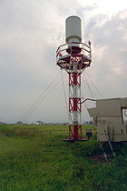
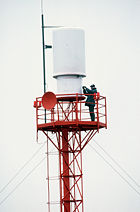
Some systems used in the United States modulate the transmitted signal by using a 900 RPM rotating antenna. Since this antenna is fairly large and must rotate 24 hours a day, it can cause reliability issues. Modern systems have antennas that use electronic rotation (instead of mechanical rotation) with no moving parts.
Future
Like all other forms of ground-based aircraft radio navigation currently used, it is likely that TACAN will be replaced by some form of space based navigational system such as GPS.See also
- Battle of Lima Site 85Battle of Lima Site 85The Battle of Lima Site 85, also called Battle of Phou Pha Thi, was fought as part of a military campaign waged during the Vietnam War and Laotian Civil War by the Vietnam People’s Army and the Pathet Lao, against airmen of the United States Air Force 1st Combat Evaluation Group, elements of the ...
(SACStrategic Air CommandThe Strategic Air Command was both a Major Command of the United States Air Force and a "specified command" of the United States Department of Defense. SAC was the operational establishment in charge of America's land-based strategic bomber aircraft and land-based intercontinental ballistic...
TACAN captured March 1968) - Distance Measuring EquipmentDistance Measuring EquipmentDistance measuring equipment is a transponder-based radio navigation technology that measures distance by timing the propagation delay of VHF or UHF radio signals....
- VHF Omnidirectional RangeVHF omnidirectional rangeVOR, short for VHF omnidirectional radio range, is a type of radio navigation system for aircraft. A VOR ground station broadcasts a VHF radio composite signal including the station's identifier, voice , and navigation signal. The identifier is typically a two- or three-letter string in Morse code...
- Global Positioning SystemGlobal Positioning SystemThe Global Positioning System is a space-based global navigation satellite system that provides location and time information in all weather, anywhere on or near the Earth, where there is an unobstructed line of sight to four or more GPS satellites...
- Wide Area Augmentation SystemWide Area Augmentation SystemThe Wide Area Augmentation System is an air navigation aid developed by the Federal Aviation Administration to augment the Global Positioning System , with the goal of improving its accuracy, integrity, and availability...
External links
- Rantec Microwave Systems - Manufacturer of non-rotating TACAN antennas - Complete with antenna internal photos and specs
- Fernau Avionics - Tacan 2010 System