

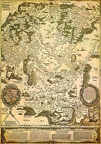
Tabula Hungariae
Encyclopedia
Hungary
Hungary , officially the Republic of Hungary , is a landlocked country in Central Europe. It is situated in the Carpathian Basin and is bordered by Slovakia to the north, Ukraine and Romania to the east, Serbia and Croatia to the south, Slovenia to the southwest and Austria to the west. The...
, which has supposedly been made by Hungarian Lázár deák before 1528. It was inscribed on UNESCO
UNESCO
The United Nations Educational, Scientific and Cultural Organization is a specialized agency of the United Nations...
's Memory of the World Register in 2007.
Description
The map is approximately 65×85 cm in size and is oriented in southwest-northeast direction. It shows the settlements and landmarks of the Kingdom of HungaryKingdom of Hungary
The Kingdom of Hungary comprised present-day Hungary, Slovakia and Croatia , Transylvania , Carpatho Ruthenia , Vojvodina , Burgenland , and other smaller territories surrounding present-day Hungary's borders...
in the early 16th century. The southern areas occupied by the Ottoman Empire
Ottoman Empire
The Ottoman EmpireIt was usually referred to as the "Ottoman Empire", the "Turkish Empire", the "Ottoman Caliphate" or more commonly "Turkey" by its contemporaries...
are marked with different colors. As the only covered parts outside the border are in the south, it is thought that the purpose of the creation of the map was the preparations for the war against the Ottomans. Some of the settlements shown on the map vanished during the years of Ottoman wars and oppression.
The most valued information on the map are the names and descriptions of settlements. There are approximately 1400 geographical names on the map, of which 1270 are names of settlements (365 on the territory of post-Trianon
Treaty of Trianon
The Treaty of Trianon was the peace agreement signed in 1920, at the end of World War I, between the Allies of World War I and Hungary . The treaty greatly redefined and reduced Hungary's borders. From its borders before World War I, it lost 72% of its territory, which was reduced from to...
Hungary.)
At the bottom of the map is the description of the country in German and Latin.
Names of settlements
The geographical names had been transcribed differently than today. For example today's é was written ee, today's ö was ew. It is also noted that c is sometimes written tz, which is a characteristic of the Old High GermanOld High German
The term Old High German refers to the earliest stage of the German language and it conventionally covers the period from around 500 to 1050. Coherent written texts do not appear until the second half of the 8th century, and some treat the period before 750 as 'prehistoric' and date the start of...
orthography
Orthography
The orthography of a language specifies a standardized way of using a specific writing system to write the language. Where more than one writing system is used for a language, for example Kurdish, Uyghur, Serbian or Inuktitut, there can be more than one orthography...
. These may be created by contributors, who prepared the work for printing. However, with some other names, Lázár used the pronunciation of Hungarian dialects.
Printing
The map was printed with the aid of Georg TannstetterGeorg Tannstetter
Georg Tannstetter , also called Georgius Collimitius, was a humanist teaching at the University of Vienna. He was a medical doctor, mathematician, astronomer, cartographer, and the personal physician of the emperors Maximilian I and Ferdinand I. He also wrote under the pseudonym of "Lycoripensis"...
, was paid by Johannes Cuspinianus, in the press of Petrus Apianus
Petrus Apianus
Petrus Apianus , also known as Peter Apian, was a German humanist, known for his works in mathematics, astronomy and cartography.The lunar crater Apianus and minor planet 19139 Apian are named in his honour....
in Ingolstadt
Ingolstadt
Ingolstadt is a city in the Free State of Bavaria, in the Federal Republic of Germany. It is located along the banks of the Danube River, in the center of Bavaria. As at 31 March 2011, Ingolstadt had 125.407 residents...
.
Legacy
There were only a few maps printed, almost all of them lost through history, so researchers could only know it from descriptions. However, in the early 1880s, one map was unexpectedly found. It was bought by collector Sándor Apponyi in 1882. The map was transferred in 1924 to the National Széchényi LibraryNational Széchényi Library
The National Széchényi Library is a library in Budapest, Hungary. It is one of the two Hungarian national libraries, the other being the University of Debrecen Library.-History:...
, and is also there currently.
Later versions
There had been made several copies of the original map until 1552 but these did not survive. However, there were maps made using Lázár's map also after 1552, with title Tabula Hungariae, illetve Nova descriptio totius Hungariae. Six different versions are known:- Giovanni Andrea Vavassore (worked 1510-1572), VeniceVeniceVenice is a city in northern Italy which is renowned for the beauty of its setting, its architecture and its artworks. It is the capital of the Veneto region...
, 1553 - Pirro LigorioPirro LigorioPirro Ligorio was an Italian architect, painter, antiquarian and garden designer.-Biography:Ligorio was born in Naples. In 1534 he moved to Rome, where he developed his interest in antiquities, and was named superintendent to the ancient monuments by the Popes Pius IV and Paul IV...
(1496-1583), RomeRomeRome is the capital of Italy and the country's largest and most populated city and comune, with over 2.7 million residents in . The city is located in the central-western portion of the Italian Peninsula, on the Tiber River within the Lazio region of Italy.Rome's history spans two and a half...
, 1558 (lost), 1599 - Antonio Lafreri (1512-1577), Rome, 1558, 1559, 156?
- János Zsámboky (1531-1584), ViennaViennaVienna is the capital and largest city of the Republic of Austria and one of the nine states of Austria. Vienna is Austria's primary city, with a population of about 1.723 million , and is by far the largest city in Austria, as well as its cultural, economic, and political centre...
, 1566 - Claudio Duchetti (1554-1597), Rome, 1577
- Giovanni Orlandi (worked 1600-1604), Rome, 1602